


测绘学报 ›› 2024, Vol. 53 ›› Issue (8): 1610-1623.doi: 10.11947/j.AGCS.2024.20230224
谢志伟1,2,3,4( ), 翟帅智1, 张丰源3,4,5(), 陈旻2,3,4, 孙立双1
收稿日期:2023-06-12
出版日期:2024-09-25
发布日期:2024-09-25
通讯作者:
张丰源
E-mail:zwxrs@sjzu.edu.cn;zwxrs@sjzu.edu.cn;zhangfengyuan@nnu.edu.cn
作者简介:谢志伟(1986—),男,副教授,研究方向为图像识别和城市空间大数据分析。E-mail:zwxrs@sjzu.edu.cn
基金资助:
Zhiwei XIE1,2,3,4(), Shuaizhi ZHAI1, Fengyuan ZHANG3,4,5(), Min CHEN2,3,4, Lishuang SUN1
Received:2023-06-12
Online:2024-09-25
Published:2024-09-25
Contact:
Fengyuan ZHANG
E-mail:zwxrs@sjzu.edu.cn;zwxrs@sjzu.edu.cn;zhangfengyuan@nnu.edu.cn
About author:XIE Zhiwei (1986—), male, associate professor, majors in image recognition and urban spatial big data analysis. E-mail: zwxrs@sjzu.edu.cn
Supported by:摘要:
传统面向对象分类多采用遥感影像的光谱特征,忽略了影像对象之间的空间特征。本文提出了一种采用改进归纳式图神经网络的高分遥感影像面向对象分类方法,实现了光谱-空间复合节点相似度的融合系数自适应调节,以及邻域节点采样最佳数量的自动确定。首先,改进KNN图构建方法,采用标准差信息量评价法确定用于构建光谱特征和空间特征的复合节点相似度的融合系数;然后,利用反馈曲线法确定最佳的采样邻域节点数量,使用GraphSAGE节点嵌入完成特征表达;最后,依托Softmax函数预测节点类别。以GID和BDCI2017数据集为试验数据,本文的构图方法相较于改进前的构图方法在分类精度上有所提升。本文分类方法的平均Kappa系数和总体精度分别优于CART分类树算法、GCN算法、GAT算法、LANet算法、CCTNet算法和SLCNet算法0.31、0.14、0.13、0.12、0.08、0.02和42.31%、7.4%、6.73%、8.69%、6.03%、1.52%,并且在植被和建设用地提取上具有较好的稳健性。本文方法为高分遥感影像土地覆盖分类提供了有效的工具。
中图分类号:
谢志伟, 翟帅智, 张丰源, 陈旻, 孙立双. 面向对象高分影像归纳式图神经网络分类法[J]. 测绘学报, 2024, 53(8): 1610-1623.
Zhiwei XIE, Shuaizhi ZHAI, Fengyuan ZHANG, Min CHEN, Lishuang SUN. Object-oriented high-resolution image classification using inductive graph neural networks[J]. Acta Geodaetica et Cartographica Sinica, 2024, 53(8): 1610-1623.

图1
本文算法流程"
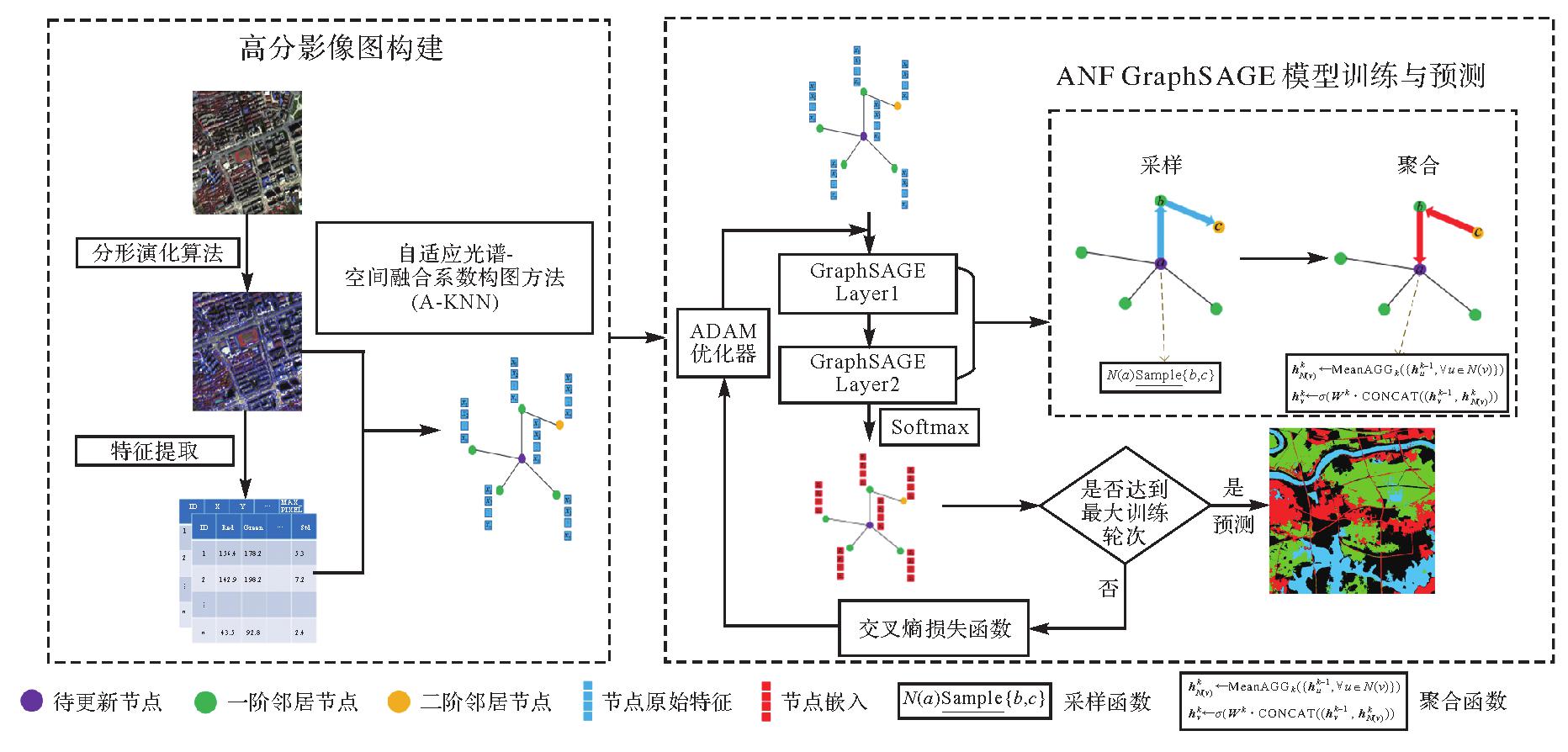
图2
图结构构建流程"

算法1
GraphSAGE均值节点嵌入"
| 输入:图结构数据G=(V,E);采样深度K;权重矩阵Wk,∀k∈{1,2,…,K};平均聚合函数Mean AGG();采样函数N() | ||
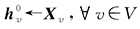 ; ; | ||
| for k=1,2,…,K do | ||
| for v∈V do | ||
 | ||
| end | ||
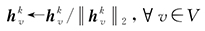 | ||
| end | ||
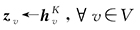 | ||
| 输出:节点向量表示zv | ||
图3
试验数据"
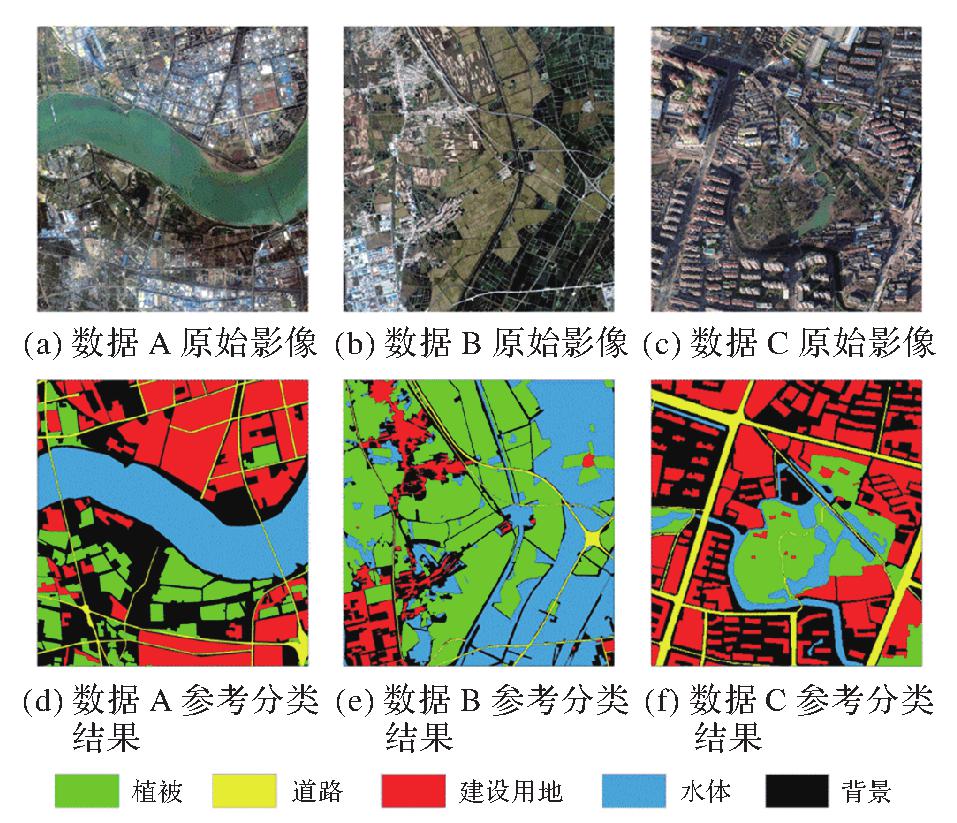
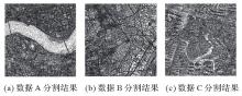
图4
分割结果"
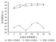
图5
反馈曲线法采样邻域节点数量估算"
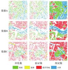
图6
各数据训练集、验证集和测试集样本空间分布"
图7
不同方法在3组数据上的分类"
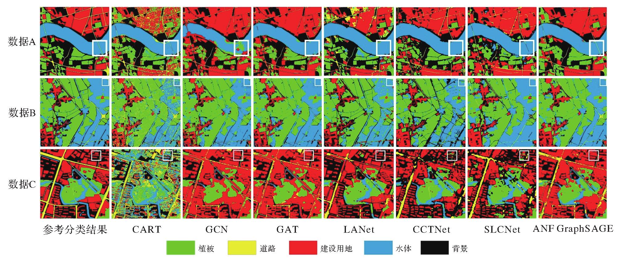
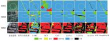
图8
不同方法分类细节"

表1
不同方法在3组数据上的分类结果"
| 算法类别 | 数据集 | 各类地物分类准确率/(%) | OA/(%) | Kappa系数 | |||
|---|---|---|---|---|---|---|---|
| 建设用地 | 道路 | 植被 | 水体 | ||||
| CART | 数据A | 10.78 | 31.52 | 88.36 | 95.61 | 52.21 | 0.39 |
| 数据B | 9.71 | 21.22 | 86.68 | 80.44 | 75.27 | 0.61 | |
| 数据C | 13.38 | 5.23 | 22.19 | 70.61 | 20.77 | 0.10 | |
| GCN | 数据A | 98.45 | 7.51 | 82.73 | 78.19 | 84.78 | 0.76 |
| 数据B | 88.42 | 21.33 | 98.88 | 92.64 | 93.71 | 0.88 | |
| 数据C | 97.03 | 5.15 | 78.01 | 5.92 | 74.48 | 0.49 | |
| GAT | 数据A | 97.47 | 7.75 | 65.15 | 98.62 | 86.85 | 0.79 |
| 数据B | 92.62 | 10.96 | 98.16 | 94.26 | 94.51 | 0.90 | |
| 数据C | 96.37 | 5.38 | 75.86 | 5.45 | 73.62 | 0.47 | |
| LANet | 数据A | 75.49 | 33.29 | 78.78 | 98.37 | 80.01 | 0.71 |
| 数据B | 95.76 | 12.17 | 98.92 | 83.01 | 90.27 | 0.84 | |
| 数据C | 96.12 | 34.93 | 74.58 | 51.92 | 78.80 | 0.64 | |
| CCTNet | 数据A | 92.40 | 57.33 | 77.15 | 98.96 | 88.36 | 0.81 |
| 数据B | 90.42 | 58.98 | 94.58 | 85.92 | 87.48 | 0.82 | |
| 数据C | 91.48 | 50.33 | 76.28 | 59.44 | 81.23 | 0.67 | |
| SLCNet | 数据A | 96.47 | 40.31 | 88.01 | 99.79 | 93.87 | 0.91 |
| 数据B | 97.13 | 55.56 | 94.77 | 99.53 | 96.64 | 0.94 | |
| 数据C | 90.71 | 45.47 | 81.16 | 52.62 | 80.09 | 0.66 | |
| ANF GraphSAGE | 数据A | 97.32 | 13.32 | 97.58 | 99.22 | 94.17 | 0.91 |
| 数据B | 97.65 | 56.40 | 98.86 | 97.88 | 97.50 | 0.95 | |
| 数据C | 97.72 | 39.13 | 77.55 | 53.73 | 83.51 | 0.69 | |
表2
各算法在3组数据上的运行时间"
| 运行阶段 | 数据集 | CART | GCN | GAT | LANet | CCTNet | SLCNet | ANF GraphSAGE |
|---|---|---|---|---|---|---|---|---|
| 训练阶段 | 数据A | 13 | 4439 | 4483 | 73 474 | 84 714 | 18 035 | 7352 |
| 数据B | 15 | 7093 | 7144 | 73 474 | 84 714 | 18 035 | 10 253 | |
| 数据C | 12 | 3829 | 3873 | 76 252 | 85 701 | 18 154 | 6850 | |
| 预测阶段 | 数据A | 3 | 20 | 52 | 23 | 25 | 31 | 22 |
| 数据B | 5 | 22 | 51 | 28 | 22 | 29 | 16 | |
| 数据C | 3 | 26 | 52 | 33 | 17 | 34 | 15 |
表3
不同模型设置在3组数据上的总体精度"
| 方法 | 数据集 | OA/(%) |
|---|---|---|
| G-GraphSAGE | 数据A | 93.32 |
| 数据B | 94.45 | |
| 数据C | 74.05 | |
| S-GraphSAGE | 数据A | 82.92 |
| 数据B | 91.06 | |
| 数据C | 73.78 | |
| MNF GraphSAGE | 数据A | 94.03 |
| 数据B | 97.19 | |
| 数据C | 83.66 | |
| ANF GraphSAGE | 数据A | 94.17 |
| 数据B | 97.50 | |
| 数据C | 83.51 |
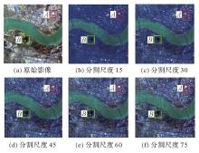
图9
不同分割尺度下的分割结果"
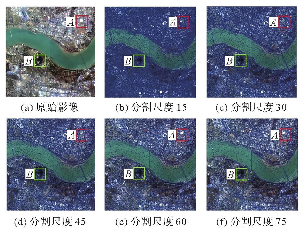
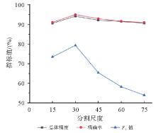
图10
不同分割尺度下的精度曲线"
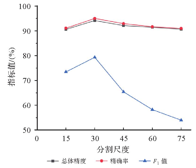
图11
不同λ值和k值得到的分类结果"
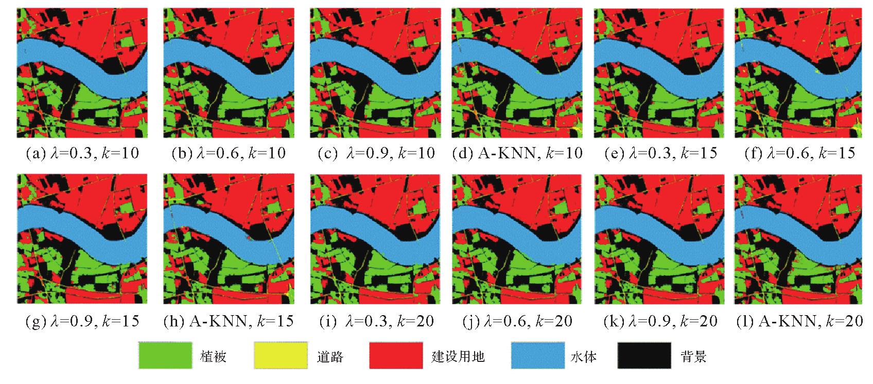
表4
不同λ值和k值分类结果的Kappa系数"
| 参数值 | k=10 | k=15 | k=20 |
|---|---|---|---|
| λ=0.3 | 0.88 | 0.89 | 0.89 |
| λ=0.6 | 0.89 | 0.90 | 0.88 |
| λ=0.9 | 0.87 | 0.86 | 0.89 |
| 自适应权重 | 0.90 | 0.91 | 0.84 |
| [1] | 王密, 杨芳. 智能遥感卫星与遥感影像实时服务[J]. 测绘学报, 2019, 48(12): 1586-1594. DOI: 10.11947/j.AGCS.2019.20190454. |
| WANG Mi, YANG Fang. Intelligent remote sensing satellite and remote sensing image real-time service[J]. Acta Geodaetica et Cartographica Sinica, 2019, 48(12): 1586-1594. DOI: 10.11947/j.AGCS.2019.20190454. | |
| [2] | ZHU Qiqi, GUO Xi, DENG Weihuan, et al. Land-use/land-cover change detection based on a Siamese global learning framework for high spatial resolution remote sensing imagery[J]. ISPRS Journal of Photogrammetry and Remote Sensing, 2022, 184: 63-78. |
| [3] | 周培诚, 程塨, 姚西文, 等. 高分辨率遥感影像解译中的机器学习范式[J]. 遥感学报, 2021, 25(1): 182-197. |
| ZHOU Peicheng, CHENG Gong, YAO Xiwen, et al. Machine learning paradigms in high-resolution remote sensing image interpretation[J]. National Remote Sensing Bulletin, 2021, 25(1): 182-197. | |
| [4] | KAUR S, BANSAL R K, MITTAL M, et al. Mixed pixel decomposition based on extended fuzzy clustering for single spectral value remote sensing images[J]. Journal of the Indian Society of Remote Sensing, 2019, 47(3): 427-437. |
| [5] | 王志盼, 沈彦, 王亮, 等. 单类分类框架下的高分辨率遥感影像建筑物变化检测算法[J]. 武汉大学学报(信息科学版), 2020, 45(10): 1610-1618. |
| WANG Zhipan, SHEN Yan, WANG Liang, et al. High-resolution remote sensing image building change detection based on one-class classifier framework[J]. Geomatics and Information Science of Wuhan University, 2020, 45(10): 1610-1618. | |
| [6] | LI Zhiqing, LI Erzhu, SAMAT A, et al. An object-oriented CNN model based on improved superpixel segmentation for high-resolution remote sensing image classification[J]. IEEE Journal of Selected Topics in Applied Earth Observations and Remote Sensing, 2022, 15: 4782-4796. |
| [7] | DOU Jie, CHANG K T, CHEN Shuisen, et al. Automatic case-based reasoning approach for landslide detection: integration of object-oriented image analysis and a genetic algorithm[J]. Remote Sensing, 2015, 7(4): 4318-4342. |
| [8] | KATTENBORN T, LEITLOFF J, SCHIEFER F, et al. Review on convolutional neural networks (CNN) in vegetation remote sensing[J]. ISPRS Journal of Photogrammetry and Remote Sensing, 2021, 173: 24-49. |
| [9] | GONG Jianya, JI Shunping. Photogrammetry and deep learning[J]. Journal of Geodesy and Geoinformation Science, 2018, 1(1): 1-15. |
| [10] | PAN Deng, ZHANG Meng, ZHANG Bo. A generic FCN-based approach for the road-network extraction from VHR remote sensing images-using OpenStreetMap as benchmarks[J]. IEEE Journal of Selected Topics in Applied Earth Observations and Remote Sensing, 2021, 14: 2662-2673. |
| [11] | HUANG Wei, TANG Hong, XU Penglei. OEC-RNN: object-oriented delineation of rooftops with edges and corners using the recurrent neural network from the aerial images[J]. IEEE Transactions on Geoscience and Remote Sensing, 2022, 60: 1-12. |
| [12] | AUDEBERT N, LE S B, LEFÈVRE S. Beyond RGB: very high resolution urban remote sensing with multimodal deep networks[J]. ISPRS Journal of Photogrammetry and Remote Sensing, 2018, 140: 20-32. |
| [13] | HONG Danfeng, GAO Lianru, YOKOYA N, et al. More diverse means better: multimodal deep learning meets remote-sensing imagery classification[J]. IEEE Transactions on Geoscience and Remote Sensing, 2020, 59(5): 4340-4354. |
| [14] | ROY S K, DERIA A, HONG Danfeng, et al. Multimodal fusion transformer for remote sensing image classification[J]. IEEE Transactions on Geoscience and Remote Sensing, 2023, 61: 1-20. |
| [15] | 靳志宾, 蒲英霞, 陈刚, 等. 基于地理加权的k-NN高分辨率遥感影像分类算法改进[J]. 遥感技术与应用, 2013, 28(1): 97-102. |
| JIN Zhibin, PU Yingxia, CHEN Gang, et al. The modified k-NN classifier for high spatial resolution remote sensing images based on geographical weighted models[J]. Remote Sensing Technology and Application, 2013, 28(1): 97-102. | |
| [16] | 洪亮, 冯亚飞, 彭双云, 等. 面向对象的多尺度加权联合稀疏表示的高空间分辨率遥感影像分类[J]. 测绘学报, 2022, 51(2): 224-237. DOI: 10.11947/j.AGCS.2022.20190290. |
| HONG Liang, FENG Yafei, PENG Shuangyun, et al. Classification of high spatial resolution remote sensing imagery based on object-oriented multi-scale weighted sparse representation[J]. Acta Geodaetica et Cartographica Sinica, 2022, 51(2): 224-237. DOI: 10.11947/j.AGCS.2022.20190290. | |
| [17] | YUAN Qiangqiang, SHEN Huanfeng, LI Tongwen, et al. Deep learning in environmental remote sensing: achievements and challenges[J]. Remote Sensing of Environment, 2020, 241: 111716. |
| [18] | CHENG Gong, XIE Xingxing, HAN Junwei, et al. Remote sensing image scene classification meets deep learning: challenges, methods, benchmarks, and opportunities[J]. IEEE Journal of Selected Topics in Applied Earth Observations and Remote Sensing, 2020, 13: 3735-3756. |
| [19] | 陈云浩, 冯通, 史培军, 等. 基于面向对象和规则的遥感影像分类研究[J]. 武汉大学学报(信息科学版), 2006, 31(4): 316-320. |
| CHEN Yunhao, FENG Tong, SHI Peijun, et al. Classification of remote sensing image based on object oriented and class rules[J]. Geomatics and Information Science of Wuhan University, 2006, 31(4): 316-320. | |
| [20] | 薄树奎, 韩新超, 丁琳. 面向对象影像分类中分割参数的选择[J]. 武汉大学学报(信息科学版), 2009, 34(5): 514-517. |
| BO Shukui, HAN Xinchao, DING Lin. Automatic selection of segmentation parameters for object oriented image classification[J]. Geomatics and Information Science of Wuhan University, 2009, 34(5): 514-517. | |
| [21] | SAHA S, ZHAO Shan, ZHU Xiaoxiang. Multitarget domain adaptation for remote sensing classification using graph neural network[J]. IEEE Geoscience and Remote Sensing Letters, 2022, 19: 1-5. |
| [22] | ZHOU Jie, CUI Ganqu, HU Shengding, et al. Graph neural networks: a review of methods and applications[J]. AI Open, 2020, 1: 57-81. |
| [23] | 吴博, 梁循, 张树森, 等. 图神经网络前沿进展与应用[J]. 计算机学报, 2022, 45(1): 35-68. |
| WU Bo, LIANG Xun, ZHANG Shusen, et al. Advances and applications in graph neural network[J]. Chinese Journal of Computers, 2022, 45(1): 35-68. | |
| [24] | LIU Ziyu, FENG Ruyi, WANG Lizhe, et al. Dual learning-based graph neural network for remote sensing image super-resolution[J]. IEEE Transactions on Geoscience and Remote Sensing, 2022, 60: 1-14. |
| [25] | 白铂, 刘玉婷, 马驰骋, 等. 图神经网络[J]. 中国科学(数学), 2020, 50(3): 367-384. |
| BAI Bo, LIU Yuting, MA Chicheng, et al. Graph neural network[J]. Scientia Sinica (Mathematica), 2020, 50(3): 367-384. | |
| [26] | CUI Wei, HE Xin, YAO Meng, et al. Knowledge and spatial pyramid distance-based gated graph attention network for remote sensing semantic segmentation[J]. Remote Sensing, 2021, 13(7): 1312. |
| [27] | QIN Anyong, SHANG Zhaowei, TIAN Jinyu, et al. Spectral-spatial graph convolutional networks for semisupervised hyperspectral image classification[J]. IEEE Geoscience and Remote Sensing Letters, 2019, 16(2): 241-245. |
| [28] | YANG Pan, TONG Lei, QIAN Bin, et al. Hyperspectral image classification with spectral and spatial graph using inductive representation learning network[J]. IEEE Journal of Selected Topics in Applied Earth Observations and Remote Sensing, 2021, 14: 791-800. |
| [29] | HONG Danfeng, GAO Lianru, YAO Jing, et al. Graph convolutional networks for hyperspectral image classification[J]. IEEE Transactions on Geoscience and Remote Sensing, 2021, 59(7): 5966-5978. |
| [30] | 刘杰, 尚学群, 宋凌云, 等. 图神经网络在复杂图挖掘上的研究进展[J]. 软件学报, 2022, 33(10): 3582-3618. |
| LIU Jie, SHANG Xuequn, SONG Lingyun, et al. Progress of graph neural networks on complex graph mining[J]. Journal of Software, 2022, 33(10): 3582-3618. | |
| [31] | 徐冰冰, 岑科廷, 黄俊杰, 等. 图卷积神经网络综述[J]. 计算机学报, 2020, 43(5): 755-780. |
| XU Bingbing, CEN Keting, HUANG Junjie, et al. A survey on graph convolutional neural network[J]. Chinese Journal of Computers, 2020, 43(5): 755-780. | |
| [32] | 康世泽, 吉立新, 张建朋. 一种基于图注意力网络的异质信息网络表示学习框架[J]. 电子与信息学报, 2021, 43(4): 915-922. |
| KANG Shize, JI Lixin, ZHANG Jianpeng. Heterogeneous information network representation learning framework based on graph attention network[J]. Journal of Electronics & Information Technology, 2021, 43(4): 915-922. | |
| [33] | CIANO G, ROSSI A, BIANCHINI M, et al. On inductive-transductive learning with graph neural networks[J]. IEEE Transactions on Pattern Analysis and Machine Intelligence, 2022, 44(2): 758-769. |
| [34] | HAMILTON W, YING Zhitao, LESKOVEC J. Inductive representation learning on large graphs[J]. Advances in Neural Information Processing Systems, 2017, 30: 1024-1034. |
| [35] | DING Yao, ZHAO Xiaofeng, ZHANG Zhili, et al. Graph sample and aggregate-attention network for hyperspectral image classification[J]. IEEE Geoscience and Remote Sensing Letters, 2022, 19: 1-5. |
| [36] | 贾永红, 谢志伟, 吕臻, 等. 一种新的遥感影像变化检测方法[J]. 武汉大学学报(信息科学版), 2016, 41(8): 1001-1006. |
| JIA Yonghong, XIE Zhiwei, LÜ Zhen, et al. A new change detection method of remote sensing image[J]. Geomatics and Information Science of Wuhan University, 2016, 41(8): 1001-1006. | |
| [37] | 佃袁勇, 方圣辉, 姚崇怀. 多尺度分割的高分辨率遥感影像变化检测[J]. 遥感学报, 2016, 20(1): 129-137. |
| DIAN Yuanyong, FANG Shenghui, YAO Chonghuai. Change detection for high-resolution images using multilevel segment method[J]. Journal of Remote Sensing, 2016, 20(1): 129-137. | |
| [38] | SZABÓ S, GÁCSI Z, BALÁZS B. Specific features of NDVI, NDWI and MNDWI as reflected in land cover categories[J]. Landscape & Environment, 2016, 10(3/4): 194-202. |
| [39] | 赵春雷, 钱拴, 黄强, 等. 基于降水量的白洋淀最低水位预测研究[J]. 中国生态农业学报(中英文), 2019, 27(8): 1238-1244. |
| ZHAO Chunlei, QIAN Shuan, HUANG Qiang, et al. Prediction of minimum water level in Baiyangdian Lake based on precipitation[J]. Chinese Journal of Eco-Agriculture, 2019, 27(8): 1238-1244. | |
| [40] | 季德强, 王海荣, 车淼, 等. KNN-GWD推荐模型及其应用[J]. 应用科学学报, 2022, 40(1): 145-154. |
| JI Deqiang, WANG Hairong, CHE Miao, et al. KNN-GWD recommendation model and its application[J]. Journal of Applied Sciences, 2022, 40(1): 145-154. | |
| [41] | ZUO Xibing, YU Xuchu, LIU Bing, et al. Graph inductive learning method for small sample classification of hyperspectral remote sensing images[J]. European Journal of Remote Sensing, 2020, 53(1): 349-357. |
| [42] | ZHANG Tao, SHAN Haoran, LITTLE M A. Causal GraphSAGE: a robust graph method for classification based on causal sampling[J]. Pattern Recognition, 2022, 128: 108696. |
| [43] | YANG Kunping, TONG Xinyi, XIA Guisong, et al. Hidden path selection network for semantic segmentation of remote sensing images[J]. IEEE Transactions on Geoscience and Remote Sensing, 2022, 60: 1-15. |
| [44] | DING Lei, TANG Hao, BRUZZONE L. LANet: local attention embedding to improve the semantic segmentation of remote sensing images[J]. IEEE Transactions on Geoscience and Remote Sensing, 2021, 59(1): 426-435. |
| [45] | YU Dawen, JI Shunping. Long-range correlation supervision for land-cover classification from remote sensing images[J]. IEEE Transactions on Geoscience and Remote Sensing, 2023, 61: 1-14. |
| [46] | WANG Hong, CHEN Xianzhong, ZHANG Tianxiang, et al. CCTNet: coupled CNN and transformer network for crop segmentation of remote sensing images[J]. Remote Sensing, 2022, 14(9): 1956. |
| [1] | 陈超, 梁锦涛, 杨刚, 孙伟伟, 龚绍军, 王建强. 面向土地覆盖精准分类的遥感特征参数优选方法[J]. 测绘学报, 2024, 53(7): 1401-1416. |
| [2] | 丁少鹏, 卢秀山, 刘如飞, 杨懿, 顾海燕, 李海涛. 联合目标特征引导与多重注意力的建筑物变化检测[J]. 测绘学报, 2024, 53(6): 1224-1235. |
| [3] | 薛志祥, 余旭初, 刘景正, 杨国鹏, 刘冰, 余岸竹, 周嘉男, 金上鸿. 面向多源异质遥感影像地物分类的自监督预训练方法[J]. 测绘学报, 2024, 53(3): 512-525. |
| [4] | 余华飞, 邱天奇, 周哲, 龚冲亚, 肖天元, 杨敏, 艾廷华. 图Transformer支持下的河网模式识别[J]. 测绘学报, 2024, 53(11): 2075-2085. |
| [5] | 杜培军, 张伟, 张鹏, 林聪, 郭山川, 胡泽周. 一种联合空谱特征的高光谱影像分类胶囊网络[J]. 测绘学报, 2023, 52(7): 1090-1104. |
| [6] | 顾小虎, 李正军, 缪健豪, 李星华, 沈焕锋. 高分遥感影像双通道并行混合卷积分类方法[J]. 测绘学报, 2023, 52(5): 798-807. |
| [7] | 程结海, 黄中意, 王建如, 何湜. 高空间分辨率遥感影像最优分割结果自动确定方法[J]. 测绘学报, 2022, 51(5): 658-667. |
| [8] | 陈占龙, 李双江, 徐永洋, 徐道柱, 马超, 赵军利. 高分影像密集建筑物Correg-YOLOv3检测方法[J]. 测绘学报, 2022, 51(12): 2531-2540. |
| [9] | 方志祥, 仲浩宇, 邹欣妍. 轨迹延续性与影像特征相似性结合的城市道路提取[J]. 测绘学报, 2020, 49(12): 1554-1563. |
| [10] | 赵诣, 蒋弥. 极化SAR参数优化与光学波谱相结合的面向对象土地覆盖分类[J]. 测绘学报, 2019, 48(5): 609-617. |
| [11] | 王馨爽, 陈尔学, 李增元, 姚顽强, 赵磊. 多时相双极化合成孔径雷达干涉测量土地覆盖分类方法[J]. 测绘学报, 2015, 44(5): 533-540. |
| 阅读次数 | ||||||
|
全文 |
|
|||||
|
摘要 |
|
|||||