


测绘学报 ›› 2026, Vol. 55 ›› Issue (3): 451-464.doi: 10.11947/j.AGCS.2026.20250365
马中民1( ), 张双成1(), 周昕1, 刘奇2, 刘宁1, 王恒利1
收稿日期:2025-09-05
修回日期:2026-03-25
出版日期:2026-04-16
发布日期:2026-04-16
通讯作者:
张双成
E-mail:zhongminma@chd.edu.cn;shuangcheng369@chd.edu.cn
作者简介:马中民(1997—),男,博士生,研究方向为GNSS反射测量理论与应用。E-mail:zhongminma@chd.edu.cn
基金资助:
Zhongmin MA1(), Shuangcheng ZHANG1(), Xin ZHOU1, Qi LIU2, Ning LIU1, Hengli WANG1
Received:2025-09-05
Revised:2026-03-25
Online:2026-04-16
Published:2026-04-16
Contact:
Shuangcheng ZHANG
E-mail:zhongminma@chd.edu.cn;shuangcheng369@chd.edu.cn
About author:MA Zhongmin (1997—), male, PhD candidate, majors in GNSS reflectometry theory and applications. E-mail: zhongminma@chd.edu.cn
Supported by:摘要:
2025年8月2日至6日,广东经历了21世纪以来第5强、8月最强的极端暴雨,持续强降水引发严重洪涝灾害,造成重大人员伤亡和财产损失。星载全球导航卫星系统反射(GNSS-R)技术因其重访周期短、不受云雨影响,已在洪涝监测中展现出重要应用潜力。本文评估了我国自主研制的风云三号系列卫星GNSS-R数据在暴雨洪涝应急监测中的表现。首先,介绍了地表反射率(SR)的计算方法及多GNSS系统SR融合模型。针对传统“硬阈值”方法易受高土壤湿度干扰的问题,提出了一种改进的考虑SR模糊过渡的洪涝探测方法。该方法利用Sigmoid函数将连续的SR映射为地表淹没概率,并根据置信区间引入基于不确定性的动态阈值方法,将研究区划分为高置信水区、高置信非水区和不确定区。随后,通过与Cyclone GNSS(CYGNSS)地表水产品进行对比,利用混淆矩阵评估了本文方法的有效性。结果表明,与传统的硬阈值方法相比,本文方法在洪涝前后地表水探测的总体精度分别提高了10.38%和10.96%,有效减少了因土壤湿度偏高而产生的假阳性结果。进一步与SWOT和GFM产品对比发现,三者探测的洪涝范围基本一致。综上,本文结果验证了风云三号GNSS-R在洪涝应急监测中的能力,并为利用星载GNSS-R开展洪涝探测提供了一种方法。
中图分类号:
马中民, 张双成, 周昕, 刘奇, 刘宁, 王恒利. 顾及地表反射率不确定性的风云三号GNSS-R洪涝监测方法:以8·2广东极端暴雨灾害为例[J]. 测绘学报, 2026, 55(3): 451-464.
Zhongmin MA, Shuangcheng ZHANG, Xin ZHOU, Qi LIU, Ning LIU, Hengli WANG. A flood monitoring method using FY-3 GNSS-R accounting for surface reflectivity uncertainty: a case study of the August 2 Guangdong rainstorm disaster[J]. Acta Geodaetica et Cartographica Sinica, 2026, 55(3): 451-464.
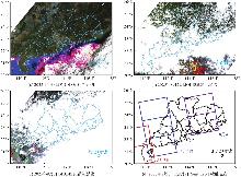
图1
非暴雨期和暴雨期MODIS光学影像和暴雨期间Sentinel-1观测足迹"
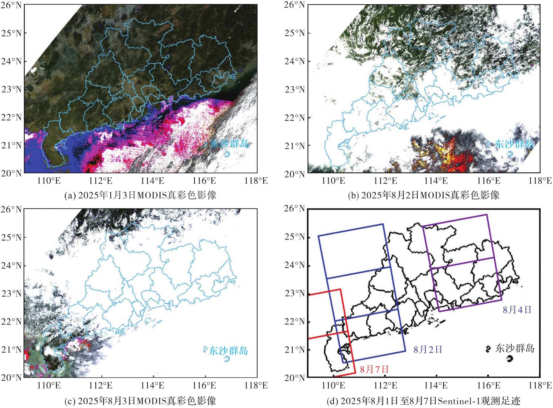
图2
广东省地图和本次暴雨影响最严重的城市"
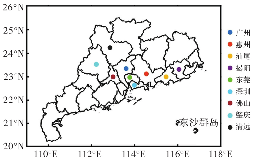
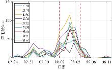
图3
2025年7月24日至8月12日各城市逐日降雨时间序列"
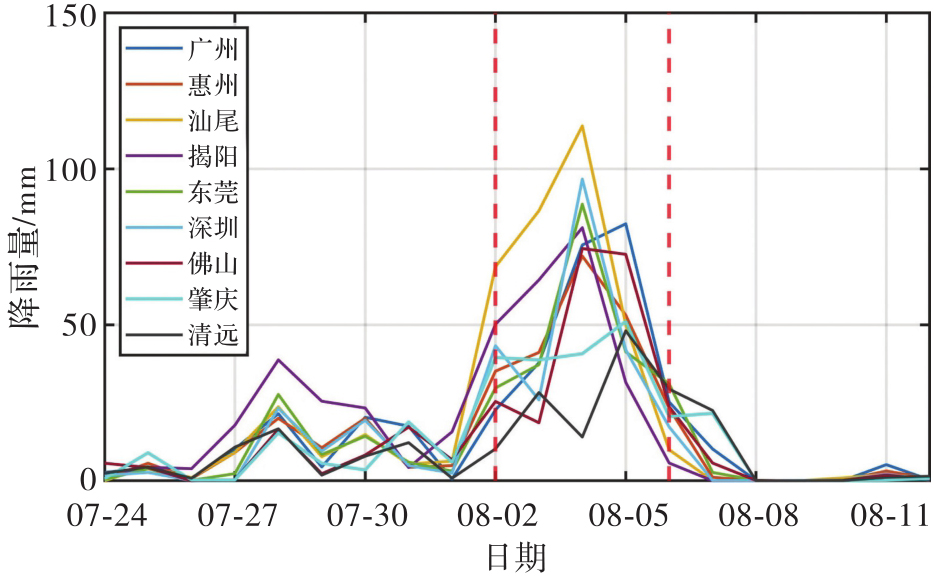
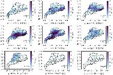
图4
2025年8月1日至8月9日广东降雨空间分布"
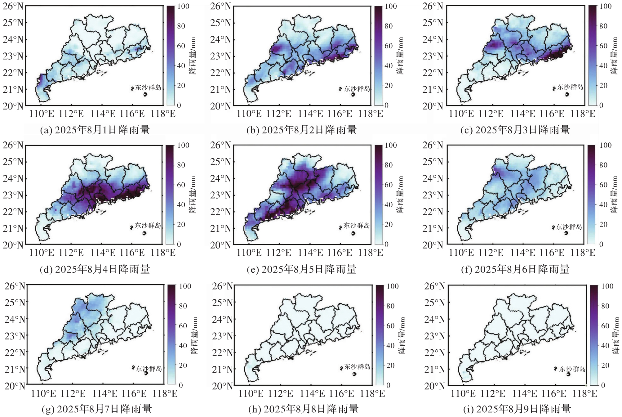
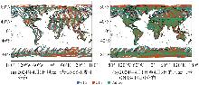
图5
风云三号GNSS-R观测分布"
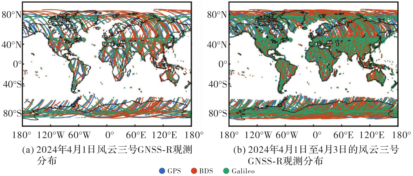
图6
GSWE地表水季节性"
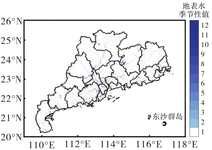
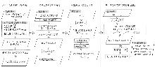
图7
总体技术路线"
表1
GNOS-ⅡGNSS-R线性校准模型"
| 校准系数 | 斜率 | 截距(b) |
|---|---|---|
| GPS | 1.075 | 0.94 |
| BDS | 1 | 0 |
| Galileo | 1 | 0.34 |
图8
洪涝前后SMAP土壤湿度变化及SMAP探测到的淹没范围"

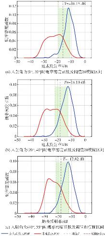
图9
不同入射角分组下永久淹没区和非淹没区的PDF及阈值和模糊区间"
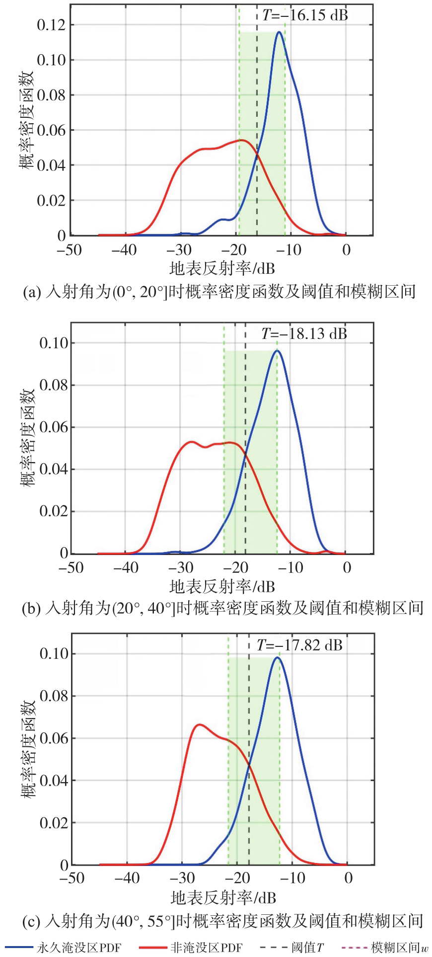
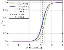
图10
不同入射角分组下SR和Pwater的Sigmoid曲线"
图11
风云三号GNSS-R及CYGNSS地表水探测结果"
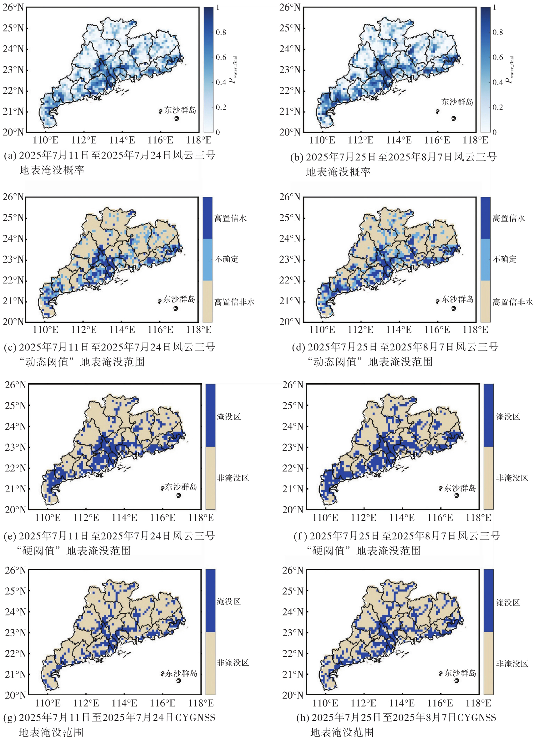
表2
风云三号GNSS-R硬阈值洪涝反演结果混淆矩阵与总体精度"
| 硬阈值法 | 风云三号结果 | CYGNSS参考地表水 | 总体精度 | |
|---|---|---|---|---|
| 非淹没区 | 淹没区 | |||
| 洪涝前 | 非淹没区 | 64.57 | 14.03 | 81.10 |
| 淹没区 | 4.87 | 16.53 | ||
| 洪涝后 | 非淹没区 | 57.85 | 13.84 | 79.63 |
| 淹没区 | 6.53 | 21.78 | ||
表3
风云三号GNSS-R动态阈值洪涝反演结果混淆矩阵与总体精度"
| 动态阈值法 | 风云三号结果 | CYGNSS参考地表水 | 总体精度 | |
|---|---|---|---|---|
| 非淹没区 | 淹没区 | |||
| 洪涝前 | 高置信非水区 | 75.17 | 1.98 | 91.48 |
| 高置信水区 | 6.54 | 16.31 | ||
| 洪涝后 | 高置信非水区 | 68.15 | 1.93 | 90.59 |
| 高置信水区 | 7.48 | 22.44 | ||
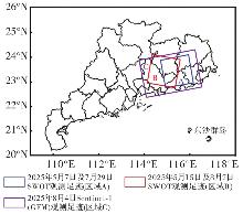
图12
本文使用的SWOT和GFM(Sentinel-1)观测足迹"
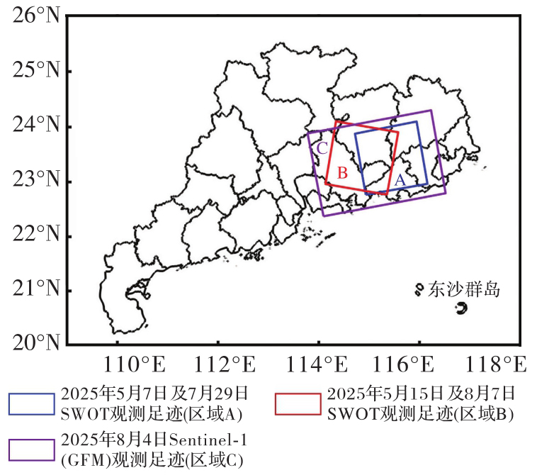
图13
洪涝前后区域A和区域B SWOT地表水面积变化"
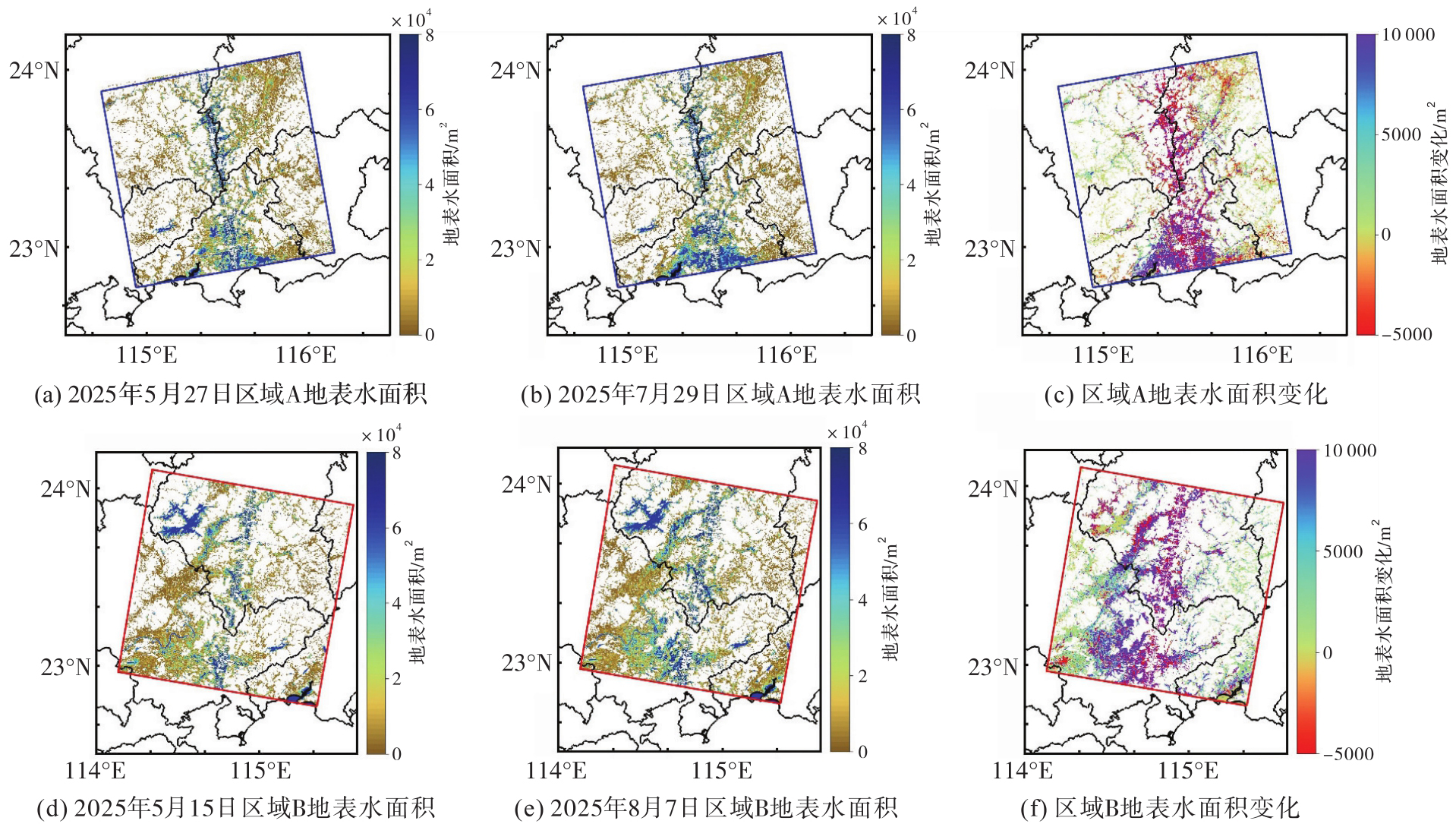
图14
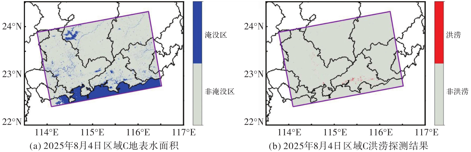
洪涝后区域C GFM地表水分布和洪涝探测结果"
| [1] | BRIVIO P A, COLOMBO R, MAGGI M, et al. Integration of remote sensing data and GIS for accurate mapping of flooded areas[J]. International Journal of Remote Sensing, 2002, 23(3): 429-441. |
| [2] | RAHMAN M S, DI Liping. The state of the art of spaceborne remote sensing in flood management[J]. Natural Hazards, 2017, 85(2): 1223-1248. |
| [3] | DEVRIES B, HUANG Chengquan, ARMSTON J, et al. Rapid and robust monitoring of flood events using Sentinel-1 and Landsat data on the Google Earth Engine[J]. Remote Sensing of Environment, 2020, 240: 111664. |
| [4] | HOSSAIN F, ANAGNOSTOU E N. Assessment of current passive-microwave-and infrared-based satellite rainfall remote sensing for flood prediction[J]. Journal of Geophysical Research: Atmospheres, 2004, 109(D7): 2003JD003986. |
| [5] | 刘经南, 邵连军, 张训械. GNSS-R研究进展及其关键技术[J]. 武汉大学学报(信息科学版), 2007, 32(11): 955-960. |
| LIU Jingnan, SHAO Lianjun, ZHANG Xunxie. Advances in GNSS-R studies and key technologies[J]. Geomatics and Information Science of Wuhan University, 2007, 32(11): 955-960. | |
| [6] | 李黄, 夏青, 尹聪, 等. 我国GNSS-R遥感技术的研究现状与未来发展趋势[J]. 雷达学报(中英文), 2013, 2(4): 389-399. |
| LI Huang, XIA Qing, YIN Cong, et al. The current status of research on GNSS-R remote sensing technology in China and future development[J]. Journal of Radars, 2013, 2(4): 389-399. | |
| [7] | 万玮, 陈秀万, 彭学峰, 等. GNSS遥感研究与应用进展和展望[J]. 遥感学报, 2016, 20(5): 858-874. |
| WAN Wei, CHEN Xiuwan, PENG Xuefeng, et al. Overview and outlook of GNSS remote sensing technology and applications[J]. Journal of Remote Sensing, 2016, 20(5): 858-874. | |
| [8] |
金双根, 张勤耘, 钱晓东. 全球导航卫星系统反射测量(GNSS+R)最新进展与应用前景[J]. 测绘学报, 2017, 46(10): 1389-1398. DOI: .
doi: 10.11947/j.AGCS.2017.20170282 |
|
JIN Shuanggen, ZHANG Qinyun, QIAN Xiaodong. New progress and application prospects of global navigation satellite system reflectometry (GNSS+R)[J]. Acta Geodaetica et Cartographica Sinica, 2017, 46(10): 1389-1398. DOI: .
doi: 10.11947/j.AGCS.2017.20170282 |
|
| [9] | 吴学睿, 宋少辉, 马文骁, 等. 典型水循环参数星载GNSS-R/SoOP-R遥感探测的研究现状[J]. 武汉大学学报(信息科学版), 2024, 49(1): 1-14. |
| WU Xuerui, SONG Shaohui, MA Wenxiao, et al. A review of GNSS-R/SoOP-R for essential hydrological climate variables detection[J]. Geomatics and Information Science of Wuhan University, 2024, 49(1): 1-14. | |
| [10] | UNWIN M, JALES P, TYE J, et al. Spaceborne GNSS-reflectometry on TechDemoSat-1: early mission operations and exploitation[J]. IEEE Journal of Selected Topics in Applied Earth Observations and Remote Sensing, 2016, 9(10): 4525-4539. |
| [11] | RUF C S, ATLAS R, CHANG P S, et al. New ocean winds satellite mission to probe hurricanes and tropical convection[J]. Bulletin of the American Meteorological Society, 2016, 97(3): 385-395. |
| [12] | CAMPS A, MUNOZ-MARTIN J F, RUIZ-DE-AZUA J A, et al. FSSCat: The Federated Satellite Systems 3Cat Mission: demonstrating the capabilities of CubeSats to monitor essential climate variables of the water cycle [Instruments and Missions][J]. IEEE Geoscience and Remote Sensing Magazine, 2022, 10(4): 260-269. |
| [13] | JING Cheng, LI Weiqiang, WAN Wei, et al. A review of the BuFeng-1 GNSS-R mission: calibration and validation results of sea surface and land surface[J]. Geo-spatial Information Science, 2024, 27(3): 638-652. |
| [14] | 王峰, 李建强, 杨东凯, 等. “吉林一号”宽幅01B卫星GNSS-R数据风速反演研究[J]. 武汉大学学报(信息科学版), 2024, 49(1): 56-67. |
| WANG Feng, LI Jianqiang, YANG Dongkai, et al. Wind speed retrieval using GNSS-R data from “Jilin-1” kuanfu-01B satellite[J]. Geomatics and Information Science of Wuhan University, 2024, 49(1): 56-67. | |
| [15] | HUANG Feixiong, YIN Cong, LIU Yan, et al. Tianmu-1 constellation GNSS-R in-orbit performance: spatiotemporal characteristics, product applications, and polarimetric features[J]. IEEE Transactions on Geoscience and Remote Sensing, 2025, 63: 5802020. |
| [16] | YANG Guanglin, BAI Weihua, WANG Jinsong, et al. FY3E GNOS II GNSS reflectometry: mission review and first results[J]. Remote Sensing, 2022, 14(4): 988. |
| [17] | SUN Yueqiang, HUANG Feixiong, XIA Junming, et al. GNOS-II on Fengyun-3 satellite series: exploration of multi-GNSS reflection signals for operational applications[J]. Remote Sensing, 2023, 15(24): 5756. |
| [18] | LI Weiqiang, CARDELLACH E, FABRA F, et al. Assessment of spaceborne GNSS-R ocean altimetry performance using CYGNSS mission raw data[J]. IEEE Transactions on Geoscience and Remote Sensing, 2020, 58(1): 238-250. |
| [19] |
宋敏峰, 何秀凤, 王笑蕾, 等. 顾及地球曲率及椭球高的GNSS-R几何计算方法[J]. 测绘学报, 2023, 52(6): 884-894. DOI: .
doi: 10.11947/j.AGCS.2023.20210563 |
|
SONG Minfeng, HE Xiufeng, WANG Xiaolei, et al. A GNSS-R geometry computation method considering the Earth's curvature and ellipsoidal height[J]. Acta Geodaetica et Cartographica Sinica, 2023, 52(6): 884-894. DOI: .
doi: 10.11947/j.AGCS.2023.20210563 |
|
| [20] |
布金伟, 余科根, 汪秋兰, 等. 融合星载GNSS-R数据和多变量参数全球海洋有效波高深度学习反演法[J]. 测绘学报, 2024, 53(7): 1321-1335. DOI: .
doi: 10.11947/j.AGCS.2024.20230050 |
|
BU Jinwei, YU Kegen, WANG Qiulan, et al. Deep learning retrieval method for global ocean significant wave height by integrating spaceborne GNSS-R data and multivariable parameters[J]. Acta Geodaetica et Cartographica Sinica, 2024, 53(7): 1321-1335. DOI: .
doi: 10.11947/j.AGCS.2024.20230050 |
|
| [21] |
陶庭叶, 李江洋, 朱勇超, 等. 阶段模型修正的星载GNSS-R土壤湿度反演方法[J]. 测绘学报, 2022, 51(9): 1942-1950. DOI: .
doi: 10.11947/j.AGCS.2022.20210026 |
|
TAO Tingye, LI Jiangyang, ZHU Yongchao, et al. Spaceborne GNSS-R for retrieving soil moisture based on the correction of stage model[J]. Acta Geodaetica et Cartographica Sinica, 2022, 51(9): 1942-1950. DOI: .
doi: 10.11947/j.AGCS.2022.20210026 |
|
| [22] | 张双成, 郭沁雨, 马中民, 等. 星载GNSS-R反演土壤湿度研究进展与思考[J]. 武汉大学学报(信息科学版), 2024, 49(1): 15-26. |
| ZHANG Shuangcheng, GUO Qinyu, MA Zhongmin, et al. Research advances and some thoughts on soil moisture retrieval by space-borne GNSS-R[J]. Geomatics and Information Science of Wuhan University, 2024, 49(1): 15-26. | |
| [23] |
杨文涛, 郭斐, 张小红, 等. 利用GNSS反射计和SMAP辐射计反演青藏高原土壤湿度和冻融状态[J]. 测绘学报, 2025, 54(4): 725-735. DOI: .
doi: 10.11947/j.AGCS.2025.20240360 |
|
YANG Wentao, GUO Fei, ZHANG Xiaohong, et al. Soil moisture and freeze-thaw map using GNSS reflectometer and SMAP radiometer for Qinghai-Xizang Plateau[J]. Acta Geodaetica et Cartographica Sinica, 2025, 54(4): 725-735. DOI: .
doi: 10.11947/j.AGCS.2025.20240360 |
|
| [24] | CHEW C, REAGER J T, SMALL E. CYGNSS data map flood inundation during the 2017 Atlantic hurricane season[J]. Scientific Reports, 2018, 8(1): 9336. |
| [25] | WAN Wei, LIU Baojian, ZENG Ziyue, et al. Using CYGNSS data to monitor China's flood inundation during typhoon and extreme precipitation events in 2017[J]. Remote Sensing, 2019, 11(7): 854. |
| [26] | 刘奇, 张双成, 南阳, 等. 利用星载GNSS-R相干信号探测南亚洪水[J]. 武汉大学学报(信息科学版), 2021, 46(11): 1641-1648. |
| LIU Qi, ZHANG Shuangcheng, NAN Yang, et al. Flood detection of South Asia using spaceborne GNSS-R coherent signals[J]. Geomatics and Information Science of Wuhan University, 2021, 46(11): 1641-1648. | |
| [27] | ZHANG Shuangcheng, MA Zhongmin, LI Zhenhong, et al. Using CYGNSS data to map flood inundation during the 2021 extreme precipitation in Henan Province, China[J]. Remote Sensing, 2021, 13(24): 5181. |
| [28] | YANG Wentao, GAO Fan, XU Tianhe, et al. Daily flood monitoring based on spaceborne GNSS-R data: a case study on Henan, China[J]. Remote sensing, 2021, 13(22): 4561. |
| [29] | MA Zhongmin, ZHANG Shuangcheng, LIU Qi, et al. Using CYGNSS and L-band radiometer observations to retrieve surface water fraction: a case study of the catastrophic flood of 2022 in Pakistan[J]. IEEE Transactions on Geoscience and Remote Sensing, 2024, 62: 4203117. |
| [30] | MA Zhongmin, ZHANG Shuangcheng, CAMPS A, et al. A fast and efficient method to estimate inland water levels using CYGNSS L1 data and DTMs: application to floods, lakes and reservoirs monitoring[J]. Journal of Hydrology, 2024, 645: 132258. |
| [31] | PEKEL J F, COTTAM A, GORELICK N, et al. High-resolution mapping of global surface water and its long-term changes[J]. Nature, 2016, 540(7633): 418-422. |
| [32] | RAHMAN M S, DI Liping, YU E, et al. Rapid flood progress monitoring in cropland with NASA SMAP[J]. Remote Sensing, 2019, 11(2): 191. |
| [33] | PU Tianjiao, GERLEIN-SAFDI C, XIONG Ying, et al. Berkeley-RWAWC: a new CYGNSS-based watermask unveils unique observations of seasonal dynamics in the tropics[J]. Water Resources Research, 2024, 60(7): e2024WR037060. |
| [34] | MAUBANT L, DODD L, TREGONING P. Assessing the accuracy of SWOT measurements of water bodies in Australia[J]. Geophysical Research Letters, 2025, 52(6): e2024GL114084. |
| [35] | KRULLIKOWSKI C, CHOW C, WIELAND M, et al. Estimating ensemble likelihoods for the sentinel-1-based global flood monitoring product of the copernicus emergency management service[J]. IEEE Journal of Selected Topics in Applied Earth Observations and Remote Sensing, 2023, 16: 6917-6930. |
| [36] | HUFFMAN G J, BOLVIN D T, BRAITHWAITE D, et al. NASA global precipitation measurement (GPM) integrated multi-satellite retrievals for GPM (IMERG)[J]. Algorithm theoretical basis document (ATBD) version, 2015, 4(26): 30. |
| [37] | YANG Guanglin, DU Xiaoyong, HUANG Lingyong, et al. An illustration of FY-3E GNOS-R for global soil moisture monitoring[J]. Sensors, 2023, 23(13): 5825. |
| [38] | YIN Cong, HUANG Feixiong, XIA Junming, et al. Soil moisture retrieval from multi-GNSS reflectometry on FY-3E GNOS-II by land cover classification[J]. Remote Sensing, 2023, 15(4): 1097. |
| [39] | LI Yan, YAN Songhua, GONG Jianya, et al. Soil moisture retrieval by a novel hybrid model based on CYGNSS and sun-induced fluorescence data[J]. Journal of Hydrology, 2024, 632: 130845. |
| [40] | 贾燕, 金双根, 肖智宇, 等. 全球导航卫星系统反射测量土壤水分遥感:现状与机遇[J]. 武汉大学学报(信息科学版), 2023, 48(11): 1784-1799. |
| JIA Yan, JIN Shuanggen, XIAO Zhiyu, et al. Soil moisture remote sensing using global navigation satellite system-reflectometry: current status and opportunity[J]. Geomatics and Information Science of Wuhan University, 2023, 48(11): 1784-1799. | |
| [41] | DOWNS B, KETTNER A J, CHAPMAN B D, et al. Assessing the relative performance of GNSS-R flood extent observations: case study in south Sudan[J]. IEEE Transactions on Geoscience and Remote Sensing, 2023, 61: 4201213. |
| [1] | 布金伟, 刘淑慧, 徐顺双, 向彤粟, 汪秋兰, 籍超颖, 左小清. 星载GNSS-R全球海浪波周期估计的经验模型构建[J]. 测绘学报, 2026, 55(4): 684-697. |
| [2] | 赵庆志, 马智, 姚宜斌, 杜正. GNSS辅助风云三号卫星MERSI近红外通道的大气可降水量反演方法[J]. 测绘学报, 2024, 53(2): 306-320. |
| [3] | 阮仁桂, 贾小林, 冯来平. BDS卫星星内多径及其对宽巷FCB解算的影响分析[J]. 测绘学报, 2017, 46(8): 961-970. |
| [4] | 阚希, 张永宏, 曹庭, 王剑庚, 田伟. 利用多光谱卫星遥感和深度学习方法进行青藏高原积雪判识[J]. 测绘学报, 2016, 45(10): 1210-1221. |
| 阅读次数 | ||||||
|
全文 |
|
|||||
|
摘要 |
|
|||||