


测绘学报 ›› 2024, Vol. 53 ›› Issue (6): 1154-1164.doi: 10.11947/j.AGCS.2024.20230445
孔博( ), 艾廷华(), 杨敏, 吴昊, 余华飞, 肖天元
收稿日期:2023-09-29
发布日期:2024-07-22
通讯作者:
艾廷华
E-mail:bokong@whu.edu.cn;tinghuaai@whu.edu.cn
作者简介:孔博(1998—),男,博士生,研究方向为深度学习下的空间认知。 E-mail:bokong@whu.edu.cn
基金资助:
Bo KONG(), Tinghua AI(), Min YANG, Hao WU, Huafei YU, Tianyuan XIAO
Received:2023-09-29
Published:2024-07-22
Contact:
Tinghua AI
E-mail:bokong@whu.edu.cn;tinghuaai@whu.edu.cn
About author:KONG Bo (1998—), male, PhD candidate, majors in spatial cognition under deep learning. E-mail: bokong@whu.edu.cn
Supported by:摘要:
摘要:地貌类型识别是多因素联合影响下的复杂决策问题。由于地貌区域环境的广泛性、差异性及地学要素作用的复杂性,简单地引入人工智能方法,通过典型样本监督学习并不能获得该问题的满意结果。因此,本文尝试将等高线形态知识这种测绘自然智能与人工智能结合,在地形形态表达规则和典型地貌类型样本训练联合驱动下,开展混合智能下黄土地貌类型识别研究,提出了整合等高线形态知识与带池化操作图神经网络(graph neural network,GNN)的地貌类型识别方法。本文方法将地貌单元的等高线建模为图结构,并将提取的等高线顶点的形态知识嵌入图节点中,采用带池化操作的GNN模型,挖掘图结构中的高层次特征和上下文信息,以识别地貌类型识别。试验结果证明了本文方法在黄土地貌类型识别上的有效性:在测试数据上获得了86.1%的F1值,比两个对比方法高出3.0%~8.2%。
中图分类号:
孔博, 艾廷华, 杨敏, 吴昊, 余华飞, 肖天元. 等高线形态知识与图神经网络联合作用下的黄土地貌类型识别[J]. 测绘学报, 2024, 53(6): 1154-1164.
Bo KONG, Tinghua AI, Min YANG, Hao WU, Huafei YU, Tianyuan XIAO. Identification of loess landform types jointly affected by contour morphological knowledge and the graph neural network[J]. Acta Geodaetica et Cartographica Sinica, 2024, 53(6): 1154-1164.

图1
融合等高线形态知识与图神经网络的地貌类型识别框架"
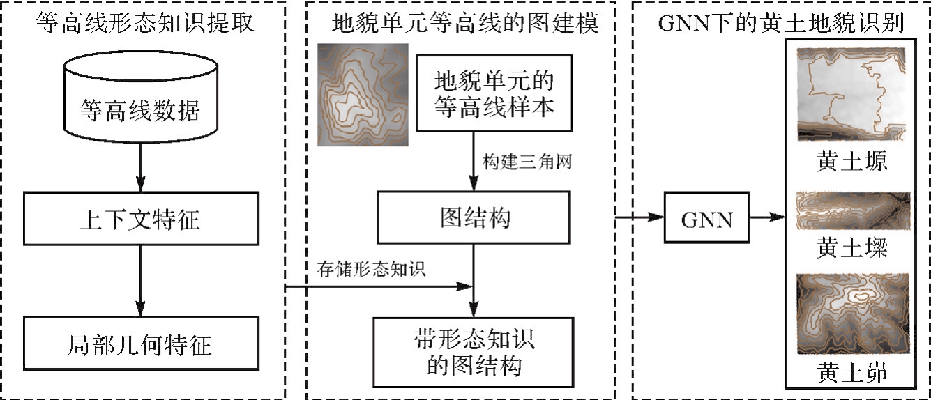
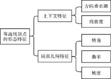
图2
等高线顶点的形态特征"
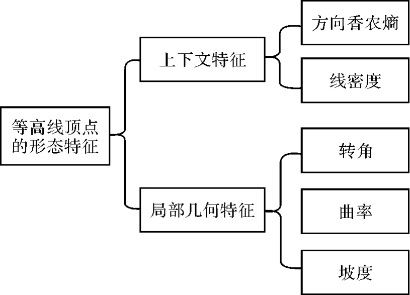

图3
等高线顶点的DSE和CD特征"
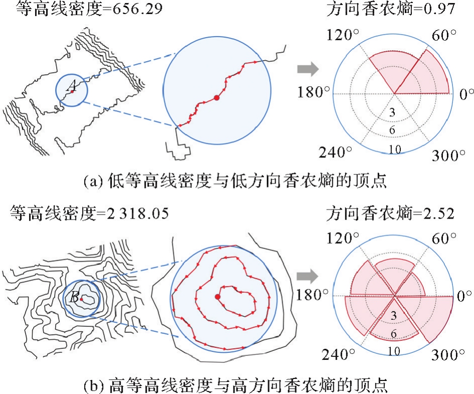
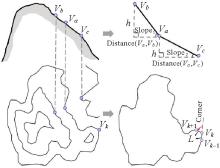
图4
等高线顶点的转角、曲率和坡度计算"

图5
地貌单元等高线图建模"
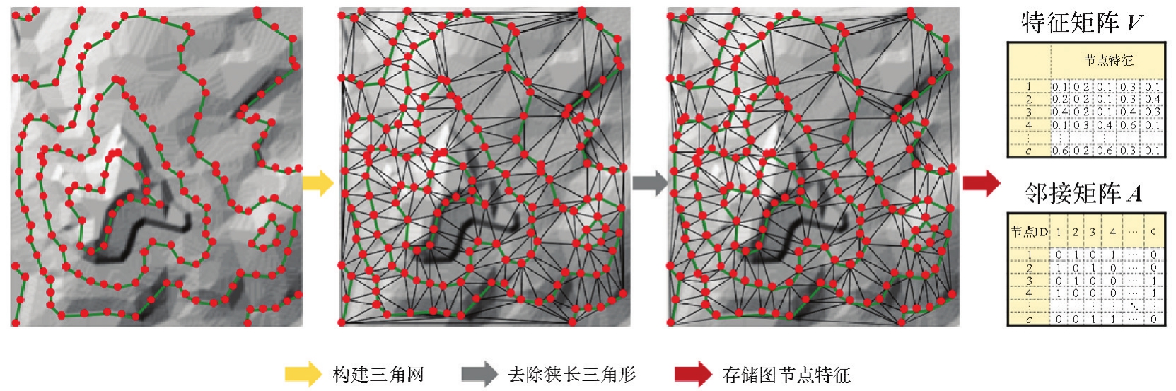
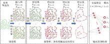
图6
用于黄土地貌类型识别的DGCNN"
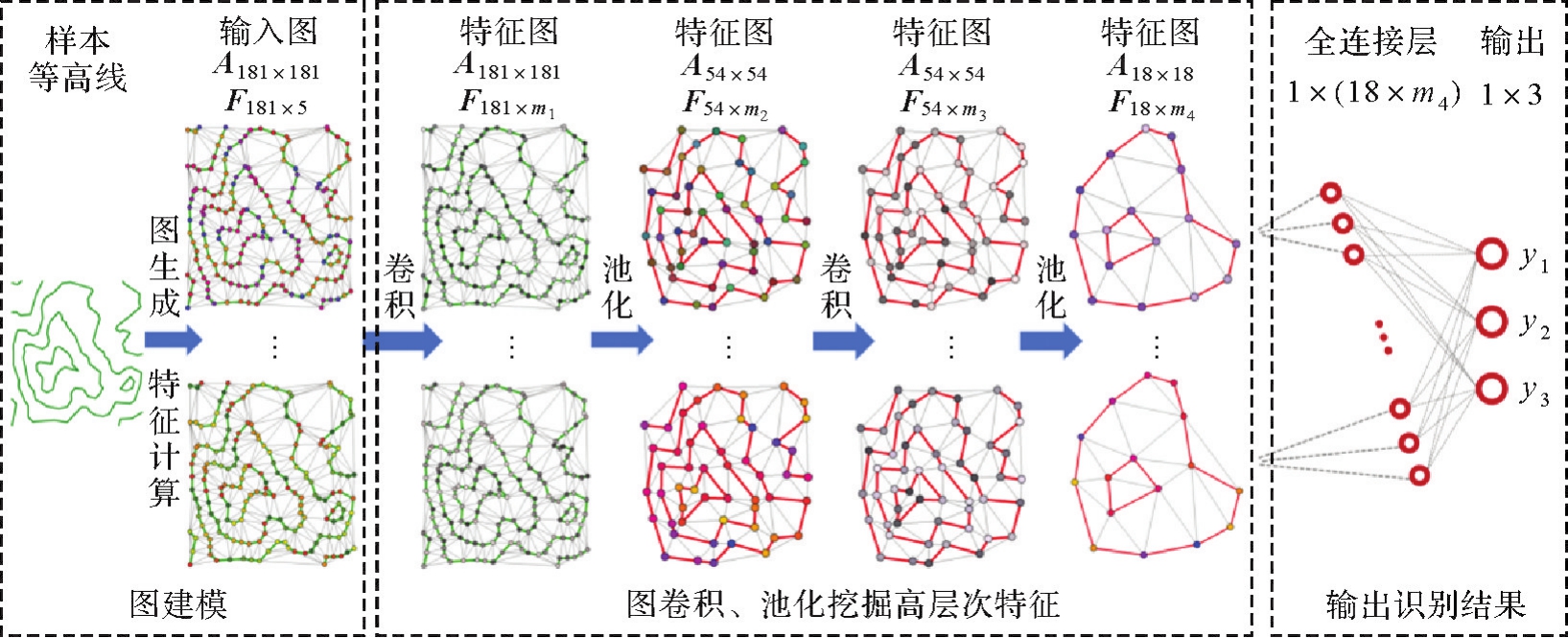
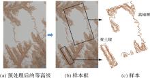
图7
样本构建过程"
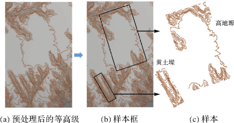
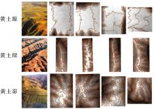
图8
3种典型黄土地貌景观图与示例样本"
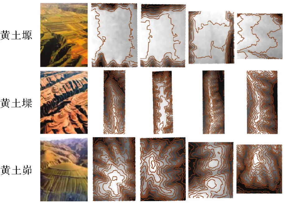
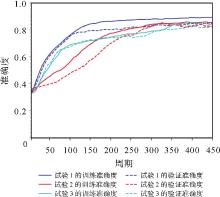
图9
不同训练与验证数据划分比例下的DGCNN模型训练过程中训练与验证准确度的变化情况"

图10
典型测试区域样本的识别结果(数字代表识别为对应类型的概率)"
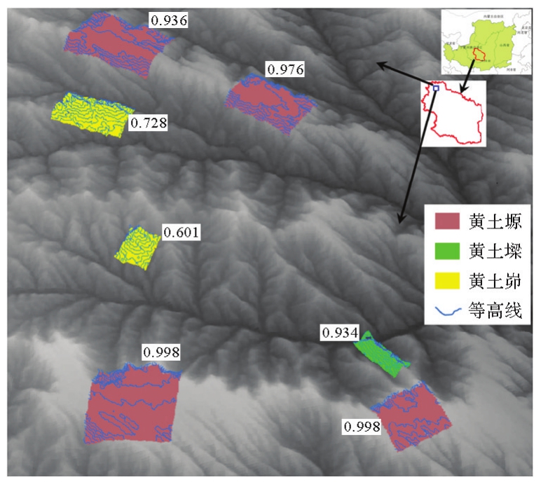
表1
本文方法在测试数据集的混淆矩阵与统计值"
| 标注结果 | 预测结果 | 统计值 | ||||
|---|---|---|---|---|---|---|
| 黄土塬 | 黄土墚 | 黄土峁 | 精确度 | 召回率 | F1值 | |
| 黄土塬 | 154 | 4 | 2 | 89.5 | 96.3 | 92.8 |
| 黄土墚 | 4 | 142 | 14 | 81.1 | 88.8 | 84.8 |
| 黄土峁 | 14 | 29 | 117 | 88.0 | 73.1 | 80.0 |

图11
本文方法主要的错误识别情况"
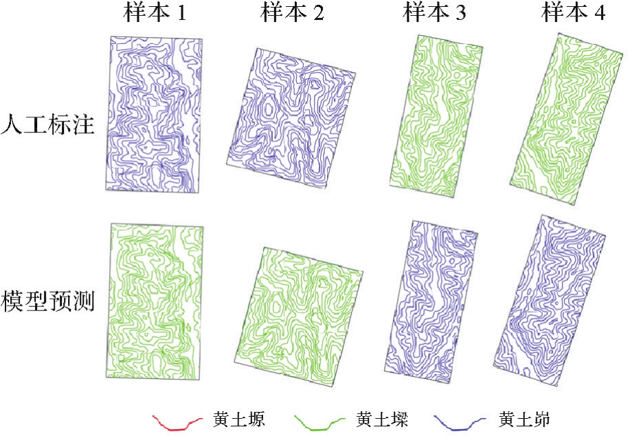
表2
两种对比方法与本文方法在测试数据集的统计值"
| 方法 | 召回率 | 精确度 | F1值 |
|---|---|---|---|
| RF | 75.6 | 80.4 | 77.9 |
| GCNN | 82.1 | 84.2 | 83.1 |
| 本文方法 | 86.0 | 86.2 | 86.1 |
图12
3种方法学习到的黄土地貌高维特征的降维可视化结果"
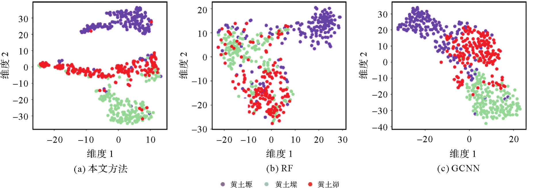
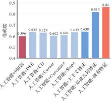
图13
混合智能与人工智能下黄土地貌类型识别方法的测试准确度"

| [1] | OUYANG Shubing, XU Jiahui, CHEN Weitao, et al. A fine-grained genetic landform classification network based on multimodal feature extraction and regional geological context[J]. IEEE Transactions on Geoscience and Remote Sensing, 2022, 60:4511914. |
| [2] | 陈军, 艾廷华, 闫利, 等. 智能化测绘的混合计算范式与方法研究[J/OL]. 测绘学报: 1-19 [2024-04-25]. http://kns.cnki.net/kcms/detail/11.2089.p.20240415.1049002.html. |
| CHEN Jun, AI Tinghua, YAN Li, et al. Hybrid computational paradigm and methods for intelligentized surveying and mapping [J/OL]. Acta Geodaetica et Cartographica Sinica: 1-19 [2024-04-25]. http://kns.cnki.net/kcms/detail/11.2089.p.20240415.1049002.html. | |
| [3] | 陈军, 刘万增, 武昊, 等. 智能化测绘的基本问题与发展方向[J]. 测绘学报, 2021, 50(8):995-1005.DOI:10.11947/j.AGCS.2021.20210235. |
| CHEN Jun, LIU Wanzeng, WU Hao, et al. Smart surveying and mapping: fundamental issues and research agenda[J]. Acta Geodaetica et Cartographica Sinica, 2021, 50(8):995-1005. DOI:10.11947/j.AGCS.2021.20210235. | |
| [4] | 张永生, 张振超, 童晓冲, 等. 地理空间智能研究进展和面临的若干挑战[J]. 测绘学报, 2021, 50(9):1137-1146.DOI:10.11947/j.AGCS.2021.20200420. |
| ZHANG Yongsheng, ZHANG Zhenchao, TONG Xiaochong, et al. Progress and challenges of geospatial artificial intelligence[J]. Acta Geodaetica et Cartographica Sinica, 2021, 50(9):1137-1146. DOI:10.11947/j.AGCS.2021.20200420. | |
| [5] | 张广运, 张荣庭, 戴琼海, 等. 测绘地理信息与人工智能2.0融合发展的方向[J]. 测绘学报, 2021, 50(8):1096-1108. DOI:10.11947/j.AGCS.2021.20210200. |
| ZHANG Guangyun, ZHANG Rongting, DAI Qionghai, et al. The direction of integration surveying and mapping geographic information and artificial intelligence 2.0[J]. Acta Geodaetica et Cartographica Sinica, 2021, 50(8):1096-1108. DOI:10.11947/j.AGCS.2021.20210200. | |
| [6] | WANG Sizhe, LI Wenwen. GeoAI in terrain analysis: enabling multi-source deep learning and data fusion for natural feature detection[J]. Computers, Environment and Urban Systems, 2021, 90:101715. |
| [7] | LIN Siwei, XIE Jing, DENG Jiayin, et al. Landform classification based on landform geospatial structure: a case study on Loess Plateau of China[J]. International Journal of Digital Earth, 2022, 15(1):1125-1148. |
| [8] | LI Wenwen, HSU C Y. Automated terrain feature identification from remote sensing imagery: a deep learning approach[J]. International Journal of Geographical Information Science, 2020, 34(4):637-660. |
| [9] | LI Sijin, XIONG Liyang, TANG Guoan, et al. Deep learning-based approach for landform classification from integrated data sources of digital elevation model and imagery[J]. Geomorphology, 2020, 354:107045. |
| [10] | 周访滨, 邹联华, 刘学军, 等. 栅格DEM微地形分类的卷积神经网络法[J]. 武汉大学学报(信息科学版), 2021, 46(8):1186-1193. |
| ZHOU Fangbin, ZOU Lianhua, LIU Xuejun, et al. Micro landform classification method of grid DEM based on convolutional neural network[J]. Geomatics and Information Science of Wuhan University, 2021, 46(8):1186-1193. | |
| [11] | XIONG Liyang, ZHU Axing, ZHANG Lei, et al. Drainage basin object-based method for regional-scale landform classification: a case study of loess area in China[J]. Physical Geography, 2018, 39(6):1-19. |
| [12] | NA Jiaming, DING Hu, ZHAO Wufan, et al. Object-based large-scale terrain classification combined with segmentation optimization and terrain features: a case study in China[J]. Transactions in GIS, 2021, 25(6):2939-2962. |
| [13] | HUANG Wei, DENG Chengbin, DAY M J. Differentiating tower Karst (Fenglin) and cockpit Karst (Fengcong) using DEM contour, slope, and centroid [J]. Environmental earth sciences, 2014, 72:407-416. |
| [14] | AI Tinghua. The drainage network extraction from contour lines for contour line generalization [J]. ISPRS Journal of Photogrammetry and Remote Sensing, 2007, 62(2):93-103. |
| [15] | CHENG Lu, GUO Qingsheng, FEI Lifan, et al. Multi-criterion methods to extract topographic feature lines from contours on different topographic gradients[J]. International Journal of Geographical Information Science, 2022, 36(8):1629-1651. |
| [16] | 郭庆胜, 杨族桥, 冯科. 基于等高线提取地形特征线的研究[J]. 武汉大学学报(信息科学版), 2008, 33(3):253-256, 301. |
| GUO Qingsheng, YANG Zuqiao, FENG Ke. Extracting topographic characteristic line from contours[J]. Geomatics and Information Science of Wuhan University, 2008, 33(3):253-256, 301. | |
| [17] | 熊汉江, 李秀娟. 一种提取山脊线和山谷线的新方法[J]. 武汉大学学报(信息科学版), 2015, 40(4):498-502, 515. |
| XIONG Hanjiang, LI Xiujuan. A new method to extract terrain feature lines[J]. Geomatics and Information Science of Wuhan University, 2015, 40(4):498-502, 515. | |
| [18] | LECUN Y, BENGIO Y, HINTON G. Deep learning[J]. Nature, 2015, 521(7553):436-444. |
| [19] | LI Wenwen, HSU C Y, HU Maosheng. Tobler's first law in GeoAI: a spatially explicit deep learning model for terrain feature detection under weak supervision[J]. Annals of the American Association of Geographers, 2021, 111(7):1887-1905. |
| [20] | HSU C Y, LI Wenwen, WANG Sizhe. Knowledge-driven GeoAI: integrating spatial knowledge into multi-scale deep learning for Mars Crater detection[J]. Remote Sensing, 2021.13(11), 2116. |
| [21] | JENNY B, HEITZLER M, SINGH D, et al. Cartographic relief shading with neural networks[J]. IEEE Transactions on Visualization and Computer Graphics, 2021, 27(2):1225-1235. |
| [22] | LI Sijin, HU Guanghui, CHENG Xinghua, et al. Integrating topographic knowledge into deep learning for the void-filling of digital elevation models[J]. Remote Sensing of Environment, 2022, 269:112818. |
| [23] | JENNY B. Terrain generalization with line integral convolution[J]. Cartography and Geographic Information Science, 2021, 48(1):78-92. |
| [24] | ZHANG Junxiang, LI Peiran, ZHANG Haoran, et al. Investigation on the relationship between population density and satellite image features: a deep learning based approach[J]. The Journal of Geodesy and Geoinformation Science, 2022, 5(4):50-58. |
| [25] | REICHSTEIN M, CAMPS-VALLS G, STEVENS B, et al. Deep learning and process understanding for data-driven Earth system science [J]. Nature, 2019, 566(7743):195-204. |
| [26] | 王米琪, 艾廷华, 晏雄锋, 等. 图卷积网络模型识别道路正交网格模式[J]. 武汉大学学报(信息科学版), 2020, 45(12):1960-1969. |
| WANG Miqi, AI Tinghua, YAN Xiongfeng, et al. Grid pattern recognition in road networks based on graph convolution network model[J]. Geomatics and Information Science of Wuhan University, 2020, 45(12):1960-1969. | |
| [27] | YAN Xiongfeng, AI Tinghua, YANG Min, et al. A graph convolutional neural network for classification of building patterns using spatial vector data[J]. ISPRS Journal of Photogrammetry and Remote Sensing, 2019, 150:259-273. |
| [28] | YU Huafei, AI Tinghua, YANG Min, et al. A recognition method for drainage patterns using a graph convolutional network[J]. International Journal of Applied Earth Observation and Geoinformation, 2022, 107:102696. |
| [29] | FU Honghao, SHEN Yilang, LIU Yuxuan, et al. SGCN: a multi-order neighborhood feature fusion landform classification method based on superpixel and graph convolutional network[J]. International Journal of Applied Earth Observation and Geoinformation, 2023, 122:103441. |
| [30] | ZHANG Baoyi, LI Manyi, HUAN Yuke, et al. Bedrock mapping based on terrain weighted directed graph convolutional network using stream sediment geochemical samplings[J]. Transactions of Nonferrous Metals Society of China, 2023, 33(9):2299-2814. |
| [31] | 龙毅, 周侗, 汤国安, 等. 典型黄土地貌类型区的地形复杂度分形研究[J]. 山地学报, 2007, 25(4):385-392. |
| LONG Yi, ZHOU Tong, TANG Guoan, et al. Research on terrain complexity of several typical regions of Loess Landform based on fractal method[J]. Journal of Mountain Science, 2007, 25(4):385-392. | |
| [32] | 陈晋北, 陈霄文, 贾伟, 等. 黄土高原塬区近地面层大涡多点观测研究[J]. 中国科学:地球科学, 2023, 53(4):856-865. |
| CHEN Jinbei, CHEN Xiaowen, JIA Wei, et al. Multi-sites observation of large-scale eddy in surface layer of Loess Plateau [J]. Science China Earth Sciences, 2023, 53(4):856-865. | |
| [33] | ZHUANG Jianqi, PENG Jianbing, WANG Gonghui, et al. Distribution and characteristics of landslide in Loess Plateau: a case study in Shaanxi province[J]. Engineering Geology, 2018, 236:89-96. |
| [34] | LI Yanrong, SHI Wenhui, AYDIN A, et al. Loess genesis and worldwide distribution[J]. Earth-Science Reviews, 2020, 201:102947. |
| [35] | 艾廷华. Delaunay三角网支持下的空间场表达[J]. 测绘学报, 2006, 35(1):71-76, 82. |
| AI Tinghua. A spatial field representation model based on Delaunay triangulation[J]. Acta Geodaetica et Cartographica Sinica, 2006, 35(1):71-76, 82. | |
| [36] | 艾廷华, 刘耀林. 保持空间分布特征的群点化简方法[J]. 测绘学报, 2002, 31(2):175-181. |
| AI Tinghua, LIU Yaolin. A method of point cluster simplification with spatial distribution properties preserved[J]. Acta Geodaetica et Cartographic Sinica, 2002, 31(2):175-181. | |
| [37] | YANG Min, KONG Bo, DANG Ruirong, et al. Classifying urban functional regions by integrating buildings and points-of-interest using a stacking ensemble method[J]. International Journal of Applied Earth Observation and Geoinformation, 2022, 108:102753. |
| [38] | 张根寿. 现代地貌学[M]. 北京: 科学出版社, 2005. |
| ZHANG Genshou. Modern geomorphology[M]. Beijing: Science Press, 2005. | |
| [39] | VAN DER MAATEN L, HINTON G. Visualizing data using t-SNE[J]. Journal of Machine Learning Research, 2008, 9:2579-2625. |
| [1] | 禄小敏, 张志义, 闫浩文, 何毅, 苏小宁. 融合深度图信息最大化和多层感知机的建筑物群组模式识别方法[J]. 测绘学报, 2026, 55(3): 425-438. |
| [2] | 张付兵, 孙群, 徐青, 马京振, 黄文君, 陈若虚. 随机森林和图神经网络支持下的河系自动分级与选取方法[J]. 测绘学报, 2025, 54(9): 1697-1711. |
| [3] | 黄哲琨, 钱海忠, 蔡中祥, 王骁, 王俊威, 孔令辉. 基于图神经网络的多尺度网状河系分类匹配方法[J]. 测绘学报, 2025, 54(2): 371-384. |
| [4] | 唐佳怡, 童晓冲, 邱春平, 雷亚现, 雷毅, 宋好帅. 基于场景图的遥感场景检索方法[J]. 测绘学报, 2025, 54(1): 123-135. |
| [5] | 陈占龙, 鲁谢春, 徐永洋. 基于图顶点深度聚类的建筑物合并方法[J]. 测绘学报, 2024, 53(4): 736-749. |
| [6] | 余华飞, 邱天奇, 周哲, 龚冲亚, 肖天元, 杨敏, 艾廷华. 图Transformer支持下的河网模式识别[J]. 测绘学报, 2024, 53(11): 2075-2085. |
| [7] | 罗飘, 许俊奎, 武芳, 吕亚坤, 庄清文. 一种生成式神经网络的道路简化方法[J]. 测绘学报, 2024, 53(10): 2007-2020. |
| [8] | 张云菲, 邱泽航. 利用多层次网眼特征和VAE-PNN模型识别城市道路格网模式[J]. 测绘学报, 2024, 53(1): 189-198. |
| [9] | 王安东, 武芳, 巩现勇, 翟仁健, 刘呈熠, 邱越, 张寒雪. 一种城市路网多层次复合网格模式识别方法[J]. 测绘学报, 2023, 52(11): 1994-2006. |
| [10] | 行瑞星, 武芳, 巩现勇, 杜佳威, 刘呈熠. 建筑群组合直线模式识别的模板匹配方法[J]. 测绘学报, 2021, 50(6): 800-811. |
| [11] | 刘呈熠, 武芳, 巩现勇, 行瑞星, 罗登瀚. 规则池塘群的复杂直线模式识别[J]. 测绘学报, 2020, 49(2): 256-266. |
| [12] | 何海威, 钱海忠, 谢丽敏, 段佩祥. 立交桥识别的CNN卷积神经网络法[J]. 测绘学报, 2018, 47(3): 385-395. |
| [13] | 崔晓杰, 王家耀, 巩现勇, 武芳. 基于改进霍夫变换的环形交叉口识别方法[J]. 测绘学报, 2018, 47(12): 1670-1679. |
| [14] | 巩现勇 武芳. 城市建筑群网格模式的图论识别方法[J]. 测绘学报, 2014, 43(9): 960-968. |
| [15] | 田晶,艾廷华,丁绍军. 基于C4.5算法的道路网网格模式识别[J]. 测绘学报, 2012, 41(1): 121-0. |
| 阅读次数 | ||||||
|
全文 |
|
|||||
|
摘要 |
|
|||||