


测绘学报 ›› 2025, Vol. 54 ›› Issue (2): 321-333.doi: 10.11947/j.AGCS.2025.20240132
于启凡1,2,3( ), 付安民2, 李少宁1(), 刘晓彤2
收稿日期:2024-04-07
出版日期:2025-03-11
发布日期:2025-03-11
通讯作者:
李少宁
E-mail:yqf@mail.hnust.edu.cn;lsn@hnust.edu.cn
作者简介:于启凡(1998—),男,硕士,研究方向为星载激光雷达数据处理。 E-mail:yqf@mail.hnust.edu.cn
基金资助:
Qifan YU1,2,3(), Anmin FU2, Shaoning LI1(), Xiaotong LIU2
Received:2024-04-07
Online:2025-03-11
Published:2025-03-11
Contact:
Shaoning LI
E-mail:yqf@mail.hnust.edu.cn;lsn@hnust.edu.cn
About author:YU Qifan (1998—), male, master, majors in spaceborne LiDAR data processing. E-mail: yqf@mail.hnust.edu.cn
Supported by:摘要:
有效评价卫星激光测高数据的几何定位精度是保障其产品应用的基础和前提。卫星在轨后激光光轴指向和平台稳定会随时间推移发生变化,从而引起激光光斑在地面定位位置出现偏差。本文针对句芒号卫星激光测高系统的工作模式,首先对激光足印相机上的光斑位置和光轴指向进行确定,提出一种基于光斑能量梯度最大的椭圆拟合方法(MG-EFM),分析卫星在轨后激光出射指向的稳定性;再利用高精度地形数据标校激光足印点在地面的位置,对激光几何定位精度进行分析。试验结果表明:①MG-EFM方法提取足印光斑中心的精度优于0.1像素,可用于激光光轴指向的稳定性监测,并对短期内激光光轴的漂移误差进行有效识别;②在东北虎豹国家公园地区句芒号激光几何定位相对稳定,发现随着卫星测量环境和观测时间的不同,激光光斑定位呈现时变性的误差分布特性,尤其是昼夜观测的激光光斑在地面定位存在10 m左右的不一致性。为满足卫星激光测高产品的业务化应用需求,后续应增加地面控制数据来提升产品的几何稳定性。
中图分类号:
于启凡, 付安民, 李少宁, 刘晓彤. 卫星激光测高产品定位精度初步验证与分析[J]. 测绘学报, 2025, 54(2): 321-333.
Qifan YU, Anmin FU, Shaoning LI, Xiaotong LIU. Preliminary verification and analysis of positioning accuracy of the satellite laser altimetry products[J]. Acta Geodaetica et Cartographica Sinica, 2025, 54(2): 321-333.
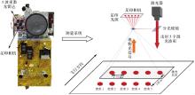
图1
句芒号卫星激光测量系统"

表1
多波束激光雷达主要技术指标"
| 指标 | 设计值 |
|---|---|
| 轨道高度/km | 506 |
| 激光波束数 | 5 |
| 波长/nm | 1064 |
| 发射频率/Hz | 40 |
| 采样频率/GHz | 1.2 |
| 光斑直径/m | 25 |
| 足印影像分辨率/m | 8 |
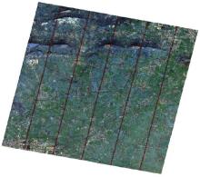
图2
激光数据分布"

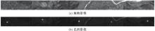
图3
句芒号卫星足印相机影像"
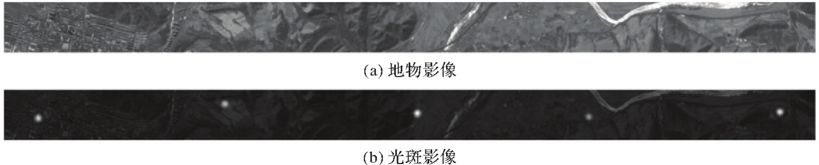

图4
基于光斑能量梯度最大的椭圆拟合方法原理"
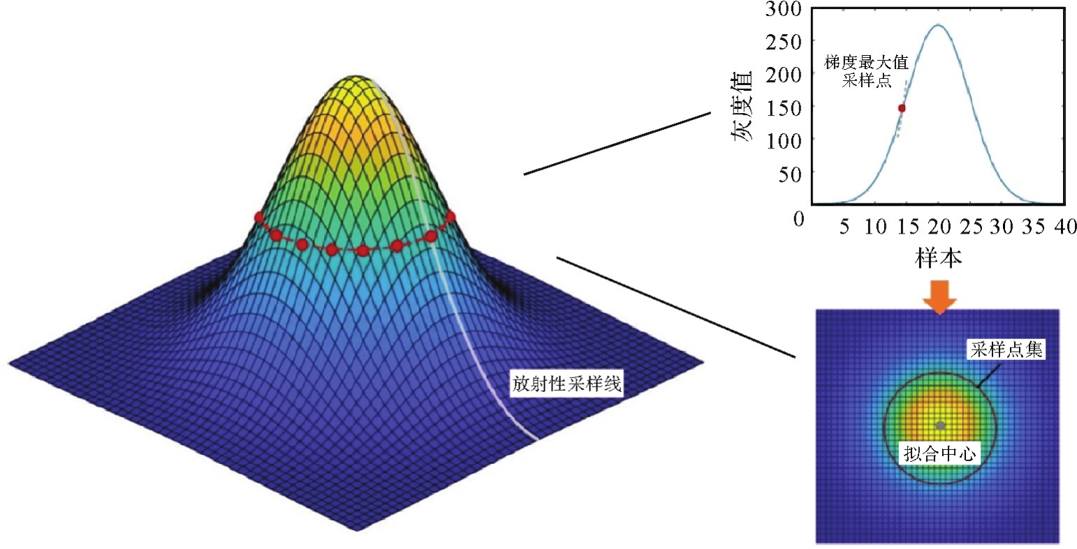
图5
基于地形约束激光足印定位原理"

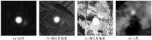
图6
实测光斑影像"


图7
仿真足印影像"

表2
不同方法提取结果"
| 方法 | 平均误差 | 标准差 | 均方根误差 | ||||
|---|---|---|---|---|---|---|---|
| X | Y | X | Y | X | Y | 整体 | |
| GFM | 0.137 | 0.088 | 0.165 | 0.217 | 0.215 | 0.234 | 0.318 |
| GCM | 0.057 | -0.035 | 0.035 | 0.193 | 0.067 | 0.196 | 0.207 |
| MG-EFM | -0.003 | 0.001 | 0.052 | 0.068 | 0.053 | 0.068 | 0.086 |
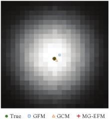
图8
误差对比"
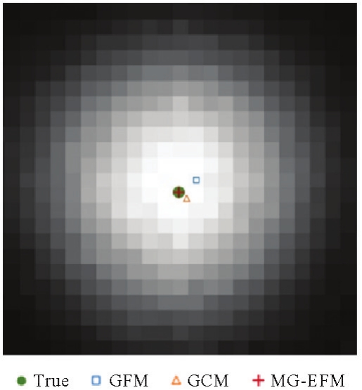
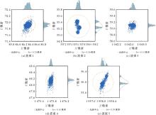
图9
一个轨道周期内5个波束足印光斑中心位置分布注:σ为光斑中心位置分布的标准差。"

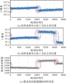
图10
足印光斑中心在X、Y方向上的位置与激光发射能量随时间的变化"

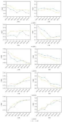
图11
足印光斑中心在X、Y方向上的变化"
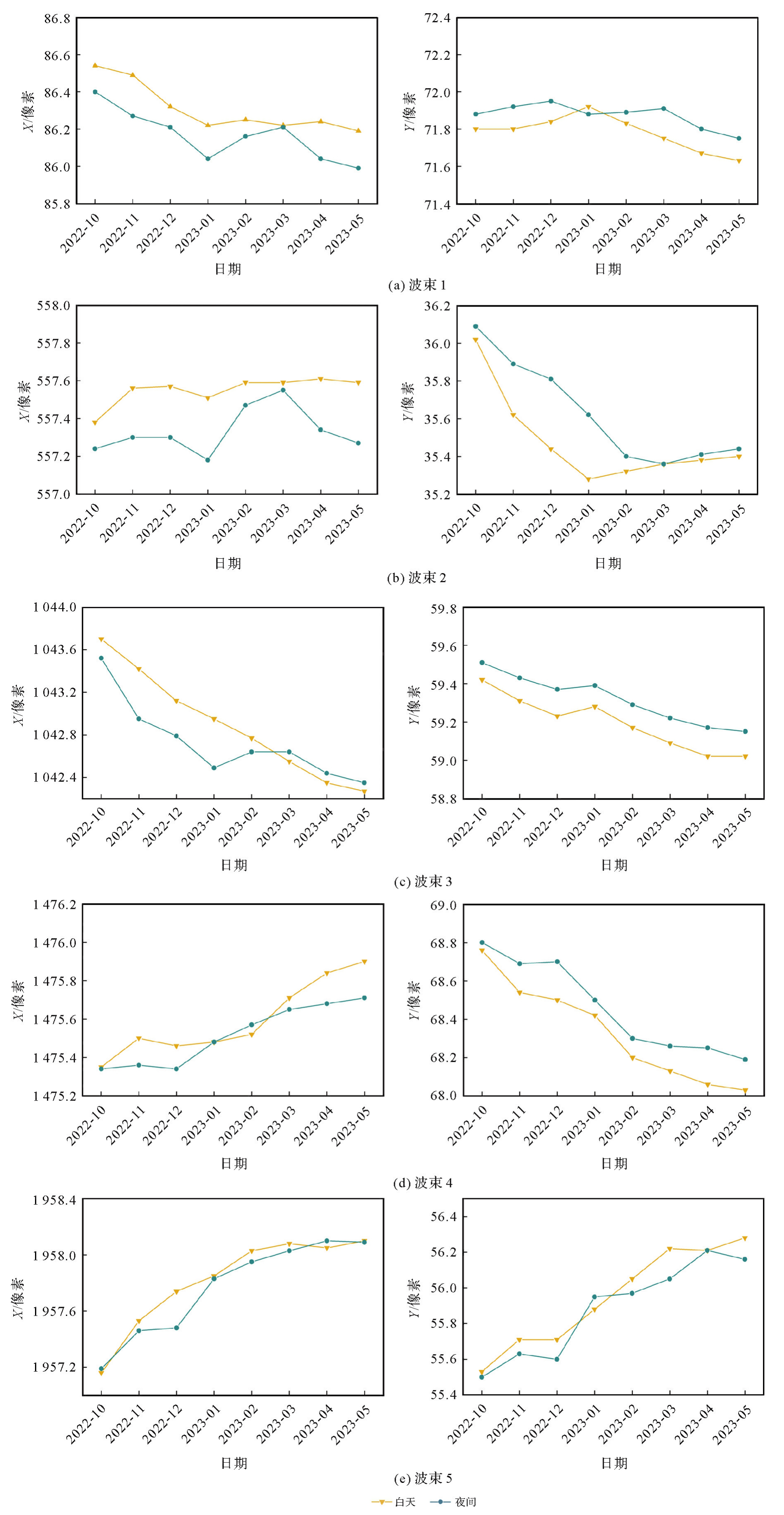
表3
足印光斑中心位置每月统计结果"
| 时段 | 波束 | 极差/像素 | 标准差/像素 | |||
|---|---|---|---|---|---|---|
| X | Y | X | Y | 整体 | ||
| 白天 | 1 | 0.346 | 0.286 | 0.132 | 0.094 | 0.162 |
| 2 | 0.227 | 0.742 | 0.076 | 0.243 | 0.255 | |
| 3 | 1.428 | 0.393 | 0.507 | 0.142 | 0.527 | |
| 4 | 0.547 | 0.730 | 0.197 | 0.263 | 0.329 | |
| 5 | 0.939 | 0.748 | 0.332 | 0.281 | 0.435 | |
| 夜间 | 1 | 0.406 | 0.205 | 0.137 | 0.067 | 0.153 |
| 2 | 0.377 | 0.732 | 0.123 | 0.275 | 0.301 | |
| 3 | 1.168 | 0.358 | 0.373 | 0.129 | 0.395 | |
| 4 | 0.363 | 0.610 | 0.155 | 0.243 | 0.288 | |
| 5 | 0.904 | 0.708 | 0.343 | 0.270 | 0.437 | |

图12
试验区激光数据和DSM数据"
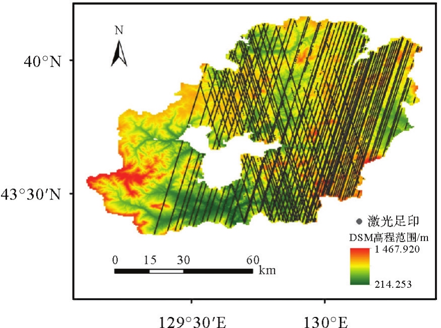
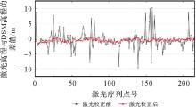
图13
平面位置校正前后激光点高程与DSM高程之间的差值"
表4
句芒号卫星激光几何定位精度验证结果"
| 时段 | 激光波束 | 轨道数 | 激光点数 | 平面定位精度/m | 高程精度(均方根误差)/m | |||
|---|---|---|---|---|---|---|---|---|
| 平均误差 | 标准差 | 中误差 | 校正前 | 校正后 | ||||
| 白天 | 波束1 | 21 | 970 | 14.28 | 2.79 | 14.54 | 2.45 | 1.33 |
| 波束2 | 21 | 1122 | 17.21 | 3.18 | 17.49 | 2.94 | 1.38 | |
| 波束3 | 21 | 1183 | 14.31 | 2.53 | 14.52 | 2.87 | 1.31 | |
| 波束4 | 21 | 1122 | 13.47 | 3.14 | 13.81 | 2.54 | 1.48 | |
| 波束5 | 21 | 1061 | 12.86 | 2.44 | 13.08 | 2.78 | 1.61 | |
| 合计 | 105 | 5458 | 14.43 | 3.16 | 14.76 | 2.73 | 1.42 | |
| 夜间 | 波束1 | 6 | 371 | 23.81 | 3.32 | 24.00 | 3.68 | 1.53 |
| 波束2 | 6 | 455 | 24.74 | 4.18 | 25.03 | 3.87 | 1.39 | |
| 波束3 | 6 | 500 | 22.02 | 4.74 | 22.44 | 3.87 | 1.40 | |
| 波束4 | 6 | 423 | 22.37 | 4.76 | 22.79 | 3.19 | 1.45 | |
| 波束5 | 6 | 424 | 22.69 | 3.91 | 22.97 | 3.58 | 1.31 | |
| 合计 | 30 | 2173 | 23.12 | 4.05 | 23.46 | 3.66 | 1.41 | |
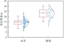
图14
昼夜激光定位误差分布"
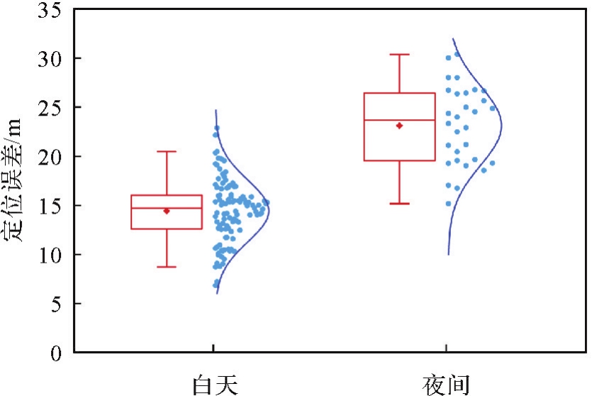
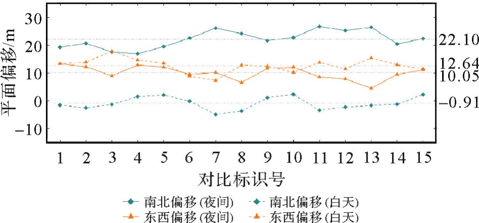
表5
昼夜激光数据在南北(东西)方向上的平面偏移"
| 对比标识号 | 激光波束 | 白天 | 夜间 | ||
|---|---|---|---|---|---|
| 南北偏移/m | 东西偏移/m | 南北偏移/m | 东西偏移/m | ||
| 1 | 波束1 | -1.56 | 13.26 | 19.20 | 13.26 |
| 2 | 波束2 | -2.52 | 13.86 | 20.64 | 12.24 |
| 3 | 波束3 | -1.32 | 17.82 | 17.52 | 8.94 |
| 4 | 波束4 | 1.50 | 14.64 | 16.86 | 12.84 |
| 5 | 波束5 | 2.04 | 13.50 | 19.44 | 12.12 |
| 6 | 波束1 | -0.12 | 8.82 | 22.44 | 9.48 |
| 7 | 波束2 | -4.92 | 7.32 | 26.10 | 10.20 |
| 8 | 波束3 | -3.72 | 12.78 | 24.12 | 6.54 |
| 9 | 波束4 | 1.08 | 12.42 | 21.60 | 11.64 |
| 10 | 波束5 | 2.28 | 10.20 | 22.67 | 12.00 |
| 11 | 波束1 | -3.42 | 13.74 | 26.70 | 8.58 |
| 12 | 波束2 | -2.28 | 11.46 | 25.20 | 7.80 |
| 13 | 波束3 | -1.68 | 15.42 | 26.40 | 4.50 |
| 14 | 波束4 | -1.26 | 12.90 | 20.40 | 9.48 |
| 15 | 波束5 | 2.21 | 11.46 | 22.26 | 11.10 |
| 平均值 | -0.91 | 12.64 | 22.10 | 10.05 | |
| 标准差 | 2.32 | 2.59 | 3.15 | 2.49 | |
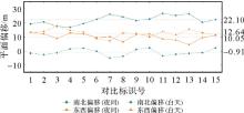
图15
昼夜激光平面偏移对比"
| [1] | 张新伟, 黄缙, 贺涛, 等. 陆地生态系统碳监测卫星总体设计[J]. 航天返回与遥感, 2022, 43(6): 16-26. |
| ZHANG Xinwei, HUANG Jin, HE Tao, et al. Overall design of terrestrial ecosystem carbon inventory satellite[J]. Spacecraft Recovery & Remote Sensing, 2022, 43(6): 16-26. | |
| [2] | WANG Xianwei, CHENG Xiao, GONG Peng, et al. Earth science applications of ICESat/GLAS: a review[J]. International Journal of Remote Sensing, 2011, 32(23): 8837-8864. |
| [3] | DUNCANSON L, KELLNER J R, ARMSTON J, et al. Aboveground biomass density models for NASA's global ecosystem dynamics investigation (GEDI) LiDAR mission[J]. Remote Sensing of Environment, 2022, 270: 112845. |
| [4] |
李国元, 唐新明. 资源三号02星激光测高精度分析与验证[J]. 测绘学报, 2017, 46(12): 1939-1949. DOI:.
doi: 10.11947/j.AGCS.2017.20170174 |
|
LI Guoyuan, TANG Xinming. Analysis and validation of ZY-3 02 satellite laser altimetry data[J]. Acta Geodaetica et Cartographica Sinica, 2017, 46(12): 1939-1949. DOI:.
doi: 10.11947/j.AGCS.2017.20170174 |
|
| [5] | 黄庚华, 丁宇星, 吴金才, 等. 高分七号卫星激光测高仪分系统关键技术设计与实现[J]. 航天器工程, 2020, 29(3): 68-73. |
| HUANG Genghua, DING Yuxing, WU Jincai, et al. Design and implementation of key technology of GF-7 satellite laser altimeter subsystem[J]. Spacecraft Engineering, 2020, 29(3): 68-73. | |
| [6] | 汤天瑾, 杨居奎, 伏瑞敏, 等. 陆地生态系统碳监测卫星多波束激光雷达光学系统设计[J]. 航天返回与遥感, 2022, 43(6): 36-49. |
| TANG Tianjin, YANG Jukui, FU Ruimin, et al. Optical design used in multi-beam LiDAR for monitoring of TECIS[J]. Spacecraft Recovery & Remote Sensing, 2022, 43(6): 36-49. | |
| [7] | 张鑫, 孟俊清, 刘经启, 等. 陆地生态系统碳监测卫星多波束激光雷达激光器设计[J]. 航天返回与遥感, 2022, 43(6): 59-67. |
| ZHANG Xin, MENG Junqing, LIU Jingqi, et al. Design of laser transmitter for terrestrial ecosystem carbon inventory satellite's multi-beam LiDAR[J]. Spacecraft Recovery & Remote Sensing, 2022, 43(6): 59-67. | |
| [8] | 王小燕, 吕争, 李俊杰, 等. 陆地生态系统碳监测卫星句芒号及其应用[J]. 卫星应用, 2023(7): 18-22. |
| WANG Xiaoyan, LÜ Zheng, LI Junjie, et al. Terrestrial ecosystem carbon inventory satellite “Gou Mang” and its applications[J]. Satellite Application, 2023(7): 18-22. | |
| [9] | 曹海翊, 张新伟, 黄缙, 等. 陆地生态系统碳监测卫星系统设计与技术创新[J]. 中国空间科学技术, 2023, 43(6): 112-124. |
| CAO Haiyi, ZHANG Xinwei, HUANG Jin, et al. System design and key technologies of terrestrial ecosystem carbon inventory satellite[J]. Chinese Space Science and Technology, 2023, 43(6): 112-124. | |
| [10] | LUTHCKE S B, ROWLANDS D D, MCCARTHY J J, et al. Spaceborne laser-altimeter-pointing bias calibration from range residual analysis[J]. Journal of Spacecraft and Rockets, 2000, 37(3): 374-384. |
| [11] | LUTHCKE S B, THOMAS T C, PENNINGTON T A, et al. ICESat-2 pointing calibration and geolocation performance[J]. Earth and Space Science, 2021, 8(3): e2020EA001494. |
| [12] | 范春波, 李建成, 王丹, 等. ICESAT/GLAS激光脚点定位及误差分析[J]. 大地测量与地球动力学, 2007, 27(1): 104-106. |
| FAN Chunbo, LI Jiancheng, WANG Dan, et al. ICESAT/GLAS laser footprint geolocation and error analysis[J]. Journal of Geodesy and Geodynamics, 2007, 27(1): 104-106. | |
| [13] | 马跃, 阳凡林, 卢秀山, 等. 对地观测星载激光测高系统高程误差分析[J]. 红外与激光工程, 2015, 44(3): 1042-1047. |
| MA Yue, YANG Fanlin, LU Xiushan, et al. Elevation error analysis of spaceborne laser altimeter for earth observation[J]. Infrared and Laser Engineering, 2015, 44(3): 1042-1047. | |
| [14] |
唐新明, 李国元, 高小明, 等. 卫星激光测高严密几何模型构建及精度初步验证[J]. 测绘学报, 2016, 45(10): 1182-1191. DOI:.
doi: 10.11947/j.AGCS.2016.20150357 |
|
TANG Xinming, LI Guoyuan, GAO Xiaoming, et al. The rigorous geometric model of satellite laser altimeter and preliminarily accuracy validation[J]. Acta Geodaetica et Cartographica Sinica, 2016, 45(10): 1182-1191. DOI:.
doi: 10.11947/j.AGCS.2016.20150357 |
|
| [15] | 唐新明, 陈继溢, 李国元, 等. 资源三号02星激光测高误差分析与指向角粗标定[J]. 武汉大学学报(信息科学版), 2018, 43(11): 1611-1619. |
| TANG Xinming, CHEN Jiyi, LI Guoyuan, et al. Error analysis and preliminary pointing angle calibration of laser altimeter on Ziyuan-3 02 satellite[J]. Geomatics and Information Science of Wuhan University, 2018, 43(11): 1611-1619. | |
| [16] | 王欢, 李松, 周辉. 地球科学激光测高系统大气延迟修正算法[J]. 激光技术, 2007, 31(2): 169-171. |
| WANG Huan, LI Song, ZHOU Hui. Correction of atmosphere delay for geoscience laser altimeter system[J]. Laser Technology, 2007, 31(2): 169-171. | |
| [17] | 张过, 李少宁, 黄文超, 等. 资源三号02星对地激光测高系统几何检校及验证[J]. 武汉大学学报(信息科学版), 2017, 42(11): 1589-1596. |
| ZHANG Guo, LI Shaoning, HUANG Wenchao, et al. Geometric calibration and validation of ZY3-02 satellite laser altimeter system[J]. Geomatics and Information Science of Wuhan University, 2017, 42(11): 1589-1596. | |
| [18] |
唐新明, 谢俊峰, 莫凡, 等. 高分七号卫星双波束激光测高仪在轨几何检校与试验验证[J]. 测绘学报, 2021, 50(3): 384-395. DOI:.
doi: 10.11947/j.AGCS.2021.20200397 |
|
TANG Xinming, XIE Junfeng, MO Fan, et al. GF-7 dual-beam laser altimeter on-orbit geometric calibration and test verification[J]. Acta Geodaetica et Cartographica Sinica, 2021, 50(3): 384-395. DOI:.
doi: 10.11947/j.AGCS.2021.20200397 |
|
| [19] | 伍煜, 王恒, 韩启金, 等. 基于波形匹配的高分七号星载激光测高仪山地区域脚点定位方法研究[J]. 红外与毫米波学报, 2022, 41(6): 1051-1061. |
| WU Yu, WANG Heng, HAN Qijin, et al. A waveform matching-based method of improving laser footprint geolocation for GaoFen-7 spaceborne laser altimeter in mountainous areas[J]. Journal of Infrared and Millimeter Waves, 2022, 41(6): 1051-1061. | |
| [20] | 李国元, 高小明, 陈继溢, 等. 资源三号02星激光测高数据质量分析[J]. 遥感学报, 2019, 23(6): 1159-1166. |
| LI Guoyuan, GAO Xiaoming, CHEN Jiyi, et al. Data quality analysis of ZY-3 02 satellite laser altimeter[J]. National Remote Sensing Bulletin, 2019, 23(6): 1159-1166. | |
| [21] | SCHENK T, CSATHO B, NEUMANN T. Assessment of ICESat-2's horizontal accuracy using precisely surveyed terrains in Mcmurdo Dry Valleys, Antarctica[J]. IEEE Transactions on Geoscience and Remote Sensing, 2022, 60: 1-11. |
| [22] |
杨雄丹, 李国元, 王佩贤, 等. 星载激光光斑影像激光指向变化探测法[J]. 测绘学报, 2020, 49(12): 1591-1599. DOI:.
doi: 10.11947/j.AGCS.2020.201904 |
|
YANG Xiongdan, LI Guoyuan, WANG Peixian, et al. Laser pointing changes detection method for space-borne laser spot image[J]. Acta Geodaetica et Cartographica Sinica, 2020, 49(12): 1591-1599. DOI:.
doi: 10.11947/j.AGCS.2020.201904 |
|
| [23] | 陈新阳, 龙小祥, 李庆鹏, 等. 陆地生态系统碳监测卫星激光数据处理与精度验证[J/OL]. 武汉大学学报(信息科学版). [2024-01-03]. https://doi.org/10.13203/j.whugis20230110. |
| CHEN Xinyang, LONG Xiaoxiang, LI Qingpeng, et al. Data proccing and accuracy verification for laser altimeter of terrestrial ecosystem carbon inventory satellite[J]. Geomatics and Information Science of Wuhan University. [2024-01-03]. https://doi.org/10.13203/j.whugis20230110. | |
| [24] | YAO Jiaqi, LI Guoyuan, CHEN Jiyi, et al. Cloud detection and centroid extraction of laser footprint image of GF-7 satellite laser altimetry[J]. Journal of Geodesy and Geoinformation Science, 2021, 4(3): 1-12. |
| [25] | 王丽丽, 胡中文, 季杭馨. 基于高斯拟合的激光光斑中心定位算法[J]. 应用光学, 2012, 33(5): 985-990. |
| WANG Lili, HU Zhongwen, JI Hangxin. Laser spot center location algorithm based on Gaussian fitting[J]. Journal of Applied Optics, 2012, 33(5): 985-990. | |
| [26] |
袁小棋, 李国元, 唐新明, 等. 星载激光光斑影像质心自动提取方法[J]. 测绘学报, 2018, 47(2): 135-141. DOI:.
doi: 10.11947/j.AGCS.2018.20170517 |
|
YUAN Xiaoqi, LI Guoyuan, TANG Xinming, et al. Centroid automatic extraction of spaceborne laser spot image[J]. Acta Geodaetica et Cartographica Sinica, 2018, 47(2): 135-141. DOI:.
doi: 10.11947/j.AGCS.2018.20170517 |
|
| [27] | LI Shaoning, ZHANG Guo, FAN Xiufang. Rigorous sensor model of Gaofen-7 satellite laser altimeter based on coupled footprint camera[J]. IEEE Journal of Selected Topics in Applied Earth Observations and Remote Sensing, 2023, 16: 1815-1826. |
| [1] | 李真, 郭金运, 孙中苗, 贾永君, 黄令勇, 孙和平. 基于ICESat-2多波束激光测高数据的全球海洋重力异常反演分析[J]. 测绘学报, 2024, 53(2): 252-262. |
| [2] | 单杰, 田祥希, 李爽, 李韧菲. 星载激光测高技术进展[J]. 测绘学报, 2022, 51(6): 964-982. |
| [3] | 李国元, 唐新明, 周晓青, 卢刚, 陈继溢, 黄庚华, 高小明, 刘诏, 欧阳斯达. 高分七号卫星激光测高仪无场几何定标法[J]. 测绘学报, 2022, 51(3): 401-412. |
| [4] | 唐新明, 谢俊峰, 莫凡, 窦显辉, 李新, 李少宁, 李松, 黄庚华, 付兴科, 刘仁, 朱广彬, 欧阳斯达, 唐洪钊, 陈辉. 高分七号卫星双波束激光测高仪在轨几何检校与试验验证[J]. 测绘学报, 2021, 50(3): 384-395. |
| [5] | 李国元, 唐新明, 陈继溢, 么嘉棋, 刘诏, 高小明, 左志强, 周晓青. 高分七号卫星激光测高数据处理与精度初步验证[J]. 测绘学报, 2021, 50(10): 1338-1348. |
| [6] | 杨雄丹, 李国元, 王佩贤, 陈继溢, 莫凡, 么嘉棋, 金泽林. 星载激光光斑影像激光指向变化探测法[J]. 测绘学报, 2020, 49(12): 1591-1599. |
| [7] | 张智宇, 王虹, 张文豪, 黄科, 周辉, 马跃, 李松. 卫星激光测高植被目标回波的半解析仿真模型[J]. 测绘学报, 2018, 47(2): 142-152. |
| [8] | 袁小棋, 李国元, 唐新明, 高小明, 黄庚华, 李野. 星载激光光斑影像质心自动提取方法[J]. 测绘学报, 2018, 47(2): 135-141. |
| [9] | 李国元, 黄佳鹏, 唐新明, 黄庚华, 周世宏, 赵严铭. 距离门宽度对单光子激光测高卫星探测概率及测距精度的影响[J]. 测绘学报, 2018, 47(11): 1487-1494. |
| [10] | 唐新明, 谢俊峰, 莫凡, 朱广彬, 窦显辉, 张强, 李国元, 欧阳斯达. 资源三号02星激光测高仪足印位置预报方法[J]. 测绘学报, 2017, 46(7): 866-873. |
| [11] | 唐新明, 谢俊峰, 付兴科, 莫凡, 李少宁, 窦显辉. 资源三号02星激光测高仪在轨几何检校与试验验证[J]. 测绘学报, 2017, 46(6): 714-723. |
| [12] | 岳春宇, 邢坤, 鲍云飞, 周楠, 何红艳. 以交叉累积剩余熵为准则的星载激光测高仪大光斑波形数据与地形匹配法[J]. 测绘学报, 2017, 46(3): 346-352. |
| [13] | 李国元, 唐新明. 资源三号02星激光测高精度分析与验证[J]. 测绘学报, 2017, 46(12): 1939-1949. |
| [14] | 唐新明, 李国元, 高小明, 陈继溢. 卫星激光测高严密几何模型构建及精度初步验证[J]. 测绘学报, 2016, 45(10): 1182-1191. |
| 阅读次数 | ||||||
|
全文 |
|
|||||
|
摘要 |
|
|||||