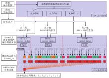
| [1] |
DRANSFIELD M H, CHEN Tianyou. Heli-borne gravity gradiometry in rugged terrain[J]. Geophysical Prospecting, 2019, 67(6): 1626-1636.
|
| [2] |
DRANSFIELD M. Requirements for airborne gravity gradient terrain corrections[J]. ASEG Extended Abstracts, 2010, 2010(1): 1-4.
|
| [3] |
FITZGERALD D, PATERSON R. Getting the best value from gravity gradiometry[J]. ASEG Extended Abstracts, 2013, 2013(1): 1-4.
|
| [4] |
张书航, 庞尹宁, 张吴明, 等. 航空重力梯度标定场无人机精细地形测量[J]. 华中科技大学学报(自然科学版), 2022, 50(9): 76-82.
|
|
ZHANG Shuhang, PANG Yinning, ZHANG Wuming, et al. UAV high-precision topographic mapping of airborne gravity gradient test site[J]. Journal of Huazhong University of Science and Technology (Natural Science Edition), 2022, 50(9): 76-82.
|
| [5] |
EVSTIFEEV M I. The state of the art in the development of onboard gravity gradiometers[J]. Gyroscopy and Navigation, 2017, 8(1): 68-79.
|
| [6] |
GRUJIC M. Data processing requirements for an 1 Eö/√Hz AGG system[J]. ASEG Extended Abstracts, 2012, 2012(1): 1-4.
|
| [7] |
ARAVANIS T, GRUJIC M, PAINE J, et al. High precision terrain corrections for next generation airborne gravity data[J]. ASEG Extended Abstracts, 2015, 2015(1): 1-4.
|
| [8] |
ANNECCHIONE M, HATCH D, HEFFORD S W. DEM sourcing guidelines for computing 1Eö accurate terrain corrections for airborne gravity gradiometry[J]. Journal of Applied Geophysics, 2017, 136: 335-342.
|
| [9] |
HUANG O. Terrain corrections for gravity gradiometry[D]. Columbus: The Ohio State University, 2012.
|
| [10] |
边少锋, 李厚朴. 大地测量计算机代数分析[M]. 北京: 科学出版社, 2018.
|
|
BIAN Shaofeng, LI Houpu. Computer algebra analysis on geodesy[M]. Beijing: Science Press, 2018.
|
| [11] |
KASS M A, LI Yaoguo. Efficient terrain correction in airborne and seaborne gravity gradiometry surveys[J]. ASEG Extended Abstracts, 2007, 2007(1): 1-4.
|
| [12] |
KASS M A, LI Yaoguo. Practical aspects of terrain correction in airborne gravity gradiometry surveys[J]. Exploration Geophysics, 2008, 39(4): 198-203.
|
| [13] |
JEKELI C. Extent and resolution requirements for the residual terrain effect in gravity gradiometry[J]. Geophysical Journal International, 2013, 195(1): 211-221.
|
| [14] |
DRANSFIELD M, ZENG Yi. Airborne gravity gradiometry: terrain corrections and elevation error[J]. Geophysics, 2009, 74(5): 137-142.
|
| [15] |
SIDERIS M G. A fast fourier transform method for computing terrain correction[J]. Manuscripta Geodaetica, 1985, 10: 66-73.
|
| [16] |
FORSBERG R. Gravity field terrain effect computations by FFT[J]. Bulletin Géodésique, 1985, 59(4): 342-360.
|
| [17] |
TZIAVOS I N, SIDERIS M G, FORSBERG R, et al. The effect of the terrain on airborne gravity and gradiometry[J]. Journal of Geophysical Research: Solid Earth, 1988, 93(B8): 9173-9186.
|
| [18] |
PEDERSEN L B, BASTANI M, KAMM J. Gravity gradient and magnetic terrain effects for airborne applications—a practical fast Fourier transform technique[J]. GEOPHYSICS, 2015, 80(2): J19-J26.
|
| [19] |
JEKELI C. A wavelet approach to the terrain correction in gravimetry and gravity gradiometry[J]. GEM-International Journal on Geomathematics, 2012, 3(1): 139-154.
|
| [20] |
DAVIS K, KASS M A, LI Yaoguo. Rapid gravity and gravity gradiometry terrain corrections via an adaptive quadtree mesh discretization[J]. Exploration Geophysics, 2011, 42(1): 88-97.
|
| [21] |
LI Xiong, FOKS L. Gravity and gravity-gradient terrain corrections using an adaptive quadtree-based triangulation technique[C]//Proceedings of 2017 SEG Technical Program Expanded Abstracts. Houston: Society of Exploration Geophysicists, 2017.
|
| [22] |
LI Yaoguo, KASS M A, MARTINEZ C, et al. Practical issues in the processing and inversion of airborne gravity gradiometry data[C]//Proceedings of 2011 International Workshop on Gravity, Electrical & Magnetic Methods and Their Applications. Beijing: Society of Exploration Geophysicists, 2011.
|
| [23] |
MOORKAMP M, JEGEN M, ROBERTS A, et al. Massively parallel forward modeling of scalar and tensor gravimetry data[J]. Computers & Geosciences, 2010, 36(5): 680-686.
|
| [24] |
陈召曦, 孟小红, 郭良辉, 等. 基于GPU并行的重力、重力梯度三维正演快速计算及反演策略[J]. 地球物理学报, 2012, 55(12): 4069-4077.
|
|
CHEN Zhaoxi, MENG Xiaohong, GUO Lianghui, et al. Three-dimensional fast forward modeling and the inversion strategy for large scale gravity and gravimetry data based on GPU[J]. Chinese Journal of Geophysics, 2012, 55(12): 4069-4077.
|
| [25] |
侯振隆. 重力全张量梯度数据的并行反演算法研究及应用[D]. 长春: 吉林大学, 2016.
|
|
HOU Zhenlong. Research and application of parallel inversion algorithm for gravity full tensor gradient data[D]. Changchun: Jilin University, 2016.
|
| [26] |
熊盛青. 航空地球物理综合探测理论技术方法装备应用[M]. 北京: 地质出版社, 2018.
|
|
XIONG Shengqing. Application of theory, technology, method and equipment of aviation geophysical comprehensive detection[M]. Beijing: Geological Publishing House, 2018.
|
| [27] |
黄炎, 王庆宾, 冯进凯, 等. 局部地形改正快速计算的GPU并行的棱柱法[J]. 测绘学报, 2020, 49(11): 1430-1437. DOI: 10.11947/j.AGCS.2020.20190403.
|
|
HUANG Yan, WANG Qingbin, FENG Jinkai, et al. Rapid calcul ation of local topographic correction based on GPU parallel prism method[J]. Acta Geodaetica et Cartographica Sinica, 2020, 49(11): 1430-1437. DOI: 10.11947/j.AGCS.2020.20190403.
|
| [28] |
NAGY D, PAPP G, BENEDEK J. The gravitational potential and its derivatives for the prism[J]. Journal of Geodesy, 2000, 74(7): 552-560.
|
| [29] |
曾华霖. 重力场与重力勘探[M]. 北京: 地质出版社, 2005.
|
|
ZENG Hualin. Gravity field and gravity exploration[M]. Beijing: Geological Publishing House, 2005.
|
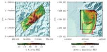
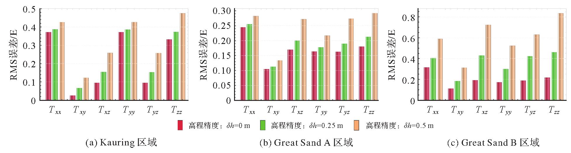
| [30] |
LANE R. Kauring geophysical datasets, August 2010[DB]. Canberra: Geoscience Australia, 2010.
|
| [31] |
DRENTH B, ABRAHAM J, GRAUCH V, et al. Digital data from the great sand dunes airborne gravity gradient survey, south-central Colorado[R]. [S.l.]: U.S. Geological Survey Open-File Report, 2013.
|


 ), 边少锋1,2, 纪兵1(