


测绘学报 ›› 2025, Vol. 54 ›› Issue (3): 510-522.doi: 10.11947/j.AGCS.2025.20240147
高永刚1,2( ), 刘雨婷1, 徐涵秋1,2
收稿日期:2024-04-15
出版日期:2025-04-11
发布日期:2025-04-11
作者简介:高永刚(1976—),男,博士,副教授,研究方向为遥感图像处理与应用。 E-mail:yggao@fzu.edu.cn
基金资助:
Yonggang GAO1,2(), Yuting LIU1, Hanqiu XU1,2
Received:2024-04-15
Online:2025-04-11
Published:2025-04-11
About author:GAO Yonggang (1976—), male, PhD, associate professor, majors in remote sensing image processing and application. E-mail: yggao@fzu.edu.cn
Supported by:摘要:
分析城市生态质量的时空演变及其驱动因素,对区域环境保护与高质量可持续发展至关重要。本文基于多时相Landsat卫星遥感影像及相关辅助数据,利用遥感生态指数(remote sensing ecological index,RSEI),并结合Theil-Sen估计、Mann-Kendall趋势检验、Hurst指数、最优参数地理探测器(optimal parameters-based geographical detectors,OPGD)及多尺度地理加权回归(multi-scale geographically weighted regression,MGWR)模型构建了系统化精细化的城市生态品质评价分析框架。为了验证该框架在快速城市化背景下的适用性和有效性,本文将其用于探究过去20年东莞市的生态质量变化及其影响因素。研究表明:过去20 a间,东莞市生态环境质量经历了恶化-改善-再恶化的复杂动态变化过程。此外,前瞻性预测分析进一步明确了未来生态质量变化的重点区域,并识别出面临严重生态风险及具备较大改善潜力的区域。
中图分类号:
高永刚, 刘雨婷, 徐涵秋. 基于Landsat长时间序列影像的城市生态品质时空演变及驱动因素分析[J]. 测绘学报, 2025, 54(3): 510-522.
Yonggang GAO, Yuting LIU, Hanqiu XU. Analysis of the spatio-temporal evolution and driving factors of urban ecological quality based on long-term Landsat image time series[J]. Acta Geodaetica et Cartographica Sinica, 2025, 54(3): 510-522.
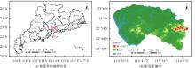
图1
东莞市的地理概况"
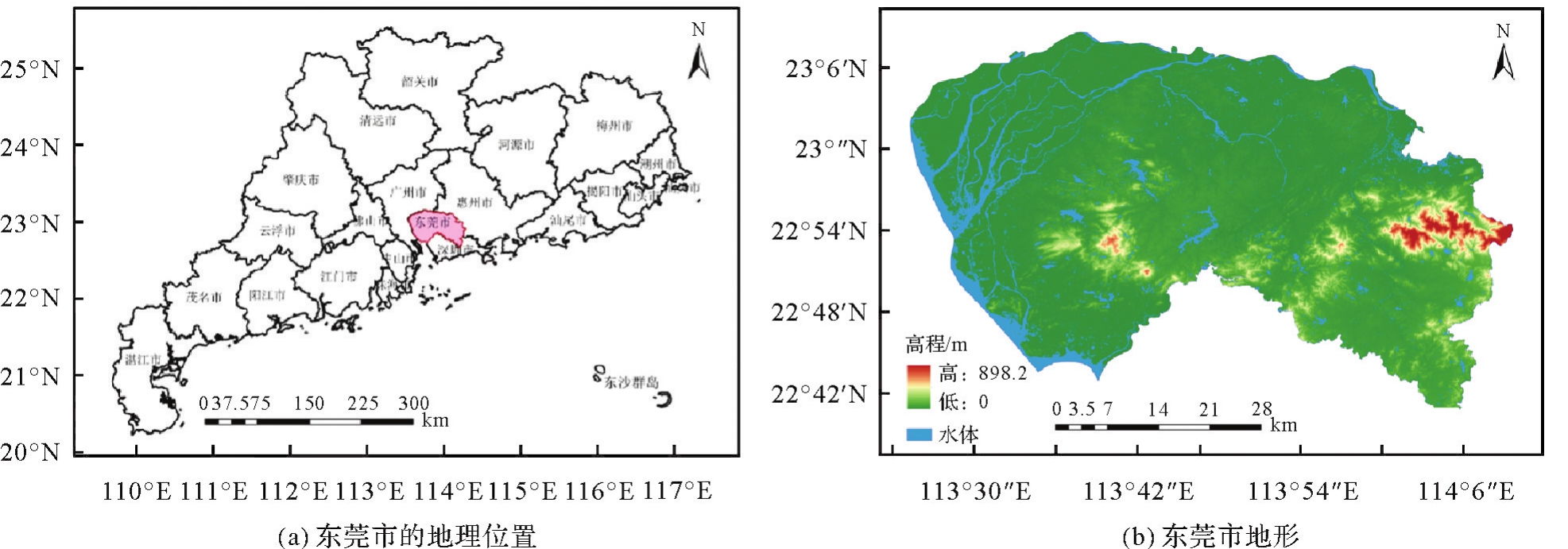
表1
数据源"
| 数据类型 | 分辨率/m | 数据来源 |
|---|---|---|
| Landsat 5 TM(2000—2012年7—8月) Landsat 7 ETM+(2013年7—8月) Landsat 8 OLI(2014—2020年7—8月) | 30 | National Aeronautics and Space Administration(NASA)( |
| temperature(TEMP) precipitation(PREP) | 1000 | China Meteorological Data Service Centre( |
| digital elevation model(DEM)、fractional vegetation cover(FVC) | 30 | Geospatial Data Cloud( |
| land use and land cover change(LUCC) | 30 | Published by Prof. Yang Jie and Huang Xin of Wuhan University( |
| night light intensity data(NLID) | 500 | An extended time-series(2000—2020)of global NPP-VIIRS-like nighttime light data( |
图2
研究技术框架"

表2
2000、2010和2020年的PCA结果"
| 年份 | 指标 | PC1 | PC2 | PC3 | PC4 |
|---|---|---|---|---|---|
| 2000 | NDVI | 0.582 33 | 0.669 79 | 0.075 41 | 0.454 51 |
| WET | 0.398 88 | -0.695 99 | 0.393 17 | 0.449 35 | |
| NDBSI | -0.571 99 | 0.007 56 | -0.285 24 | 0.769 03 | |
| LST | -0.417 87 | 0.258 70 | 0.870 84 | 0.009 66 | |
| 特征值 | 0.235 04 | 0.022 74 | 0.017 24 | 0.001 96 | |
| 贡献率/(%) | 84.859 5 | 8.209 1 | 6.224 1 | 0.707 3 | |
| 2010 | NDVI | 0.563 80 | -0.609 32 | 0.422 26 | 0.364 08 |
| WET | 0.411 54 | 0.742 74 | 0.071 03 | 0.523 38 | |
| NDBSI | -0.572 79 | -0.205 85 | -0.195 31 | 0.769 02 | |
| LST | -0.429 74 | 0.186 24 | 0.882 33 | -0.046 14 | |
| 特征值 | 0.233 04 | 0.023 90 | 0.014 76 | 0.002 21 | |
| 贡献率/(%) | 85.079 1 | 8.72 45 | 5.388 1 | 0.808 3 | |
| 2020 | NDVI | 0.483 63 | -0.735 42 | -0.234 80 | -0.412 47 |
| WET | 0.427 41 | 0.671 25 | -0.26870 | -0.542 71 | |
| NDBSI | -0.627 27 | -0.086 34 | 0.259 41 | -0.729 23 | |
| LST | -0.435 83 | -0.033 53 | -0.897 43 | 0.059 62 | |
| 特征值 | 0.173 97 | 0.034 36 | 0.017 09 | 0.002 48 | |
| 贡献率/(%) | 76.335 4 | 15.078 8 | 7.498 9 | 1.087 0 |
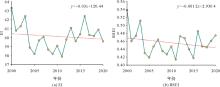
图3
2000—2020年东莞市年均RSEI和EI变化"
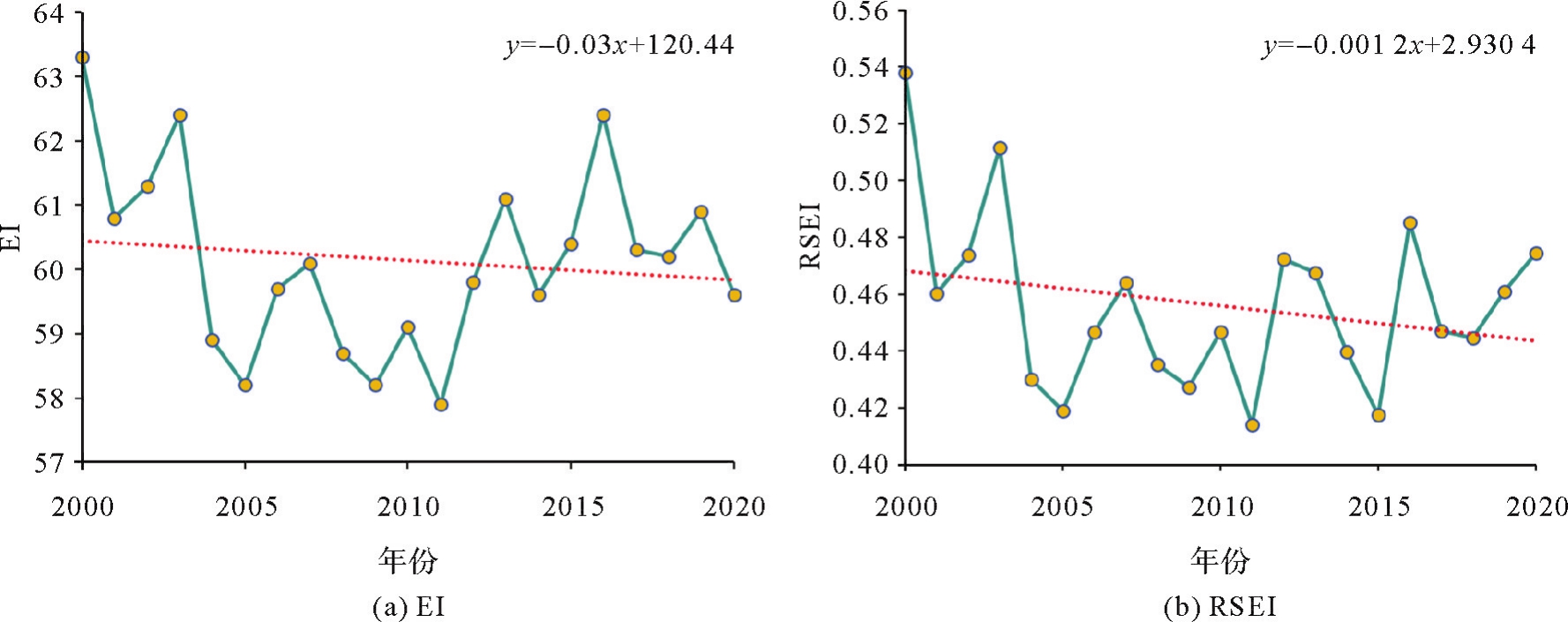
表3
2000—2020年东莞市年均RSEI和EI值"
| 年份 | RSEI | EI | 年份 | RSEI | EI |
|---|---|---|---|---|---|
| 2000 | 0.538 | 63.3 | 2011 | 0.414 | 57.9 |
| 2001 | 0.460 | 60.8 | 2012 | 0.472 | 59.8 |
| 2002 | 0.474 | 61.3 | 2013 | 0.467 | 61.1 |
| 2003 | 0.511 | 62.4 | 2014 | 0.439 | 59.6 |
| 2004 | 0.430 | 58.9 | 2015 | 0.417 | 60.4 |
| 2005 | 0.419 | 58.2 | 2016 | 0.485 | 62.4 |
| 2006 | 0.446 | 59.7 | 2017 | 0.447 | 60.3 |
| 2007 | 0.463 | 60.1 | 2018 | 0.444 | 60.2 |
| 2008 | 0.435 | 58.7 | 2019 | 0.461 | 60.9 |
| 2009 | 0.427 | 59.4 | 2020 | 0.474 | 59.6 |
| 2010 | 0.447 | 60.8 |
图4
2000—2020年东莞市生态质量等级变化"
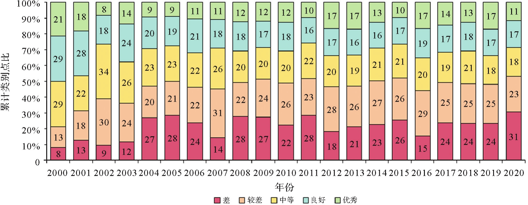
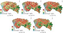
图5
2000年、2005年、2010年、2015年和2020年东莞市RSEI空间分布"
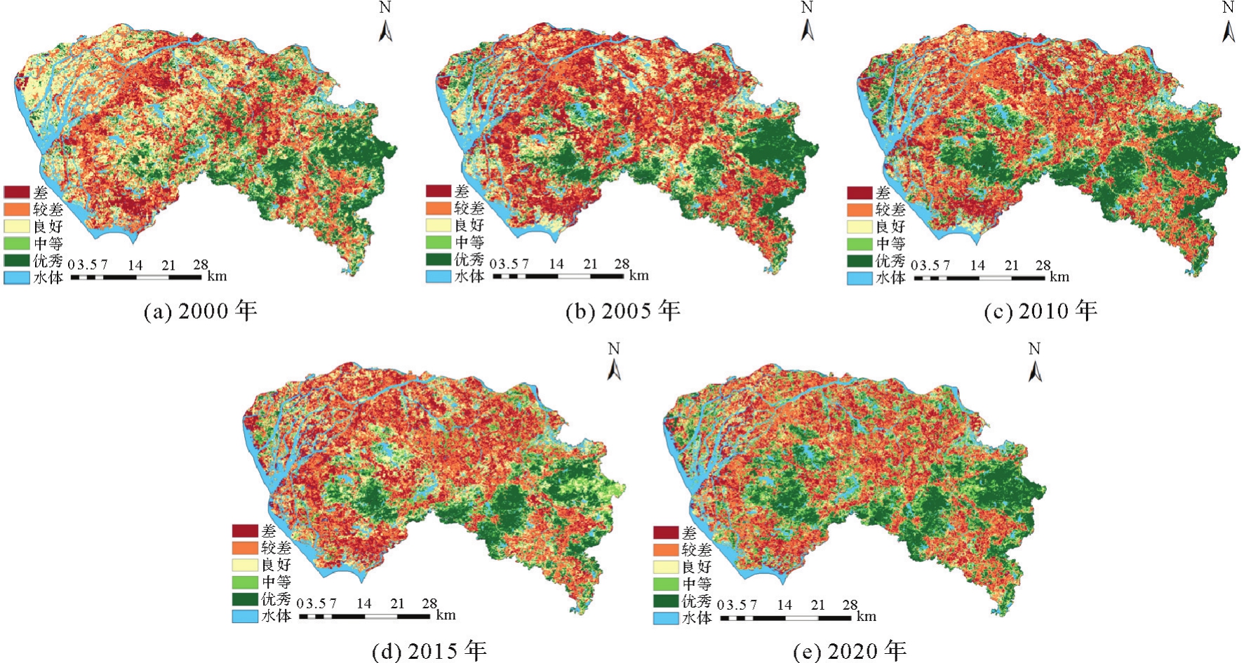
表4
2000—2020年东莞市RSEI变化趋势分类"
| β | z | 趋势 | 面积/km2 | 百分比/(%) |
|---|---|---|---|---|
| ≥0.000 5 | ≥1.96 | 显著增加 | 41.092 | 1.7 |
| ≥0.000 5 | -1.96≤z<1.96 | 没有显著增加 | 611.516 | 25.2 |
| -0.000 5~0.000 5 | -1.96<z<1.96 | 无重大变化 | 491.955 | 20.3 |
| ≤-0.000 5 | -1.96<z≤1.96 | 无显著退化 | 687.464 | 28.3 |
| ≤-0.000 5 | ≤-1.96 | 显著退化 | 594.231 | 24.5 |
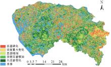
图6
2000—2020年东莞市RSEI变化趋势分级"

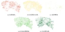
图7
2000—2020年东莞市RSEI变化趋势"

表5
东莞市RSEI变化的可持续性分级"
| Hurst值 | β | 未来变化 | 面积/km2 | 百分比/(%) |
|---|---|---|---|---|
| <0.5 | ≤-0.000 5 | 未来改进 | 18.153 | 0.7 |
| <0.5 | -0.000 5<β<0.000 5 | 随机变化 | 429.782 | 17.7 |
| <0.5 | ≥-0.000 5 | 未来退化 | 740.072 | 30.5 |
| >0.5 | ≤-0.000 5 | 持续退化 | 524.012 | 21.6 |
| >0.5 | -0.000 5<β<0.000 5 | 持续不变 | 666.527 | 27.5 |
| >0.5 | ≥0.000 5 | 持续改进 | 47.753 1 | 2.0 |
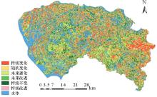
图8
东莞市未来生态质量变化分级"
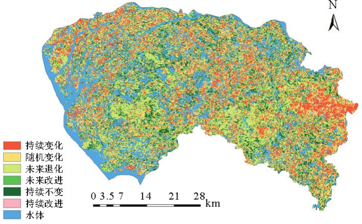

图9
东莞市未来生态质量变化"
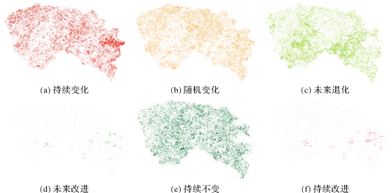
图10
各个因子与RSEI的相关关系"
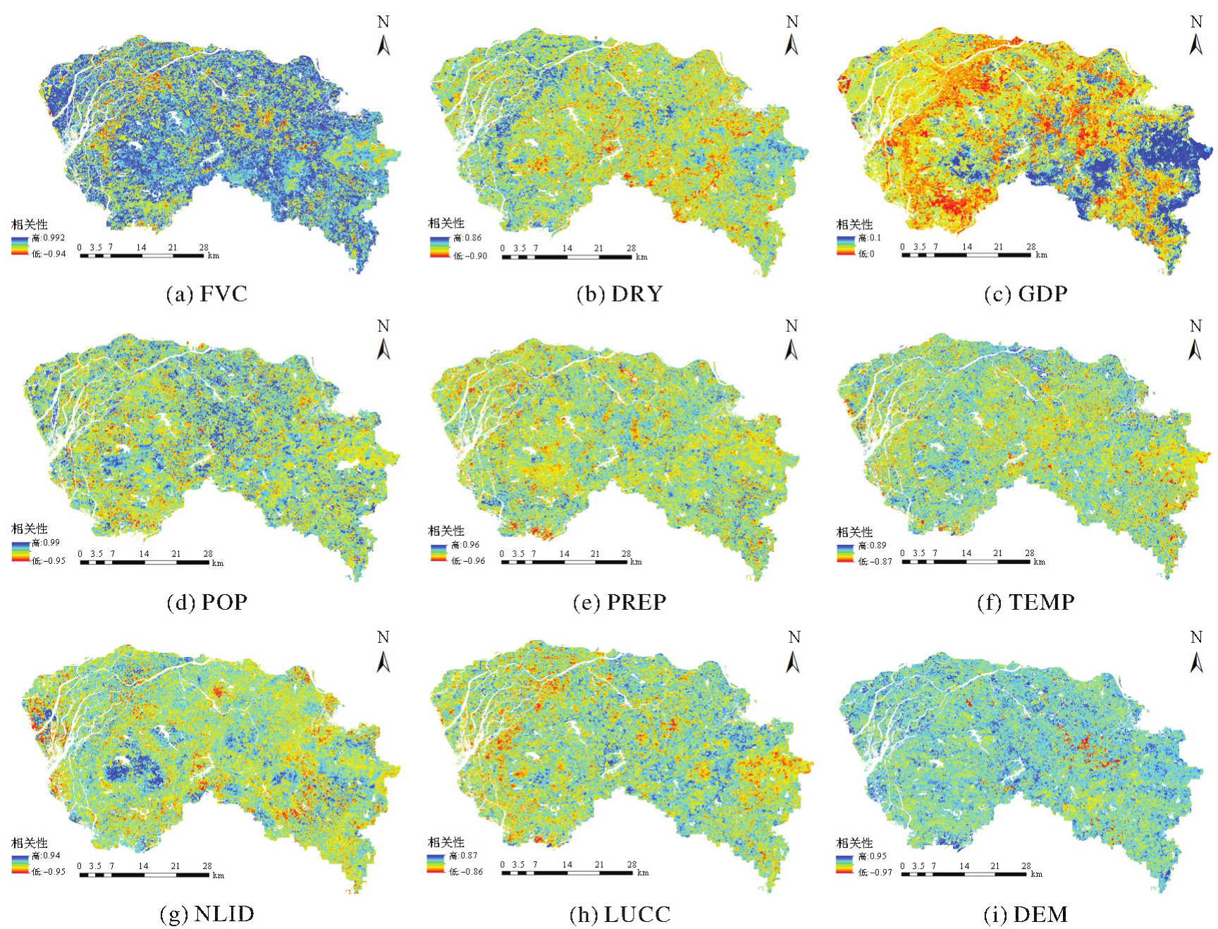
表6
2000、2005、2010、2015和2020年的因子检测器结果"
| 年份 | LUCC | FVC | DEM | GDP | POP | TEMP | NLID | DRY | PREP |
|---|---|---|---|---|---|---|---|---|---|
| 2000 | 0.378 1 | 0.376 7 | 0.311 0 | 0.256 7 | 0.237 7 | 0.236 4 | 0.228 9 | 0.116 0 | 0.096 0 |
| 2005 | 0.541 8 | 0.590 0 | 0.516 0 | 0.438 4 | 0.427 0 | 0.432 3 | 0.356 6 | 0.169 5 | 0.182 4 |
| 2010 | 0.513 4 | 0.572 0 | 0.498 7 | 0.369 0 | 0.413 2 | 0.384 0 | 0.317 0 | 0.169 6 | 0.162 2 |
| 2015 | 0.486 6 | 0.542 5 | 0.461 8 | 0.367 3 | 0.353 2 | 0.339 2 | 0.307 5 | 0.129 6 | 0.137 2 |
| 2020 | 0.461 5 | 0.595 4 | 0.422 0 | 0.463 2 | 0.355 3 | 0.299 2 | 0.270 9 | 0.166 0 | 0.109 9 |

图11
2000、2005、2010、2015和2020年的交互检测器结果"
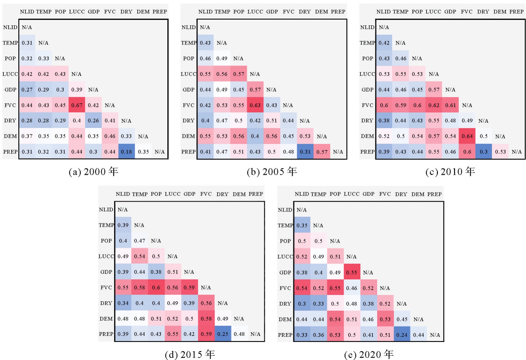
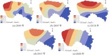
图12
FVC驱动因素的空间异质性"

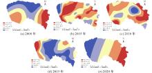
图13
GDP驱动因素的空间异质性"
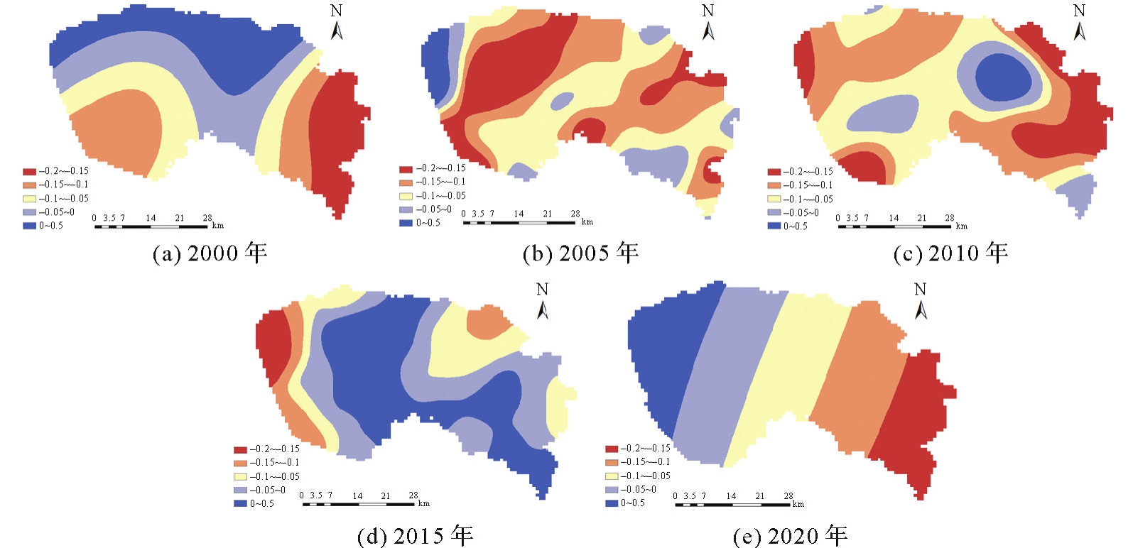
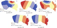
图14
LUCC驱动因素的空间异质性"

| [1] |
杨超. 遥感视角下的粤港澳大湾区城市化进程及其生态质量演变[J]. 测绘学报, 2023, 52(2): 343-343. DOI:.
doi: 10.11947/j.AGCS.2023.20210279 |
|
YANG Chao. Urbanization process and eco-environmental quality evolution in Guangdong-Hong Kong-Macao Greater Bay Area: a remote sensing perspective[J]. Acta Geodaetica et Cartographica Sinica, 2023, 52(2): 343-343. DOI:.
doi: 10.11947/j.AGCS.2023.20210279 |
|
| [2] |
黄丹. 滇中城市群新型城镇化与生态环境耦合协调的时空演变及驱动机制研究[J]. 测绘学报, 2024, 53(10): 2035-2035. DOI:.
doi: 10.11947/j.AGCS.2024.20230244 |
|
HUANG Dan. Study on time-space evolution and driving mechanism of coupling and coordination between new urbanization and eco-environment in central Yunnan megalopolis[J]. Acta Geodaetica et Cartographica Sinica, 2024, 53(10): 2035-2035. DOI:.
doi: 10.11947/j.AGCS.2024.20230244 |
|
| [3] | SWARUP B S, GORAI A K. Change detection analysis in coverage area of coal fire from 2009 to 2019 in Jharia Coalfield using remote sensing data[J]. International Journal of Remote Sensing, 2020, 41(24): 9545-9564. |
| [4] | CHU Hongshuai, VENEVSKY S, WU Chao, et al. NDVI-based vegetation dynamics and its response to climate changes at Amur-Heilongjiang River Basin from 1982 to 2015[J]. Science of the Total Environment, 2019, 650: 2051-2062. |
| [5] | FANG Hongliang, ZHANG Yinghui, WEI Shanshan, et al. Validation of global moderate resolution leaf area index (LAI) products over croplands in northeastern China[J]. Remote Sensing of Environment, 2019, 233: 111377. |
| [6] | ALEXANDER C. Normalised difference spectral indices and urban land cover as indicators of land surface temperature (LST)[J]. International Journal of Applied Earth Observation and Geoinformation, 2020, 86: 102013. |
| [7] | QIN Gexia, WANG Ninglian, WU Yuwei, et al. Spatiotemporal variations in eco-environmental quality and responses to drought and human activities in the middle reaches of the Yellow River basin, China from 1990 to 2022[J]. Ecological Informatics, 2024, 81: 102641. |
| [8] | HAZBAVI Z, SADEGHI S, GHOLAMALIFARD M, et al. Watershed health assessment using the pressure-state-response (PSR) framework[J]. Land Degradation & Development, 2020, 31(1): 3-19. |
| [9] | LI Ziying, YANG Han, HAO Tianyi. Assessing the consistency of remotely sensed multiple drought indices for monitoring drought phenomena in continental China[J]. IEEE Transactions on Geoscience and Remote Sensing, 2020, 58(8): 5490-5502. |
| [10] | GUO Hao, BAO Anming, LIU Tie, et al. Determining variable weights for an optimal scaled drought condition index (OSDCI): evaluation in central asia[J]. Remote sensing of environment, 2019, 231: 111220. |
| [11] | 徐涵秋. 城市遥感生态指数的创建及其应用[J]. 生态学报, 2013, 33(24): 7853-7862. |
| XU Hanqiu. A remote sensing urban ecological index and its application[J]. Acta Ecologica Sinica, 2013, 33(24): 7853-7862. | |
| [12] | YUAN Baodong, FU Lina, ZOU Yeai, et al. Spatiotemporal change detection of ecological quality and the associated affecting factors in Dongting Lake Basin, based on RSEI[J]. Journal of Cleaner Production, 2021, 302: 126995. |
| [13] | LIU Bin, ZHANG Feilian, WAN Wuyi, et al. Multi-objective decision-making for the ecological operation of built reservoirs based on the improved comprehensive fuzzy evaluation method[J]. Water Resources Management, 2019, 33(11): 3949-3964. |
| [14] | WU Shupu, GAO Xin, LEI Jiaqiang, et al. Ecological environment quality evaluation of the Sahel region in Africa based on remote sensing ecological index[J]. Journal of Arid Land, 2022, 14(1): 14-33. |
| [15] | YANG Xinyue, MENG Fei, FU Pingjie, et al. Time-frequency optimization of RSEI: a case study of Yangtze River Basin[J]. Ecological Indicators, 2022, 141: 109080. |
| [16] | LIU Chao, YANG Minghui, HOU Yuting, et al. Spatiotemporal evolution of island ecological quality under different urban densities: a comparative analysis of Xiamen and Kinmen Islands, Southeast China[J]. Ecological Indicators, 2021, 124: 107438. |
| [17] | 朱冬雨, 陈涛, 牛瑞卿, 等. 利用移动窗口遥感生态指数分析矿区生态环境[J]. 武汉大学学报(信息科学版), 2021, 46(3): 341-347. |
| ZHU Dongyu, CHEN Tao, NIU Ruiqing, et al. Analyzing the ecological environment of mining area by using moving window remote sensing ecological index[J]. Geomatics and Information Science of Wuhan University, 2021, 46(3): 341-347. | |
| [18] | 李婷婷, 马超, 郭增长. 基于RSEI模型的贺兰山长时序生态质量评价及影响因素分析[J]. 生态学杂志, 2021, 40(4): 1154-1165. |
| LI Tingting, MA Chao, GUO Zengchang. Ecological quality evaluation and influencing factors analysis of Helan Mountain based on RSEI[J]. Chinese Journal of Ecology, 2021, 40(4): 1154-1165. | |
| [19] | JIA Haowei, YAN Changzhen, XING Xuegang. Evaluation of eco-environmental quality in Qaidam Basin based on the ecological index (MRSEI) and GEE[J]. Remote Sensing, 2021, 13(22): 4543. |
| [20] | 刘英, 党超亚, 岳辉, 等. 改进型遥感生态指数与RSEI的对比分析[J]. 遥感学报, 2022, 26(4): 683-697. |
| LIU Ying, DANG Chaoya, YUE Hui, et al. Comparison between modified remote sensing ecological index and RSEI[J]. National Remote Sensing Bulletin, 2022, 26(4): 683-697. | |
| [21] | DONG Chunyuan, QIAO Rongrong, YANG Zhicheng, et al. Eco-environmental quality assessment of the artificial oasis of Ningxia section of the Yellow River with the MRSEI approach[J]. Frontiers in environmental science, 2023, 10: 1071631. |
| [22] | 张秦瑞, 赵良军, 林国军, 等. 改进遥感生态指数的宜宾市三江汇合区生态环境评价[J]. 自然资源遥感, 2022, 34(1): 230-237. |
| ZHANG Qinrui, ZHAO Liangjun, LIN Guojun, et al. Ecological environment assessment of three-river confluence in Yibin city using improved remote sensing ecological index[J]. Remote Sensing for Natural Resources, 2022, 34(1): 230-237. | |
| [23] | XU Hanqiu, DUAN Weifang, DENG Wenhui, et al. Evaluation of eco-environmental quality in Qaidam Basin based on the ecological index (MRSEI) and GEE[J]. Remote Sensing, 2022, 14(21): 5307. |
| [24] | 徐涵秋, 李春强, 林梦婧. RSEI应使用主成分分析或核主成分分析?[J]. 武汉大学学报(信息科学版), 2023, 48(4): 506-513. |
| XU Hanqiu, LI Chunqiang, LIN Mengjing. Should RSEI use PCA or kPCA?[J]. Geomatics and Information Science of Wuhan University, 2023, 48(4): 506-513. | |
| [25] | 徐涵秋, 邓文慧. MRSEI指数的合理性分析及其与RSEI指数的区别[J]. 遥感技术与应用, 2022, 37(1): 1-7. |
| XU Hanqiu, DENG Wenhui. Rationality analysis of MRSEI and its difference with RSEI[J]. Remote Sensing Technology and Application, 2022, 37(1): 1-7. | |
| [26] | 徐涵秋. 区域生态环境变化的遥感评价指数[J]. 中国环境科学, 2013, 33(5): 889-897. |
| XU Hanqiu. A remote sensing index for assessment of regional ecological changes[J]. China Environmental Science, 2013, 33(5): 889-897. | |
| [27] | XU Hanqiu. A new index for delineating built-up land features in satellite imagery[J]. International Journal of Remote Sensing, 2008, 29(14): 4269-4276. |
| [28] | RIKIMARU A, ROY P, MIYATAKE S. Tropical forest cover density mapping[J]. Tropical Ecology, 2002, 43(1): 39-47. |
| [29] | FERNANDES R, LEBLANC S. Parametric (modified least squares) and non-parametric (Theil-Sen) linear regressions for predicting biophysical parameters in the presence of measurement errors[J]. Remote sensing of environment, 2005, 95(3): 303-316. |
| [30] | LI Maolin, YAN Qingwu, LI Guie, et al. Spatio-temporal changes of vegetation cover and its influencing factors in Northeast China from 2000 to 2021[J]. Remote Sensing, 2022, 14(22): 5720. |
| [31] | WANG Jinfeng, HU Yi. Environmental health risk detection with GeogDetector[J]. Environmental Modelling & Software, 2012, 33: 114-115. |
| [32] | WU Decun. Spatially and temporally varying relationships between ecological footprint and influencing factors in China's provinces using geographically weighted regression (GWR)[J]. Journal of cleaner production, 2020, 261: 121089. |
| [33] | 东莞市生态环境局. 东莞市生态环境状况公报[EB/OL]. [2023-06-13]. https://dgepb.dg.cn/attachment/0185/185725/4025686.pdf. |
| Bureau of Ecology and Environment of Dongguan. 2022 report on the state of Dongguan city ecology and environment[EB/OL]. [2023-06-13]. https://dgepb.dg.cn/attachment/0185/185725/4025686.pdf. | |
| [34] | 东莞市生态环境局. 2023年度东莞市生态环境状态公报[EB/OL]. [2024-02-07]. https://dgepb.dg.cn/attachment/01265/265408/4214381.pdf. |
| Bureau of Ecology and Environment of Dongguan. 2023 report on the state of Dongguan city ecology and environment[EB/OL]. [2024-02-07]. https://dgepb.dg.cn/attachment/01265/265408/4214381.pdf. |
| [1] | 李鹏, 白建博, 李振洪, 王厚杰. 融合多轨道TS-InSAR的广域海岸带地面沉降监测及成因解析——以山东省为例[J]. 测绘学报, 2025, 54(7): 1178-1191. |
| [2] | 张林, 沈云中, 陈秋杰, 王奉伟. 红柳江区域陆地水储量变化及其驱动因素分析[J]. 测绘学报, 2022, 51(4): 622-630. |
| 阅读次数 | ||||||
|
全文 |
|
|||||
|
摘要 |
|
|||||