| [1] |
李建成, 陈俊勇, 宁津生, 等. 地球重力场逼近理论与中国2000似大地水准面的确定[M]. 武汉: 武汉大学出版社, 2003.
|
|
LI Jiancheng, CHEN Junyong, NING Jinsheng, et al. The earth's gravitational field approximation theory and the determination of China 2000 quasi-geoid[M]. Wuhan: Wuhan University Press, 2003.
|
| [2] |
WU Yihao, LUO Zhicai, CHEN Wu, et al. High-resolution regional gravity field recovery from Poisson wavelets using heterogeneous observational techniques[J]. Earth, Planets and Space, 2017, 69(34): 1-15.
|
| [3] |
NEYMAN Y M, LI J, LIU Q. Modification of Stokes and Vening-Meinesz formulas for the inner zone of arbitrary shape by minimization of upper bound truncation errors[J]. Journal of Geodesy, 1996, 70(7): 410-418.
|
| [4] |
ABBAK R A, SJÖBERG L E, ELLMANN A, et al. A precise gravimetric geoid model in a mountainous area with scarce gravity data: a case study in central Turkey[J]. Studia Geophysica et Geodaetica, 2012, 56(4): 909-927.
|
| [5] |
FEATHERSTONE W E. Deterministic, stochastic, hybrid and band-limited modifications of Hotine's integral[J]. Journal of Geodesy, 2013, 87(5): 487-500.
|
| [6] |
WICHIENGAROEN C. A comparison of gravimetric undulations computed by the modified Molodensky truncation method and the method of least squares spectral combination by optimal integral kernels[J]. Bulletin Géodésique, 1984, 58(4): 494-509.
|
| [7] |
NAHAVANDCHI H, SJÖBERG L E. Precise geoid determination over Sweden using the Stokes-Helmert method and improved topographic corrections[J]. Journal of Geodesy, 2001, 75(2): 74-88.
|
| [8] |
LIU Yusheng, LOU Lizhi. Unified land-ocean quasi-geoid computation from heterogeneous data sets based on radial basis functions[J]. Remote Sensing, 2022, 14(13): 3015.
|
| [9] |
FORSBERG R, TSCHERNING C C. The use of height data in gravity field approximation by collocation[J]. Journal of Geophysical Research: Solid Earth, 1981, 86(B9): 7843-7854.
|
| [10] |
HWANG C, HSIAO Y, SHIH H, et al. Geodetic and geophysical results from a Taiwan airborne gravity survey: data reduction and accuracy assessment[J]. Journal of Geophysical Research: Solid Earth, 2007, 112(B4). https://doi.org/10.1029/2005JB004220.
|
| [11] |
MCCUBBINE J C, AMOS M J, TONTINI F C, et al. The New Zealand gravimetric quasigeoid model 2017 that incorporates nationwide airborne gravimetry[J]. Journal of Geodesy, 2018, 92(8): 923-937.
|
| [12] |
WILLBERG M, ZINGERLE P, PAIL R. Integration of airborne gravimetry data filtering into residual least-squares collocation: example from the 1 cm geoid experiment[J]. Journal of Geodesy, 2020, 94(8): 75. https://doi.org/10.1007/s00190-020-01396-2.
|
| [13] |
VARGA M, PITONˇÁK M, NOVÁK P, et al. Contribution of GRAV-D airborne gravity to improvement of regional gravimetric geoid modelling in Colorado, USA[J]. Journal of Geodesy, 2021, 95(5): 53. https://doi.org/10.1007/s00190-021-01494-9.
|
| [14] |
IŞIK M S, EROL B, EROL S, et al. High-resolution geoid modeling using least squares modification of Stokes and Hotine formulas in Colorado[J]. Journal of Geodesy, 2021, 95(5): 49. https://doi.org/10.1007/s00190-021-01501-2.
|
| [15] |
WU Yihao, ZHOU Hao, ZHONG Bo, et al. Regional gravity field recovery using the GOCE gravity gradient tensor and heterogeneous gravimetry and altimetry data[J]. Journal of Geophysical Research (Solid Earth), 2017, 122(8): 6928-6952.
|
| [16] |
FREEDEN W, GERVENS T, SCHREINER M. Constructive approximation on the sphere (with applications to geomathematics) [M]. Oxford: Clarendon Press, 1998.
|
| [17] |
SCHMIDT M, FENGLER M, MAYER-GÜRR T, et al. Regional gravity modeling in terms of spherical base functions[J]. Journal of Geodesy, 2007, 81(1): 17-38.
|
| [18] |
KLEES R, TENZER R, PRUTKIN I, et al. A data-driven approach to local gravity field modelling using spherical radial basis functions[J]. Journal of Geodesy, 2008, 82(8): 457-471.
|
| [19] |
WITTWER T. Local gravity field modelling with radial basis functions[D]. Delft: Delft University of Technology, 2009.
|
| [20] |
NAEIMI M, FLURY J, BRIEDEN P. On the regularization of regional gravity field solutions in spherical radial base functions[J]. Geophysical Journal International, 2015, 202(2): 1041-1053.
|
| [21] |
马志伟, 陆洋, 涂弋, 等. 利用Abel-Poisson径向基函数模型化局部重力场[J]. 测绘学报, 2016, 45(9): 1019-1027. DOI: 10.11947/j.AGCS.2016.20150519.
|
|
MA Zhiwei, LU Yang, TU Yi, et al. Regional gravity field modeling with Abel-Poisson radial basis functions[J]. Acta Geodaetica et Cartographica Sinica, 2016, 45(9)1019-1027. DOI: 10.11947/j.AGCS.2016.20150519.
|
| [22] |
MA Zhiwei, YANG Meng, LIU Jie. Regional gravity field modeling using band-limited SRBFs: a case study in Colorado[J]. Remote Sensing, 2023, 15(18): 4515.
|
| [23] |
KLEES R, SLOBBE D C, FARAHANI H H. A methodology for least-squares local quasi-geoid modelling using a noisy satellite-only gravity field model[J]. Journal of Geodesy, 2018, 92(4): 431-442.
|
| [24] |
LIU Qing, SCHMIDT M, SÁNCHEZ L, et al. Regional gravity field refinement for (quasi-) geoid determination based on spherical radial basis functions in Colorado[J]. Journal of Geodesy, 2020, 94(10): 99. https://doi.org/10.1007/s00190-020-01431-2.
|
| [25] |
LI Xiaopeng. Using radial basis functions in airborne gravimetry for local geoid improvement[J]. Journal of Geodesy, 2018, 92(5): 471-485.
|
| [26] |
HEISKANENW A, MORITZ H. Physical geodesy[M]. San Francisco: W. H. Freeman, 1967.
|
| [27] |
KOCH K R, KUSCHE J. Regularization of geopotential determination from satellite data by variance components[J]. Journal of Geodesy, 2002, 76(5): 259-268.
|
| [28] |
BARTHELMES F. Definition of functionals of the geopotential and their calculation from spherical harmonic models[R]. Potsdam: GFZ German Research Centre for Geosciences, 2013
|
| [29] |
MORITZ H. Geodetic reference system 1980[J]. Journal of Geodesy, 2000, 74(1): 128-133.
|
| [30] |
HIRT C, REXER M. Earth2014: 1 arc-min shape, topography, bedrock and ice-sheet models-available as gridded data and degree-10, 800 spherical harmonics[J]. International Journal of Applied Earth Observation and Geoinformation, 2015, 39: 103-112.
|
| [31] |
FOROUGHI I, VANÍCˇEK P, KINGDON R W, et al. Sub-centimetre geoid[J]. Journal of Geodesy, 2019, 93(6): 849-868.
|
| [32] |
JIANG Tao, WANG Yanming. On the spectral combination of satellite gravity model, terrestrial and airborne gravity data for local gravimetric geoid computation[J]. Journal of Geodesy, 2016, 90(12): 1405-1418.
|
| [33] |
TORGE W. Gravimetry[M]. Berlin: Walter de Gruyter, 1989.
|
| [34] |
EICKER A. Gravity field refinement by radial basis functions from in-situ satellite data[D]. Bonn: Rheinische Friedrich-Wilhelms-Universität Bonn, 2008.
|
| [35] |
BENTEL K, SCHMIDT M, DENBY C. Artifacts in regional gravity representations with spherical radial basis functions[J]. Journal of Geographical Sciences, 2013, 3(3): 173-187.
|
| [36] |
NAEIMI M. Inversion of satellite gravity data using spherical radial base functions[D]. Hannover: Leibniz Universität Hannover, 2013.
|
| [37] |
赵永奇, 李建成, 徐新禹, 等. 利用GOCE和GRACE卫星观测数据确定静态重力场模型[J]. 地球物理学报, 2023, 66(6): 2322-2336.
|
|
ZHAO Yongqi, LI Jiancheng, XU Xinyu, et al. Determination of static gravity field model by using satellite data of GOCE and GRACE[J]. Chinese Journal of Geophysics, 2023, 66(6): 2322-2336.
|
| [38] |
CHEN J, ZHANG X, CHEN Q, et al. Static gravity field recovery and accuracy analysis based on reprocessed GOCE level 1b gravity gradient observations[C]//Proceedings of the 24th EGU General Assembly, Vienna: IEEE, 2022.
|
| [39] |
SÁNCHEZ L, ÅGREN J, HUANG Jianliang, et al. Strategy for the realisation of the international height reference system (IHRS)[J]. Journal of Geodesy, 2021, 95(3): 33. https://doi.org/10.1007/s00190-021-01481-0.
|
| [40] |
BUCHA B, JANÁK J, PAPCˇO J, et al. High-resolution regional gravity field modelling in a mountainous area from terrestrial gravity data[J]. Geophysical Journal International, 2016, 207(2): 949-966.
|
| [41] |
REXER M, HIRT C, CLAESSENS S, et al. Layer-based modelling of the earth's gravitational potential up to 10-km scale in spherical harmonics in spherical and ellipsoidal approximation[J]. Surveys in Geophysics, 2016, 37(6): 1035-1074.
|
| [42] |
HIRT C, KUHN M, CLAESSENS S, et al. Study of the earth's short-scale gravity field using the ERTM2160 gravity model[J]. Computers & Geosciences, 2014, 73: 71-80.
|
| [43] |
WANG Y M, SALEH J, LI X, et al. The US gravimetric geoid of 2009 (USGG2009): model development and evaluation[J]. Journal of Geodesy, 2012, 86(3): 165-180.
|


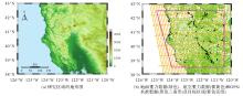
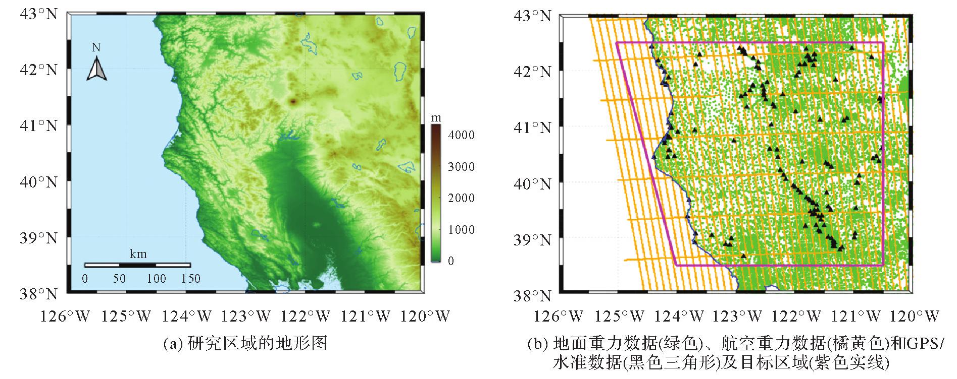
 ), 边少锋2, 徐如一3, 陈永冰2