| [1] |
刘万增, 彭震中. 我国测绘地理信息成果保密政策分析及对策[J]. 地理信息世界, 2016, 23(4):54-58.
|
|
LIU Wanzeng, PENG Zhenzhong. Analysis and countermeasures for secrecy policy on mapping geographic information results of China[J]. Geomatics World, 2016, 23(4):54-58.
|
| [2] |
易树柏. 论地理信息安全在国家安全中的作用[J]. 理论界, 2016 (8):40-48.
|
|
YI Shubai. On the role of geoinformation security to national security strategy[J]. Theory Horizon, 2016 (8):40-48.
|
| [3] |
高惠君. 城市规划空间数据的多尺度处理与表达研究[D]. 北京: 中国矿业大学(北京), 2012.
|
|
GAO Huijun. Research on multi-scale handling and representation of urban planning spatial data[D]. Beijing: China University of Mining & Technology, Beijing, 2012.
|
| [4] |
刘万增, 陈军, 赵勇, 等. 地理信息保密安全评估的基本问题与对策[J]. 时空信息学报, 2023, 30(4):474-481.
|
|
LIU Wanzeng, CHEN Jun, ZHAO Yong, et al. Fundamental issues and countermeasures of geographic information security assessment[J]. Journal of Spatio-Temporal Information, 2023, 30(4):474-481.
|
| [5] |
王家耀, 成毅. 空间数据的多尺度特征与自动综合[J]. 海洋测绘, 2004, 24(4):1-3.
|
|
WANG Jiayao, CHENG Yi. The multiple character of spatial data and automated generalization[J]. Hydrographic Surveying and Charting, 2004, 24(4):1-3.
|
| [6] |
孙庆先, 李茂堂, 路京选, 等. 地理空间数据的尺度问题及其研究进展[J]. 地理与地理信息科学, 2007, 23(4):53-56, 80.
|
|
SUN Qingxian, LI Maotang, LU Jingxuan, et al. Scale issue and its research progress of geospatial data[J]. Geography and Geo-Information Science, 2007, 23(4):53-56, 80.
|
| [7] |
陈俊杰. 不同尺度下地理实体的一体化组织与表达方法研究[D]. 杭州: 浙江大学, 2011.
|
|
CHEN Junjie. Study on the integrative organization and representation method for geographical entity in different scales[D]. Hangzhou: Zhejiang University, 2011.
|
| [8] |
刘凯, 秦耀辰. 论地理信息的尺度特性[J]. 地理与地理信息科学, 2010, 26(2):1-5.
|
|
LIU Kai, QIN Yaochen. On scale characteristics of geographic information[J]. Geography and Geo-Information Science, 2010, 26(2):1-5.
|
| [9] |
周卫, 朱长青, 吴卫东. 地理信息的安全特征综述[J]. 测绘通报, 2015 (10):122-125.
|
|
ZHOU Wei, ZHU Changqing, WU Weidong. Review of the security features of geographic information[J]. Bulletin of Surveying and Mapping, 2015 (10):122-125.
|
| [10] |
朱长青, 任娜, 徐鼎捷. 地理信息安全技术研究进展与展望[J]. 测绘学报, 2022, 51(6):1017-1028. DOI:10.11947/j.AGCS.2022.20220172.
|
|
ZHU Changqing, REN Na, XU Dingjie. Geo-information security technology: progress and prospects[J]. Acta Geodaetica et Cartographica Sinica, 2022, 51(6):1017-1028. DOI:10.11947/j.AGCS.2022.20220172.
|
| [11] |
乔朝飞, 贾宗仁, 徐坤, 等. 从国外情况看我国地理信息保密政策调整[J]. 测绘与空间地理信息, 2020, 43(12):1-4.
|
|
QIAO Chaofei, JIA Zongren, XU Kun, et al. Adjustment of geospatial information confidentiality policy in China from the perspective of foreign situation[J]. Geomatics & Spatial Information Technology, 2020, 43(12):1-4.
|
| [12] |
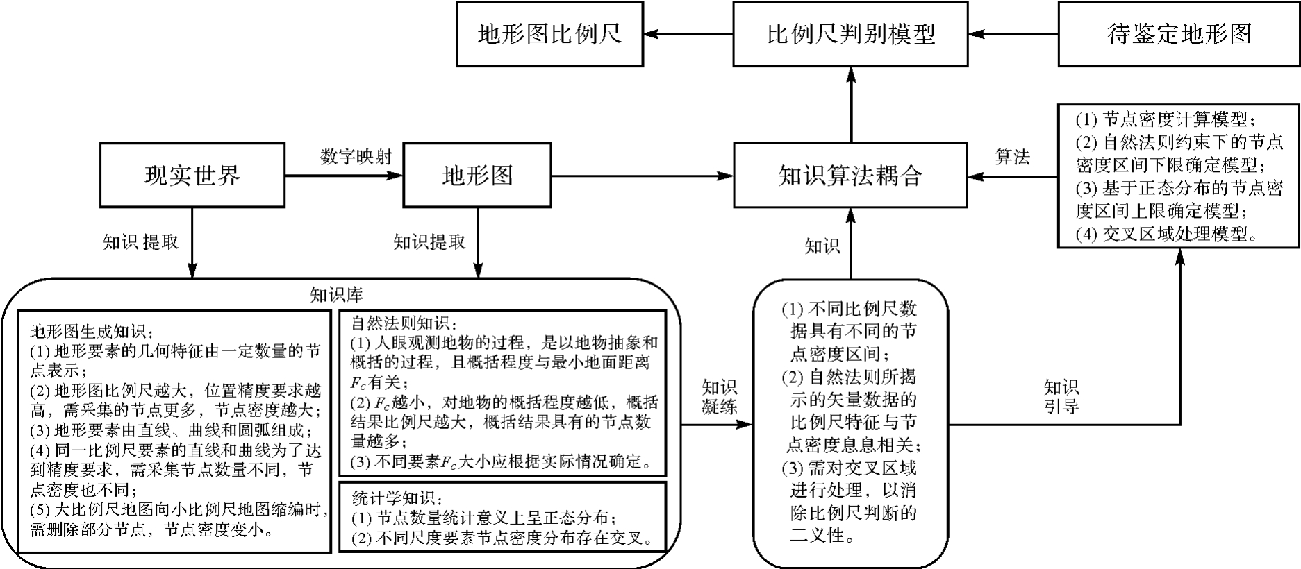
任加新, 刘万增, 陈军, 等. 知识引导的碎片化栅格地形图比例尺智能识别[J]. 测绘学报, 2024, 53(1):146-157. DOI:10.11947/j.AGCS.2024.20230005.
|
|
REN Jiaxin, LIU Wanzeng, CHEN Jun, et al. Knowledge-guided intelligent recognition of the scale for fragmented raster topographic maps[J]. Acta Geodaetica et Cartographica Sinica, 2024, 53(1):146-157. DOI:10.11947/j.AGCS.2024.20230005.
|
| [13] |
CHEN Wanzhi. Internet geographic information security supervision platform architecture research[J]. International Journal of Online and Biomedical Engineering (IJOE), 2013, 9(S2):13.
|
| [14] |
王迪, 钱海忠, 赵钰哲. 综述与展望:地理空间数据的管理、多尺度变换与表达[J]. 地球信息科学学报, 2022, 24(12):2265-2281.
|
|
WANG Di, QIAN Haizhong, ZHAO Yuzhe. Review and prospect: management, multi-scale transformation and representation of geospatial data[J]. Journal of Geo-Information Science, 2022, 24(12):2265-2281.
|
| [15] |
艾廷华, 张翔. 地理信息科学中尺度概念的诠释与表达[J]. 测绘学报, 2022, 51(7):1640-1652. DOI:10.11947/j.AGCS.2022.20220143.
|
|
AI Tinghua, ZHANG Xiang. An interpretation and representation of scale concept in geo-information sciences[J]. Acta Geodaetica et Cartographica Sinica, 2022, 51(7):1640-1652. DOI:10.11947/j.AGCS.2022.20220143.
|
| [16] |
吴冰娇. 基于几何与语义相似性的多尺度道路网数据匹配方法研究[D]. 兰州: 兰州交通大学, 2022.
|
|
WU Bingjiao. Research on multi-scale road network data matching method based on geometric and semantic similarity[D]. Lanzhou: Lanzhou Jiatong University, 2022.
|
| [17] |
LI Zhilin, OPENSHAW S. A natural principle for the objective generalization of digital maps[J]. Cartography and Geographic Information Systems, 1993, 20(1):19-29.
|
| [18] |
LI Zhilin. Transformation of spatial representation in scale dimension: a new paradigm for digital generalization of spatial data[J]. International Archives of Photogrammetry and Remote Sensing, 1996, XXXI(B3):453-458.
|
| [19] |
钟其洋, 郭庆胜, 王勇, 等. 基于空间粒度的矢量空间数据比例尺估算方法[J]. 测绘通报, 2022 (8):117-122.
|
|
ZHONG Qiyang, GUO Qingsheng, WANG Yong, et al. The method for estimating the scale of vector spatial data based on spatial granularity[J]. Bulletin of Surveying and Mapping, 2022 (8):117-122.
|
| [20] |
樊玉鑫, 郭庆胜, 王勇, 等. 参考样本库的线状道路空间数据比例尺估算[J]. 测绘科学, 2022, 47(7):208-215.
|
|
FAN Yuxin, GUO Qingsheng, WANG Yong, et al. Scale estimation for linear road spatial data on sample database[J]. Science of Surveying and Mapping, 2022, 47(7):208-215.
|
| [21] |
刘鹏程, 李精忠, 艾廷华. 数字地图要素的细节层次一致性评价模型研究[J]. 中国矿业大学学报, 2019, 48(2):437-444.
|
|
LIU Pengcheng, LI Jingzhong, AI Tinghua. Evaluation model of level of detail consistency of the features on digital maps[J]. Journal of China University of Mining & Technology, 2019, 48(2):437-444.
|
| [22] |
刘万增, 陆辰妮, 霍亮, 等. 最优信息熵约束的居民地点状要素选取方法[J]. 武汉大学学报(信息科学版), 2021, 46(8):1178-1185.
|
|
LIU Wanzeng, LU Chenni, HUO Liang, et al. Selection method of residential point features constrained by optimal information entropy[J]. Geomatics and Information Science of Wuhan University, 2021, 46(8):1178-1185.
|
| [23] |
付青松. GIS矢栅数据结构及数据组织管理研究[J]. 测绘与空间地理信息, 2010, 33(6):64-66, 72.
|
|
FU Qingsong. The research of GIS raster data structure and data organization and management[J]. Geomatics & Spatial Information Technology, 2010, 33(6):64-66, 72.
|
| [24] |
刘万增, 陈军, 金舒平, 等. 空间曲线长度计算与精度评价模型[J]. 测绘通报, 2013 (2):38-40, 58.
|
|
LIU Wanzeng, CHEN Jun, JIN Shuping, et al. Space curve length calculation and accuracy assessment model[J]. Bulletin of Surveying and Mapping, 2013 (2):38-40, 58.
|
| [25] |
DOUGLAS D H, PEUCKER T K. Algorithms for the reduction of the number of points required to represent a digitized line or its caricature[J]. Classics in Cartography: Reflections on Influential Articles from Cartographica, 2011:15-28.
|
| [26] |
杨得志, 王杰臣, 闾国年. 矢量数据压缩的Douglas-Peucker算法的实现与改进[J]. 测绘通报, 2002 (7):18-19, 22.
|
|
YANG Dezhi, WANG Jiechen, LÜ Guonian. Study of realization method and improvement of Douglas-Peucher algorithm of vector data compressing[J]. Bulletin of Surveying and Mapping, 2002 (7):18-19, 22.
|
| [27] |
李霖, 应申. 空间尺度基础性问题研究[J]. 武汉大学学报(信息科学版), 2005, 30(3):199-203.
|
|
LI Lin, YING Shen. Fundamental problem on spatial scale[J]. Geomatics and Information Science of Wuhan University, 2005, 30(3):199-203.
|
| [28] |
李志林, 刘启亮, 唐建波. 尺度驱动的空间聚类理论[J]. 测绘学报, 2017, 46(10):1534-1548. DOI:10.11947/j.AGCS.2017.20170275.
|
|
LI Zhilin, LIU Qiliang, TANG Jianbo. Towards a scale-driven theory for spatial clustering[J]. Acta Geodaetica et Cartographica Sinica, 2017, 46(10):1534-1548. DOI:10.11947/j.AGCS.2017.20170275.
|
| [29] |
LI Zhilin, OPENSHAW S. Algorithms for automated line generalization based on a natural principle of objective generalization[J]. International Journal of Geographical Information Systems, 1992, 6(5):373-389.
|


 ), 王新鹏2,3(