


测绘学报 ›› 2024, Vol. 53 ›› Issue (7): 1401-1416.doi: 10.11947/j.AGCS.2024.20230327
陈超1( ), 梁锦涛2,3, 杨刚4(), 孙伟伟4, 龚绍军3, 王建强5
收稿日期:2023-08-08
发布日期:2024-08-12
通讯作者:
杨刚
E-mail:chenchao@usts.edu.cn;yanggang@nbu.edu.cn
作者简介:陈超(1982—),男,博士,教授,研究方向为海岸带环境遥感。E-mail:chenchao@usts.edu.cn
基金资助:
Chao CHEN1(), Jintao LIANG2,3, Gang YANG4(), Weiwei SUN4, Shaojun GONG3, Jianqiang WANG5
Received:2023-08-08
Published:2024-08-12
Contact:
Gang YANG
E-mail:chenchao@usts.edu.cn;yanggang@nbu.edu.cn
About author:CHEN Chao (1982—), male, PhD, professor, majors in remote sensing of coastal environment. E-mail: chenchao@usts.edu.cn
Supported by:摘要:
在显著气候变化叠加人类活动干扰的背景下,可持续的自然资源管理对于精准掌握土地覆盖信息的需求不断提升。为应对地表形态的复杂性、地物类型的多样性、遥感图像特征的非线性给传统遥感图像分类方法带来的挑战,本文基于随机森林Gini指数,提出了一种10%阈值决策的遥感特征参数优选方法,旨在筛选出最优的遥感特征参数组合,达到最佳土地覆盖分类效果。首先,选择光谱特征、纹理特征、温热特征、高程特征、主成分特征组成遥感影像堆栈。然后,设置多组决策树对特征贡献度进行交叉验证,并根据特征重要性的归一化均值确定特征排序。最后,设定阈值,筛选出符合要求的遥感特征参数,并迭代过程。选择覆盖江苏盐城自然保护区的Sentinel-2遥感图像开展试验,结果表明,本文方法筛选出的遥感特征参数代表性好,与CART、SVM、KNN和只使用波段信息的RF相比,分类结果地物边界清晰,类别属性准确,总体精度和Kappa系数分别为96.20%和0.955 6。本文研究能够为区域空间规划和可持续发展提供技术支持。
中图分类号:
陈超, 梁锦涛, 杨刚, 孙伟伟, 龚绍军, 王建强. 面向土地覆盖精准分类的遥感特征参数优选方法[J]. 测绘学报, 2024, 53(7): 1401-1416.
Chao CHEN, Jintao LIANG, Gang YANG, Weiwei SUN, Shaojun GONG, Jianqiang WANG. Remote sensing parameters optimization for accurate land cover classification[J]. Acta Geodaetica et Cartographica Sinica, 2024, 53(7): 1401-1416.

图1
研究区区位"
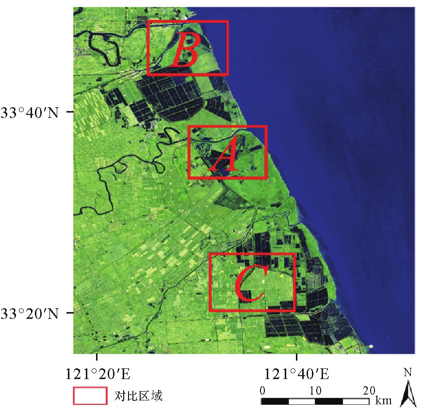
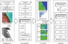
图2
技术路线"

表1
遥感影像堆栈所包含的特征参数"
| 特征参数集 | 特征参数 | 卫星或数据源 |
|---|---|---|
| 光谱特征参数 | Blue(蓝波段)、Green(绿波段)、Red(红波段)、VNIR(可见光-近红外波段)、SWIR1(短波红外波段1)、SWIR2(短波红外波段2)、NDVI(归一化差异植被指数)、EVI(增强植被指数)、RVI(比值植被指数)、SAVI(土壤调整植被指数)、NDBI(归一化差异建筑指数)、MNDWI(改进的归一化差异水体指数) | Sentinel-2 |
| 纹理特征参数 | ASM(角二阶距)、CONT(对比度)、CORR(相关度)、VAR(方差)、IDM(逆差距)、SAVG(求和平均值)、SENT(总熵)、ENT(熵)、DENT(差分熵) | Sentinel-2 |
| 温热特征参数 | LST(地表温度)、TIR1(热红外波段1)、TIR2(热红外波段2) | Landsat 8 |
| 高程特征参数 | DEM(高程)、Slope(坡度)、Aspect(坡向) | SRTMV3 |
| 主成分特征参数 | PC1(第一主成分分量)、PC2(第二主成分分量)、PC3(第三主成分分量) | Sentinel-2 |
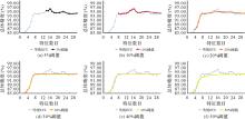
图3
不同阈值下精度曲线"
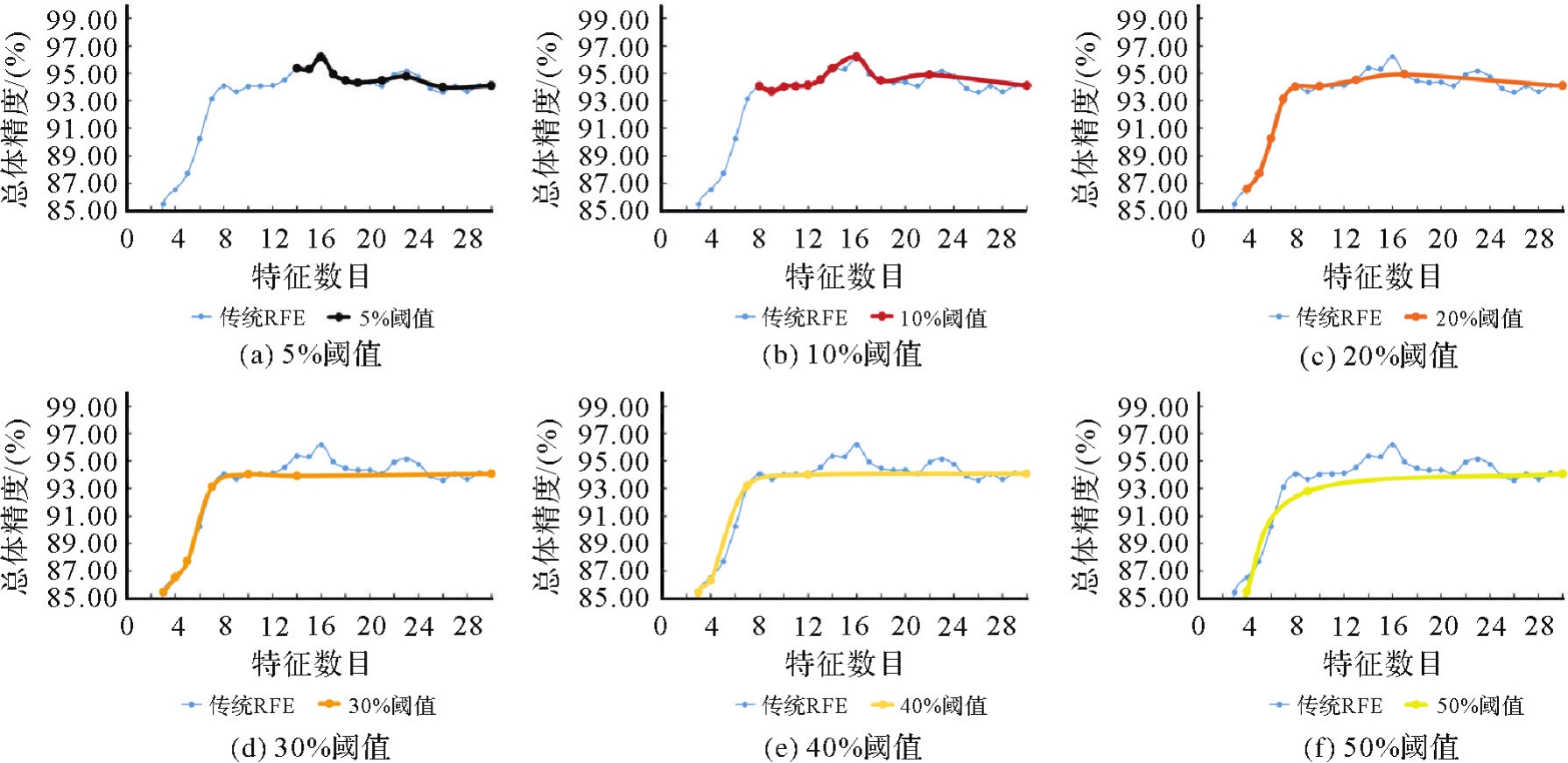
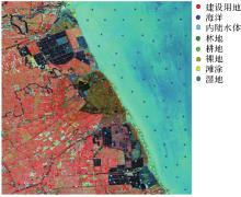
图4
原始影像及样本点分布情况"

表2
研究区土地覆盖类型及遥感图像表现特征"
| 土地利用类型 | 定义 | 样本的数量 | 示例图像 |
|---|---|---|---|
| 建设用地 | 城乡居民点及工矿交通等用地 | 120 | 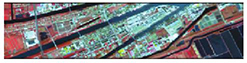 |
| 海洋 | 盐城东部的黄海区域 | 50 |  |
| 内陆水体 | 天然陆地水域、水利设施用地、养殖池塘 | 70 | 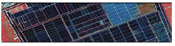 |
| 林地 | 树木、灌木和其他林地 | 80 | 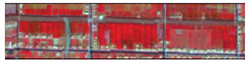 |
| 耕地 | 可正常耕作的农田 | 150 | 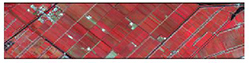 |
| 裸地 | 地表为土壤或岩石,基本不被植被覆盖 | 120 | 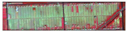 |
| 滩涂 | 永久或季节性被浅水覆盖的区域 | 50 |  |
| 湿地 | 高潮位和低潮位之间的潮汐淹没区 | 100 | 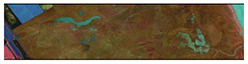 |
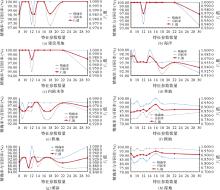
图5
不同数量特征参数下的精确率、召回率、F1值曲线"

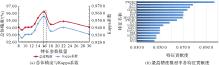
图6
OA、Kappa系数曲线及最高精度模型中的特征排序"
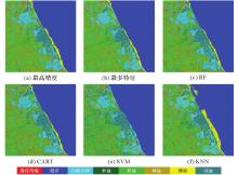
图7
原始影像与各模型分类结果"
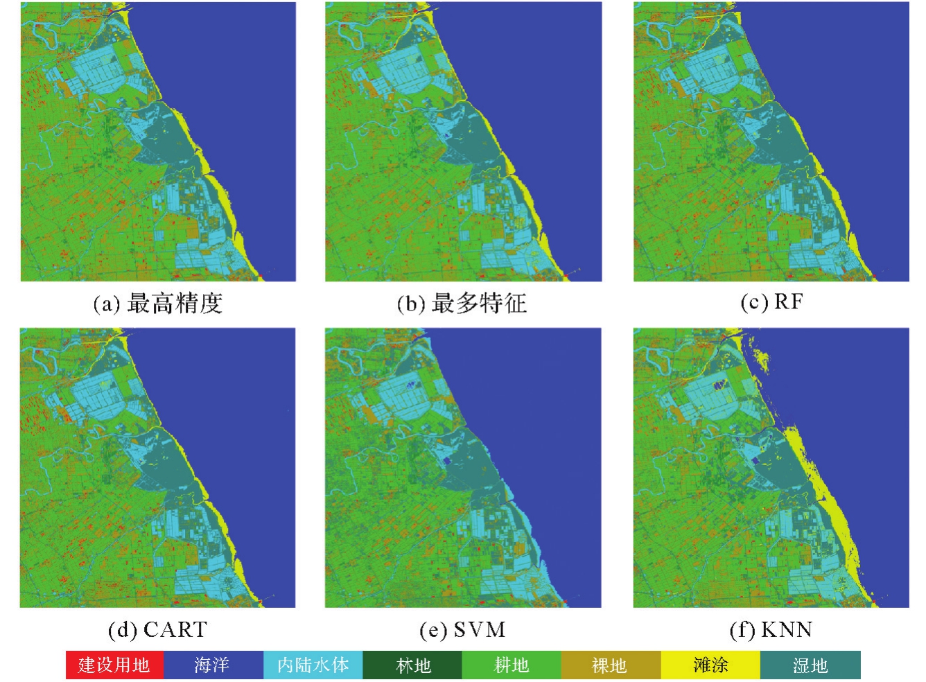
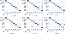
图8
各模型混淆矩阵"
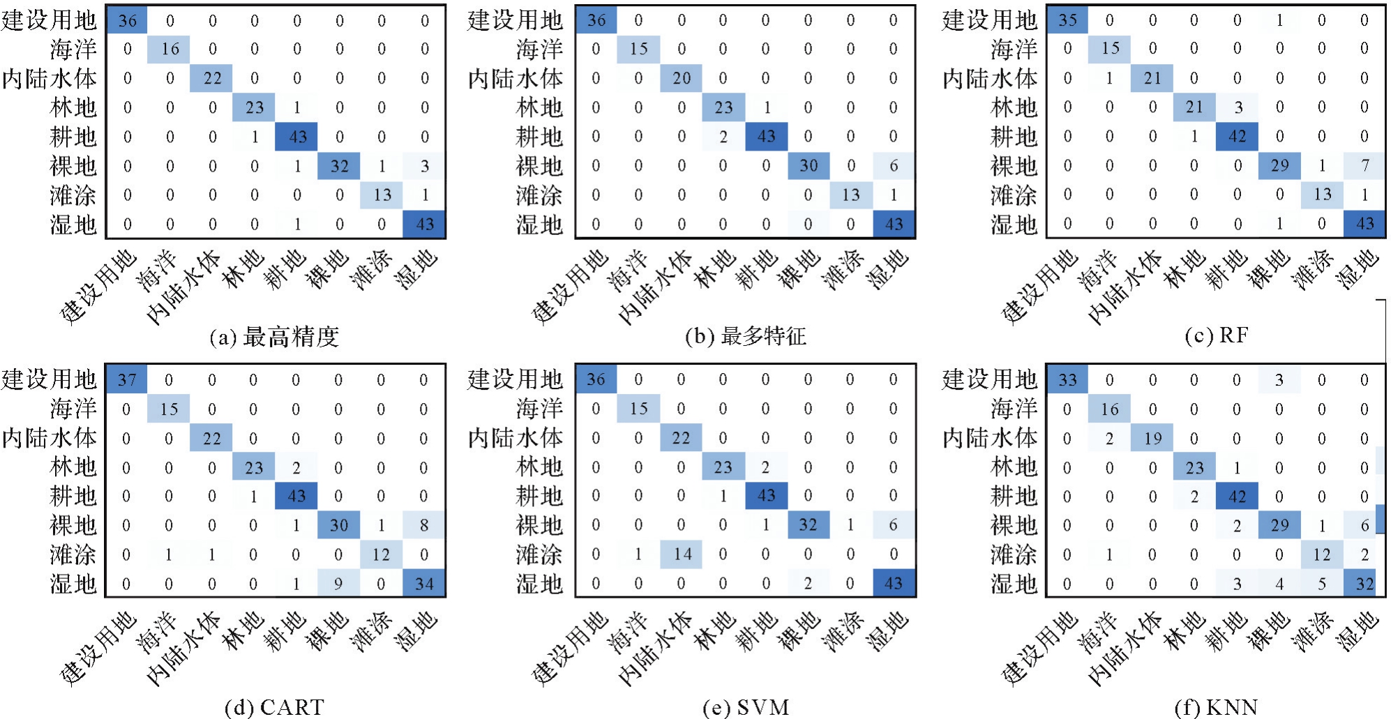
表3
各模型F1值"
| 土地利用类型 | 最高精度 | 最多特征 | RF | CART | SVM | KNN |
|---|---|---|---|---|---|---|
| 建设用地 | 1.000 0 | 1.000 0 | 0.985 9 | 1.000 0 | 1.000 0 | 0.956 5 |
| 海水 | 1.000 0 | 0.967 7 | 0.967 7 | 0.967 7 | 0.967 7 | 0.914 3 |
| 内陆水体 | 1.000 0 | 0.975 6 | 0.976 7 | 0.977 8 | 0.758 6 | 0.950 0 |
| 林地 | 0.958 3 | 0.938 8 | 0.913 0 | 0.938 8 | 0.938 8 | 0.938 8 |
| 耕地 | 0.955 6 | 0.966 3 | 0.943 8 | 0.945 1 | 0.955 6 | 0.913 0 |
| 裸地 | 0.927 6 | 0.869 6 | 0.840 6 | 0.759 5 | 0.864 9 | 0.783 8 |
| 滩涂 | 0.928 6 | 0.928 6 | 0.928 6 | 0.857 1 | 0.000 0 | 0.727 3 |
| 湿地 | 0.945 1 | 0.905 3 | 0.905 3 | 0.781 6 | 0.914 9 | 0.761 9 |
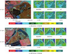
图9
本文方法在湿地区域的分类效果"
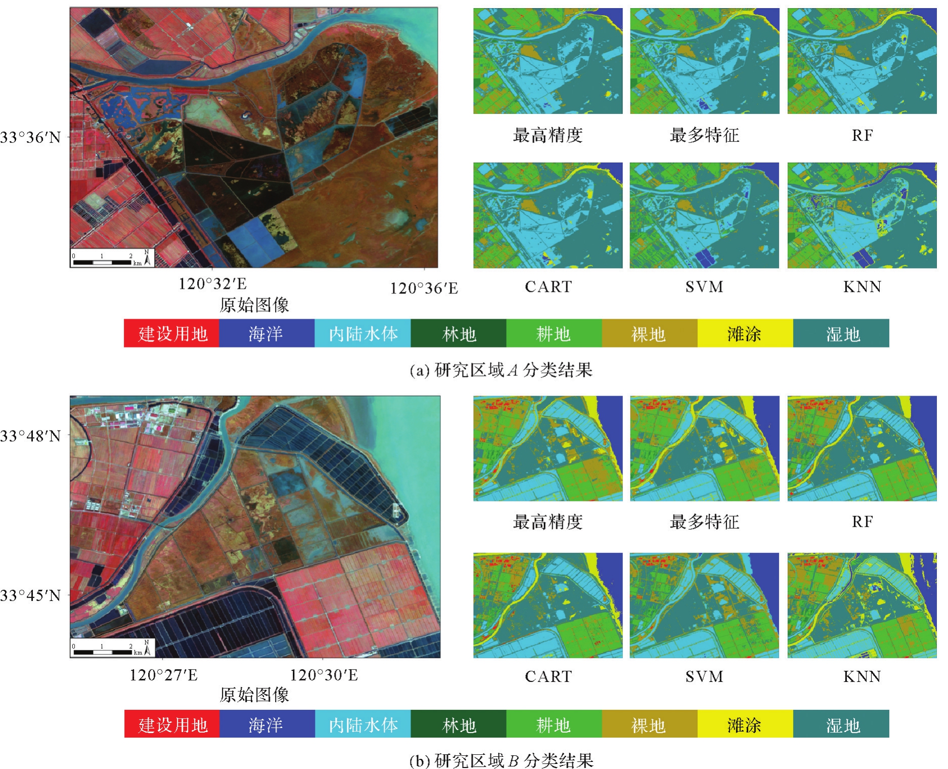
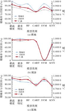
图10
不同模型下裸地、潮滩和湿地的精确率、召回率、F1值曲线"

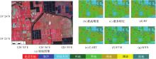
图11
本文方法在耕地区域的分类效果"

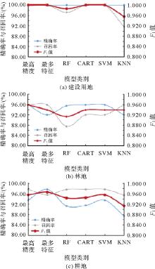
图12
不同模型下建设用地、林地和耕地的精确率、召回率、F1值曲线"

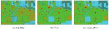
图13
本文模型与传统语义分割模型对比"
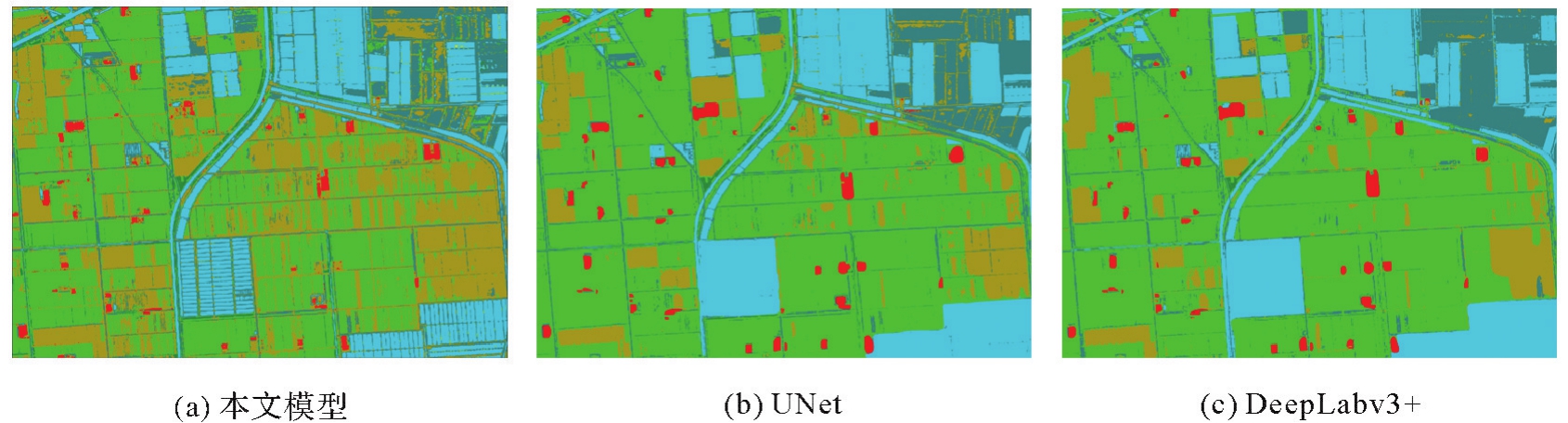
表4
本文模型与传统语义分割模型分类精度"
| 模型 | 总体精度/(%) | Kappa系数 |
|---|---|---|
| 本文模型 | 96.20 | 0.955 6 |
| UNet | 92.37 | 0.871 7 |
| DeepLabv3+ | 93.50 | 0.889 8 |
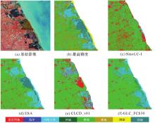
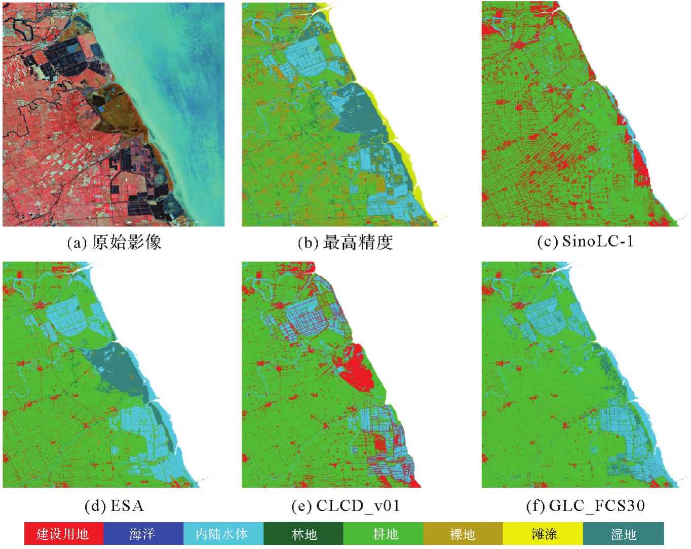
图14
不同土地覆被产品分类结果"
| [1] | 侯婉, 侯西勇. 考虑湿地精细分类的全球海岸带土地利用/覆盖遥感分类系统[J]. 热带地理, 2018, 38(6):866-873. |
| HOU Wan, HOU Xiyong. Remote sensing classification system of land use and land cover for global coastal zone considering fine classification of wetlands[J]. Tropical Geography, 2018, 38(6):866-873. | |
| [2] | 冯如意, 王力哲, 曾铁勇. 高光谱遥感图像亚像元信息提取方法综述[J]. 测绘学报, 2023, 52(7):1187-1201. DOI: 10.11947/j.AGCS.2023.20220491. |
| FENG Ruyi, WANG Lizhe, ZENG Tieyong. Review of hyperspectral remote sensing image subpixel information extraction[J]. Acta Geodaetica et Cartographica Sinica, 2023, 52(7):1187-1201. DOI: 10.11947/j.AGCS.2023.20220491. | |
| [3] | 梁锦涛, 陈超, 孙伟伟, 等. 基于Landsat长时间序列卫星影像和GEE云平台的杭州湾土地利用/覆被变化时空格局演变分析 [J]. 遥感学报, 2023, 27(6):1480-1495. DOI: 10.11834/jrs.20232614. |
| LIANG Jintao, CHEN Chao, SUN Weiwei, et al. Spatio-temporal land use/cover change dynamics in Hangzhou Bay, China using long-term Landsat time series and GEE platform[J]. National Remote Sensing Bulletin, 2023, 27(6):1480-1495. DOI: 10.11834/jrs.20232614. | |
| [4] | 侯婉, 侯西勇. 全球海岸带多源土地利用/覆盖遥感分类产品一致性分析[J]. 地球信息科学学报, 2019, 21(7):1061-1073. |
| HOU Wan, HOU Xiyong. Consistency of the multiple remote sensing-based land use and land cover classification products in the global coastal zones[J]. Journal of Geo-Information Science, 2019, 21(7):1061-1073. | |
| [5] | GENG Jiachen, SHEN Shi, CHENG Changxiu, et al. A hybrid spatiotemporal convolution-based cellular automata model (ST-CA) for land-use/cover change simulation [J]. International Journal of Applied Earth Observation and Geoinformation, 2022, 110:102789. DOI: 10.1016/j.jag.2022.102789. |
| [6] | 骆剑承, 胡晓东, 吴田军, 等. 高分遥感驱动的精准土地利用与土地覆盖变化信息智能计算模型与方法研究[J]. 遥感学报, 2021, 25(7):1351-1373. |
| LUO Jiancheng, HU Xiaodong, WU Tianjun, et al. Research on intelligent calculation model and method of precision land use/cover change information driven by high-resolution remote sensing[J]. National Remote Sensing Bulletin, 2021, 25(7):1351-1373. | |
| [7] | 陈超, 陈慧欣, 陈东, 等. 舟山群岛海岸线遥感信息提取及时空演变分析[J]. 国土资源遥感, 2021, 33(2):141-152. |
| CHEN Chao, CHEN Huixin, CHEN Dong, et al. Coastline extraction and spatial-temporal variations using remote sensing technology in Zhoushan Islands[J]. Remote Sensing for Land & Resources, 2021, 33(2):141-152. | |
| [8] | 孙根云, 付航, 张爱竹, 等. 高光谱影像奇异谱分析特征提取方法:综述与评价 [J]. 测绘学报, 2023, 52(7):1148-1163. DOI: 10.11947/j.AGCS.2023.20220542. |
| SUN Genyun, FU Hang, ZHANG Aizhu, et al. Singular spectrum analysis method for hyperspectral imagery feature extraction: a review and evaluation [J]. Acta Geodaetica et Cartographica Sinica, 2023, 52(7):1148-1163. DOI: 10.11947/j.AGCS.2023.20220542. | |
| [9] | 彭江涛, 孙伟伟, 魏天慧, 等. 高分五号高光谱影像的关联对齐域适应与分类[J]. 遥感学报, 2020, 24(4):417-426. |
| PENG Jiangtao, SUN Weiwei, WEI Tianhui, et al. A modified correlation alignment algorithm for the domain adaptation of GF-5 hyperspectral image[J]. Journal of Remote Sensing, 2020, 24(4):417-426. | |
| [10] | 侯西勇, 邸向红, 侯婉, 等. 中国海岸带土地利用遥感制图及精度评价[J]. 地球信息科学学报, 2018, 20(10):1478-1488. |
| HOU Xiyong, DI Xianghong, HOU Wan, et al. Accuracy evaluation of land use mapping using remote sensing techniques in coastal zone of China[J]. Journal of Geo-Information Science, 2018, 20(10):1478-1488. | |
| [11] | LOVELAND T R, REED B C, BROWN J F, et al. Development of a global land cover characteristics database and IGBP DISCover from 1 km AVHRR data[J]. International Journal of Remote Sensing, 2000, 21(6/7):1303-1330. |
| [12] | HANSEN M C, REED B. A comparison of the IGBP DISCover and University of Maryland 1 km global land cover products[J]. International Journal of Remote Sensing, 2000, 21(6/7):1365-1373. |
| [13] | FRIEDL M A, MCLVER D K, HODGES J C F, et al. Global land cover mapping from MODIS: algorithms and early results[J]. Remote Sensing of Environment, 2002, 83(1/2):287-302. |
| [14] | LI Wei, CIAIS P, MACBEAN N, et al. Major forest changes and land cover transitions based on plant functional types derived from the ESA CCI land cover product[J]. International Journal of Applied Earth Observation and Geoinformation, 2016, 47:30-39. |
| [15] | ZANAGA D, VAN DE KERCHOVE R, DAEMS D, et al. ESA WorldCover 10 m 2021 v200 [DB/OL]. [2023-08-01]. https://research.wur.nl/en/datasets/esa-worldcover-10-m-2021-v200. |
| [16] | 宫鹏, 张伟, 俞乐, 等. 全球地表覆盖制图研究新范式[J]. 遥感学报, 2016, 20(5):1002-1016. |
| GONG Peng, ZHANG Wei, YU Le, et al. New research paradigm for global land cover mapping[J]. Journal of Remote Sensing, 2016, 20(5):1002-1016. | |
| [17] | CHEN Xuehong, CAO Xin, LIAO Anping, et al. Global mapping of artificial surfaces at 30-m resolution[J]. Science China: Earth Sciences, 2016, 59(12):2295-2306. |
| [18] | MYINT S W, GIRI C P, WANG Le, et al. Identifying mangrove species and their surrounding land use and land cover classes using an object-oriented approach with a lacunarity spatial measure[J]. GIScience & Remote Sensing, 2008, 45(2):188-208. |
| [19] | 孙根云, 王鑫, 安娜, 等. 基于多源遥感的大尺度高分辨率不透水面深度学习提取方法 [J]. 测绘学报, 2023, 52(2):272-282. DOI: 10.11947/j.AGCS.2023.20210546. |
| SUN Genyun, WANG Xin, AN Na, et al. A method for large-scale and high-resolution impervious surface extraction based on multi-source remote sensing and deep learning [J]. Acta Geodaetica et Cartographica Sinica, 2023, 52(2):272-282. DOI: 10.11947/j.AGCS.2023.20210546. | |
| [20] | SMEECKAERT J, MALLET C, DAVID N, et al. Large-scale classification of water areas using airborne topographic lidar data[J]. Remote Sensing of Environment, 2013, 138:134-148. |
| [21] | ZHANG Fang, YANG Xiaojun. Improving land cover classification in an urbanized coastal area by random forests: the role of variable selection[J]. Remote Sensing of Environment, 2020, 251:112105. |
| [22] | MA Lei, LIU Yu, ZHANG Xueliang, et al. Deep learning in remote sensing applications: a meta-analysis and review[J]. ISPRS Journal of Photogrammetry and Remote Sensing, 2019, 152:166-177. |
| [23] | ZHU Xiaoxiang, TUIA D, MOU Lichao, et al. Deep learning in remote sensing: a comprehensive review and list of resources[J]. IEEE Geoscience and Remote Sensing Magazine, 2017, 5(4):8-36. |
| [24] | YUAN Qiangqiang, SHEN Huanfeng, LI Tongwen, et al. Deep learning in environmental remote sensing: achievements and challenges[J]. Remote Sensing of Environment, 2020, 241:111716. |
| [25] | 杨彬, 毛银, 陈晋, 等. 深度学习的遥感变化检测综述:文献计量与分析 [J]. 遥感学报, 2023, 27(9):1988-2005. DOI: 10.11834/jrs.20222156. |
| YANG Bin, MAO Yin, CHEN Jin, et al. Review of remote sensing change detection in deep learning: bibliometric and analysis[J]. National Remote Sensing Bulletin, 2023, 27(9):1988-2005. DOI: 10.11834/jrs.20222156. | |
| [26] | SAHA S, SAHA A, HEMBRAM T K, et al. Prediction of spatial landslide susceptibility applying the novel ensembles of CNN, GLM and random forest in the Indian Himalayan region[J]. Stochastic Environmental Research and Risk Assessment, 2022, 36(10):3597-3616. |
| [27] | HUAN Juan, LI Mingbao, XU Xiangen, et al. Multi-step prediction of dissolved oxygen in rivers based on random forest missing value imputation and attention mechanism coupled with recurrent neural network[J]. Water Supply, 2022, 22(5):5480-5493. |
| [28] | SHEN Yulin, MERCATORIS B, CAO Zhen, et al. Improving wheat yield prediction accuracy using LSTM-RF framework based on UAV thermal infrared and multispectral imagery[J]. Agriculture, 2022, 12(6):892. |
| [29] | 钟燕飞, 王心宇, 胡鑫, 等. 高光谱高空间分辨率遥感观测、处理与应用 [J]. 测绘学报, 2023, 52(7):1212-1226. DOI: 10.11947/j.AGCS.2023.20220715. |
| ZHONG Yanfei, WANG Xinyu, HU Xin, et al. Hyperspectral with high-spatial resolution remote sensing from observation, processing to applications [J]. Acta Geodaetica et Cartographica Sinica, 2023, 52(7):1212-1226. DOI: 10.11947/j.AGCS.2023.20220715. | |
| [30] | REZAEE M, MAHDIANPARI M, ZHANG Yun, et al. Deep convolutional neural network for complex wetland classification using optical remote sensing imagery[J]. IEEE Journal of Selected Topics in Applied Earth Observations and Remote Sensing, 2018, 11(9):3030-3039. |
| [31] | FANG Bei, LI Ying, ZHANG Haokui, et al. Collaborative learning of lightweight convolutional neural network and deep clustering for hyperspectral image semi-supervised classification with limited training samples[J]. ISPRS Journal of Photogrammetry and Remote Sensing, 2020, 161:164-178. |
| [32] | JIA Sen, JIANG Shuguo, LIN Zhijie, et al. A survey: deep learning for hyperspectral image classification with few labeled samples[J]. Neurocomputing, 2021, 448:179-204. |
| [33] | ZHAO Chuanpeng, JIA Mingming, WANG Zongming, et al. Toward a better understanding of coastal salt marsh mapping: a case from China using dual-temporal images[J]. Remote Sensing of Environment, 2023, 295:113664. |
| [34] | ZHANG Xiao, LIU Liangyun, ZHAO Tingting, et al. GWL_FCS30: a global 30 m wetland map with a fine classification system using multi-sourced and time-series remote sensing imagery in 2020[J]. Earth System Science Data, 2023, 15(1):265-293. |
| [35] | GALL J, LEMPITSKY V. Class-specific Hough forests for object detection[M]//Decision forests for computer vision and medical image analysis. London: Springer London, 2013: 143-157. |
| [36] | ISHWARAN H, KOGALUR U B, GORODESKI E Z, et al. High-dimensional variable selection for survival data[J]. Journal of the American Statistical Association, 2010, 105(489):205-217. |
| [37] | MEINSHAUSEN N. Quantile regression forests[J]. Journal of Machine Learning Research, 2006, 7(6):983-999. |
| [38] | CHAN J C W, PAELINCKX D. Evaluation of random forest and Adaboost tree-based ensemble classification and spectral band selection for ecotope mapping using airborne hyperspectral imagery[J]. Remote Sensing of Environment, 2008, 112(6):2999-3011. |
| [39] | PRINZIE A, VAN DEN POEL D. Random forests for multiclass classification: random multinomial logit[J]. Expert Systems with Applications, 2008, 34(3):1721-1732. |
| [40] | BADER-EL-DEN M, TEITEI E, PERRY T. Biased random forest for dealing with the class imbalance problem[J]. IEEE Transactions on Neural Networks and Learning Systems, 2019, 30(7):2163-2172. |
| [41] | GUO Xiaojiao, ZHANG Chengcai, LUO Weiran, et al. Urban impervious surface extraction based on multi-features and random forest[J]. IEEE Access, 2020, 8:226609-226623. |
| [42] | 霍轩琳, 牛振国, 张波, 等. 高寒湿地分类的遥感特征优选研究 [J]. 遥感学报, 2023, 27(4):1045-1060. DOI: 10.11834/jrs.20222080. |
| HUO Xuanlin, NIU Zhenguo, ZHANG Bo, et al. Remote sensing feature selection for alpine wetland classification [J]. National Remote Sensing Bulletin, 2023, 27(4):1045-1060. DOI: 10.11834/jrs.20222080. | |
| [43] | MILLARD K, RICHARDSON M. On the importance of training data sample selection in random forest image classification: a case study in peatland ecosystem mapping[J]. Remote Sensing, 2015, 7(7):8489-8515. |
| [44] | ZHOU Xinzhi, WEN Haijia, ZHANG Yalan, et al. Landslide susceptibility mapping using hybrid random forest with GeoDetector and RFE for factor optimization[J]. Geoscience Frontiers, 2021, 12(5):101211. |
| [45] | MENZE B H, KELM B M, MASUCH R, et al. A comparison of random forest and its Gini importance with standard chemometric methods for the feature selection and classification of spectral data[J]. BMC Bioinformatics, 2009, 10:213. |
| [46] | GUYON I, ELISSEEFF A. An introduction to variable and feature selection[J]. Journal of Machine Learning Research, 2003, 3:1157-1182. |
| [47] | 李景霞, 付碧宏. 江苏盐城滨海湿地系统格局变化及其对丹顶鹤生境的影响[J]. 遥感学报, 2021, 25(12):2507-2519. |
| LI Jingxia, FU Bihong. Pattern change of the coastal wetland system and its dynamic impact on the habitat of red-crowned cranes in Yancheng, Jiangsu province[J]. National Remote Sensing Bulletin, 2021, 25(12):2507-2519. | |
| [48] | 江碧涛. 我国空间对地观测技术的发展与展望[J]. 测绘学报, 2022, 51(7):1153-1159. DOI: 10.11947/j.AGCS.2022.20220199. |
| JIANG Bitao. The development and prospect of China's space earth observation technology[J]. Acta Geodaetica et Cartographica Sinica, 2022, 51(7):1153-1159. DOI: 10.11947/j.AGCS.2022.20220199. | |
| [49] | 程丽娜, 钟才荣, 李晓燕, 等. Sentinel-2密集时间序列数据和Google Earth Engine的潮间带湿地快速自动分类[J]. 遥感学报, 2022, 26(2):348-357. |
| CHENG Lina, ZHONG Cairong, LI Xiaoyan, et al. Rapid and automatic classification of intertidal wetlands based on intensive time series Sentinel-2 images and Google Earth Engine[J]. National Remote Sensing Bulletin, 2022, 26(2):348-357. | |
| [50] | 孙伟伟, 杨刚, 陈超, 等. 中国地球观测遥感卫星发展现状及文献分析[J]. 遥感学报, 2020, 24(5):479-510. |
| SUN Weiwei, YANG Gang, CHEN Chao, et al. Development status and literature analysis of China's earth observation remote sensing satellites[J]. Journal of Remote Sensing, 2020, 24(5):479-510. | |
| [51] | 陈慧欣, 陈超, 张自力, 等. 一种基于Google Earth Engine云平台的潮间带遥感信息提取方法[J]. 自然资源遥感, 2022, 34(4):60-67. |
| CHEN Huixin, CHEN Chao, ZHANG Zili, et al. A remote sensing information extraction method for intertidal zones based on Google Earth Engine[J]. Remote Sensing for Natural Resources, 2022, 34(4):60-67. | |
| [52] | HARALICK R M. Statistical and structural approaches to texture[J]. Proceedings of the IEEE, 1979, 67(5):786-804. |
| [53] | 徐涵秋. Landsat 8热红外数据定标参数的变化及其对地表温度反演的影响[J]. 遥感学报, 2016, 20(2):229-235. |
| XU Hanqiu. Change of Landsat 8 TIRS calibration parameters and its effect on land surface temperature retrieval[J]. Journal of Remote Sensing, 2016, 20(2):229-235. | |
| [54] | 唐新明, 李世金, 李涛, 等. 全球数字高程产品概述[J]. 遥感学报, 2021, 25(1):167-181. |
| TANG Xinming, LI Shijin, LI Tao, et al. Review on global digital elevation products[J]. National Remote Sensing Bulletin, 2021, 25(1):167-181. | |
| [55] | 夏誉玲, 李小娟, 王涛. 基于数字高程模型的混合流向算法[J]. 测绘学报, 2018, 47(5):683-691. DOI: 10.11947/j.AGCS.2018.20170614. |
| XIA Yuling, LI Xiaojuan, WANG Tao. A hybrid flow direction algorithm for water routing on DEMs[J]. Acta Geodaetica et Cartographica Sinica, 2018, 47(5):683-691. DOI: 10.11947/j.AGCS.2018.20170614. | |
| [56] | ABDI H, WILLIAMS L J. Principal component analysis [J]. Wiley Interdisciplinary Reviews: Computational Statistics, 2010, 2(4):433-459. |
| [57] | BREIMAN L. Random forests[J]. Machine Language, 2001, 45(1):5-32. |
| [58] | KAVZOGLU T, BILUCAN F. Effects of auxiliary and ancillary data on LULC classification in a heterogeneous environment using optimized random forest algorithm[J]. Earth Science Informatics, 2023, 16(1):415-435. |
| [59] | PRASETIYOWATI M I, MAULIDEVI N U, SURENDRO K. Determining threshold value on information gain feature selection to increase speed and prediction accuracy of random forest[J]. Journal of Big Data, 2021, 8(1):84. |
| [60] | 王庚泽, 靳海亮, 顾晓鹤, 等. 基于改进分离阈值特征优选的秋季作物遥感分类[J]. 农业机械学报, 2021, 52(2):199-210. |
| WANG Gengze, JIN Hailiang, GU Xiaohe, et al. Remote sensing classification of autumn crops based on hybrid feature selection model combining with relief F and improved separability and thresholds[J]. Transactions of the Chinese Society for Agricultural Machinery, 2021, 52(2):199-210. | |
| [61] | UZUN B, BALLI S. A novel method for intrusion detection in computer networks by identifying multivariate outliers and ReliefF feature selection[J]. Neural Computing and Applications, 2022, 34(20):17647-17662. |
| [62] | LI Zhuo, HE Wei, CHENG Mofan, et al. SinoLC-1: the first 1-meter resolution national-scale land-cover map of China created with the deep learning framework and open-access data [J]. Earth System Science Data Discussions, 2023, 15(11):1-38. |
| [63] | YANG Jie, HUANG Xin. The 30 m annual land cover dataset and its dynamics in China from 1990 to 2019[J]. Earth System Science Data, 2021, 13(8):3907-3925. |
| [64] | ZHANG Xiao, LIU Liangyun, CHEN Xidong, et al. GLC_FCS30: global land-cover product with fine classification system at 30 m using time-series Landsat imagery[J]. Earth System Science Data, 2021, 13(6):2753-2776. |
| [1] | 张付兵, 孙群, 徐青, 马京振, 黄文君, 陈若虚. 随机森林和图神经网络支持下的河系自动分级与选取方法[J]. 测绘学报, 2025, 54(9): 1697-1711. |
| [2] | 谢志伟, 翟帅智, 张丰源, 陈旻, 孙立双. 面向对象高分影像归纳式图神经网络分类法[J]. 测绘学报, 2024, 53(8): 1610-1623. |
| [3] | 刘雅婷, 陈传法. 顾及空间异质性和特征优选的滑坡易发性评价方法[J]. 测绘学报, 2024, 53(7): 1417-1428. |
| [4] | 薛志祥, 余旭初, 刘景正, 杨国鹏, 刘冰, 余岸竹, 周嘉男, 金上鸿. 面向多源异质遥感影像地物分类的自监督预训练方法[J]. 测绘学报, 2024, 53(3): 512-525. |
| [5] | 杜培军, 张伟, 张鹏, 林聪, 郭山川, 胡泽周. 一种联合空谱特征的高光谱影像分类胶囊网络[J]. 测绘学报, 2023, 52(7): 1090-1104. |
| [6] | 王蓝星, 王群明, 童小华. 融合多光谱影像的高光谱影像厚云去除方法[J]. 测绘学报, 2022, 51(4): 612-621. |
| [7] | 王猛, 张新长, 王家耀, 孙颖, 箭鸽, 潘翠红. 结合随机森林面向对象的森林资源分类[J]. 测绘学报, 2020, 49(2): 235-244. |
| [8] | 赵诣, 蒋弥. 极化SAR参数优化与光学波谱相结合的面向对象土地覆盖分类[J]. 测绘学报, 2019, 48(5): 609-617. |
| [9] | 熊艳, 高仁强, 徐战亚. 机载LiDAR点云数据降维与分类的随机森林方法[J]. 测绘学报, 2018, 47(4): 508-518. |
| [10] | 杨俊涛, 康志忠. 多尺度特征和马尔可夫随机场模型的电力线场景点云分类法[J]. 测绘学报, 2018, 47(2): 188-197. |
| [11] | 张志强, 张新长, 辛秦川, 杨晓羚. 结合像元级和目标级的高分辨率遥感影像建筑物变化检测[J]. 测绘学报, 2018, 47(1): 102-112. |
| [12] | 冯文卿, 眭海刚, 涂继辉, 孙开敏, 黄伟明. 高分辨率遥感影像的随机森林变化检测方法[J]. 测绘学报, 2017, 46(11): 1880-1890. |
| [13] | 王馨爽, 陈尔学, 李增元, 姚顽强, 赵磊. 多时相双极化合成孔径雷达干涉测量土地覆盖分类方法[J]. 测绘学报, 2015, 44(5): 533-540. |
| 阅读次数 | ||||||
|
全文 |
|
|||||
|
摘要 |
|
|||||