


测绘学报 ›› 2024, Vol. 53 ›› Issue (6): 1180-1194.doi: 10.11947/j.AGCS.2024.20230287
收稿日期:2023-07-14
发布日期:2024-07-22
通讯作者:
刘娜
E-mail:carto@hubu.edu.cn;2983046051@qq.com
作者简介:成晓强(1985—),男,博士,副教授,研究方向为地理信息可视化。 E-mail:carto@hubu.edu.cn
基金资助:
Xiaoqiang CHENG1,2( ), Na LIU1(
 )
)
Received:2023-07-14
Published:2024-07-22
Contact:
Na LIU
E-mail:carto@hubu.edu.cn;2983046051@qq.com
About author:CHENG Xiaoqing (1985—), male, PhD, associate professor, majors in geographic information visualization. E-mail: carto@hubu.edu.cn
Supported by:摘要:
在线要素化简时,根据特征差异对线要素进行分段是合理运用化简方法的关键。然而现有分段方法侧重分析线要素的形态特征,忽略了线要素在不同比例尺表达的视觉差异。线要素中无法清晰辨识的模糊部位会随比例尺的变化而改变。基于此,本文提出了一种基于局部清晰度的线要素分段方法。首先,在特定比例尺下生成线要素的栅格形态,并将栅格线像素分为3类:单边界像素、双边界像素和内部像素,其中单边界像素和内部像素会严重影响线要素的视觉辨识;其次,建立3类像素与原矢量折点的映射关系,得到两组数据点:对应线要素模糊部位的粘连折点和对应线要素清晰部位的正常折点;然后,基于一维核密度进行两组数据点的聚集性分析,分别生成该尺度下表示线要素清晰度变化的正向核密度曲线和表示线要素模糊程度变化的负向核密度曲线;最后,分析正负核密度交点特征,得到划分线要素清晰与模糊区域的分段点并完成线要素分段。通过与人为分段结果对比可知,本文的分段结果与人眼对线要素模糊与清晰部分的识别基本一致。
中图分类号:
成晓强, 刘娜. 基于正负核密度曲线的线要素局部清晰度估算与自适应分段[J]. 测绘学报, 2024, 53(6): 1180-1194.
Xiaoqiang CHENG, Na LIU. Local clarity estimation and adaptive segmentation of line features based on positive and negative kernel density curves[J]. Acta Geodaetica et Cartographica Sinica, 2024, 53(6): 1180-1194.
表1
试验数据说明"
| 试验线要素 | 类别 | 经纬度范围 | 长度/m | 地区特征和数据特点 |
|---|---|---|---|---|
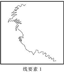 | 道路 | 28.08°N,103.57°E | 18 877.36 | 该地区山高坡陡,峡长谷深,地形地貌复杂;道路数据为盘山公路,局部蜿蜒曲折,局部平坦开阔,具备明显异质性 |
| — | ||||
| 28.03°N,103.63°E | ||||
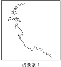 | 道路 | 27.73°N,103.88°E | 30 271.45 | |
| — | ||||
| 27.68°N,103.93°E | ||||
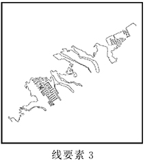 | 海岸线 | 29.22°N,95.00°W | 73 801.66 | 该地区海岸线受到人为活动影响,局部形态规则且密集,局部自然弯曲,具备显著异质性 |
| — | ||||
| 29.18°N,94.93°W | ||||
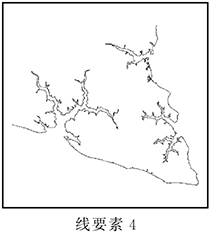 | 海岸线 | 35.47°N,76.69°W | 128 032.76 | 该沿海地区海岸线形态受人为影响较小,自然形成的局部细小分枝状弯曲和局部较大弯曲,数据具备明显异质性 |
| — | ||||
| 35.38°N,76.57°W | ||||
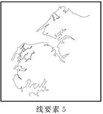 | 海岸线 | 37.66°N,75.89°W | 51 909.13 | 该沿海地区海岸线形态受人为影响较小,自然形成局部密集细小弯曲和局部较大弯曲,数据具备明显异质性 |
| — | ||||
| 37.63°N,75.85°W |
| [1] | 翟仁健, 武芳, 朱丽, 等. 曲线形态的结构化表达[J]. 测绘学报, 2009, 38(2):175-182. |
| ZHAI Renjian, WU Fang, ZHU Li, et al. Structured representation of curve shape[J]. Acta Geodaetica et Cartographica Sinica, 2009, 38(2):175-182. | |
| [2] | 朱鲲鹏, 武芳, 陈波, 等. 基于约束条件的线要素化简算法质量评估[J]. 测绘科学, 2007, 32(3):28-30, 192. |
| ZHU Kunpeng, WU Fang, CHEN Bo, et al. Quality assessment of linear features' simplification algorithms based on constraint conditions[J]. Science of Surveying and Mapping, 2007, 32(3):28-30, 192. | |
| [3] | 武芳, 巩现勇, 杜佳威. 地图制图综合回顾与前望[J]. 测绘学报, 2017, 46(10):1645-1664.DOI:10.11947/j.AGCS.2017.20170287. |
| WU Fang, GONG Xianyong, DU Jiawei. Overview of the research progress in automated map generalization[J]. Acta Geodaetica et Cartographica Sinica, 2017, 46(10):1645-1664.DOI:10.11947/j.AGCS.2017.20170287. | |
| [4] | SKOPELITI A, TSOULOS L. On the parametric description of the shape of the cartographic line[J]. Cartographica: the International Journal for Geographic Information and Geovisualization, 1999, 36(3):53-65. |
| [5] | STANĚK K, ŠILHÁK P, RYGLOVÁ A. A graphical generalization of localized morphological discontinuities on medium-scale state topographic maps[J]. Journal of Geovisualization and Spatial Analysis, 2022, 6(2):20. |
| [6] | 魏泓丞, 张立华, 唐露露, 等. 顾及局部差异的航海图线要素复杂度度量[J]. 测绘学报, 2022, 51(9):1959-1968.DOI:10.11947/j.AGCS.2022.20210129. |
| WEI Hongcheng, ZHANG Lihua, TANG Lulu, et al. Complexity measurement of line element on nautical chart considering local difference[J]. Acta Geodaetica et Cartographica Sinica, 2022, 51(9):1959-1968.DOI:10.11947/j.AGCS.2022.20210129. | |
| [7] | 杨敏, 陈果, 李连营, 等. 序列卷积神经网络支持下线状地图目标的分段方法[J]. 测绘学报, 2023, 52(1):108-116.DOI:10.11947/j.AGCS.2023.20210317. |
| YANG Min, CHEN Guo, LI Lianying, et al. Segmentation of linear map objects using sequential convolutional neural network[J]. Acta Geodaetica et Cartographica Sinica, 2023, 52(1):108-116.DOI:10.11947/j.AGCS.2023.20210317. | |
| [8] | 肖天元, 刘鹏程, 艾廷华, 等. 一种傅里叶信息度量的曲线分形描述与多尺度表达方法[J]. 武汉大学学报(信息科学版), 2020, 45(1):119-125. |
| XIAO Tianyuan, LIU Pengcheng, AI Tinghua, et al. A fractal description and multi-scale expression method of Fourier information metrics[J]. Geomatics and Information Science of Wuhan University, 2020, 45(1):119-125. | |
| [9] | 刘鹏程, 肖天元, 肖佳, 等. 曲线多尺度表达的Head-Tail信息量分割法[J]. 测绘学报, 2020, 49(7):921-933.DOI:10.11947/j.AGCS.2020.20200004. |
| LIU Pengcheng, XIAO Tianyuan, XIAO Jia, et al. A Head-Tail information break method oriented to multi-scale representation of polyline[J]. Acta Geodaetica et Cartographica Sinica, 2020, 49(7):921-933.DOI:10.11947/j.AGCS.2020.20200004. | |
| [10] | 刘慧敏, 樊子德, 邓敏, 等. 地图上等高线信息度量的层次方法研究[J]. 测绘学报, 2012, 41(5):777-783. |
| LIU Huimin, FAN Zide, DENG Min, et al. A hierarchical approach to measuring the information content of the contours in a map[J]. Acta Geodaetica et Cartographica Sinica, 2012, 41(5):777-783. | |
| [11] | 季宏超, 董箭, 李树军, 等. 顾及形态差异的TIN-DDM地形复杂度度量方法[J]. 测绘学报, 2023, 52(6):1010-1021.DOI:10.11947/j.AGCS.2023.20220074. |
| JI Hongchao, DONG Jian, LI Shujun, et al. TIN-DDM terrain complexity measurement method considering topographic forms differences[J]. Acta Geodaetica et Cartographica Sinica, 2023, 52(6):1010-1021.DOI:10.11947/j.AGCS.2023.20220074. | |
| [12] | 程绵绵, 孙群, 徐立, 等. 面轮廓线相似性和复杂性度量及在化简中的应用[J]. 测绘学报, 2019, 48(4):489-501.DOI:10.11947/j.AGCS.2019.20180124. |
| CHENG Mianmian, SUN Qun, XU Li, et al. Polygon contour similarity and complexity measurement and application in simplification[J]. Acta Geodaetica et Cartographica Sinica, 2019, 48(4):489-501.DOI:10.11947/j.AGCS.2019.20180124. | |
| [13] | LIU Minshi, HE Guifang, LONG Yi. A semantics-based trajectory segmentation simplification method[J]. Journal of Geovisualization and Spatial Analysis, 2021, 5(2):19. |
| [14] | BALBOA J L G, LÓPEZ F J A. Sinuosity pattern recognition of road features for segmentation purposes in cartographic generalization[J]. Pattern Recognition, 2009, 42(9):2150-2159. |
| [15] | 刘鹏程, 杨琴. 贝叶斯模型下面向地图表达的海岸线分段模型[J]. 计算机工程与应用, 2016, 52(22):174-179. |
| LIU Pengcheng, YANG Qin. Coastline segment model research for map generalization based on Bayesian method[J]. Computer Engineering and Applications, 2016, 52(22):174-179. | |
| [16] | DU Jiawei, WU Fang, XING Ruixing, et al. Segmentation and sampling method for complex polyline generalization based on a generative adversarial network[J]. Geocarto International, 2022, 37(14):4158-4180. |
| [17] | MITROPOULOS V, NAKOS B. A methodology on natural occurring lines segmentation and generalization[C]//Proceedings of the 14th ICA Workshop on Generalisation and Multiple Representation. Paris: ICA, 2011. |
| [18] | 陈军, 刘万增, 武昊, 等. 智能化测绘的基本问题与发展方向[J]. 测绘学报, 2021, 50(8):995-1005.DOI:10.11947/j.AGCS.2021.20210235. |
| CHEN Jun, LIU Wanzeng, WU Hao, et al. Smart surveying and mapping: fundamental issues and research agenda[J]. Acta Geodaetica et Cartographica Sinica, 2021, 50(8):995-1005.DOI:10.11947/j.AGCS.2021.20210235. | |
| [19] | 郝彤, 王晓峰, 冯甜甜, 等. 地球系统多尺度关键区域与关键过程的智能化测绘[J]. 测绘学报, 2021, 50(8):1084-1095.DOI:10.11947/j.AGCS.2021.20210109. |
| HAO Tong, WANG Xiaofeng, FENG Tiantian, et al. Intelligent and multi-scale surveying of key areas and processes of the Earth system[J]. Acta Geodaetica et Cartographica Sinica, 2021, 50(8):1084-1095.DOI:10.11947/j.AGCS.2021.20210109. | |
| [20] | 陈军, 艾廷华, 闫利, 等. 智能化测绘的混合计算范式与方法研究[J/OL]. 测绘学报: 1-19 [2024-05-25].http://kns.cnki.net/kcms/detail/11.2089.P.20240415.1049.002.html. |
| CHEN Jun, AI Tinghua, YAN Li, et al. Hybrid computational paradigm and methods for intelligentized surveying and mapping[J/OL]. Acta Geodaetica et Cartographica Sinica: 1-19 [2024-05-25]. http://kns.cnki.net/kcms/detail/11.2089.P.20240415.1049.002.html. | |
| [21] | 安晓亚, 成晓强. 矢量曲线的视觉清晰度及在网络地图综合中的应用[J]. 测绘学报, 2020, 49(2):245-255.DOI:10.11947/j.AGCS.2020.20190280. |
| AN Xiaoya, CHENG Xiaoqiang. Visual clarity of vector curve and its application in web map generalization[J]. Acta Geodaetica et Cartographica Sinica, 2020, 49(2):245-255. DOI:10.11947/j.AGCS.2020.20190280. | |
| [22] | SHEA K, MASTER R M. Cartographic generalization in a digital environment: when and how to generalize[C]//Proceedings of 1989 Auto-Carto 9. [S.l.]: IEEE, 1989. |
| [23] | 唐炉亮, 阚子涵, 刘汇慧, 等. 网络空间中线要素的核密度估计方法[J]. 测绘学报, 2017, 46(1):107-113.DOI:10.11947/j.AGCS.2017.20150158. |
| TANG Luliang, KAN Zihan, LIU Huihui, et al. A kernel density estimation method for linear features in network space[J]. Acta Geodaetica et Cartographica Sinica, 2017, 46(1):107-113.DOI:10.11947/j.AGCS.2017.20150158. | |
| [24] | 禹文豪, 艾廷华. 核密度估计法支持下的网络空间POI点可视化与分析[J]. 测绘学报, 2015, 44(1):82-90.DOI:10.11947/j.AGCS.2015.20130538. |
| YU Wenhao, AI Tinghua. The visualization and analysis of POI features under network space supported by kernel density estimation[J]. Acta Geodaetica et Cartographica Sinica, 2015, 44(1):82-90.DOI:10.11947/j.AGCS.2015.20130538. | |
| [25] | ANDERSON T K. Kernel density estimation and K-means clustering to profile road accident hotspots[J]. Accident Analysis & Prevention, 2009, 41(3):359-364. |
| [26] | BÍL M, ANDRÁŠIK R, JANOŠKA Z. Identification of hazardous road locations of traffic accidents by means of kernel density estimation and cluster significance evaluation[J]. Accident Analysis & Prevention, 2013, 55:265-273. |
| [27] | FLAHAUT B, MOUCHART M, SAN MARTIN E, et al. The local spatial autocorrelation and the kernel method for identifying black zones: a comparative approach[J]. Accident Analysis & Prevention, 2003, 35(6):991-1004. |
| [28] | WANG Zuyuan, GINZLER C, WASER L T. Assessing structural changes at the forest edge using kernel density estimation[J]. Forest Ecology and Management, 2020, 456:117639. |
| [1] | 方帅, 刘加恩, 张晶. 自适应参考特征引入与多尺度特征聚合的时空融合算法[J]. 测绘学报, 2025, 54(8): 1476-1488. |
| [2] | 万杰, 谢忠, 徐永洋, 陶留锋. 面向城市道路场景的车载LiDAR点云语义分割U形图卷积网络方法[J]. 测绘学报, 2025, 54(7): 1280-1293. |
| [3] | 吴华意, 董广胜, 李锐. 虚拟轨迹:概念特征和研究框架[J]. 测绘学报, 2025, 54(6): 967-981. |
| [4] | 林浩嘉, 郭仁忠, 贺彪, 蒯希, 马丁, 李程鹏. 视觉感知导向的实景三维建筑场景LOD自适应可视化[J]. 测绘学报, 2025, 54(6): 1054-1070. |
| [5] | 董子博, 王竞雪, 卜丽静, 房琳, 许峥辉. MAFNet:基于多尺度空洞融合网络的遥感影像建筑物提取方法[J]. 测绘学报, 2025, 54(6): 1094-1106. |
| [6] | 高永刚, 刘雨婷, 徐涵秋. 基于Landsat长时间序列影像的城市生态品质时空演变及驱动因素分析[J]. 测绘学报, 2025, 54(3): 510-522. |
| [7] | 苏友能, 徐青, 孙群, 朱新铭, 张付兵, 刘波. 邻近边约束下的建筑物自动合并方法[J]. 测绘学报, 2025, 54(3): 563-576. |
| [8] | 黄哲琨, 钱海忠, 蔡中祥, 王骁, 王俊威, 孔令辉. 基于图神经网络的多尺度网状河系分类匹配方法[J]. 测绘学报, 2025, 54(2): 371-384. |
| [9] | 鄢薪, 慎利, 潘俊杰, 戴延帅, 王继成, 郑晓莉, 李志林. 多尺度特征融合与空间优化的弱监督高分遥感建筑变化检测[J]. 测绘学报, 2024, 53(8): 1586-1597. |
| [10] | 徐涛, 杨元维, 高贤君, 王志威, 潘越, 李少华, 许磊, 王艳军, 刘波, 余静, 吴凤敏, 孙浩宇. 融合图卷积与多尺度特征的接触网点云语义分割[J]. 测绘学报, 2024, 53(8): 1624-1633. |
| [11] | 杨军, 解恒静, 范红超, 闫浩文. 遥感影像目标检测多尺度熵神经网络架构搜索[J]. 测绘学报, 2024, 53(7): 1384-1400. |
| [12] | 刘焕玲, 杨蔚然, 张放, 文汉江, 胡敏章, 蒋涛, 蔺文奇, 黎晨曦. 海域重力异常模型的多尺度分析[J]. 测绘学报, 2024, 53(2): 274-285. |
| [13] | 孙根云, 孙超, 张爱竹. 融合多尺度与边缘特征的道路提取网络[J]. 测绘学报, 2024, 53(12): 2233-2243. |
| [14] | 庞世燕, 郝京京, 左志奇, 兰晶晶, 胡翔云. 融合密集连接和自注意力机制的高分辨率遥感影像变化检测方法[J]. 测绘学报, 2024, 53(12): 2244-2253. |
| [15] | 江宝得, 黄威, 许少芬, 巫勇. 融合分散自适应注意力机制的多尺度遥感影像建筑物实例细化提取[J]. 测绘学报, 2023, 52(9): 1504-1514. |
| 阅读次数 | ||||||
|
全文 |
|
|||||
|
摘要 |
|
|||||