


测绘学报 ›› 2024, Vol. 53 ›› Issue (11): 2111-2124.doi: 10.11947/j.AGCS.2024.20230360
颉旭康1,2,3( ), 李伟1,2,3()
收稿日期:2023-09-08
出版日期:2024-12-13
发布日期:2024-12-13
通讯作者:
李伟
E-mail:11210877@stu.lzjtu.edu.cn;geosci.wli@lzjtu.edu.cn
作者简介:颉旭康(1999—),男,硕士,研究方向为卫星大地测量与水文学。 E-mail:11210877@stu.lzjtu.edu.cn
基金资助:
Xukang XIE1,2,3(), Wei LI1,2,3()
Received:2023-09-08
Online:2024-12-13
Published:2024-12-13
Contact:
Wei LI
E-mail:11210877@stu.lzjtu.edu.cn;geosci.wli@lzjtu.edu.cn
About author:XIE Xukang (1999—), male, master, majors in satellite geodesy and hydrology. E-mail: 11210877@stu.lzjtu.edu.cn
Supported by:摘要:
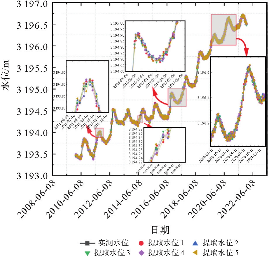
利用卫星测高技术提取湖库水位信息时,融合多种卫星测高数据构建长时序和高精度的水位尤为重要。本文以青海湖为例,选取Envisat、SARAL、Sentinel-3A和Sentinel-3B这4颗测高卫星数据,基于不同数据源结果及其特征构建了20 a时长的数据集,提出了融合自适应定权和偏差匹配的多源卫星测高数据水位提取算法,其中自适应定权能根据不同场景选择适当的改正算法模型,并为多源测高参数确定不同的权重参数,从而统一数据。偏差匹配方法则最大程度将定性数据定量化,使水位提取更准确。同时建立了人工智能框架实现了水位提取的自动化和一体化。试验显示,经过自适应定权的多源测高特征值可以被合理分类且具有强相关性,可为构建长时序水位信息提供整体高精度的基础数据;结合偏差匹配方法,以天为尺度提取的水位和实测水位相关系数R2在0.9以上,若将相关系数R2阈值设为0.8,可单次提取5个月时长的水位。结合单天提取和多天提取提出长期提取方法,构建了12 a的长时序水位,其相关系数R2在0.9以上,平均绝对误差(MAE)值在1.5~2.0 cm之间,均方根误差(RMSE)值在2.0~2.5 cm之间,成功构建了长时序和高精度的水位。鉴于此,该数据处理算法和构建的模型在水位信息提取及预测方面体现出一定的实用价值,其研究成果也印证了人工智能与卫星测高相结合在小尺度水域构建长时序高精度水位的可行性。
中图分类号:
颉旭康, 李伟. 融合自适应定权和偏差匹配的多源卫星测高数据水位提取算法[J]. 测绘学报, 2024, 53(11): 2111-2124.
Xukang XIE, Wei LI. Water level extraction algorithm based on adaptive weighting and deviation matching of multi-source satellite altimetry data[J]. Acta Geodaetica et Cartographica Sinica, 2024, 53(11): 2111-2124.

图1
研究区域和测高卫星数据的时空信息"
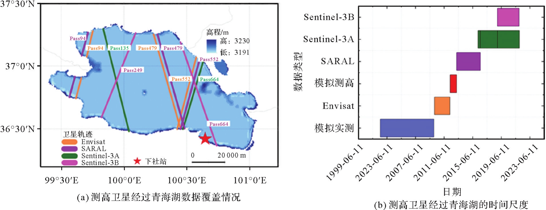
表1
试验数据集"
| 数据来源 | 数据频率/Hz | 时间尺度 | 模型修正 |
|---|---|---|---|
| Sentinel-3A | 20 | 2016-03-09—2021-12-22 | 多种重跟踪算法 |
| Sentinel-3B | 20 | 2018-11-28—2021-12-09 | 多种重跟踪算法 |
| Envisat | 20 | 2010-01-28—2010-10-22 | 多种重跟踪算法 |
| Envisat | 20 | 2010-11-05—2012-03-29 | 多种重跟踪算法 |
| Envisat | 20 | 2002-07-04—2009-12-27 | 模拟实测数据 |
| SARAL | 40 | 2013-03-14—2016-07-02 | 多种重跟踪算法 |
| 模拟数据 | 无 | 2012-04-10—2013-03-10 | 模拟测高数据 |
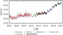
图2
高程系统局部融合后的青海湖2002—2021年的水位"
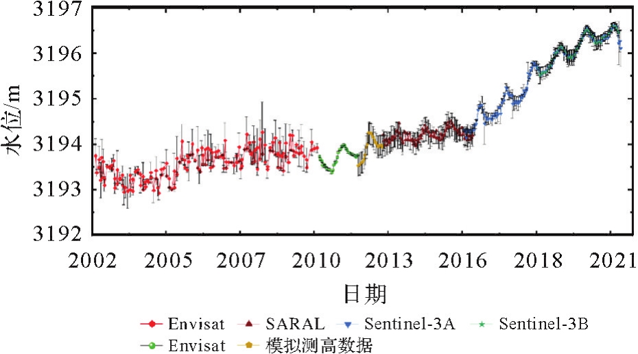
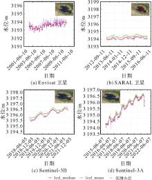
图3
4颗测高卫星数据反演青海湖水位"
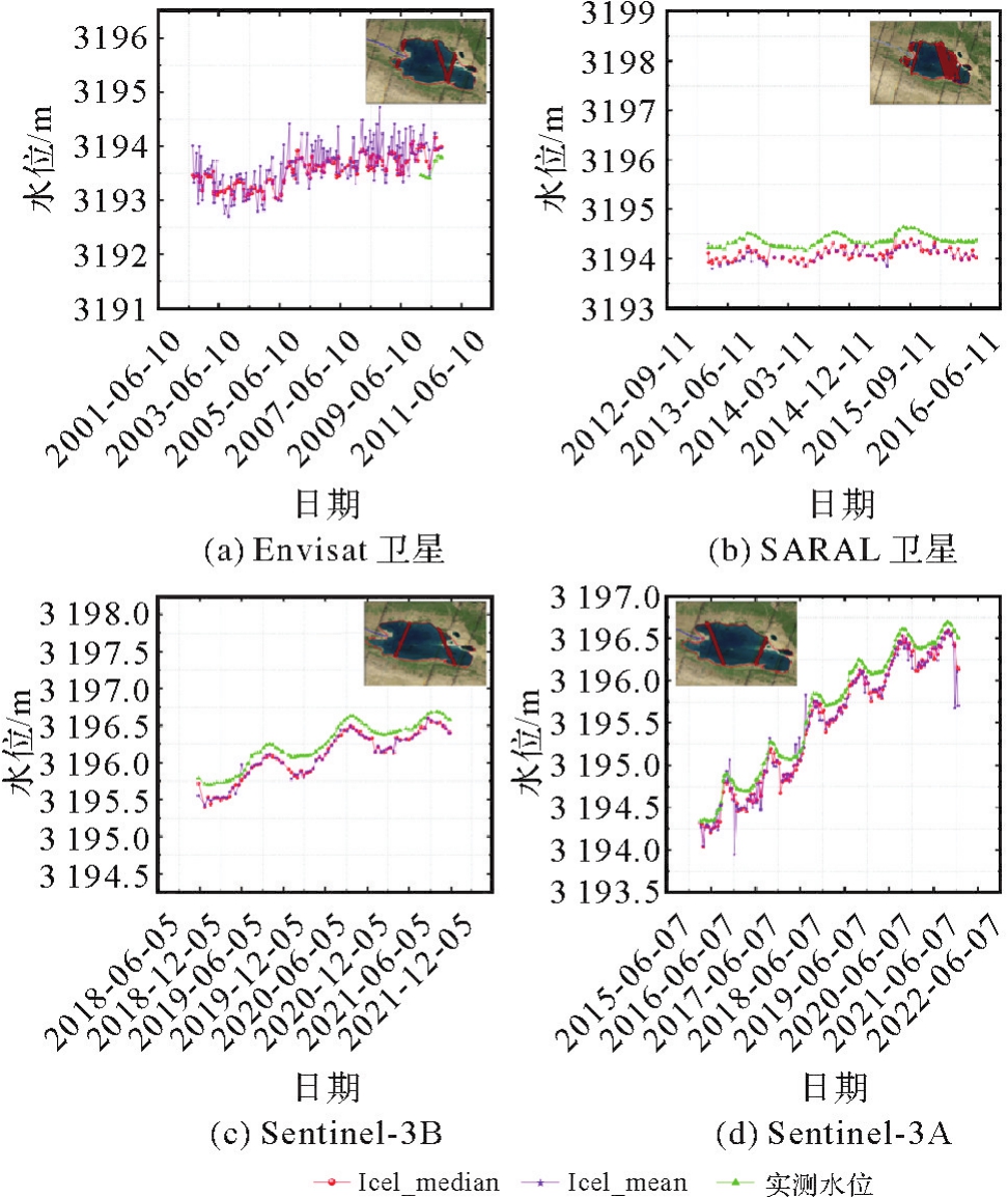
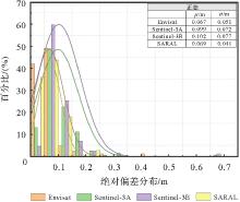
图4
中位值数据的绝对偏差分布"

表2
总方差解释"
| 主成分 | 初始特征值 | 提取载荷平方和 | 旋转载荷平方和总计 | ||||
|---|---|---|---|---|---|---|---|
| 总计 | 方差/(%) | 累积/(%) | 总计 | 方差/(%) | 累积/(%) | ||
| 1 | 8.948 | 35.791 | 35.791 | 8.948 | 35.791 | 35.791 | 8.486 |
| 2 | 4.557 | 18.228 | 54.019 | 4.557 | 18.228 | 54.019 | 4.856 |
| 3 | 3.382 | 13.526 | 67.545 | 3.382 | 13.526 | 67.545 | 3.104 |
| 4 | 1.532 | 6.127 | 73.673 | 1.532 | 6.127 | 73.673 | 1.690 |
| 5 | 1.352 | 5.407 | 79.080 | 1.352 | 5.407 | 79.080 | 1.531 |
| 6 | 1.169 | 4.674 | 83.754 | 1.169 | 4.674 | 83.754 | 1.272 |
表3
6个主成分的详解"
| 主成分 | 参数 | 归属 | 特征 | 载荷 | 选取 |
|---|---|---|---|---|---|
| peakiness_1_plrm_ku | 波峰 | 限制类因素 | 0.959 | 是 | |
| peakiness_2_c | 波峰 | 限制类因素 | 0.953 | 是 | |
| peakiness_1_c | 波峰 | 限制类因素 | 0.953 | 是 | |
| tb_365 | 表面亮温 | 外界因素 | 0.928 | 是 | |
| tb_238 | 表面亮温 | 外界因素 | 0.925 | 是 | |
| 1 | peakiness_1_plrm_ku | 波峰 | 限制类因素 | 0.922 | 是 |
| sig0_ocog_c | 后向散射系数 | 限制类因素 | 0.921 | 是 | |
| sig0_ice_plrm_ku | 后向散射系数 | 限制类因素 | 0.827 | 否 | |
| sig0_ice_c | 后向散射系数 | 限制类因素 | 0.718 | 否 | |
| mod_dry | 干对流层 | 传播修正 | 0.625 | 是 | |
| sig0_ocog_ku | 后向散射系数 | 限制类因素 | 0.606 | 否 | |
| data | 日期 | 时间特征 | 0.952 | 是 | |
| cycle | 周期 | 识别特征 | 0.951 | 是 | |
| 2 | in_situ | 实测水位值 | 标签值 | 0.920 | 是 |
| num | 时序 | 识别特征 | 0.789 | 是 | |
| sig0_ocog_ku | 后向散射系数 | 限制类因素 | -0.694 | 否 | |
| sig0_ice_sheet_ku | 后向散射系数 | 限制类因素 | -0.743 | 否 | |
| geoid | 大地水准面 | 限制类因素 | 0.988 | 是 | |
| 3 | lon | 经度 | 限制类因素 | 0.986 | 是 |
| lat | 纬度 | 限制类因素 | -0.993 | 否 | |
| 4 | iono_cor_gim | 电离层 | 传播修正 | 0.892 | 是 |
| 5 | ASOE | 独热编码 | 识别特征 | 0.970 | 是 |
| 6 | mod_wet | 湿对流层 | 传播修正 | 0.653 | 是 |
图5
融合自适应定权和偏差匹配方法的人工智能框架"
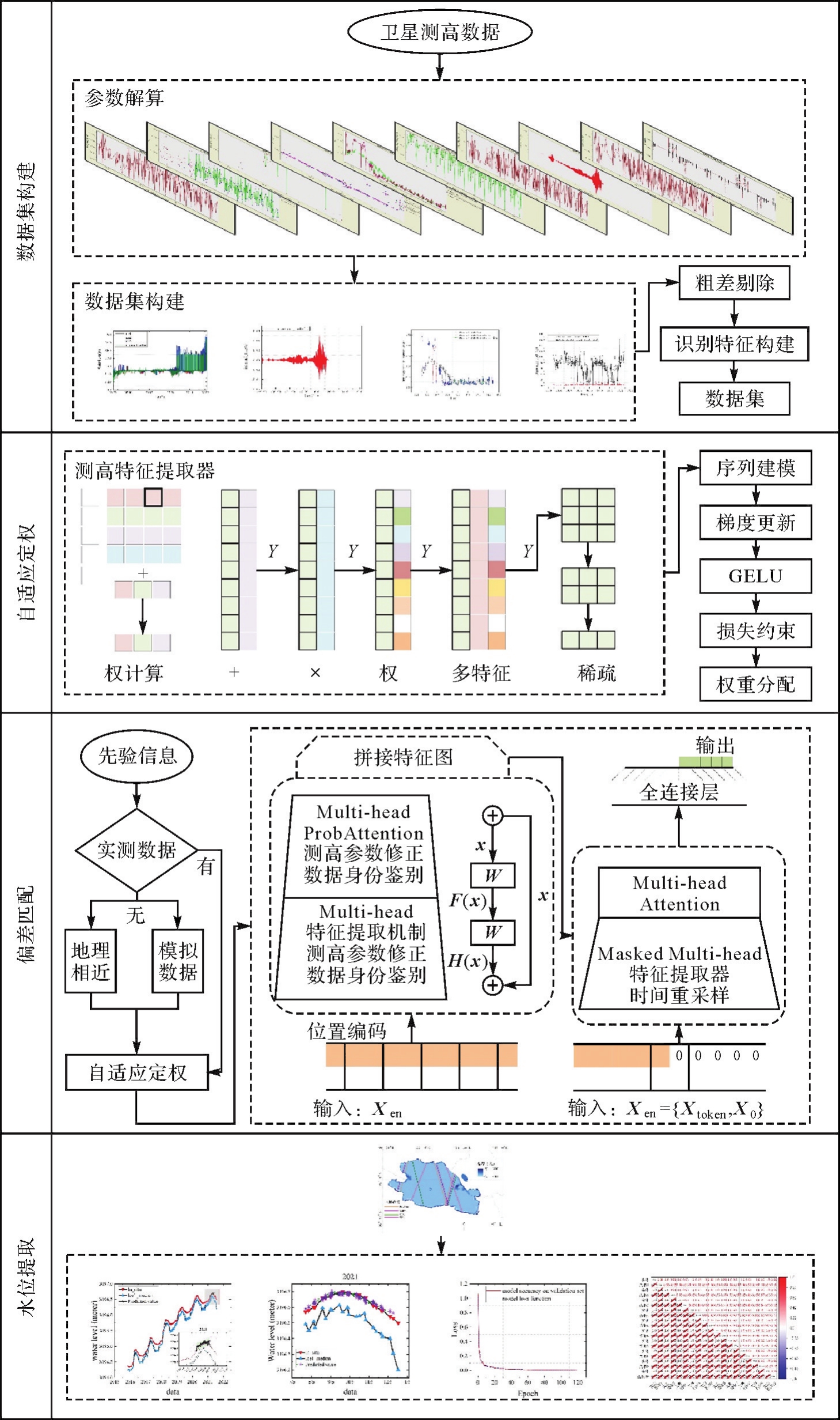
图6
单天提取与重跟踪算法水位对比"
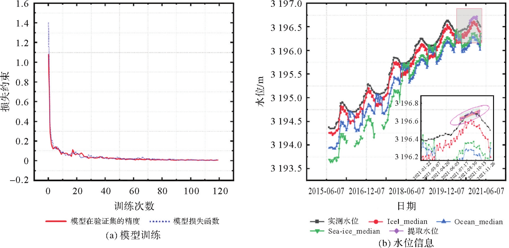
表4
单天水位提取精度评价"
| 单天算法 | 时间间隔/d | MAE/cm | RMSE/cm | R2 |
|---|---|---|---|---|
| Ice1 | Pass间隔天数 | 14.38 | 15.29 | 0.99 |
| Ocean | Pass间隔天数 | 34.21 | 37.29 | 0.95 |
| Sea-ice | Pass间隔天数 | 67.89 | 44.54 | 0.95 |
| 本文算法 | 1 | 1.95 | 2.19 | 0.91 |
表5
4颗测高卫星的时间间隔"
| 测高卫星 | 卫星周期/d | Pass轨迹号 | Pass间隔天数/d |
|---|---|---|---|
| Envisat | 35 | 94、479、552 | 3、13、16、19、22、32 |
| SARAL | 35 | 21、94、479、552 | 3、13、16、19 |
| S3A | 27 | 135、664 | 8、19、27 |
| S3B | 27 | 249、664 | 12、15、27 |
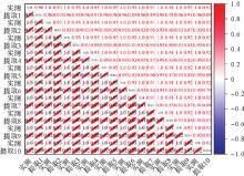
图7
单天提取水位与实测水位的相关性热图"
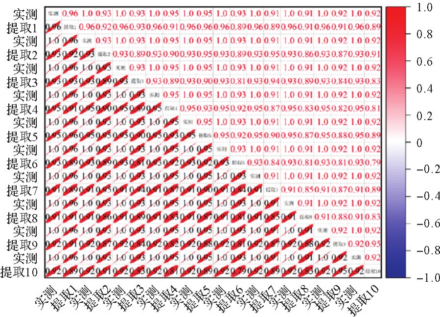
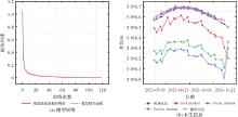
图8
多天水位提取与重跟踪算法水位对比"
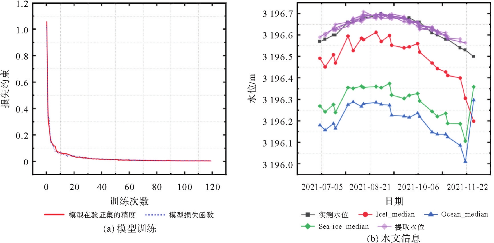
表6
多天水位提取精度评价"
| 多天算法 | 时间间隔/d | MAE/cm | RMSE/cm | R2 |
|---|---|---|---|---|
| Ice1 | Pass间隔天数 | 13.19 | 14.11 | 0.84 |
| Ocean | Pass间隔天数 | 42.16 | 42.54 | 0.41 |
| Sea-ice | Pass间隔天数 | 33.71 | 34.10 | 0.47 |
| 本文算法 | Pass间隔天数 | 1.85 | 2.58 | 0.85 |
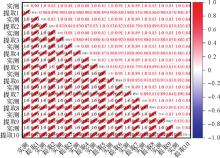
图9
多天提取水位与实测水位的相关性热图"
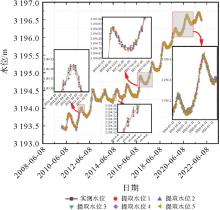
图10
使用长期提取方法构建的青海湖2010—2022年长时序高精度水位"
| [1] | 姜丽光, 刘俊, 张星星. 基于卫星雷达测高技术的湖库动态监测理论、方法和研究进展[J]. 遥感学报, 2022, 26(1): 104-114. |
| JIANG Liguang, LIU Jun, ZHANG Xingxing. Monitoring lakes and reservoirs using satellite radar altimetry: theory, methods, and progresses[J]. National Remote Sensing Bulletin, 2022, 26(1): 104-114. | |
| [2] | JIANG Liguang, NIELSEN K, ANDERSEN O B, et al. CryoSat-2 radar altimetry for monitoring freshwater resources of China[J]. Remote Sensing of Environment, 2017, 200: 125-139. |
| [3] | DU Bin, LI Jiancheng, JIN Taoyong, et al. Synthesis analysis of swot karin-derived water surface heights and local cross-calibration of the baseline roll knowledge error over Lake Baikal[J]. Earth and Space Science, 2021, 8(11): e2021EA001990. |
| [4] | HOU Jiawei, VAN DIJK A I J M, RENZULLO L J, et al. GloLakes: water storage dynamics for 27 000 lakes globally from 1984 to present derived from satellite altimetry and optical imaging[J]. Earth System Science Data, 2024, 16(1): 201-218. |
| [5] | JIANG Liguang, NIELSEN K, ANDERSEN O B. Improvements in mountain lake monitoring from satellite altimetry over the past 30 years-lessons learned from Tibetan Lakes[J]. Remote Sensing of Environment, 2023, 295: 113702. |
| [6] | JIANG Liguang, ZHAO Yanan, NIELSEN K, et al. Near real-time altimetry for river monitoring-a global assessment of Sentinel-3[J]. Environmental Research Letters, 2023, 18(7): 074017. |
| [7] | ZWALLY H J, ROBBINS J W. New insights to antarctic glacial history and earth dynamics from integration of satellite gravimetry and altimetry measurements of mass changes[C]//Proceedings of 2019 AGU Fall Meeting Abstracts. San Francisco: [s.n.], 2019: C21E-1503. |
| [8] | ZWALLY H J, ROBBINS J W, LUTHCKE S B, et al. Mass balance of the Antarctic ice sheet 1992—2016: reconciling results from GRACE gravimetry with ICESat, ERS1/2 and EnviSat altimetry[J]. Journal of Glaciology, 2021, 67(263): 533-559. |
| [9] | YANG Lei, LIU Min, LIU Na, et al. Recovering bathymetry from satellite altimetry-derived gravity by fully connected deep neural network[J]. IEEE Geoscience and Remote Sensing Letter, 2023, 20: 1-5. |
| [10] | ZHU Chengcheng, YANG Lei, BIAN Hongwei, et al. Recovering gravity from satellite altimetry data using deep learning network[J]. IEEE Transactions on Geoscience and Remote Sensing, 2023, 61: 1-11. |
| [11] | ABDALLA S, KOLAHCHI A A, ABLAIN M, et al. Altimetry for the future: building on 25 years of progress[J]. Advances in Space Research, 2021, 68(2): 319-363. |
| [12] | FABLET R, VERRON J, MOURRE B, et al. Improving mesoscale altimetric data from a multitracer convolutional processing of standard satellite-derived products[J]. IEEE Transactions on Geoscience and Remote Sensing, 2018, 56(5): 2518-2525. |
| [13] | 汪海洪, 罗志才, 杨元德, 等. 基于波形分类的近海卫星测高数据自适应重跟踪方法[J]. 测绘学报, 2012, 41(5): 729-734. |
| WANG Haihong, LUO Zhicai, YANG Yuande, et al. An adaptive retracking method for coastal altimeter data based on waveform classification[J]. Acta Geodaetica et Cartographica Sinica, 2012, 41(5): 729-734. | |
| [14] | BAO Lifeng, LU Yang, WANG Yong. Improved retracking algorithm for oceanic altimeter waveforms[J]. Progress in Natural Science, 2009, 19(2): 195-203. |
| [15] | SOTIROPOULOU K F, VAVATSIKOS A P. A decision-making framework for spatial multicriteria suitability analysis using promethee ii and k nearest neighbor machine learning models[J]. Journal of Geovisualization and Spatial Analysis, 2023, 7(2): 20. |
| [16] | 金涛勇, 李建成, 姜卫平, 等. 基于多源卫星测高数据的新一代全球平均海面高模型[J]. 测绘学报, 2011, 40(6): 723-729. |
| JIN Taoyong, LI Jiancheng, JIANG Weiping, et al. The new generation of global mean sea surface height model based on multi-altimetric data[J]. Acta Geodaetica et Cartographica Sinica, 2011, 40(6): 723-729. | |
| [17] | 李大炜, 李建成, 金涛勇, 等. 利用多代卫星测高资料监测1993~2011年全球海平面变化[J]. 武汉大学学报(信息科学版), 2012, 37(12): 1421-1424. |
| LI Dawei, LI Jiancheng, JIN Taoyong, et al. Monitoring global sea level change from 1993 to 2011 using topex and jason altimeter missions[J], Geomatics and Information Science of Wuhan University, 2012, 37(12): 1421-1424. | |
| [18] | YAO Fangfang, LIVNEH B, RAJAGOPALAN B, et al. Satellites reveal widespread decline in global lake water storage[J]. Science, 2023, 380(6646): 743-749. |
| [19] | 姜卫平, 褚永海, 李建成, 等. 利用ENVISAT测高数据监测青海湖水位变化[J]. 武汉大学学报(信息科学版), 2008, 33(1): 64-67. |
| JIANG Weiping, CHU Yonghai, LI Jiancheng, et al. Water level variation of Qinghai Lake from altimeteric data[J]. Geomatics and Information Science of Wuhan University, 2008, 33(1): 64-67. | |
| [20] | HUANG Qi, LONG Di, DU Mingda, et al. An improved approach to monitoring Brahmaputra River water levels using retracked altimetry data[J]. Remote Sensing of Environment, 2018, 211: 112-128. |
| [21] | OKADA S, OHZEKI M, TAGUCHI S. Efficient partition of integer optimization problems with one-hot encoding[J]. Scientific Reports, 2019, 9(1): 13036. |
| [22] | 褚永海, 李建成, 金涛勇, 等. T/P雷达高度计后向散射系数陆地表面观测应用[J]. 大地测量与地球动力学, 2009, 29(3): 104-108. |
| CHU Yonghai, LI Jiancheng, JIN Taoyong, et al. Application of T/P altimeter backscatter data to land surface observation[J]. Journal of Geodesy and Geodynamics, 2009, 29(3): 104-108. | |
| [23] | 孙明智, 刘新, 汪海洪, 等. 多源卫星测高数据监测拉昂错1992年—2020年水位变化[J]. 遥感学报, 2022, 26(1): 126-137. |
| SUN Mingzhi, LIU Xin, WANG Haihong, et al. Monitoring lake level change in La-ang Co from 1992 to 2020 using multi-altimeter data[J]. National Remote Sensing Bulletin, 2022, 26(1): 126-137. | |
| [24] | 郭金运, 孙佳龙, 常晓涛, 等. TOPEX/Poseidon卫星监测博斯腾湖水位变及其与NINO3 SST的相关性分析[J]. 测绘学报, 2010, 39(3): 221-226. |
| GUO Jinyun, SUN Jialong, CHANG Xiaotao, et al. Water level variation of bosten lake monitored with TOPEX/Poseidon and its correlation with NIN03 SST[J]. Acta Geodaetica et Cartographica Sinica, 2010, 39(3): 221-226. | |
| [25] | THARA D K, PREMASUDHA B G, XIONG Fan. Auto-detection of epileptic seizure events using deep neural network with different feature scaling techniques[J]. Pattern Recognition Letters, 2019, 128: 544-550. |
| [26] | NI Sen, JIA Pengfei, XU Yang, et al. Prediction of CO concentration in different conditions based on Gaussian-TCN[J]. Sensors and Actuators B: Chemical, 2023, 376(Part B): 133010. |
| [27] | GU Jiuxiang, WANG Zhenhua, JASON K, et al. Recent advances in convolutional neural networks[J]. Pattern recognition, 2018, 77: 354-377. |
| [28] | VASWANI A, SHAZEER N, PARMAR N, et al. Attention is all you need[J]. Advances in Neural Information Processing Systems, 2017, 30: 18-27. |
| [29] | ZHOU Haoyi, ZHANG Shanghang, PENG Jieqi, et al. Informer: beyond efficient Transformer for long sequence time-series forecasting[C]//Proceedings of 2021 AAAI Conference on Artificial Intelligence. San Francisco: [s.n.], 2021: 11106-11115. |
| [30] | LI Zewen, LIU Fan, YANG Wenjie, et al. A survey of convolutional neural networks: analysis, applications, and prospects[J]. IEEE Transactions on Neural Networks and Learning Systems, 2021, 33(12): 6999-7019. |
| [31] | HOCHREITER S, SCHMIDHUBER J. Long short-term memory[J]. Neural Computation, 1997, 9(8): 1735-1780. |
| [1] | 祝程程, 李真, 郭金运, 周茂盛, 李婉秋. 基于限定区域的纬度做差法解算宽刈幅测高数据交叉点位置[J]. 测绘学报, 2026, 55(4): 673-683. |
| [2] | 杨小磊, 肖云, 杨丽清, 洪晓东, 郭恩泽, 王翰. 时变重力场反演的改进基线法[J]. 测绘学报, 2026, 55(4): 708-720. |
| [3] | 李洋, 黄海军, 刘素兰, 吴晓辉, 刘琦, 庞琪沛, 吴云龙. 鄱阳湖流域未来百年陆地水储量异常预测及干旱风险评估:基于CMIP6驱动的Transformer-GRU模型[J]. 测绘学报, 2026, 55(4): 721-738. |
| [4] | 杨先圣. 高可用可见光智能定位技术研究[J]. 测绘学报, 2026, 55(4): 753-753. |
| [5] | 耿继军. 基于智能手机多传感器融合的行人室内外定位研究[J]. 测绘学报, 2026, 55(4): 754-754. |
| [6] | 马宏阳. 对流层模型增强的PPP-AR理论方法及在机载导航中的应用研究[J]. 测绘学报, 2026, 55(4): 756-756. |
| [7] | 刘航. 联合地基GNSS和星载GNSS-R的低纬电离层闪烁监测及预报方法研究[J]. 测绘学报, 2026, 55(4): 758-758. |
| [8] | 刘海锋. 基于GNSS无线电掩星的电离层突发E层时空分布研究[J]. 测绘学报, 2026, 55(4): 759-759. |
| [9] | 王家耀, 陈琳, 程士源, 王利军, 熊思奇. 人工智能赋能地图科学数智化[J]. 测绘学报, 2026, 55(3): 381-389. |
| [10] | 吴汤婷, 罗馨语, 卢立果, 刘站科, 超能芳. 基于GNSS和GRACE/GRACE-FO的陕甘宁地区水资源与水文干旱特征时空变化评价[J]. 测绘学报, 2026, 55(3): 439-450. |
| [11] | 马中民, 张双成, 周昕, 刘奇, 刘宁, 王恒利. 顾及地表反射率不确定性的风云三号GNSS-R洪涝监测方法:以8·2广东极端暴雨灾害为例[J]. 测绘学报, 2026, 55(3): 451-464. |
| [12] | 周瑞, 朱锋, 张小红. 基于先验位姿与运动编排的相机惯导外参标定方法[J]. 测绘学报, 2026, 55(3): 465-476. |
| [13] | 刘婧璇, 刘学习, 张克非, 杨超, 吴素芹, 朱守庆, 郭福东. 基于LSTM模型与加权最小二乘组合的日长变化预测方法[J]. 测绘学报, 2026, 55(3): 477-489. |
| [14] | 侯文韬, 肖云, 曹杰, 王宇康, 曹春婷, 王翰. 基于特征加权CatBoost模型的重力卫星反演地下水储量变化降尺度方法[J]. 测绘学报, 2026, 55(3): 490-501. |
| [15] | 徐磊. GNSS区域电离层精细化建模理论与方法研究[J]. 测绘学报, 2026, 55(3): 565-565. |
| 阅读次数 | ||||||
|
全文 |
|
|||||
|
摘要 |
|
|||||