


测绘学报 ›› 2025, Vol. 54 ›› Issue (3): 563-576.doi: 10.11947/j.AGCS.2025.20240138
苏友能1( ), 徐青1(), 孙群1, 朱新铭1, 张付兵1, 刘波2
收稿日期:2024-04-25
出版日期:2025-04-11
发布日期:2025-04-11
通讯作者:
徐青
E-mail:youneng_2000@163.com;xq1982_no.1@163.com
作者简介:苏友能(2000—),男,硕士生,研究方向为地理知识图谱与地图自动综合。 E-mail:youneng_2000@163.com
基金资助:
Youneng SU1(), Qing XU1(), Qun SUN1, Xinming ZHU1, Fubing ZHANG1, Bo LIU2
Received:2024-04-25
Online:2025-04-11
Published:2025-04-11
Contact:
Qing XU
E-mail:youneng_2000@163.com;xq1982_no.1@163.com
About author:SU Youneng (2000—), male, postgraduate, majors in geographic knowledge graph and automatic generalization of maps. E-mail: youneng_2000@163.com
Supported by:摘要:
大比例尺建筑物合并是制图综合领域的一个难点问题。为保持合并前后建筑物形状特征的一致性,本文提出了一种邻近边约束下的建筑物自动合并方法。该方法首先利用Delaunay三角网确定建筑物间的邻近关系,以建筑物最小外接矩形为约束生成建筑物邻近边,并依据建筑物间最小外接矩形的投影占比,划分建筑物空间结构关系为对准型和错位型。然后,提出邻近边交互投影法和邻近边角平分线法,分别用于对准型建筑物和错位型建筑物合并。最后,以上海市建筑物为试验数据,验证了本文方法的有效性。试验结果表明,本文方法能够实现不同结构关系、不同合并阈值下建筑物的有效合并,并且保持了建筑物间的空间结构特征和直角特征。
中图分类号:
苏友能, 徐青, 孙群, 朱新铭, 张付兵, 刘波. 邻近边约束下的建筑物自动合并方法[J]. 测绘学报, 2025, 54(3): 563-576.
Youneng SU, Qing XU, Qun SUN, Xinming ZHU, Fubing ZHANG, Bo LIU. A method for automatic buildings aggregation constrained by proximity edges[J]. Acta Geodaetica et Cartographica Sinica, 2025, 54(3): 563-576.
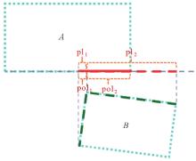
图1
MBR投影"
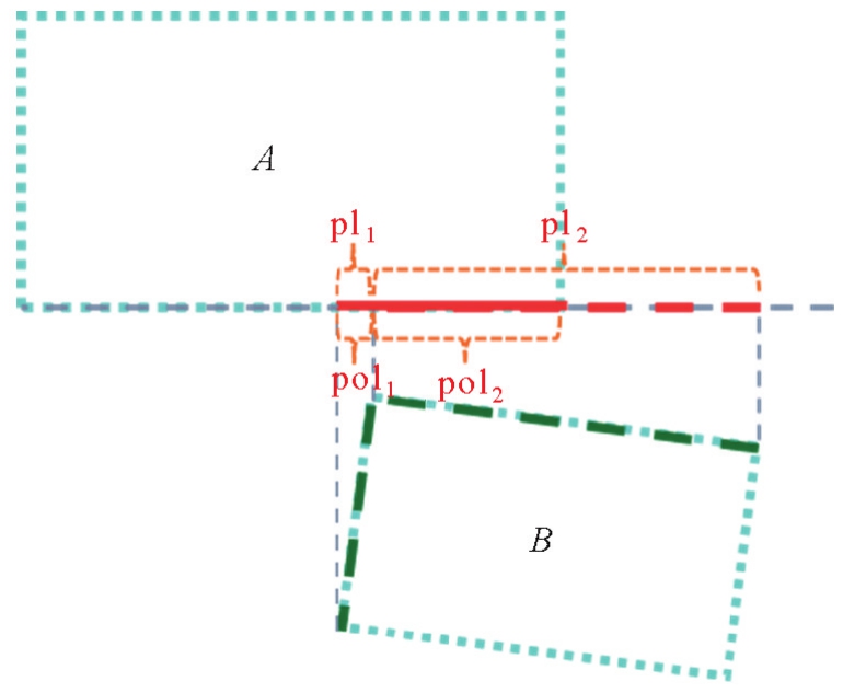
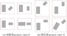
图2
邻近建筑物空间结构关系"
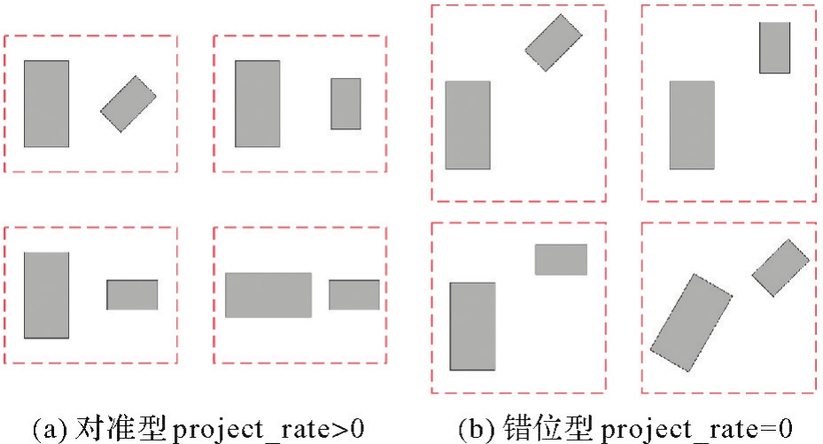
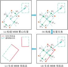
图3
MBR邻近边生成"

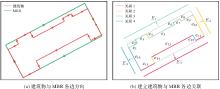
图4
建筑物边分类"
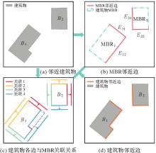
图5
建筑物邻近边生成"
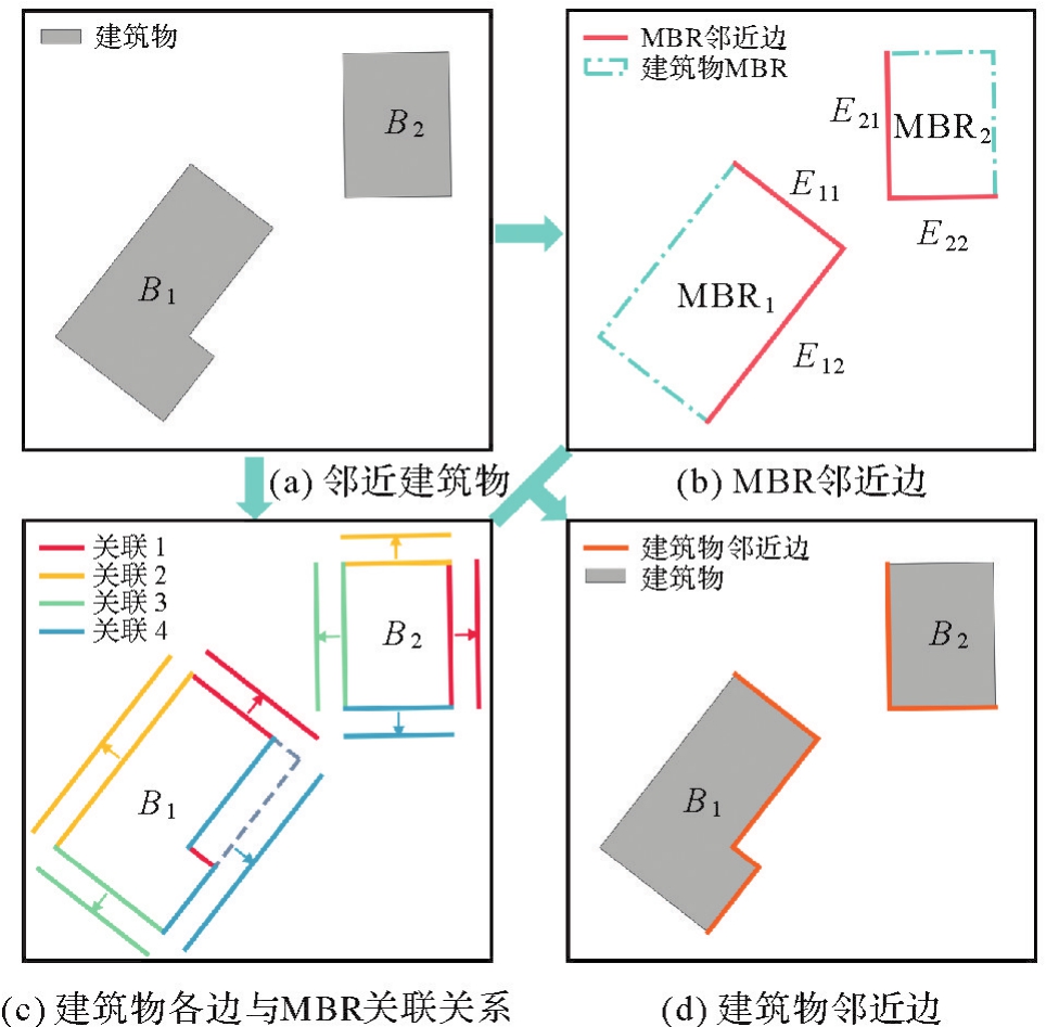
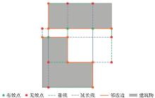
图6
邻近边投影点选择"
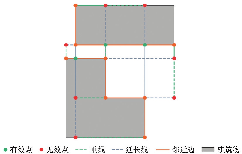
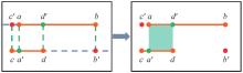
图7
交叉投影下的桥接面生成"
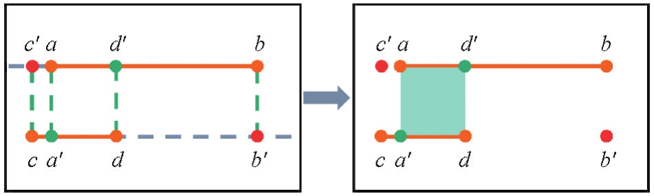
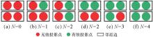
图8
对准型建筑物邻近边投影点分析"
表1
对准型建筑物邻近边的桥接面生成情况"
| 类别 | 邻近边上投影点数量 | 投影点图示 | 桥接面图示 | 是否构建桥接面 |
|---|---|---|---|---|
| Ⅰ | 2 |  |  | 是 |
| Ⅱ | 2 |  |  | 是 |
| Ⅲ | 3 |  |  | 是 |
| Ⅳ | 4 |  |  | 是 |
表2
错位型建筑物邻近边的桥接面生成情况"
| 类别 | 邻近边上交点数量 | 交点图示 | 桥接面图示 | 是否构建桥接面 |
|---|---|---|---|---|
| Ⅰ | 0 |  |  | 否 |
| Ⅱ | 1 |  |  | 是 |
| Ⅲ | 2 |  |  | 是 |
| Ⅳ | 1 |  |  | 是 |
| Ⅴ | 0 |  |  | 是 |
图9
对准型建筑物合并"

图10
邻近边交点选择"
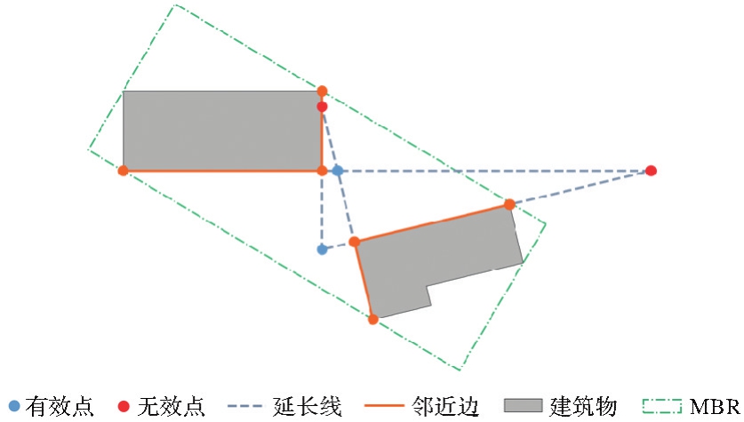
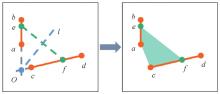
图11
角平分线约束下的桥接面生成"
图12
错位型建筑物合并"
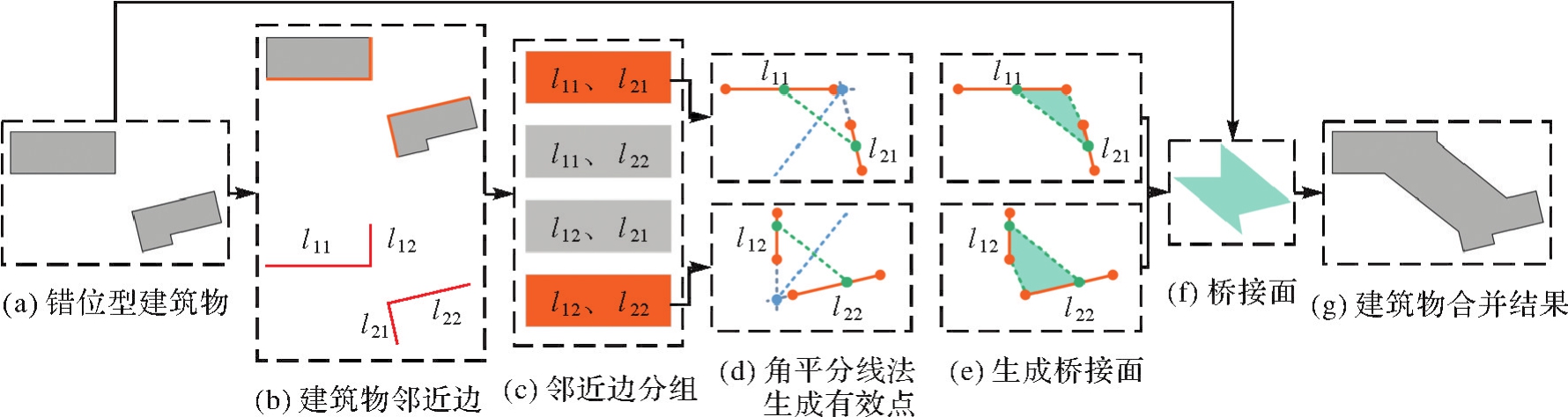
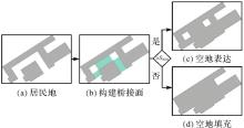
图13
建筑物空地表达与填充"

图14
建筑物合并流程"
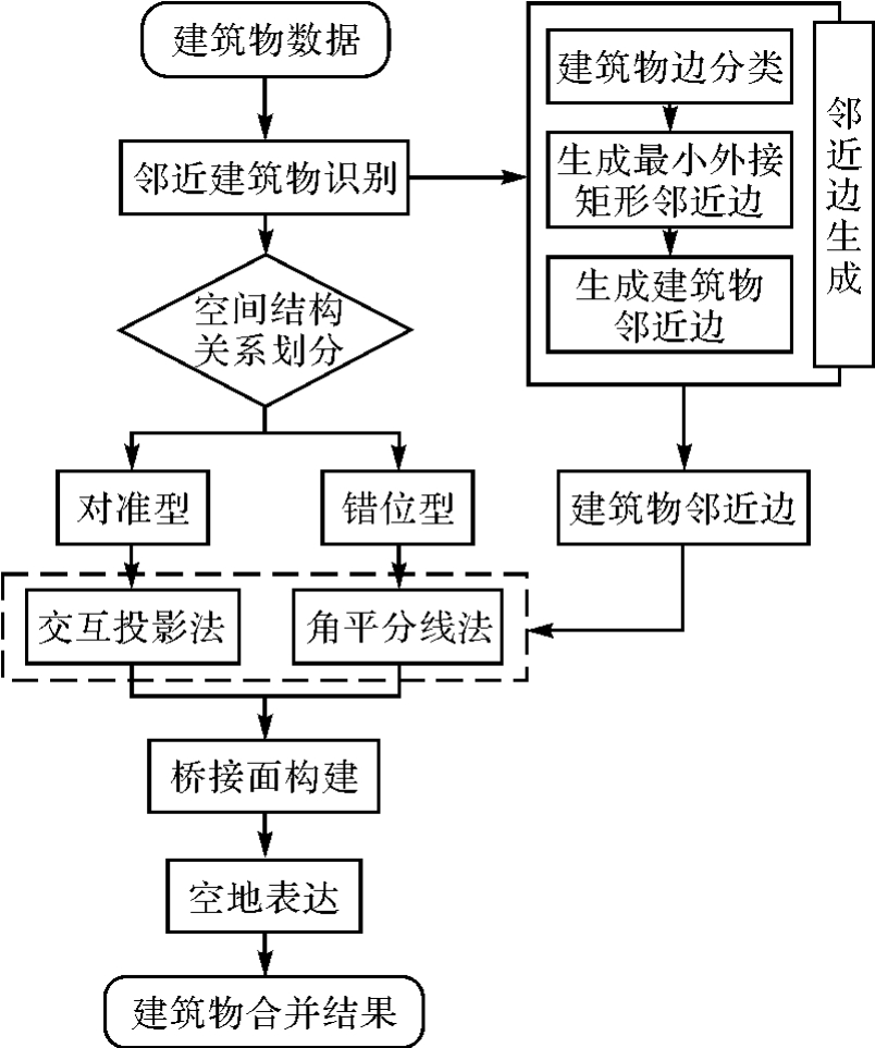
图15
典型建筑物合并(非依比例尺显示)"
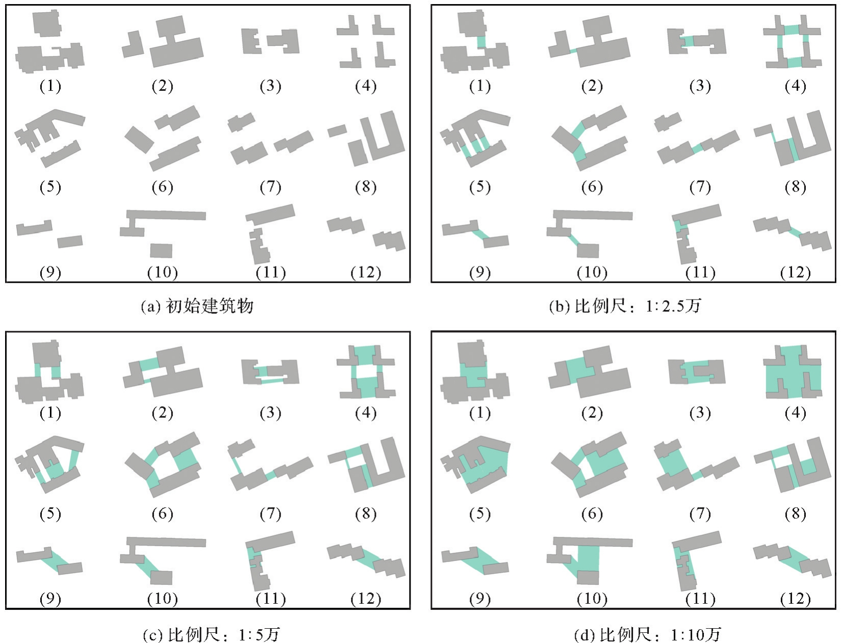
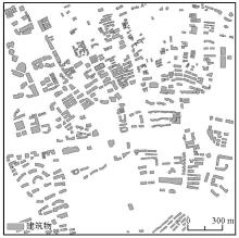
图16
试验数据2"
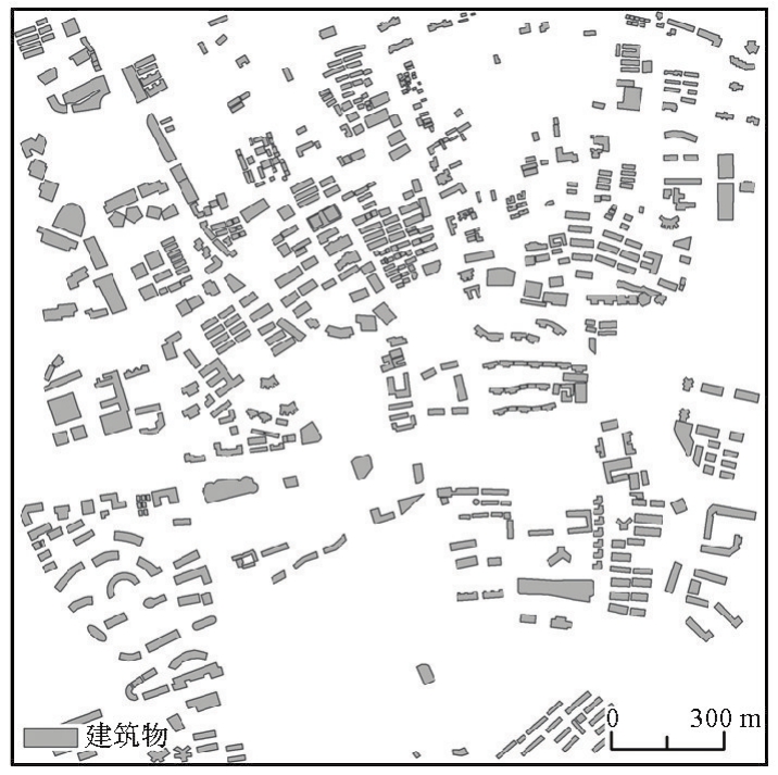
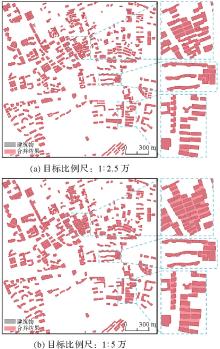
图17
群组建筑物合并"
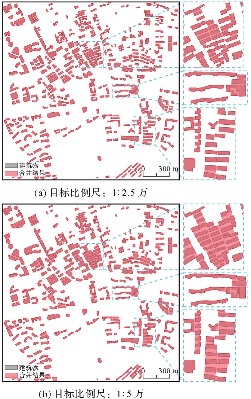
表3
群组建筑物合并试验指标"
| 试验 | 建筑物数量 | 目标比例尺 | 总面积/m2 | 直角占比/(%) | 建筑物数量变化率/(%) | 建筑物面积变化率/(%) |
|---|---|---|---|---|---|---|
| 试验1 | 327 | 1∶2.5万 | 565 825.72 | 75.44 | -50.00 | 7.41 |
| 试验2 | 177 | 1∶5万 | 663 545.11 | 68.59 | -72.94 | 25.96 |
表4
各合并结果评估参数对比"
| 试验方法 | 建筑物数量 | 建筑物面积/m2 | 建筑物直角占比/(%) | 建筑物数量变化率/(%) | 建筑物面积变化率/(%) |
|---|---|---|---|---|---|
| 本文方法 | 45 | 255 539.68 | 84.12 | -81.14 | 39.03 |
| Arc Map方法 | 82 | 247 399.73 | 82.31 | -64.04 | 34.60 |
| 文献[ | 53 | 250 345.93 | 77.39 | -76.75 | 36.20 |
| 文献[ | 54 | 247 482.89 | 81.49 | -76.32 | 34.65 |
| 文献[ | 65 | 252 183.39 | 81.17 | -71.49 | 37.20 |
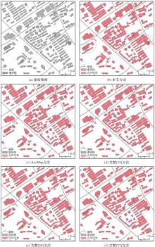
图18
合并结果的对比试验"

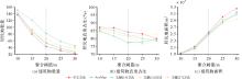
图19
各指标变化"

| [1] | 刘先林. 为社会进步服务的测绘高新技术[J]. 测绘科学, 2019, 44(6): 1-15. |
| LIU Xianlin. High technologies of surveying and mapping for social progress[J]. Science of Surveying and Mapping, 2019, 44(6): 1-15. | |
| [2] |
胡慧明, 钱海忠, 何海威, 等. 采用层次分析法的面状居民地自动选取[J]. 测绘学报, 2016, 45(6): 740-746,755. DOI:.
doi: 10.11947/j.AGCS.2016.20150078 |
|
HU Huiming, QIAN Haizhong, HE Haiwei, et al. Auto-selection of areal habitation based on analytic hierarchy process[J]. Acta Geodaetica et Cartographica Sinica, 2016, 45(6): 740-746,755. DOI:.
doi: 10.11947/j.AGCS.2016.20150078 |
|
| [3] | 王家耀. 地图集:重构复杂非线性地理世界的“百科全书”[J]. 测绘地理信息, 2021, 46(1): 1-8. |
| WANG Jiayao. Atlas: the “Encyclopedia” of reconstructing complex nonlinear geographical world[J]. Journal of Geomatics, 2021, 46(1): 1-8. | |
| [4] |
尹烁, 闫小明, 晏雄锋. 基于特征边重构的建筑物化简方法[J]. 测绘学报, 2020, 49(6): 703-710. DOI:.
doi: 10.11947/j.AGCS.2020.20190299 |
|
YIN Shuo, YAN Xiaoming, YAN Xiongfeng. Simplification method of building polygon based on feature edges reconstruction[J]. Acta Geodaetica et Cartographica Sinica, 2020, 49(6): 703-710. DOI:.
doi: 10.11947/j.AGCS.2020.20190299 |
|
| [5] | 唐曾杨, 艾廷华, 徐海江. 地理知识图谱下的建筑群空间分布模式推理[J]. 地球信息科学学报, 2023, 25(6): 1202-1214. |
| TANG Zengyang, AI Tinghua, XU Haijiang. Reasoning of spatial distribution pattern of building cluster based on geographic knowledge graph[J]. Journal of Geo-Information Science, 2023, 25(6): 1202-1214. | |
| [6] |
魏智威, 肖屹, 童莹, 等. 基于知识图谱的直线型建筑物模式识别方法[J]. 测绘学报, 2023, 52(8): 1355-1363. DOI:.
doi: 10.11947/j.AGCS.2023.20220121 |
|
WEI Zhiwei, XIAO Yi, TONG Ying, et al. Linear building pattern recognition via spatial knowledge graph[J]. Acta Geodaetica et Cartographica Sinica, 2023, 52(8): 1355-1363. DOI:.
doi: 10.11947/j.AGCS.2023.20220121 |
|
| [7] | 朵天林. 居民地综合决策模型和方法研究[D]. 郑州: 信息工程大学, 2020. |
| DUO Tianlin. Research on decision model and method of cartographic generalization of residential areas[D]. Zhengzhou: Information Engineering University, 2020. | |
| [8] | DU S, LUO L, CAO K, et al. Extracting building patterns with multilevel graph partition and building grouping[J]. ISPRS Journal of Photogrammetry and Remote Sensing, 2016, 122: 81-96. |
| [9] | YAN X, AI T, YANG M, et al. A graph convolutional neural network for classification of building patterns using spatial vector data[J]. ISPRS Journal of Photogrammetry and Remote Sensing, 2019, 150: 259-273. |
| [10] | WANG X, BURGHARDT D. A typification method for linear building groups based on stroke simplification[J]. Geocarto International, 2021, 36(15): 1732-1751. |
| [11] |
行瑞星, 武芳, 巩现勇, 等. 建筑群组合直线模式识别的模板匹配方法[J]. 测绘学报, 2021, 50(6): 800-811. DOI:.
doi: 10.11947/j.AGCS.2021.20200298 |
|
XING Ruixing, WU Fang, GONG Xianyong, et al. The template matching approach to combined collinear pattern recognition in building groups[J]. Acta Geodaetica et Cartographica Sinica, 2021, 50(6): 800-811. DOI:.
doi: 10.11947/j.AGCS.2021.20200298 |
|
| [12] | HE X, ZHANG X, XIN Q. Recognition of building group patterns in topographic maps based on graph partitioning and random forest[J]. ISPRS Journal of Photogrammetry and Remote Sensing, 2018, 136: 26-40. |
| [13] | WANG H, XU Y, HU A, et al. Building pattern recognition by using an edge-attention multi-head graph convolutional network[J]. International Journal of Geographical Information Science, 2018(32): 1-26. |
| [14] | WEI Z, XU W, XIAO Y, et al. Enhancing building pattern recognition through multi-scale data and knowledge graph: a case study of C-shaped patterns[J]. International Journal of Digital Earth, 2023, 16(1): 3860-3881. |
| [15] | 王光霞, 杨培. 数学形态学在居民地街区合并中的应用[J]. 测绘学院学报, 2000(3): 201-203,206. |
| WANG Guangxia, YANG Pei. Application of mathematic morphology in uniting blocks of residential area[J]. Journal of Institute of Surveying and Mapping, 2000(3): 201-203,206. | |
| [16] | 郭仁忠, 艾廷华. 制图综合中建筑物多边形的合并与化简[J]. 武汉测绘科技大学学报, 2000(1): 25-30. |
| GUO Renzhong, AI Tinghua. Simplification and aggregation of building polygon in automatic map generalization[J]. Journal of Wuhan Technical University of Surveying and Mapping, 2000(1): 25-30. | |
| [17] | SHEN Y, AI T, LI W, et al. A polygon aggregation method with global feature preservation using superpixel segmentation[J]. Computers, Environment and Urban Systems, 2019, 75: 117-131. |
| [18] | SESTER M, FENG Y, THIEMANN F. Building generalization using deep learning[J]. ISPRS-International Archives of the Photogrammetry, Remote Sensing and Spatial Information Sciences, 2018, XLII-4: 565-572. |
| [19] | 李安平, 翟仁健, 殷吉崇, 等. 顾及空间结构关系的居民地自动合并方法[J]. 武汉大学学报(信息科学版), 2024, 49(9): 1723-1733. |
| LI Anping, ZHAI Renjian, YIN Jichong, et al. Automatic aggregation of building considering the spatial structure[J]. Geomatics and Information Science of Wuhan University, 2024, 49(9): 1723-1733. | |
| [20] | PENG D, TOUYA G. Continuously generalizing buildings to built-up areas by aggregating and growing[C]//Proceedings of the 3rd ACM SIGSPATIAL Workshop on Smart Cities and Urban Analytics. Redondo Beach: ACM Press, 2017: 1-8. |
| [21] |
王勇, 罗安, 王慧慧, 等. 复杂建筑物最短邻近线多边形聚合法[J]. 测绘学报, 2021, 50(12): 1671-1682. DOI:.
doi: 10.11947/j.AGCS.2021.20200493 |
|
WANG Yong, LUO An, WANG Huihui, et al. A method of polygon aggregation for complex buildings based on shortest adjacent lines[J]. Acta Geodaetica et Cartographica Sinica, 2021, 50(12): 1671-1682. DOI:.
doi: 10.11947/j.AGCS.2021.20200493 |
|
| [22] |
陈占龙, 鲁谢春, 徐永洋. 基于图顶点深度聚类的建筑物合并方法[J]. 测绘学报, 2024, 53(4): 736-749. DOI:.
doi: 10.11947/j.AGCS.2024.20230316 |
|
CHEN Zhanlong, LU Xiechun, XU Yongyang. A building aggregation method based on deep clustering of graph vertices[J]. Acta Geodaetica et Cartographica Sinica, 2024, 53(4): 736-749. DOI:.
doi: 10.11947/j.AGCS.2024.20230316 |
|
| [23] | AI T, YIN H, SHEN Y, et al. A formal model of neighborhood representation and applications in urban building aggregation supported by Delaunay triangulation[J]. PLOS ONE, 2019, 14(7): e0218877. |
| [24] |
郭沛沛, 李成名, 殷勇. 建筑物合并的Delaunay三角网分类过滤法[J]. 测绘学报, 2016, 45(8): 1001-1007. DOI:.
doi: 10.11947/j.AGCS.2016.20150587 |
|
GUO Peipei, LI Chengming, YIN Yong. Classification and filtering of constrained delaunay triangulation for automated building aggregation[J]. Acta Geodaetica et Cartographica Sinica, 2016, 45(8): 1001-1007. DOI:.
doi: 10.11947/j.AGCS.2016.20150587 |
|
| [25] | 张巧凤. 应用Delaunay三角网进行城市居民地和路网自动综合理论和方法研究[D]. 太原: 太原理工大学, 2005. |
| ZHANG Qiaofeng. Study on the theory and method of automatic synthesis of urban residential land and road network by Delaunay triangulation[D]. Taiyuan: Taiyuan University of Technology, 2005. | |
| [26] | USUI H, TERAKI A, OKUNUKI KI, et al. A comparison of neighbourhood relations based on ordinary Delaunay diagrams and area Delaunay diagrams: an application to define the neighbourhood relations of buildings[J]. International Journal of Geographical Information Science, 2020, 34(11): 2177-2203. |
| [27] | ZHANG F, SUN Q, MA J, et al. A polygonal buildings aggregation method considering obstacle elements and visual clarity[J]. Geocarto International, 2023, 38(1): 2266672. |
| [28] | REGNAULD N. Algorithms for the amalgamation of topographic data[C]//Proceedings of the 21st International Cartographic Conference. Durban: [s.n.], 2003. |
| [29] | HE X, ZHANG X, YANG J. Progressive amalgamation of building clusters for map generalization based on scaling subgroups[J]. ISPRS International Journal of Geo-Information, 2018, 7(3): 116. |
| [30] | WANG L, ZHANG J, YAO G. The analysis and experiments of least-squares method for settlements generalization[C]//Proceedings of 2012 IEEE International Conference on Information Science and Technology. Wuhan: IEEE, 2012: 210-214. |
| [31] | 苏友能, 徐青, 朱新铭, 等. POI点要素空间邻近图质量评价——以Delaunay三角网和缓冲区构建方法为例[J]. 地理与地理信息科学, 2024, 40(3): 14-20. |
| SU Youneng, XU Qing, ZHU Xinming, et al. Quality evaluation on spatial proximity graph of POI based on Delaunay triangulation network and buffer construction method[J]. Geography and Geo-Information Science, 2024, 40(3): 14-20. | |
| [32] |
巩现勇, 武芳. 城市建筑群网格模式的图论识别方法[J]. 测绘学报, 2014, 43(9): 960-968. DOI:.
doi: 10.13485/j.cnki.11-2089.2014.0125 |
|
GONG Xianyong, WU Fang. The graph theory approach to grid pattern recognition in urban building groups[J]. Acta Geodaetica et Cartographica Sinica, 2014, 43(9): 960-968. DOI:.
doi: 10.13485/j.cnki.11-2089.2014.0125 |
|
| [33] |
肖天元, 艾廷华, 余华飞, 等. 地图综合图卷积神经网络点群简化方法[J]. 测绘学报, 2024, 53(1): 158-172. DOI:.
doi: 10.11947/j.AGCS.2024.20220584 |
|
XIAO Tianyuan, AI Tinghua, YU Huafei, et al. A point cluster simplification approach of graph convolutional neural network for map generalization[J]. Acta Geodaetica et Cartographica Sinica, 2024, 53(1): 158-172. DOI:.
doi: 10.11947/j.AGCS.2024.20220584 |
|
| [34] | 全国地理信息标准化技术委员会. 国家基本比例尺地图图式 第3部分:1∶25 000 1∶50 000 1∶100 000地形图图式:GB/T 20257.3—2017[S]. 北京: 中国标准出版社, 2017. |
| National Technical Committee for Geographic Information Standardization. Cartographic symbols for national fundamental scale maps: part 3: specifications for cartographic symbols 1∶25 000 1∶50 000 & 1∶100 000 topographic maps: GB/T 20257.3—2017[S]. Beijing: Standards Press of China, 2017. | |
| [35] | 张秀红, 陈迪, 刘纪平, 等. 结构化居民地群的多层次识别方法[J]. 武汉大学学报(信息科学版), 2018, 43(8): 1144-1151. |
| ZHANG Xiuhong, CHEN Di, LIU Jiping, et al. A multilevel identification approach to structured building clusters[J]. Geomatics and Information Science of Wuhan University, 2018, 43(8): 1144-1151. |
| [1] | 贺彪, 林浩嘉, 郭仁忠, 蒯希, 马丁, 张琛. 基于视觉感知的三维空间相似关系量化计算[J]. 测绘学报, 2026, 55(1): 138-153. |
| [2] | 孟妮娜, 李凤梅, 周校东. 数据与认知双驱动的建筑物群制图综合结果与尺度一致性识别[J]. 测绘学报, 2025, 54(7): 1318-1331. |
| [3] | 林浩嘉, 郭仁忠, 贺彪, 蒯希, 马丁, 李程鹏. 视觉感知导向的实景三维建筑场景LOD自适应可视化[J]. 测绘学报, 2025, 54(6): 1054-1070. |
| [4] | 陈占龙, 鲁谢春, 徐永洋. 基于图顶点深度聚类的建筑物合并方法[J]. 测绘学报, 2024, 53(4): 736-749. |
| [5] | 罗飘, 许俊奎, 武芳, 吕亚坤, 庄清文. 一种生成式神经网络的道路简化方法[J]. 测绘学报, 2024, 53(10): 2007-2020. |
| [6] | 王安东, 武芳, 巩现勇, 翟仁健, 刘呈熠, 邱越, 张寒雪. 一种城市路网多层次复合网格模式识别方法[J]. 测绘学报, 2023, 52(11): 1994-2006. |
| [7] | 艾廷华, 张翔. 地理信息科学中尺度概念的诠释与表达[J]. 测绘学报, 2022, 51(7): 1640-1652. |
| [8] | 于洋洋, 贺康杰, 武芳, 许俊奎. 面状居民地形状分类的图卷积神经网络方法[J]. 测绘学报, 2022, 51(11): 2390-2402. |
| [9] | 行瑞星, 武芳, 巩现勇, 杜佳威, 刘呈熠. 建筑群组合直线模式识别的模板匹配方法[J]. 测绘学报, 2021, 50(6): 800-811. |
| [10] | 刘鹏程, 肖天元, 肖佳, 艾廷华. 曲线多尺度表达的Head-Tail信息量分割法[J]. 测绘学报, 2020, 49(7): 921-933. |
| [11] | 刘呈熠, 武芳, 巩现勇, 行瑞星, 罗登瀚. 规则池塘群的复杂直线模式识别[J]. 测绘学报, 2020, 49(2): 256-266. |
| [12] | 程绵绵, 孙群, 徐立, 陈换新. 面轮廓线相似性和复杂性度量及在化简中的应用[J]. 测绘学报, 2019, 48(4): 489-501. |
| [13] | 张立华, 唐露露, 贾帅东, 戴泽源. 多条海岸线协同化简的层次化三角网分区法[J]. 测绘学报, 2019, 48(4): 520-531. |
| [14] | 李成名, 殷勇, 吴伟, 武鹏达. Stroke特征约束的树状河系层次关系构建及简化方法[J]. 测绘学报, 2018, 47(4): 537-546. |
| [15] | 杜佳威, 武芳, 李靖涵, 行瑞星, 巩现勇. 一种河口湾海岸线渐进化简方法[J]. 测绘学报, 2018, 47(4): 547-556. |
| 阅读次数 | ||||||
|
全文 |
|
|||||
|
摘要 |
|
|||||