


测绘学报 ›› 2025, Vol. 54 ›› Issue (4): 725-735.doi: 10.11947/j.AGCS.2025.20240360
杨文涛1( ), 郭斐1(), 张小红1,2, 张治宇1, 朱逸凡1, 李政1, 吴子恒1
收稿日期:2024-09-02
出版日期:2025-05-30
发布日期:2025-05-30
通讯作者:
郭斐
E-mail:yangwentao@whu.edu.cn;fguo@whu.edu.cn
作者简介:杨文涛(1997—),男,博士生,研究方向为GNSS反射测量。 E-mail:yangwentao@whu.edu.cn
基金资助:
Wentao YANG1(), Fei GUO1(), Xiaohong ZHANG1,2, Zhiyu ZHANG1, Yifan ZHU1, Zheng LI1, Ziheng WU1
Received:2024-09-02
Online:2025-05-30
Published:2025-05-30
Contact:
Fei GUO
E-mail:yangwentao@whu.edu.cn;fguo@whu.edu.cn
About author:YANG Wentao (1997—), male, PhD candidate, majors in GNSS reflectometry. E-mail: yangwentao@whu.edu.cn
Supported by:摘要:
全球导航卫星系统反射测量(GNSS-R)技术已被应用于监测土壤湿度(SM)和冻融(F/T)状态。然而,目前GNSS-R SM反演结果在高海拔地区尚属空白,GNSS-R F/T反演结果也仅有短时间序列。因此,本文利用Cyclone GNSS(CYGNSS)数据建立了青藏高原地区为期5年的GNSS-R SM和F/T记录。与SMAP参考值相比,CYGNSS SM的均方根误差(RMSE)和相关性(R)分别为0.064 cm3/cm3和0.53。CYGNSS F/T的分类准确率为85.5%。独立地面观测站的验证结果显示,CYGNSS SM的RMSE和R分别为0.059 cm3/cm3和0.56,CYGNSS F/T的分类准确率为83.8%,与同期SMAP的SM和F/T分类准确率相当。这项研究将提供高海拔地区长时间序列的GNSS-R SM和F/T记录。值得注意的是,CYGNSS的可用天数明显多于SMAP。CYGNSS SM的可用天数比SMAP SM高47.0%,CYGNSS F/T的可用天数比SMAP F/T高14.7%。此外,本文为CYGNSS和SMAP开发了一个经验融合框架。融合后的CYGNSS和SMAP SM(即CYGNSS-SMAP SM)的平均RMSE为0.056 cm3/cm3,R为0.60。与现有的SMAP SM相比,精度提高了18.8%,可用天数增加了34.7%。融合CYGNSS和SMAP F/T(即CYGNSS-SMAP F/T)的精度为89.8%。与现有的SMAP F/T相比,精度提高了10.0%,可用天数增加了10.2%。融合CYGNSS反射计和SMAP辐射计观测数据可在青藏高原地区提供更高精度和连续性的SM和F/T。本文也证明了星载GNSS-R技术在高海拔地区具有强大的监测能力。
中图分类号:
杨文涛, 郭斐, 张小红, 张治宇, 朱逸凡, 李政, 吴子恒. 利用GNSS反射计和SMAP辐射计反演青藏高原土壤湿度和冻融状态[J]. 测绘学报, 2025, 54(4): 725-735.
Wentao YANG, Fei GUO, Xiaohong ZHANG, Zhiyu ZHANG, Yifan ZHU, Zheng LI, Ziheng WU. Soil moisture and freeze-thaw map using GNSS reflectometer and SMAP radiometer for Qinghai-Xizang Plateau[J]. Acta Geodaetica et Cartographica Sinica, 2025, 54(4): 725-735.
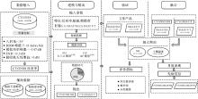
图1
星载GNSS-R SM与F/T反演、验证及与SMAP融合流程"

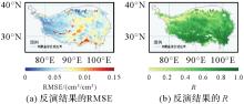
图2
CYGNSS SM在青藏高原地区的反演性能(反演期为2018年1月1日至2022年12月31日)"

图3
不同时期每日CYGNSS SM和SMAP SM的空间分布"
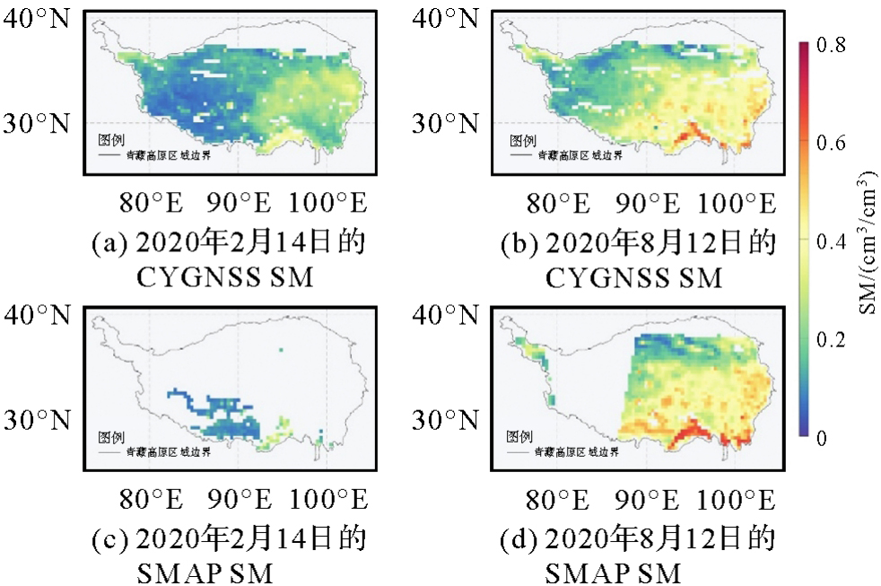

图4
不同时期CYGNSS SM和SMAP SM月平均值的空间分布"
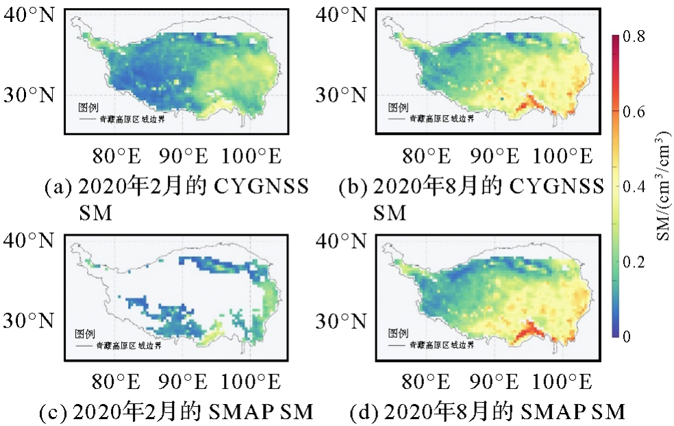
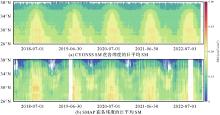
图5
霍夫莫勒图"
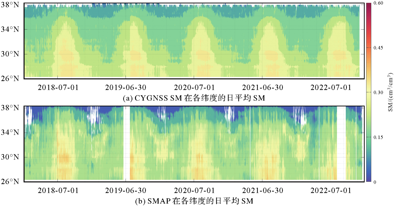
图6
CYGNSS F/T分类精度的逐网格空间分布"
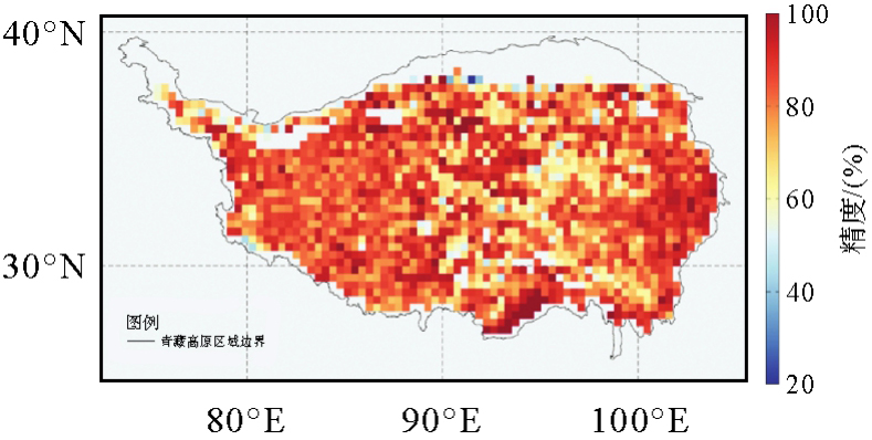

图7
不同时期CYGNSS F/T和SMAP F/T的每日空间分布"
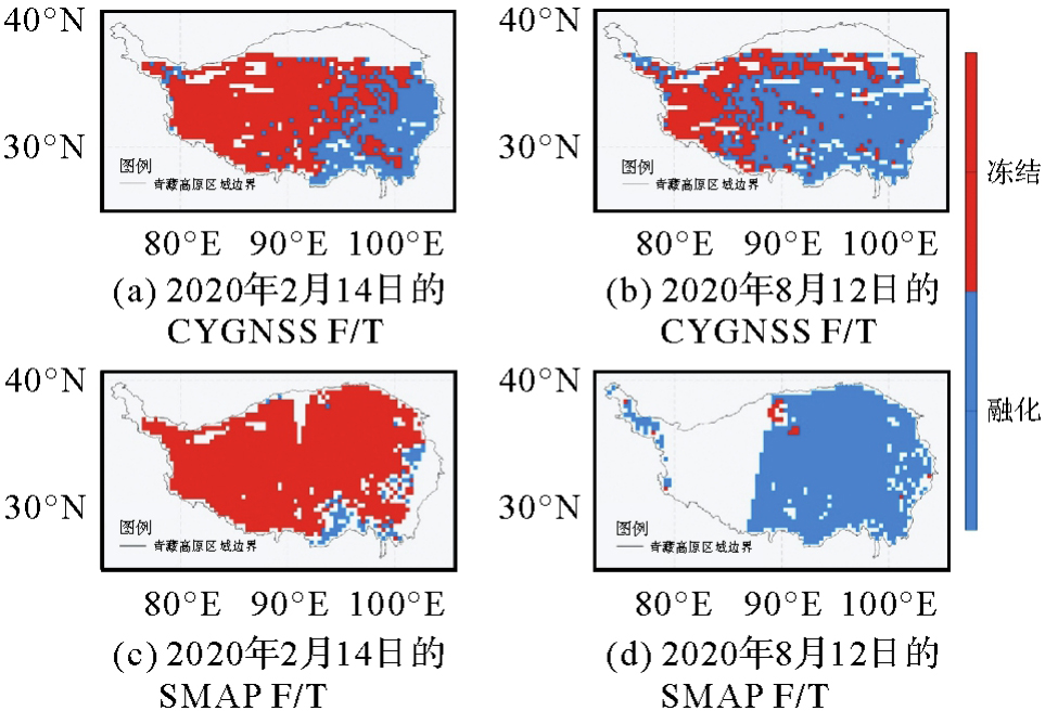

图8
用于现场验证的ISMN站点分布"
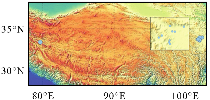
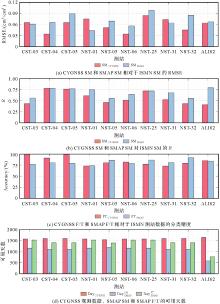
图9
CYGNSS SM与SMAP SM相对于原始站的表现统计结果"

表1
来自CYGNSS和SMAP的SM和F/T结果与所选原位数据的比较"
| 测站 | 网络 | 纬度 | 经度 | SMCYGNSS | F/TCYGNSS | SMSMAP | F/TSMAP | |||||
|---|---|---|---|---|---|---|---|---|---|---|---|---|
| R | RMSE/(cm3/cm3) | 分类精度/(%) | 天数 | R | RMSE/(cm3/cm3) | 天数 | 分类精度/(%) | 天数 | ||||
| CST-03 | MAQU | 33.9°N | 102.0°E | 0.43 | 0.065 | 100 | 1573 | 0.56 | 0.061 | 1155 | 76.7 | 1523 |
| CST-04 | MAQU | 33.8°N | 101.7°E | 0.78 | 0.034 | 90.8 | 1593 | 0.78 | 0.065 | 1094 | 80.1 | 1401 |
| CST-05 | MAQU | 33.7°N | 101.9°E | 0.76 | 0.065 | 98.7 | 1593 | 0.77 | 0.089 | 1094 | 78.8 | 1401 |
| NST-01 | MAQU | 33.9°N | 102.1°E | 0.61 | 0.075 | 73.0 | 1573 | 0.75 | 0.043 | 1155 | 73.5 | 1523 |
| NST-05 | MAQU | 33.6°N | 102.0°E | 0.46 | 0.051 | 80.2 | 1536 | 0.55 | 0.069 | 1197 | 85.9 | 1392 |
| NST-06 | MAQU | 34.0°N | 102.3°E | 0.51 | 0.034 | 81.8 | 1573 | 0.64 | 0.056 | 1155 | 78.5 | 1523 |
| NST-25 | MAQU | 34.0°N | 102.0°E | 0.72 | 0.084 | 77.0 | 1573 | 0.72 | 0.098 | 1155 | 86.4 | 1523 |
| NST-31 | MAQU | 33.7°N | 101.9°E | 0.52 | 0.073 | 72.9 | 1593 | 0.68 | 0.064 | 1094 | 80.8 | 1401 |
| NST-32 | MAQU | 33.7°N | 101.8°E | 0.43 | 0.045 | 79.0 | 1593 | 0.55 | 0.085 | 1094 | 91.5 | 1401 |
| ALI02 | NGARI | 33.5°N | 79.6°E | 0.41 | 0.064 | 84.9 | 1647 | 0.79 | 0.067 | 586 | 83.9 | 773 |
| All | 0.56 | 0.059 | 83.8 | 1585 | 0.68 | 0.069 | 1078 | 81.6 | 1386 | |||

图10
CYGNSS SM相较于SMAP SM的观测提升统计结果"
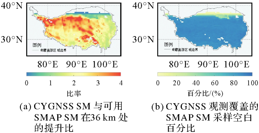
图11
CYGNSS F/T相较于SMAP F/T的观测提升统计结果"
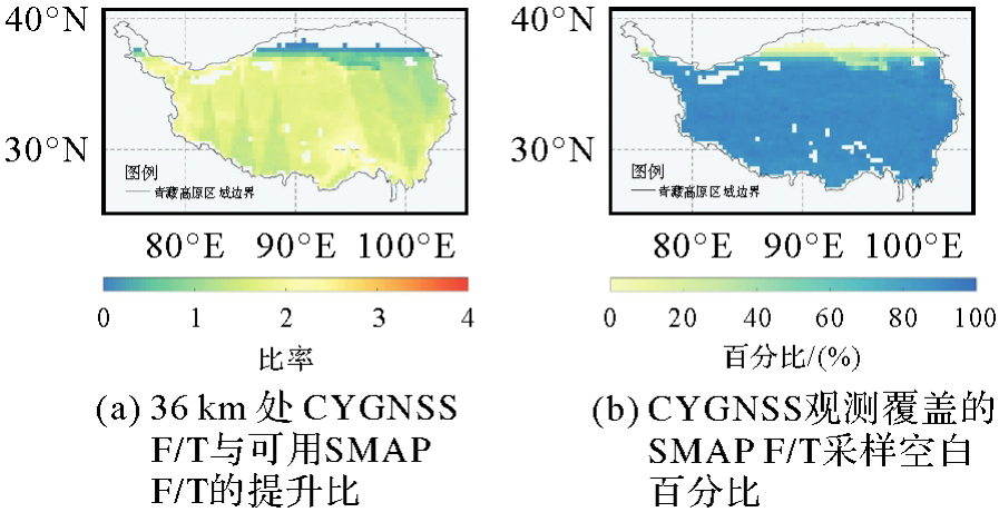
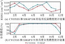
图12
CYGNSS和SMAP在反演周期内的月度性能信息"
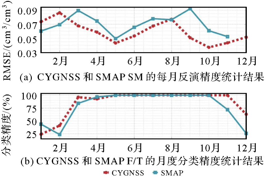
表2
融合CYGNSS和SMAP的SM和F/T结果的性能"
| 测站 | 网络 | 纬度 | 经度 | CYGNSS-SMAP SM | CYGNSS-SMAP F/T | |||
|---|---|---|---|---|---|---|---|---|
| R | RMSE/(cm3/cm3) | 天数 | 分类精度/(%) | 天数 | ||||
| CST-03 | MAQU | 33.9°N | 102.0°E | 0.70 | 0.058 | 1447 | 95.3 | 1578 |
| CST-04 | MAQU | 33.8°N | 101.7°E | 0.70 | 0.039 | 1460 | 84.5 | 1584 |
| CST-05 | MAQU | 33.7°N | 101.9°E | 0.70 | 0.062 | 1460 | 83.9 | 1584 |
| NST-01 | MAQU | 33.9°N | 102.1°E | 0.61 | 0.070 | 1447 | 83.8 | 1578 |
| NST-05 | MAQU | 33.6°N | 102.0°E | 0.74 | 0.049 | 1424 | 93.0 | 1524 |
| NST-06 | MAQU | 34.0°N | 102.3°E | 0.66 | 0.038 | 1447 | 92.5 | 1578 |
| NST-25 | MAQU | 34.0°N | 102.0°E | 0.57 | 0.076 | 1447 | 90.0 | 1578 |
| NST-31 | MAQU | 33.7°N | 101.9°E | 0.59 | 0.038 | 1460 | 85.4 | 1584 |
| NST-32 | MAQU | 33.7°N | 101.8°E | 0.31 | 0.060 | 1460 | 94.8 | 1584 |
| ALI02 | NGARI | 33.5°N | 79.6°E | 0.40 | 0.065 | 1468 | 94.7 | 1569 |
| All | 0.60 | 0.056 | 1452 | 89.8 | 1574 | |||
| [1] | WALKER J P, WILLGOOSE G R, KALMA J D. In situ measurement of soil moisture: a comparison of techniques[J]. Journal of Hydrology, 2004, 293(1-4): 85-99. |
| [2] | ROWLANDSON T L, BERG A A, ROY A, et al. Capturing agricultural soil freeze/thaw state through remote sensing and ground observations: a soil freeze/thaw validation campaign[J]. Remote Sensing of Environment, 2018, 211: 59-70. |
| [3] | JIANG Hongtao, SHEN Huanfeng, LI Xinghua, et al. Extending the SMAP 9-km soil moisture product using a spatio-temporal fusion model[J]. Remote Sensing of Environment, 2019, 231: 111224. |
| [4] | ZHANG T, ARMSTRONG R L, SMITH J. Investigation of the near-surface soil freeze-thaw cycle in the contiguous United States: algorithm development and validation[J]. Journal of Geophysical Research: Atmospheres, 2003, 108(D22): 8860. |
| [5] | CHAPARRO D, PILES M, VALL-LLOSSERA M, et al. L-band vegetation optical depth seasonal metrics for crop yield assessment[J]. Remote Sensing of Environment, 2018, 212: 249-259. |
| [6] | LU Hui, ZHENG Donghai, YANG Kun, et al. Last-decade progress in understanding and modeling the land surface processes on the Xizang Plateau[J]. Hydrology and Earth System Sciences, 2020, 24(12): 5745-5758. |
| [7] | ROYDEN L H, BURCHFIEL B C, VAN DER HILST R D. The geological evolution of the Xizang Plateau[J]. Science, 2008, 321(5892): 1054-1058. |
| [8] | KOU Xiaokang, JIANG Lingmei, YAN Shuang, et al. Detection of land surface freeze-thaw status on the Xizang Plateau using passive microwave and thermal infrared remote sensing data[J]. Remote Sensing of Environment, 2017, 199: 291-301. |
| [9] | 李黄, 夏青, 尹聪, 等. 我国GNSS-R遥感技术的研究现状与未来发展趋势[J]. 雷达学报, 2013(4): 389-399. |
| LI Huang, XIA Qing, YIN Cong, et al. Research status and future development trend of GNSS-R remote sensing technology in China[J]. Journal of Radars, 2013(4): 389-399. | |
| [10] | LI Bowen, YANG Dongkai, ZHANG Bo. Simulation of multi-satellite GNSS reflected signals and design of simulator[J]. Journal of Geodesy and Geoinformation Science, 2021, 4(2): 36-46. |
| [11] | CAMPS A, PARK H, PABLOS M, et al. Sensitivity of GNSS-R spaceborne observations to soil moisture and vegetation[J]. IEEE Journal of Selected Topics in Applied Earth Observations and Remote Sensing, 2016, 9(10): 4730-4742. |
| [12] | LI Zheng, GUO Fei, CHEN Fade, et al. Wind speed retrieval using GNSS-R technique with geographic partitioning[J]. Satellite Navigation, 2023, 4(1): 4. |
| [13] | JIN Shuanggen, CAMPS A, JIA Yan, et al. Remote sensing and its applications using GNSS reflected signals: advances and prospects[J]. Satellite Navigation, 2024, 5(1): 19. |
| [14] | ALONSO-ARROYO A, ZAVOROTNY V U, CAMPS A. Sea ice detection using U. K. TDS-1 GNSS-R data[J]. IEEE Transactions on Geoscience and Remote Sensing, 2017, 55(9): 4989-5001. |
| [15] | RUF C, UNWIN M, DICKINSON J, et al. CYGNSS: enabling the future of hurricane prediction remote sensing satellites[J]. IEEE Geoscience and Remote Sensing Magazine, 2013, 1(2): 52-67. |
| [16] | WAN W, LIU B, GUO Z, et al. Initialevaluation of the first Chinese GNSS-R mission BuFeng-1 A/B for soil moisture estimation[J]. IEEE Geoscience and Remote Sensing Letters, 2021, 19: 8017305. |
| [17] | JALES P, ESTERHUIZEN S, MASTERS D, et al. The new spire GNSS-R satellite missions and products[C]//Proceedings of 2020 Image and Signal Processing for Remote Sensing XXVI. London: SPIE, 2020: 41. |
| [18] | 王峰, 李建强, 杨东凯, 等. “吉林一号”宽幅01B卫星GNSS-R数据风速反演研究[J]. 武汉大学学报(信息科学版), 2024, 49(1): 56-67. |
| WANG Feng, LI Jiangiang, YANG Dongkai, et al. Wind speed retrieval using GNSS-R data from “Jilin-1” Kuanfu-01B satellite[J]. Geomatics and Information Science of Wuhan University, 2024, 49(1): 56-67. | |
| [19] | XIA Junming, BAI Weihua, SUN Yueqiang, et al. Calibration and wind speed retrieval for the Fengyun-3 E meteorological satellite GNSS-R mission[C]//Proceedings of 2021 IEEE Specialist Meeting on Reflectometry Using GNSS and Other Signals of Opportunity (GNSS+R). Beijing: IEEE, 2021: 25-28. |
| [20] | BU Jinwei, WANG Qiulan, WANG Ziyi, et al. Land remote sensing applications using spaceborne GNSS reflectometry: a comprehensive overview[J]. IEEE Journal of Selected Topics in Applied Earth Observations and Remote Sensing, 2024, 17: 12811-12841. |
| [21] | FU Naifeng, LI Fenghui. An introduction of GNSS reflectometer remote sensing mission from Yunyao aerospace technology Co., Ltd[C]//Proceedings of 2021 IEEE Specialist Meeting on Reflectometry Using GNSS and Other Signals of Opportunity (GNSS+R). Beijing: IEEE, 2021: 77-81. |
| [22] | ZHANG Yun, LU Qi, JIN Qin, et al. Global sea surface height measurement from CYGNSS based on machine learning[J]. IEEE Journal of Selected Topics in Applied Earth Observations and Remote Sensing, 2022, 16: 841-852. |
| [23] | CHEW C, SMALL E, HUELSING H. Flooding and inundation maps using interpolated CYGNSS reflectivity observations[J]. Remote Sensing of Environment, 2023, 293: 113598. |
| [24] | 张双成, 郭沁雨, 马中民, 等. 星载GNSS-R反演土壤湿度研究进展与思考[J]. 武汉大学学报(信息科学版), 2024, 49(1): 15-26. |
| ZHANG Shuangcheng, GUO Qinyu, MA Zhongmin, et al. Research advances and some thoughts on soil moisture retrieval by space-borne GNSS-R[J]. Geomatics and Information Science of Wuhan University, 2024, 49(1): 15-26. | |
| [25] | 严清赟, 王戴乐. CYGNSS信号对降水的时空响应及其驱动因子分析[J]. 武汉大学学报(信息科学版), 2024, 49(1): 109-121. |
| YAN Qingyun, WANG Daile. Spatiotemporal response of CYGNSS signals to precipitation and analysis of driving factors[J]. Geomatics and Information Science of Wuhan University, 2024, 49(1): 109-121. | |
| [26] |
布金伟. 星载GNSS-R技术反演海面降雨强度及风速和浪高方法研究[J]. 测绘学报, 2023, 52(9): 1616. DOI:.
doi: 10.11947/j.AGCS.2023.20220709 |
|
BU Jinwei. Study on retrieving sea surface rainfall intensity, wind speed and wave height using spaceborne GNSS-R technology[J]. Acta Geodaetica et Cartographica Sinica, 2023, 52(9): 1616. DOI:.
doi: 10.11947/j.AGCS.2023.20220709 |
|
| [27] | CHEW C C, SMALL E E. Soil moisture sensing using spaceborne GNSS reflections: comparison of CYGNSS reflectivity to SMAP soil moisture[J]. Geophysical Research Letters, 2018, 45(9): 4049-4057. |
| [28] | CHEW C, SMALL E. Description of the UCAR/CU soil moisture product[J]. Remote Sensing, 2020, 12(10): 1558. |
| [29] | 郭斐, 董桂芳, 朱逸凡, 等. 一种土地类型标签精细化的GNSS-R土壤湿度反演方法[J]. 武汉大学学报(信息科学版), 2024, 49(1): 47-55. |
| GUO Fei, DONG Guifang, ZHU Yifan, et al. A refined land type digitization method of GNSS-R soil moisture inversion[J]. Geomatics and Information Science of Wuhan University, 2024, 49(1): 47-55. | |
| [30] | YANG Wentao, GUO Fei, ZHANG Xiaohong, et al. An improved method for water body removal in spaceborne GNSS-R soil moisture retrieval[J]. IEEE Transactions on Geoscience and Remote Sensing, 2023, 61: 4701308. |
| [31] | ZHU Yifan, GUO Fei, ZHANG Xiaohong. Effect of surface temperature on soil moisture retrieval using CYGNSS[J]. International Journal of Applied Earth Observation and Geoinformation, 2022, 112: 102929. |
| [32] | CARRENO-LUENGO H, RUF C S. Retrieving freeze/thaw surface state from CYGNSS measurements[J]. IEEE Transactions on Geoscience and Remote Sensing, 2021, 60: 4302313. |
| [33] | WU Xuerui, DONG Zhounan, JIN Shuanggen, et al. First measurement of soil freeze/thaw cycles in the Xizang Plateau using CYGNSS GNSS-R data[J]. Remote Sensing, 2020, 12(15): 2361. |
| [34] | RUF C S, CHEW C, LANG T, et al. A new paradigm in earth environmental monitoring with the CYGNSS small satellite constellation[J]. Scientific Reports, 2018, 8(1): 8782. |
| [35] | CLARIZIA M P, RUF C S, GLEASON S, et al. Generation of CYGNSS level 2 wind speed data products[C]//Proceedings of 2017 IEEE International Geoscience and Remote Sensing Symposium. Fort Worth: IEEE, 2017: 2647-2649. |
| [36] | SAÏD F, JELENAK Z, PARK J, et al. The NOAA track-wise wind retrieval algorithm and product assessment for CyGNSS[J]. IEEE Transactions on Geoscience and Remote Sensing, 2021, 60: 4202524. |
| [37] | KIM H, LAKSHMI V. Use of cyclone global navigation satellite system (CYGNSS) observations for estimation of soil moisture[J]. Geophysical Research Letters, 2018, 45(16): 8272-8282. |
| [38] | DONG Zhounan, JIN Shuanggen. Evaluation of the land GNSS-reflected DDM coherence on soil moisture estimation from CYGNSS data[J]. Remote Sensing, 2021, 13(4): 570. |
| [39] | DE ROO R D, ULABY F T. Bistatic specular scattering from rough dielectric surfaces[J]. IEEE Transactions on Antennas and Propagation, 1994, 42(2): 220-231. |
| [40] | DOBSON M C, ULABY F T, HALLIKAINEN M T, et al. Microwave dielectric behavior of wet soil-part II: dielectric mixing models[J]. IEEE Transactions on Geoscience and Remote Sensing, 1985, GE-23(1): 35-46. |
| [41] | CHAN S K, BINDLISH R, O'NEILL P E, et al. Assessment of the SMAP passive soil moisture product[J]. IEEE Transactions on Geoscience and Remote Sensing, 2016, 54(8): 4994-5007. |
| [42] | LYU Haobo, MCCOLL K A, LI Xinlu, et al. Validation of the SMAP freeze/thaw product using categorical triple collocation[J]. Remote Sensing of Environment, 2018, 205: 329-337. |
| [43] | CLARIZIA M P, PIERDICCA N, COSTANTINI F, et al. Analysis of CYGNSS data for soil moisture retrieval[J]. IEEE Journal of Selected Topics in Applied Earth Observations and Remote Sensing, 2019, 12(7): 2227-2235. |
| [44] | YANG Wentao, GUO Fei, ZHANG Xiaohong, et al. Daily landscape freeze/thaw state detection using spaceborne GNSS-R data in Qinghai-Xizang Plateau[J]. IEEE Transactions on Geoscience and Remote Sensing, 2023, 61: 4302409. |
| [45] | HOVMÖLLER E. The trough-and-ridge diagram[J]. Tellus, 1949, 1(2): 62-66. |
| [46] | DORIGO W A, WAGNER W, HOHENSINN R, et al. The international soil moisture network: a data hosting facility for global in situ soil moisture measurements[J]. Hydrology and Earth System Sciences, 2011, 15(5): 1675-1698. |
| [1] | 曹云刚, 杨鹏, 龚江波, 朱高, 沈星宇. 空间关系增强与异构特征融合相结合的道路信息提取方法[J]. 测绘学报, 2025, 54(12): 2219-2232. |
| [2] | 马杜娟, 谢江流, 陈瑞, 严欣玉, 尹高飞. 青藏高原草地物候的空间尺度效应[J]. 测绘学报, 2024, 53(5): 860-868. |
| [3] | 杨梦娇, 赵伟, 詹琪琪, 张亚, 孟晓荣, 蔡俊飞, 杨羽佳. 基于偏相关分析的2003—2020年青藏高原地表温度变化驱动因子量化研究[J]. 测绘学报, 2024, 53(5): 848-859. |
| [4] | 周纪, 王子卫, 丁利荣, 唐文彬, 王伟, 马晋, 蒋蕙如, 刘双, 张涛, 侯映旭. 青藏高原冰冻圈温度遥感观测、反演与应用[J]. 测绘学报, 2024, 53(5): 835-847. |
| [5] | 韩潇然, 柯樱海, 于金媛, 赵孟杰, 张国庆. 基于SWOT卫星模拟数据的青藏高原湖泊水位与面积测量精度评估[J]. 测绘学报, 2024, 53(5): 823-834. |
| [6] | 郎丰铠, 何苏颖, 邱奥深, 时洪涛, 郑南山. 高砾石地表全极化SAR土壤水分反演方法[J]. 测绘学报, 2024, 53(11): 2189-2200. |
| [7] | 何佳星, 郑南山, 丁锐, 张克非, 陈天悦. 粒子群优化卷积神经网络GNSS-IR土壤湿度反演方法[J]. 测绘学报, 2023, 52(8): 1286-1297. |
| [8] | 陶庭叶, 李江洋, 朱勇超, 汪俊涛, 陈皓, 时梦杰. 阶段模型修正的星载GNSS-R土壤湿度反演方法[J]. 测绘学报, 2022, 51(9): 1942-1950. |
| [9] | 党亚民, 杨强, 王伟, 梁玉可. 基于块体模型的青藏高原及邻区地壳三维构造形变分析[J]. 测绘学报, 2022, 51(7): 1192-1205. |
| [10] | 汉牟田, 杨毅, 张波. GNSS信号土壤衰减模型的试验验证方法[J]. 测绘学报, 2020, 49(9): 1202-1212. |
| [11] | 梁月吉, 任超, 黄仪邦, 潘亚龙, 张志刚. 利用GPS-IR监测土壤湿度的多星线性回归反演模型[J]. 测绘学报, 2020, 49(7): 833-842. |
| [12] | 秦毅坤, 王泽根, 范东明. 青藏高原区域水储量变化的GRACE RL06和TRMM联合反演[J]. 测绘学报, 2020, 49(10): 1285-1294. |
| [13] | 邹文博, 张波, 洪学宝, 杨东凯, 崔兆韵. 利用北斗GEO卫星反射信号反演土壤湿度[J]. 测绘学报, 2016, 45(2): 199-204. |
| [14] | 汉牟田, 张波, 杨东凯, 洪学宝, 杨磊, 宋曙辉. 利用GNSS干涉信号振荡幅度反演土壤湿度[J]. 测绘学报, 2016, 45(11): 1293-1300. |
| [15] | 阚希, 张永宏, 曹庭, 王剑庚, 田伟. 利用多光谱卫星遥感和深度学习方法进行青藏高原积雪判识[J]. 测绘学报, 2016, 45(10): 1210-1221. |
| 阅读次数 | ||||||
|
全文 |
|
|||||
|
摘要 |
|
|||||