


测绘学报 ›› 2025, Vol. 54 ›› Issue (12): 2219-2232.doi: 10.11947/j.AGCS.2025.20250250
曹云刚( ), 杨鹏, 龚江波, 朱高, 沈星宇
收稿日期:2025-06-18
修回日期:2025-11-26
出版日期:2026-01-15
发布日期:2026-01-15
作者简介:曹云刚(1978—),男,博士,教授,研究方向为资源与环境遥感。 E-mail:yungang@swjtu.edu.cn
基金资助:
Yungang CAO(), Peng YANG, Jiangbo GONG, Gao ZHU, Xingyu SHEN
Received:2025-06-18
Revised:2025-11-26
Online:2026-01-15
Published:2026-01-15
About author:CAO Yungang (1978—), male, PhD, professor, majors in remote sensing of resources and environment. E-mail: yungang@swjtu.edu.cn
Supported by:摘要:
针对高原特殊环境下遥感影像中道路材质与背景混淆、结构细长易断裂等问题,本文提出了一种结合空间关系增强器(spatial relationship enhancer,SRE)和连通性约束损失(connectivity loss,Cnt_Loss)的改进道路提取模型SRENet。核心贡献包括:①设计空间关系增强器,通过关键点图卷积显式建模道路拓扑结构,显著提升弯曲与遮挡区域的连通性检测能力;②构建双分支架构并设计异构特征融合模块,实现语义特征与空间细节的互补增强,增强对材质与环境类似的低对比度道路的提取能力;③提出连通性约束损失函数,通过几何驱动优化抑制狭窄断裂区域的误分割。本文方法以双分支深度神经网络为基础,通过异构特征融合模块实现多尺度特征互补,并结合连通性约束损失函数Cnt_Loss对道路几何特征进行优化。研究表明:SRENet在JL1与DGRD数据集上的IoU分别达到0.700 2和0.660 4,较现有模型分别提升了0.011 6和0.025 2;在道路连接性优化方面表现突出,显著减少了在弯曲路段与行道树遮挡区域的断裂数量;提出的Cnt_Loss函数通过几何约束机制,有效解决了弱边界道路的漏检问题。
中图分类号:
曹云刚, 杨鹏, 龚江波, 朱高, 沈星宇. 空间关系增强与异构特征融合相结合的道路信息提取方法[J]. 测绘学报, 2025, 54(12): 2219-2232.
Yungang CAO, Peng YANG, Jiangbo GONG, Gao ZHU, Xingyu SHEN. A road extraction method integrating spatial-relation enhancement and heterogeneous feature fusion[J]. Acta Geodaetica et Cartographica Sinica, 2025, 54(12): 2219-2232.
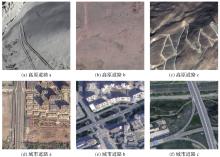
图1
典型高原道路与城市道路对比"

图2
SRENet结构"
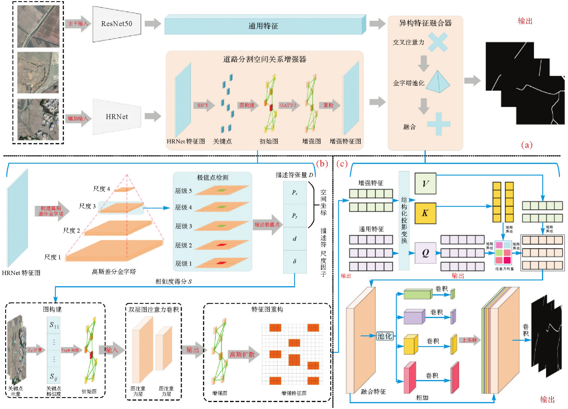
图3
关键点空间-语义相似性K近邻图"

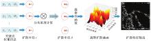
图4
基于可学习高斯核的特征扩散"
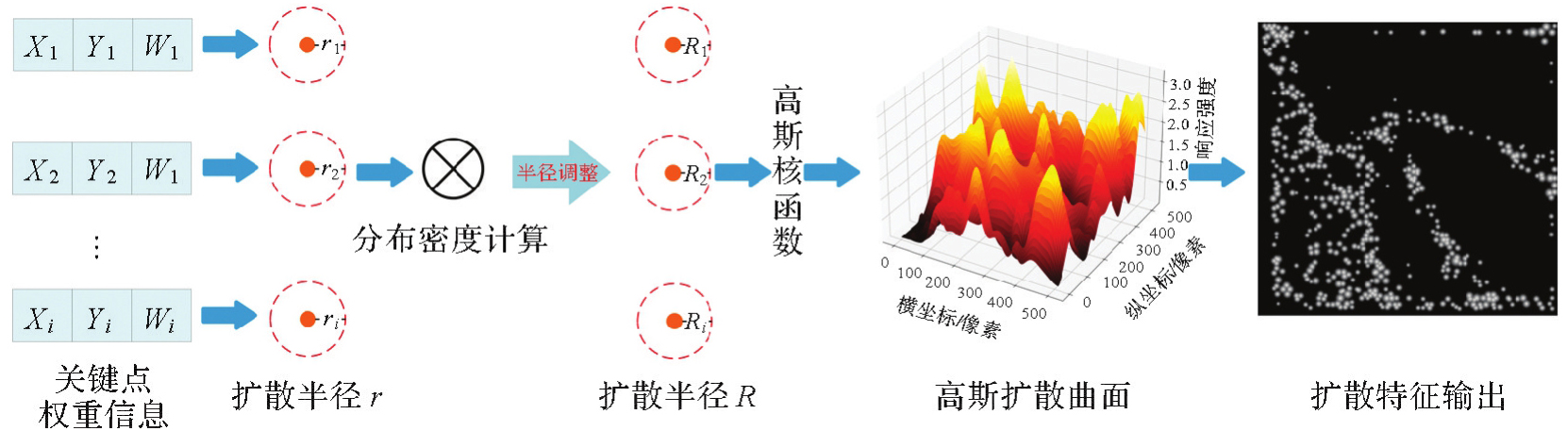
表1
数据集介绍"
| 数据集 | 数量/组 | 尺寸/像素 | 分辨率/m | 训练集/组 | 验证集/组 | 描述 |
|---|---|---|---|---|---|---|
| 扩充数据集 | 600 | 512×512 | 0.75 | 540 | 40 | 使用MakeSense基于像素级进行标注 |
| 吉林一号道路提取数据集 | 3800 | 512×512 | 0.75 | 3400 | 400 | 取原数据集训练集与扩充数据集构建新数据集(以下称“JL1-P”),共3800组 |
| DGRD | 6800 | 1024×1024 | 0.5 | 6100 | 700 | 取原数据集训练集与扩充数据集构建新数据集(以下称“DGRD-P”),共6800组 |
图5
扩充数据集"

图6
吉林一号道路提取数据集"

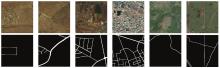
图7
DGRD数据集"
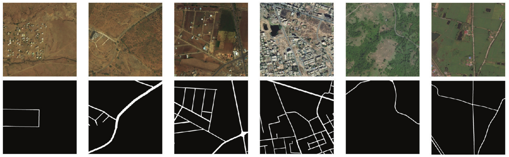
表2
对比试验结果"
| 数据集 | 网络 | IoU | Precision | Recall | F1值 |
|---|---|---|---|---|---|
| JL1-P | DeepLabV3+ | 0.558 9 | 0.745 2 | 0.682 1 | 0.692 0 |
| Mask2former | 0.612 1 | 0.760 9 | 0.754 4 | 0.740 6 | |
| SwinTransformer | 0.623 4 | 0.796 2 | 0.732 6 | 0.748 6 | |
| DLinkNet | 0.660 1 | 0.839 9 | 0.678 7 | 0.741 6 | |
| TransRoadNet | 0.684 0 | 0.845 0 | 0.785 8 | 0.802 7 | |
| SegRoadv2 | 0.688 6 | 0.850 1 | 0.787 0 | 0.803 6 | |
| SRENet(本文方法) | 0.700 2 | 0.840 1 | 0.791 3 | 0.805 4 | |
| DGRD-P | DeepLabV3+ | 0.479 5 | 0.758 5 | 0.566 9 | 0.639 4 |
| Mask2former | 0.602 1 | 0.742 9 | 0.7629 | 0.742 6 | |
| SwinTransformer | 0.611 0 | 0.760 7 | 0.758 8 | 0.748 9 | |
| DLinkNet | 0.620 2 | 0.766 3 | 0.766 6 | 0.756 8 | |
| TransRoadNet | 0.632 7 | 0.771 6 | 0.782 0 | 0.769 8 | |
| SegRoadv2 | 0.635 2 | 0.760 3 | 0.797 2 | 0.767 7 | |
| SRENet(本文方法) | 0.660 4 | 0.775 5 | 0.825 7 | 0.794 0 |
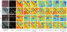
图8
特征图对比"

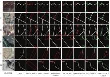
图9
JL1-P数据集上预测结果可视化对比"

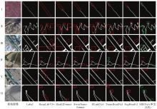
图10
DGRD-P数据集上预测结果可视化对比"

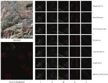
图11
大幅影像道路信息提取对比"

表3
消融试验结果"
| Net | HRNet | CA-HFM | SRE | Cnt_Loss | IoU | Precision | Recall | F1值 |
|---|---|---|---|---|---|---|---|---|
| Baseline0 | 0.441 1 | 0.754 8 | 0.481 0 | 0.558 3 | ||||
| Baseline1 | √ | 0.481 7 | 0.826 1 | 0.529 9 | 0.627 3 | |||
| Baseline2 | √ | √ | 0.539 3 | 0.759 4 | 0.649 8 | 0.693 3 | ||
| Baseline3 | √ | √ | √ | 0.623 4 | 0.796 2 | 0.732 6 | 0.748 6 | |
| Baseline4 | √ | √ | √ | √ | 0.700 2 | 0.840 1 | 0.791 3 | 0.805 4 |
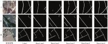
图12
消融试验可视化对比"
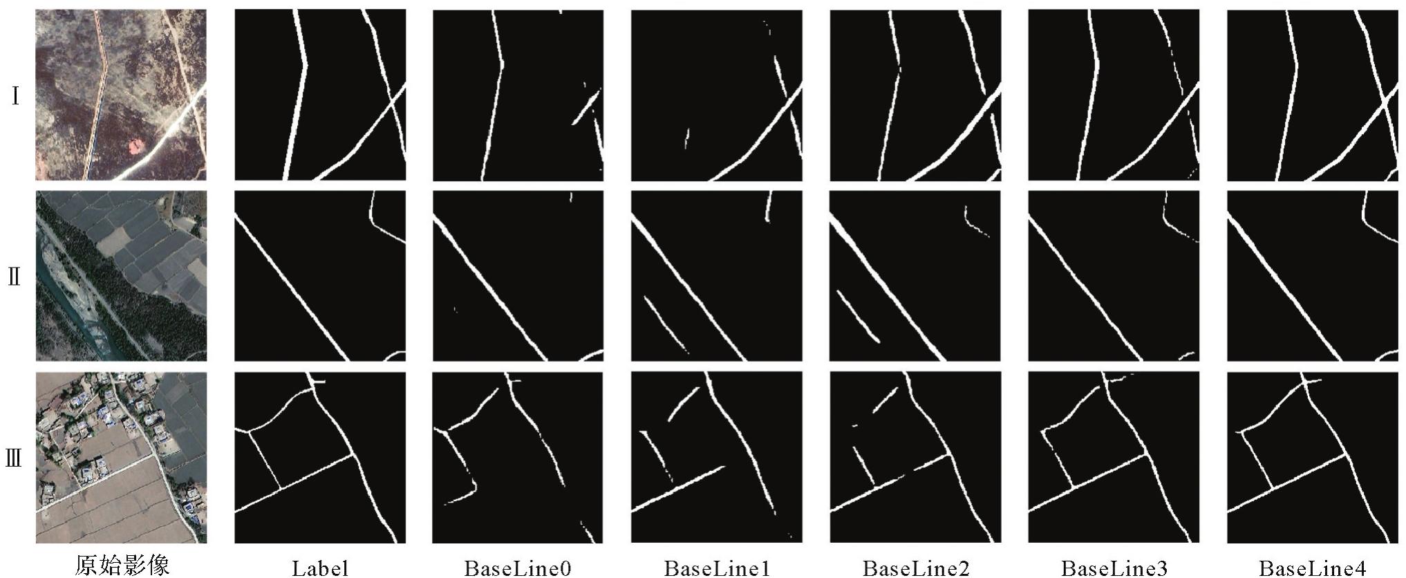
表4
扩充数据集消融试验结果"
| 网络 | 数据集 | IoU | Precision | Recall | F1值 |
|---|---|---|---|---|---|
| SRENet | JL1 | 0.673 0 | 0.805 4 | 0.751 8 | 0.766 1 |
| JL1-P | 0.700 2 | 0.840 1 | 0.791 3 | 0.805 4 | |
| DGRD | 0.623 | 0.749 4 | 0.775 0 | 0.751 3 | |
| DGRD-P | 0.660 4 | 0.775 5 | 0.825 7 | 0.794 0 | |
| DLinkNet | JL1 | 0.621 3 | 0.782 9 | 0.709 6 | 0.729 4 |
| JL1-P | 0.660 1 | 0.83 99 | 0.678 7 | 0.741 6 | |
| DGRD | 0.613 5 | 0.745 4 | 0.769 4 | 0.743 8 | |
| DGRD-P | 0.620 2 | 0.766 3 | 0.766 6 | 0.756 8 | |
| TransRoadNet | JL1 | 0.644 2 | 0.799 1 | 0.730 0 | 0.748 0 |
| JL1-P | 0.684 0 | 0.845 0 | 0.785 8 | 0.802 7 | |
| DGRD | 0.621 0 | 0.753 8 | 0.771 4 | 0.751 0 | |
| DGRD-P | 0.632 7 | 0.771 6 | 0.782 0 | 0.769 8 | |
| SegRoadv2 | JL1 | 0.662 0 | 0.805 3 | 0.748 9 | 0.764 2 |
| JL1-P | 0.688 6 | 0.850 1 | 0.7870 | 0.803 6 | |
| DGRD | 0.621 1 | 0.750 2 | 0.777 0 | 0.751 4 | |
| DGRD-P | 0.635 2 | 0.760 3 | 0.797 2 | 0.767 7 |
| [1] | MA Yaoming, ZHONG Lei, MA Weiqiang, et al. Determination of land surface heat fluxes at different temporal scales over the Tibetan Plateau[J]. Journal of Geodesy and Geoinformation Science, 2021(1): 144-152. |
| [2] | 李程. 遥感技术在农村公路核查中的应用研究[J]. 测绘与空间地理信息, 2018, 41(5): 48-49, 52. |
| LI Cheng. Application of remote sensing technology in rural road verification[J]. Geomatics & Spatial Information Technology, 2018, 41(5): 48-49, 52. | |
| [3] | 戴激光, 杜阳, 方鑫鑫, 等. 多特征约束的高分辨率光学遥感影像道路提取[J]. 遥感学报, 2018, 22(5): 777-791. |
| DAI Jiguang, DU Yang, FANG Xinxin, et al. Road extraction method for high resolution optical remote sensing images with multiple feature constraints[J]. Journal of Remote Sensing, 2018, 22(5): 777-791. | |
| [4] |
曹云刚, 王志盼, 慎利, 等. 像元与对象特征融合的高分辨率遥感影像道路中心线提取[J]. 测绘学报, 2016, 45(10): 1231-1240, 1249. DOI: .
doi: 10.11947/j.AGCS.2016.20160158 |
|
CAO Yungang, WANG Zhipan, SHEN Li, et al. Fusion of pixel-based and object-based features for road centerline extraction from high-resolution satellite imagery[J]. Acta Geodaetica et Cartographica Sinica, 2016, 45(10): 1231-1240, 1249. DOI: .
doi: 10.11947/j.AGCS.2016.20160158 |
|
| [5] | 张刚. 基于深度学习的遥感图像语义分割关键技术研究[D]. 成都: 中国科学院大学(中国科学院光电技术研究所), 2020. |
| ZHANG Gang. Research on key technologies of remote sensing image semantic segmentation based on deep learning[D]. Chengdu: Institute of Optics and Electronics, Chinese Academy of Sciences, 2020. | |
| [6] |
贺浩, 王仕成, 杨东方, 等. 基于Encoder-Decoder网络的遥感影像道路提取方法[J]. 测绘学报, 2019, 48(3): 330-338. DOI: .
doi: 10.11947/j.AGCS.2019.20180005 |
|
HE Hao, WANG Shicheng, YANG Dongfang, et al. An road extraction method for remote sensing image based on Encoder-Decoder network[J]. Acta Geodaetica et Cartographica Sinica, 2019, 48(3): 330-338. DOI: .
doi: 10.11947/j.AGCS.2019.20180005 |
|
| [7] |
王艳军, 唐徐超, 王成, 等. 基于道路拓扑关联特征的城乡道路面精细提取网络[J]. 测绘学报, 2025, 54(1): 75-89. DOI: .
doi: 10.11947/j.AGCS.2025.20240124 |
|
WANG Yanjun, TANG Xuchao, WANG Cheng, et al. Urban and rural road surface extraction network based on road topological correlation features[J]. Acta Geodaetica et Cartographica Sinica, 2025, 54(1): 75-89. DOI: .
doi: 10.11947/j.AGCS.2025.20240124 |
|
| [8] | MNIH V, HINTON G E. Learning to detect roads in high-resolution aerial images[C]//Proceedings of Computer Vision-ECCV 2010. Berlin: Springer, 2010: 210-223. |
| [9] | LI Peikang, ZANG Yu, WANG Cheng, et al. Road network extraction via deep learning and line integral convolution[C]//Proceedings of 2016 IEEE International Geoscience and Remote Sensing Symposium. Beijing: IEEE, 2016: 1599-1602. |
| [10] | CHENG Guangliang, ZHU Feiyun, XIANG Shiming, et al. Road centerline extraction via semisupervised segmentation and multidirection nonmaximum suppression[J]. IEEE Geoscience and Remote Sensing Letters, 2016, 13(4): 545-549. |
| [11] | WEI Yanan, WANG Zulin, XU Mai. Road structure refined CNN for road extraction in aerial image[J]. IEEE Geoscience and Remote Sensing Letters, 2017, 14(5): 709-713. |
| [12] | ALSHEHHI R, MARPU P R. Hierarchical graph-based segmentation for extracting road networks from high-resolution satellite images[J]. ISPRS Journal of Photogrammetry and Remote Sensing, 2017, 126: 245-260. |
| [13] | ZHOU Lichen, ZHANG Chuang, WU Ming. D-LinkNet: LinkNet with pretrained encoder and dilated convolution for high resolution satellite imagery road extraction[C]//Proceedings of 2018 IEEE/CVF Conference on Computer Vision and Pattern Recognition Workshops. Salt Lake City: IEEE, 2018: 182-186. |
| [14] | LI Jing, LIU Yong, ZHANG Yindan, et al. Cascaded attention DenseUNet (CADUNet) for road extraction from very-high-resolution images[J]. ISPRS International Journal of Geo-Information, 2021, 10(5): 329. |
| [15] | WU Qiangqiang, LUO Feng, WU Penghai, et al. Automatic road extraction from high-resolution remote sensing images using a method based on densely connected spatial feature-enhanced pyramid[J]. IEEE Journal of Selected Topics in Applied Earth Observations and Remote Sensing, 2020, 14: 3-17. |
| [16] | JIE Yongshi, HE Hongyan, XING Kun, et al. MECA-net: a multiscale feature encoding and long-range context-aware network for road extraction from remote sensing images[J]. Remote Sensing, 2022, 14(21): 5342. |
| [17] | ZHANG Zixuan, SUN Xuan, LIU Yuxi. GMR-net: road-extraction network based on fusion of local and global information[J]. Remote Sensing, 2022, 14(21): 5476. |
| [18] | ZHANG Yang, XIONG Zhangyue, ZANG Yu, et al. Topology-aware road network extraction via multi-supervised generative adversarial networks[J]. Remote Sensing, 2019, 11(9): 1017. |
| [19] | LI Xingang, WANG Yuebin, ZHANG Liqiang, et al. Topology-enhanced urban road extraction via a geographic feature-enhanced network[J]. IEEE Transactions on Geoscience and Remote Sensing, 2020, 58(12): 8819-8830. |
| [20] | HUANG Zilong, WANG Xinggang, HUANG Lichao, et al. CCNet: criss-cross attention for semantic segmentation[C]//Proceedings of 2019 IEEE/CVF International Conference on Computer Vision. Seoul: IEEE, 2019: 603-612. |
| [21] | CUI Fumin, SHI Yichang, FENG Ruyi, et al. A graph-based dual convolutional network for automatic road extraction from high resolution remote sensing images[C]//Proceedings of IGARSS 2022—2022 IEEE International Geoscience and Remote Sensing Symposium. Kuala Lumpur: IEEE, 2022: 3015-3018. |
| [22] | LU Xiaoyan, ZHONG Yanfei, ZHENG Zhuo, et al. Multi-scale and multi-task deep learning framework for automatic road extraction[J]. IEEE Transactions on Geoscience and Remote Sensing, 2019, 57(11): 9362-9377. |
| [23] | HE Wei, XUE Ruoyao, LU Fangxiao, et al. KDGraph: a keypoint detection method for road graph extraction from remote sensing images[J]. IEEE Transactions on Geoscience and Remote Sensing, 2024, 63: 5604814. |
| [24] | HE Kaiming, ZHANG Xiangyu, REN Shaoqing, et al. Deep residual learning for image recognition[C]//Proceedings of 2016 IEEE Conference on Computer Vision and Pattern Recognition. Las Vegas: IEEE, 2016: 770-778. |
| [25] | WANG Jingdong, SUN Ke, CHENG Tianheng, et al. Deep high-resolution representation learning for visual recognition[J]. IEEE Transactions on Pattern Analysis and Machine Intelligence, 2021, 43(10): 3349-3364. |
| [26] | VELICKOVIC P, CUCURULL G, CASANOVA A, et al. Graph attention networks[C]//Proceedings of 2018 International Conference on Learning Representations. Vancouver: [s. n.], 2018. |
| [27] | CHEN C R, FAN Quanfu, PANDA R. CrossViT: cross-attention multi-scale vision Transformer for image classification[C]//Proceedings of 2021 IEEE/CVF International Conference on Computer Vision. Montreal: IEEE, 2021: 347-356. |
| [28] | ZHAO Hengshuang, SHI Jianping, QI Xiaojuan, et al. Pyramid scene parsing network[C]//Proceedings of 2017 IEEE Conference on Computer Vision and Pattern Recognition. Honolulu: IEEE, 2017: 6230-6239. |
| [29] | DEMIR I, KOPERSKI K, LINDENBAUM D, et al. DeepGlobe 2018: a challenge to parse the Earth through satellite images[C]//Proceedings of 2018 IEEE/CVF Conference on Computer Vision and Pattern Recognition Workshops. Salt Lake City: IEEE, 2018: 172-17209. |
| [30] | CHEN L C, ZHU Yukun, PAPANDREOU G, et al. Encoder-decoder with atrous separable convolution for semantic image segmentation[C]//Proceedings of 2018 European Conference on Computer Vision. Cham: Springer, 2018: 833-851. |
| [31] | CHENG Bowen, MISRA I, SCHWING A G, et al. Masked-attention mask Transformer for universal image segmentation[C]//Proceedings of 2022 IEEE/CVF Conference on Computer Vision and Pattern Recognition. New Orleans: IEEE, 2022: 1280-1289. |
| [32] | LIU Ze, LIN Yutong, CAO Yue, et al. Swin Transformer: hierarchical vision Transformer using shifted windows[C]//Proceedings of 2021 IEEE/CVF International Conference on Computer Vision. Montreal: IEEE, 2021: 9992-10002. |
| [33] | YANG Zhigang, ZHOU Daoxiang, YANG Ying, et al. TransRoadNet: a novel road extraction method for remote sensing images via combining high-level semantic feature and context[J]. IEEE Geoscience and Remote Sensing Letters, 2022, 19: 6509505. |
| [34] | YU Zhengbo, CHEN Zhe, XIAO Keyan, et al. SegRoadv2: a hybrid deformable self-attention and convolutional network for road extraction with connectivity structure[J]. International Journal of Digital Earth, 2025, 18(1): 2480267. |
| [35] | ZHOU Bolei, KHOSLA A, LAPEDRIZA A, et al. Learning deep features for discriminative localization[C]//Proceedings of 2016 IEEE Conference on Computer Vision and Pattern Recognition. Las Vegas: IEEE, 2016: 2921-2929. |
| [1] | 徐永洋, 王健, 吴亮, 谢忠. 顾及道路边界与连通性的道路提取方法研究[J]. 测绘学报, 2025, 54(7): 1254-1264. |
| [2] | 万杰, 谢忠, 徐永洋, 陶留锋. 面向城市道路场景的车载LiDAR点云语义分割U形图卷积网络方法[J]. 测绘学报, 2025, 54(7): 1280-1293. |
| [3] | 杨文涛, 郭斐, 张小红, 张治宇, 朱逸凡, 李政, 吴子恒. 利用GNSS反射计和SMAP辐射计反演青藏高原土壤湿度和冻融状态[J]. 测绘学报, 2025, 54(4): 725-735. |
| [4] | 王艳军, 唐徐超, 王成, 蔡恒藩. 基于道路拓扑关联特征的城乡道路面精细提取网络[J]. 测绘学报, 2025, 54(1): 75-89. |
| [5] | 张付兵, 孙群, 马京振, 孙士杰, 温伯威. 融合全局和局部特征的建筑物形状智能分类方法[J]. 测绘学报, 2024, 53(9): 1842-1852. |
| [6] | 徐涛, 杨元维, 高贤君, 王志威, 潘越, 李少华, 许磊, 王艳军, 刘波, 余静, 吴凤敏, 孙浩宇. 融合图卷积与多尺度特征的接触网点云语义分割[J]. 测绘学报, 2024, 53(8): 1624-1633. |
| [7] | 韩潇然, 柯樱海, 于金媛, 赵孟杰, 张国庆. 基于SWOT卫星模拟数据的青藏高原湖泊水位与面积测量精度评估[J]. 测绘学报, 2024, 53(5): 823-834. |
| [8] | 周纪, 王子卫, 丁利荣, 唐文彬, 王伟, 马晋, 蒋蕙如, 刘双, 张涛, 侯映旭. 青藏高原冰冻圈温度遥感观测、反演与应用[J]. 测绘学报, 2024, 53(5): 835-847. |
| [9] | 杨梦娇, 赵伟, 詹琪琪, 张亚, 孟晓荣, 蔡俊飞, 杨羽佳. 基于偏相关分析的2003—2020年青藏高原地表温度变化驱动因子量化研究[J]. 测绘学报, 2024, 53(5): 848-859. |
| [10] | 马杜娟, 谢江流, 陈瑞, 严欣玉, 尹高飞. 青藏高原草地物候的空间尺度效应[J]. 测绘学报, 2024, 53(5): 860-868. |
| [11] | 孙根云, 孙超, 张爱竹. 融合多尺度与边缘特征的道路提取网络[J]. 测绘学报, 2024, 53(12): 2233-2243. |
| [12] | 肖天元, 艾廷华, 余华飞, 杨敏, 刘鹏程. 地图综合图卷积神经网络点群简化方法[J]. 测绘学报, 2024, 53(1): 158-172. |
| [13] | 安晓亚, 朱余德, 晏雄锋. 卷积神经网络支持下的建筑物选取方法[J]. 测绘学报, 2023, 52(9): 1574-1583. |
| [14] | 王培晓, 张彤, 聂士超, 杨瑾萱, 王天骄. 顾及缺失值的因果图时空预测网络[J]. 测绘学报, 2023, 52(5): 818-830. |
| [15] | 赵冰冰, 谭骁勇, 杨学习, 石岩, 邓敏. 融合地理条件驱动效应和图卷积的土地利用演化模拟CA模型[J]. 测绘学报, 2023, 52(5): 831-842. |
| 阅读次数 | ||||||
|
全文 |
|
|||||
|
摘要 |
|
|||||