


测绘学报 ›› 2026, Vol. 55 ›› Issue (5): 850-865.doi: 10.11947/j.AGCS.2026.20250474
钱妮佳1( ), 张迅1, 常国宾1,2,3(), 卞和方1, 杨化超1, 韩先楠2
收稿日期:2025-11-11
修回日期:2026-04-20
出版日期:2026-06-23
发布日期:2026-06-23
通讯作者:
常国宾
E-mail:nijiaqian@cumt.edu.cn;guobinchang@hotmail.com
作者简介:钱妮佳(1995—),男,博士,副教授,研究方向为重力场建模、卫星重力学、卫星导航定位应用等。 E-mail:nijiaqian@cumt.edu.cn
基金资助:
Nijia QIAN1(), Xun ZHANG1, Guobin CHANG1,2,3(), Hefang BIAN1, Huachao YANG1, Xiannan HAN2
Received:2025-11-11
Revised:2026-04-20
Online:2026-06-23
Published:2026-06-23
Contact:
Guobin CHANG
E-mail:nijiaqian@cumt.edu.cn;guobinchang@hotmail.com
About author:QIAN Nijia (1995—), male, PhD, associate professor, majors in gravity field modeling, satellite gravimetry, satellite navigation and positioning applications. E-mail: nijiaqian@cumt.edu.cn
Supported by:摘要:
最小二乘配置(LSC)是处理地球物理与大地测量数据的关键理论之一,但其需构建并求逆与观测数量同阶的稠密协方差矩阵,计算与存储开销制约了其在大规模观测条件下的应用。为突破该瓶颈,本文提出了一种基于贪婪算法的LSC稀疏近似算法:将LSC在稀疏表示框架下重构为稀疏系数恢复问题,并采用匹配追踪(MP)与正交匹配追踪(OMP)迭代求解,从而避免对全量稠密协方差矩阵的显式分解/求逆依赖。以美国科罗拉多州多源重力数据的大地水准面建模为例,结果表明本文算法外部检核精度(2.24 cm)与LSC(2.27 cm)相当;生成的稀疏模型仅需存储3.9%的系数,使预测阶段格网计算效率提升25倍以上,实现模型轻量化。进一步半仿真统计试验表明,在协方差参数由含噪数据估计导致模型失配加剧时,贪婪配置呈现更稳健的统计特征。本文方法在保持建模精度的同时提升了可扩展性,为大规模观测条件下的高精度重力场建模提供了一种计算可行的解决方案。
中图分类号:
钱妮佳, 张迅, 常国宾, 卞和方, 杨化超, 韩先楠. 最小二乘配置的贪婪稀疏近似算法[J]. 测绘学报, 2026, 55(5): 850-865.
Nijia QIAN, Xun ZHANG, Guobin CHANG, Hefang BIAN, Huachao YANG, Xiannan HAN. A greedy sparse approximation method for least squares collocation[J]. Acta Geodaetica et Cartographica Sinica, 2026, 55(5): 850-865.
图1
研究区概况注:绿色点表示地面重力观测,蓝色点表示航空重力观测,红色点表示GNSS/水准检核点,黑框范围为本文建模区域。"
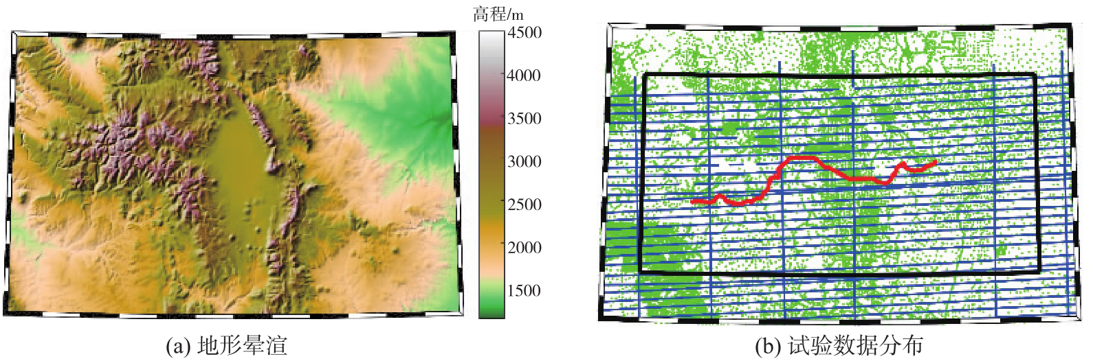
表1
参考重力场移去前后观测数据的统计特征"
| 数据类型 | STD | Max | Min | Mean |
|---|---|---|---|---|
| 地面重力δg | 36.72 | 207.89 | -92.86 | -3.26 |
| 地面重力δgres | 6.86 | 75.64 | -51.05 | 0.81 |
| 航空重力δg | 32.00 | 123.89 | -42.29 | 13.06 |
| 航空重力δgres | 3.54 | 18.28 | -16.57 | 0.36 |
图2
观测数据“移去”参考重力场前后数值分布"

表2
不同稀疏度下MP算法与OMP算法、LSC解算的大地水准面模型外部检核精度统计及解算时间"
| 算法 | 稀疏度 | 解算时间/h | 外部检验误差 | |||
|---|---|---|---|---|---|---|
| STD/cm | Max/cm | Min/cm | Mean/cm | |||
| LSC | 51 629 | 0.05 | 2.27 | 5.28 | -3.84 | 1.25 |
| MP | 477 | 0.04 | 2.49 | 5.90 | -4.33 | 0.96 |
| 1176 | 0.14 | 2.36 | 5.25 | -3.81 | 1.03 | |
| 1429 | 0.18 | 2.38 | 5.25 | -4.01 | 1.07 | |
| 2081 | 0.31 | 2.37 | 5.22 | -4.22 | 1.07 | |
| 2570 | 0.50 | 2.32 | 5.21 | -4.17 | 1.10 | |
| 3139 | 0.61 | 2.31 | 5.24 | -4.33 | 1.10 | |
| OMP | 500 | 0.06 | 2.39 | 5.28 | -3.99 | 1.32 |
| 1000 | 0.18 | 2.24 | 5.36 | -4.42 | 1.31 | |
| 1500 | 0.37 | 2.25 | 5.28 | -4.30 | 1.18 | |
| 2000 | 0.65 | 2.25 | 5.31 | -4.20 | 1.19 | |
图3
两种贪婪配置算法在不同稀疏度下的外部检核精度变化"
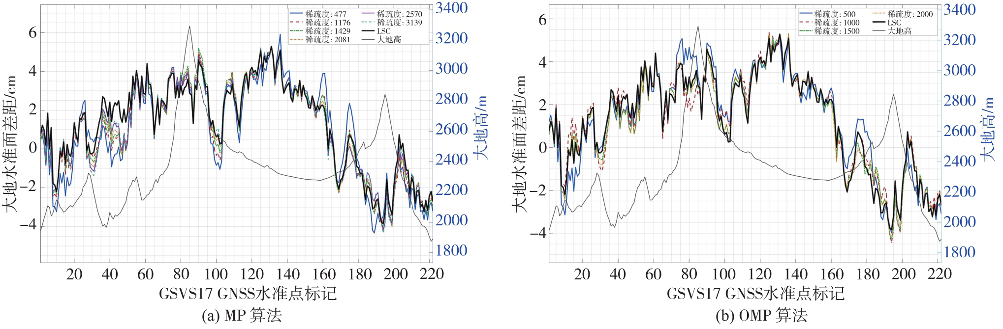
图4
不同稀疏度下MP算法与OMP算法、LSC与GSVS17大地水准面标准差异的标准差及解算时间"
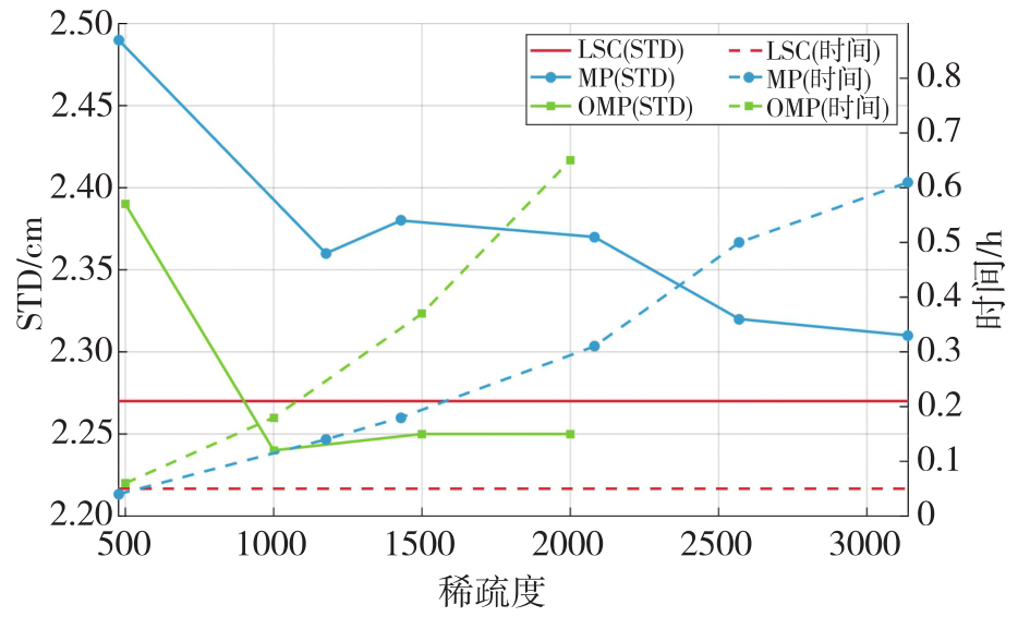
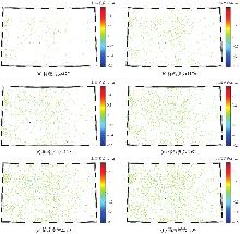
图5
MP算法在不同稀疏度下解算的非零系数空间分布"
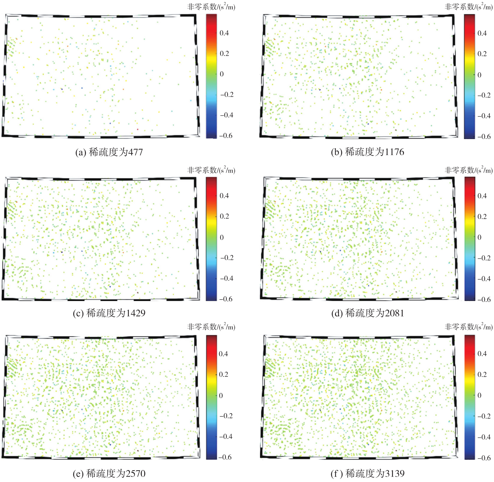
图6
OMP算法在不同稀疏度下解算的非零系数空间分布"
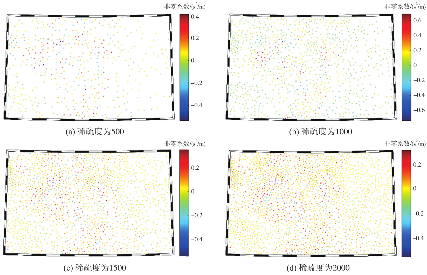
图7
LSC算法解算的系数空间分布"
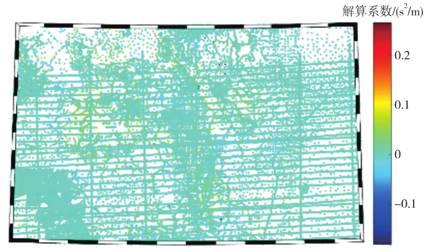
表3
不同算法对重力扰动观测值的拟合残差"
| 算法 | 稀疏度 | 残差/mGal | |||
|---|---|---|---|---|---|
| STD | Max | Min | Mean | ||
| LSC | 51 629 | 2.66 | 66.52 | -44.98 | 0.48 |
| MP | 477 | 3.37 | 70.09 | -48.44 | 0.59 |
| 1176 | 3.11 | 68.66 | -47.74 | 0.57 | |
| 1429 | 3.05 | 68.44 | -46.96 | 0.56 | |
| 2081 | 2.95 | 68.12 | -46.08 | 0.54 | |
| 2570 | 2.89 | 67.45 | -45.59 | 0.53 | |
| 3139 | 2.84 | 67.04 | -45.52 | 0.52 | |
| OMP | 500 | 3.05 | 68.19 | -45.43 | 0.52 |
| 1000 | 2.76 | 67.59 | -45.47 | 0.45 | |
| 1500 | 2.60 | 64.77 | -43.15 | 0.40 | |
| 2000 | 2.48 | 63.13 | -41.11 | 0.34 | |
图8
不同算法解算的重力扰动拟合残差空间分布"

图9
不同算法解算的剩余大地水准面及其差异注:表示MP算法在稀疏度为3139时得到的剩余大地水准面,表示OMP算法在稀疏度为2000时得到的剩余大地水准面,表示LSC算法计算得到的剩余大地水准面。"

表4
不同算法解算结果之间的格网大地水准面差值"
| 算法组合 | STD | Max | Min | Mean |
|---|---|---|---|---|
 | 0.34 | 1.78 | -2.64 | -0.02 |
 | 0.33 | 2.01 | -3.47 | -0.01 |
 | 0.26 | 1.86 | -2.10 | -0.02 |
图10
不同观测数量M下LSC与贪婪配置算法的求解阶段运行时间对比"
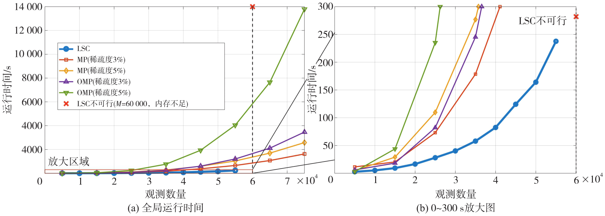
图11
不同观测数量M下LSC与贪婪配置算法的外部检核RMSE对比"
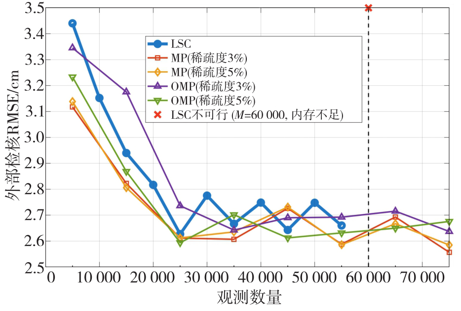
表5
50次重复试验下协方差失配与不同观测噪声条件下各算法检核大地水准面差STD的均值±标准差"
| 噪声STD | LSC(精确协方差) | LSC(经验协方差) | MP(3%) | MP(5%) | OMP(3%) | OMP(5%) |
|---|---|---|---|---|---|---|
| 1 mGal | 1.57±0.08 | 2.12±0.30 | 2.37±0.18 | 2.14±0.15 | 2.04±0.12 | 1.93±0.10 |
| 3 mGal | 2.23±0.12 | 2.95±0.40 | 2.59±0.22 | 2.30±0.18 | 2.20±0.13 | 2.06±0.12 |
| 5 mGal | 3.01±0.18 | 3.88±0.60 | 2.80±0.28 | 2.52±0.22 | 2.32±0.15 | 2.17±0.14 |
| [1] | HEISKANEN W A, MORITZ H. Physical geodesy[M]. San Francisco: W. H. Freeman, 1967. |
| [2] | 宁津生, 罗志才, 杨沾吉, 等. 深圳市1 km高分辨率厘米级高精度大地水准面的确定[J]. 测绘学报, 2003, 32(2): 102-107. |
| NING Jinsheng, LUO Zhicai, YANG Zhanji, et al. Determination of Shenzhen geoid with 1 km resolution and centimeter accuracy[J]. Acta Geodaetica et Cartographica Sinica, 2003, 32(2): 102-107. | |
| [3] |
李建成, 吴云龙, 姚宜斌, 等. 面向“数据-场景-模式”驱动的卫星重力技术研究进展、挑战与趋势[J]. 测绘学报, 2025, 54(9): 1537-1560. DOI: .
doi: 10.11947/j.AGCS.2025.20250274 |
|
LI Jiancheng, WU Yunlong, YAO Yibin, et al. Satellite gravity technology oriented towards data-scenario-model driven approach: developments, challenges and outlook[J]. Acta Geodaetica et Cartographica Sinica, 2025, 54(9): 1537-1560. DOI: .
doi: 10.11947/j.AGCS.2025.20250274 |
|
| [4] | 李建成. 最新中国陆地数字高程基准模型:重力似大地水准面CNGG2011[J]. 测绘学报, 2012, 41(5): 651-660, 669. |
| LI Jiancheng. The recent Chinese terrestrial digital height datum model: gravimetric quasi-geoid CNGG2011[J]. Acta Geodaetica et Cartographica Sinica, 2012, 41(5): 651-660, 669. | |
| [5] | 章传银, 郭春喜, 陈俊勇, 等. EGM 2008地球重力场模型在中国大陆适用性分析[J]. 测绘学报, 2009, 38(4): 283-289. |
| ZHANG Chuanyin, GUO Chunxi, CHEN Junyong, et al. EGM 2008 and its application analysis in Chinese mainland[J]. Acta Geodaetica et Cartographica Sinica, 2009, 38(4): 283-289. | |
| [6] | 孙文科. 低轨道人造卫星(CHAMP、GRACE、GOCE)与高精度地球重力场:卫星重力大地测量的最新发展及其对地球科学的重大影响[J]. 大地测量与地球动力学, 2002, 22(1): 92-100. |
| SUN Wenke. Satellite in low orbit (CHAMP, GRACE, GOCE) and high precision Earth gravity field: the latest progress of satellite gravity geodesy and its great influence on geoscience[J]. Journal of Geodesy and Geodynamics, 2002, 22(1): 92-100. | |
| [7] |
吴晓辉, 吴云龙, 徐国栋, 等. 一种顾及地理纬度空间互补的多域组合GRACE去条带滤波方法[J]. 测绘学报, 2024, 53(11): 2149-2165. DOI: .
doi: 10.11947/j.AGCS.2024.20240072 |
|
WU Xiaohui, WU Yunlong, XU Guodong, et al. A multi-domain combined GRACE de-striping filtering method taking in-to account spatial complementarity of geographic latitude[J]. Acta Geodaetica et Cartographica Sinica, 2024, 53(11): 2149-2165. DOI: .
doi: 10.11947/j.AGCS.2024.20240072 |
|
| [8] |
党亚民, 蒋涛, 杨元喜, 等. 中国大地测量研究进展(2019—2023)[J]. 测绘学报, 2023, 52(9): 1419-1436. DOI: .
doi: 10.11947/j.AGCS.2023.20230343 |
|
DANG Yamin, JIANG Tao, YANG Yuanxi, et al. Research progress of geodesy in China (2019—2023)[J]. Acta Geodaetica et Cartographica Sinica, 2023, 52(9): 1419-1436. DOI: .
doi: 10.11947/j.AGCS.2023.20230343 |
|
| [9] | 吴云龙, 李好, 张帆, 等. 西藏定日县Ms 6.8地震深部构造特征与孕震环境分析[J]. 武汉大学学报(信息科学版), 2025, 50(11): 2163-2175, 2186. |
| WU Yunlong, LI Hao, ZHANG Fan, et al. Analysis of deep tectonic characteristics and seismogenic environment of the Ms 6.8 earthquake in Dingri, Xizang, China[J]. Geomatics and Information Science of Wuhan University, 2025, 50(11): 2163-2175, 2186. | |
| [10] | 吴怿昊, 罗志才, 周波阳. 基于泊松小波径向基函数融合多源数据的局部重力场建模[J]. 地球物理学报, 2016, 59(3): 852-864. |
| WU Yihao, LUO Zhicai, ZHOU Boyang. Regional gravity modeling based on heterogeneous data sets by using Poisson wavelets radial basis functions[J]. Chinese Journal of Geophysics, 2016, 59(3): 852-864. | |
| [11] | 马志伟, 边少锋, 陆洋, 等. 融合多源重力数据构建局部高阶重力场模型[J]. 测绘科学, 2021, 46(6): 21-30. |
| MA Zhiwei, BIAN Shaofeng, LU Yang, et al. Regional high-degree gravity field modeling by combining multi-source gravity data[J]. Science of Surveying and Mapping, 2021, 46(6): 21-30. | |
| [12] | MORITZ H. Advanced physical geodesy[M]. Karlsruhe: Wichmann, 1980. |
| [13] | KRARUP T. A contribution to the mathematical foundation of physical geodesy[M]. Copenhagen: Geodesy Institute Copenhagen, 1969. |
| [14] | WANG Yanming, SÁNCHEZ L, ÅGREN J, et al. Colorado geoid computation experiment: overview and summary[J]. Journal of Geodesy, 2021, 95(12): 127. |
| [15] | ZINGERLE P, PAIL R, WILLBERG M, et al. A partition-enhanced least-squares collocation approach (PE-LSC)[J]. Journal of Geodesy, 2021, 95(8): 94. |
| [16] | SCHNEIDER N, MICHEL V. A dictionary learning add-on for spherical downward continuation[J]. Journal of Geodesy, 2022, 96(4): 21. |
| [17] | LIGAS M. Comparison of Kriging and least-squares collocation-revisited[J]. Journal of Applied Geodesy, 2022, 16(3): 217-227. |
| [18] | CHANG Guobin, BIAN Shaofeng. Least-squares collocation: a spherical harmonic representer theorem[J]. Geophysical Journal International, 2023, 234(2): 879-886. |
| [19] | MA Zhiwei. Gravity field modeling in mountainous areas based on band-limited SRBFs[J]. Journal of Geodesy, 2024, 98(5): 41. |
| [20] | DONOHO D L. For most large underdetermined systems of linear equations the minimal l1-norm solution is also the sparsest solution[J]. Communications on Pure and Applied Mathematics, 2006, 59(7): 797-829. |
| [21] | BAI Lanshu, LU Huiyi, LIU Yike. High-efficiency observations: compressive sensing and recovery of seismic waveform data[J]. Pure and Applied Geophysics, 2020, 177(1): 469-485. |
| [22] | 于会臻, 王金铎, 王千军. 基于密度模型稀疏表征的重力反演方法[J]. 地球物理学报, 2021, 64(3): 1061-1073. |
| YU Huizhen, WANG Jinduo, WANG Qianjun. Gravity inversion based on sparse representation of density model[J]. Chinese Journal of Geophysics, 2021, 64(3): 1061-1073. | |
| [23] | YU Haipeng, CHANG Guobin, ZHANG Shubi, et al. Application of sparse regularization in spherical radial basis functions-based regional geoid modeling in Colorado[J]. Remote Sensing, 2023, 15(19): 4870. |
| [24] | YU Haipeng, CHANG Guobin, ZHANG Shubi, et al. Sparsifying spherical radial basis functions based regional gravity models[J]. Journal of Spatial Science, 2022, 67(2): 297-312. |
| [25] | QIAN Nijia, CHANG Guobin, DITMAR P, et al. Sparse DDK: a data-driven decorrelation filter for GRACE level-2 products[J]. Remote Sensing, 2022, 14(12): 2810. |
| [26] | WU Xiaohui, WU Yunlong, XU Chuang, et al. A physically informed spatial filter for destriping GRACE time-variable gravity fields[J]. Geophysical Journal International, 2026, 245(1): ggag048. |
| [27] | MALLAT S G, ZHANG Zhifeng. Matching pursuits with time-frequency dictionaries[J]. IEEE Transactions on Signal Processing, 1993, 41(12): 3397-3415. |
| [28] | PATI Y C, REZAIIFAR R, KRISHNAPRASAD P S. Orthogonal matching pursuit: recursive function approximation with applications to wavelet decomposition[C]//Proceedings of 2002 Asilomar Conference on Signals, Systems and Computers. Pacific Grove: IEEE, 2002: 40-44. |
| [29] | TSCHERNING C C, RAPP R H. Closed covariance expressions for gravity anomalies, geoid undulations, and deflections of the vertical implied by anomaly degree variance models[R]. Columbus: Ohio State University, 1974. |
| [30] | KAULA W M. Theory of satellite geodesy: applications of satellites to geodesy[M]. London: Blaisdell Publishing Company, 1966. |
| [31] | VAN WESTRUM D, AHLGREN K, HIRT C, et al. A geoid slope validation survey (2017) in the rugged terrain of Colorado, USA[J]. Journal of Geodesy, 2021, 95(1): 9. |
| [32] | ZINGERLE P, PAIL R, GRUBER T, et al. The combined global gravity field model XGM2019e[J]. Journal of Geodesy, 2020, 94(7): 66. |
| [33] | PAVLIS N K, HOLMES S A, KENYON S C, et al. The development and evaluation of the Earth gravitational model 2008(EGM2008)[J]. Journal of Geophysical Research: Solid Earth, 2012, 117(B4): 2011JB008916. |
| [34] | HIRT C, KUHN M, CLAESSENS S, et al. Study of the Earth's short-scale gravity field using the ERTM2160 gravity model[J]. Computers & Geosciences, 2014, 73: 71-80. |
| [35] | MA Zhiwei, YANG Meng, LIU Jie. Regional gravity field modeling using band-limited SRBFs: a case study in Colorado[J]. Remote Sensing, 2023, 15(18): 4515. |
| [36] | 章传银, 丁剑, 晁定波. 局部重力场最小二乘配置通用表示技术[J]. 武汉大学学报(信息科学版), 2007, 32(5): 431-434. |
| ZHANG Chuanyin, DING Jian, CHAO Dingbo. General expression of least squares collocation in local gravity field[J]. Geomatics and Information Science of Wuhan University, 2007, 32(5): 431-434. | |
| [37] | KNUDSEN. Estimation and modelling of the local empirical covariance function using gravity and satellite altimeter data[J]. Bulletin Géodésique, 1987, 61(2): 145-160. |
| [1] | 章传银, 蒋涛, 柯宝贵. 统一于地固参考系的高程基准重力场理论基础与经典概念更新[J]. 测绘学报, 2025, 54(9): 1561-1571. |
| [2] | 陈海禄, 沈云中. GNSS辅助下的InSAR对流层延迟垂直分层与湍流分量联合改正模型[J]. 测绘学报, 2025, 54(10): 1786-1797. |
| [3] | 宋尚真, 杨怡欣, 王会峰, 王晓艳, 荣生辉, 周慧鑫. 高光谱图像稀疏约束与自编码器特征提取相结合的异常检测方法[J]. 测绘学报, 2023, 52(6): 932-943. |
| [4] | 赵闯, 金涛勇, 秦朋波, 杨连俊. 顾及残差约束的多面函数法融合卫星测高和船载重力[J]. 测绘学报, 2023, 52(4): 605-613. |
| [5] | 范雕, 李姗姗, 冯进凯, 黄炎, 范昊鹏, 张金辉, 李新星. 基于最小二乘配置的陌生海域海底地形反演方法[J]. 测绘学报, 2023, 52(12): 2039-2053. |
| [6] | 蒋涛, 党亚民, 郭春喜, 陈斌, 章传银. 国际高程参考系统在珠峰地区的实现[J]. 测绘学报, 2022, 51(8): 1757-1767. |
| [7] | 魏子卿. 第二大地边值问题引论[J]. 测绘学报, 2022, 51(6): 797-803. |
| [8] | 洪亮, 冯亚飞, 彭双云, 楚森森. 面向对象的多尺度加权联合稀疏表示的高空间分辨率遥感影像分类[J]. 测绘学报, 2022, 51(2): 224-237. |
| [9] | 黄谟涛, 邓凯亮, 吴太旗, 王伟平, 欧阳永忠, 陈欣, 王许. 广义带限航空矢量重力确定大地水准面的两步积分法[J]. 测绘学报, 2022, 51(11): 2245-2254. |
| [10] | 范雕, 李姗姗, 欧阳永忠, 孟书宇, 陈成, 邢志斌, 张驰. 顾及海底地形非线性项的最小二乘配置反演方法[J]. 测绘学报, 2021, 50(7): 953-971. |
| [11] | 党亚民, 郭春喜, 蒋涛, 张庆涛, 陈斌, 蒋光伟. 2020珠峰测量与高程确定[J]. 测绘学报, 2021, 50(4): 556-561. |
| [12] | 马健, 魏子卿, 任红飞. 确定似大地水准面的Hotine-Helmert边值解算模型[J]. 测绘学报, 2019, 48(2): 153-160. |
| [13] | 邢志斌, 李姗姗. 我国陆海统一似大地水准面构建的三维重力矢量法[J]. 测绘学报, 2018, 47(5): 575-583. |
| [14] | 许厚泽. 全球高程系统的统一问题[J]. 测绘学报, 2017, 46(8): 939-944. |
| [15] | 王忠美, 杨晓梅, 顾行发. 张量组稀疏表示的高光谱图像去噪算法[J]. 测绘学报, 2017, 46(5): 614-622. |
| 阅读次数 | ||||||
|
全文 |
|
|||||
|
摘要 |
|
|||||