| [1] |
许强, 董秀军, 李为乐. 基于天-空-地一体化的重大地质灾害隐患早期识别与监测预警[J]. 武汉大学学报(信息科学版), 2019, 44(7): 957-966.
|
|
XU Qiang, DONG Xiujun, LI Weile. Integrated space-air-ground early detection, monitoring and warning system for potential catastrophic geohazards[J]. Geomatics and Information Science of Wuhan University, 2019, 44(7): 957-966.
|
| [2] |
邵芸, 张茗, 谢酬. 地质灾害遥感综合监测现状与展望[J]. 地质与资源, 2022, 31(3): 381-394.
|
|
SHAO Yun, ZHANG Ming, XIE Chou. Present situation and prospect of comprehensive monitoring in geological hazard by remote sensing[J]. Geology and Resources, 2022, 31(3): 381-394.
|
| [3] |
孙文潇, 王健, 靳奉祥, 等. 变形分析中点云虚拟基准的确定方法[J]. 测绘学报, 2023, 52(6): 956-965. DOI: .
doi: 10.11947/j.AGCS.2023.20210463
|
|
SUN Wenxiao, WANG Jian, JIN Fengxiang, et al. Point cloud virtual datum determination method in deformation analysis[J]. Acta Geodaetica et Cartographica Sinica, 2023, 52(6): 956-965. DOI: .
doi: 10.11947/j.AGCS.2023.20210463
|
| [4] |
SHEN Nan, WANG Bin, MA Hongyang, et al. A review of terrestrial laser scanning (TLS)-based technologies for deformation monitoring in engineering[J]. Measurement, 2023, 223: 113684.
|
| [5] |
WU Chao, YUAN Yongbo, TANG Yang, et al. Application of terrestrial laser scanning (TLS) in the architecture, engineering and construction (AEC) industry[J]. Sensors, 2022, 22(1): 265.
|
| [6] |
TENG Jinlong, SHI Yufeng, WANG Helong, et al. Review on the research and applications of TLS in ground surface and constructions deformation monitoring[J]. Sensors, 2022, 22(23): 9179.
|
| [7] |
MUKUPA W, ROBERTS G W, HANCOCK C M, et al. A review of the use of terrestrial laser scanning application for change detection and deformation monitoring of structures[J]. Survey Review, 2016, 49(353): 99-116.
|
| [8] |
ZHAO Lidu, MA Xiaping, XIANG Zhongfu, et al. Landslide deformation extraction from terrestrial laser scanning data with weighted least squares regularization iteration solution[J]. Remote Sensing, 2022, 14(12): 2897.
|
| [9] |
陈弘奕, 胡晓斌, 李崇瑞. 地面三维激光扫描技术在变形监测中的应用[J]. 测绘通报, 2014(12): 74-77.
|
|
CHEN Hongyi, HU Xiaobin, LI Chongrui. Application of terrestrial 3D laser scanning technology in deformation monitoring[J]. Bulletin of Surveying and Mapping, 2014(12): 74-77.
|
| [10] |
YAN Li, WEI Pengcheng, XIE Hong, et al. A new outlier removal strategy based on reliability of correspondence graph for fast point cloud registration[J]. IEEE Transactions on Pattern Analysis and Machine Intelligence, 2023, 45(7): 7986-8002.
|
| [11] |
CHAN D O, XIAO Hang, XIA Linyuan, et al. Optimization of the use of spherical targets for point cloud registration using Monte Carlo simulation[J]. Journal of Geodesy and Geoinformation Science, 2024, 7(2): 18-36.
|
| [12] |
王英, 张云生. 一种由粗到精的地面激光点云多层级配准方法[J]. 测绘与空间地理信息, 2020, 43(2): 156-159.
|
|
WANG Ying, ZHANG Yunsheng. A multi-level registration method for terrestrial laser point cloud from coarse to fine[J]. Geomatics & Spatial Information Technology, 2020, 43(2): 156-159.
|
| [13] |
RUSU R B, BLODOW N, BEETZ M. Fast point feature histograms (FPFH) for 3D registration[C]//Proceedings of 2009 IEEE International Conference on Robotics and Automation. Kobe: IEEE, 2009: 3212-3217.
|
| [14] |
XU Yusheng, HUANG Rong, TONG Xiaohua, et al. Exploiting robust estimators in phase correlation of 3D point clouds for 6 DoF pose estimation[J]. Journal of Geodesy and Geoinformation Science, 2021, 4(3): 72-90.
|
| [15] |
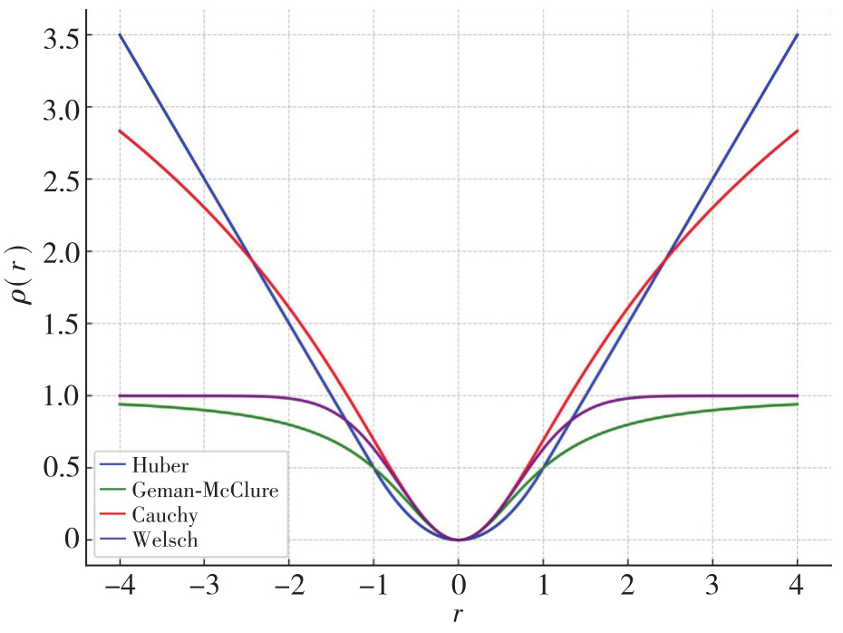
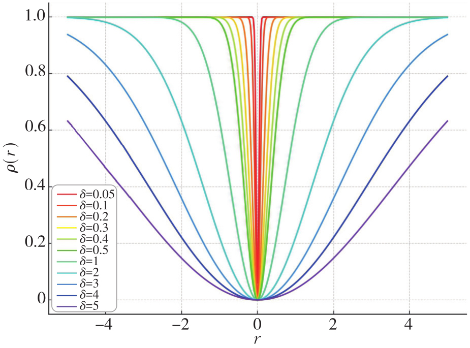
李加元, 张永军, 艾明耀, 等. 渐进性优化的尺度自适应Cauchy稳健估计模型及其应用[J]. 测绘学报, 2023, 52(1): 61-70. DOI: .
doi: 10.11947/j.AGCS.2023.20210415
|
|
LI Jiayuan, ZHANG Yongjun, AI Mingyao, et al. Scale-adaptive Cauchy robust estimation based on progressive optimization and its applications[J]. Acta Geodaetica et Cartographica Sinica, 2023, 52(1): 61-70. DOI: .
doi: 10.11947/j.AGCS.2023.20210415
|
| [16] |
FISCHLER M A, BOLLES R C. Random sample consensus: a paradigm for model fitting with applications to image analysis and automated cartography[J]. Communications of the ACM, 1981, 24(6): 381-395.
|
| [17] |
YANG Heng, ANTONANTE P, TZOUMAS V, et al. Graduated non-convexity for robust spatial perception: from non-minimal solvers to global outlier rejection[J]. IEEE Robotics and Automation Letters, 2020, 5(2): 1127-1134.
|
| [18] |
BESL P J, MCKAY N D. A method for registration of 3D shapes[J]. IEEE Transactions on Pattern Analysis and Machine Intelligence, 1992, 14(2): 239-256.
|
| [19] |
CHEN Yang, MEDIONI G. Object modelling by registration of multiple range images[J]. Image and Vision Computing, 1992, 10(3): 145-155.
|
| [20] |
BAI Xuyang, LUO Zixin, ZHOU Lei, et al. PointDSC: robust point cloud registration using deep spatial consistency[C]//Proceedings of 2021 IEEE/CVF Conference on Computer Vision and Pattern Recognition. Nashville: IEEE, 2021: 15854-15864.
|
| [21] |
LAGUE D, BRODU N, LEROUX J. Accurate 3D comparison of complex topography with terrestrial laser scanner: application to the Rangitikei canyon (N-Z)[J]. ISPRS Journal of Photogrammetry and Remote Sensing, 2013, 82: 10-26.
|
| [22] |
WINIWARTER L, ANDERS K, HÖFLE B. M3C2-EP: pushing the limits of 3D topographic point cloud change detection by error propagation[J]. ISPRS Journal of Photogrammetry and Remote Sensing, 2021, 178: 240-258.
|
| [23] |
ZAHS V, WINIWARTER L, ANDERS K, et al. Correspondence-driven plane-based M3C2 for lower uncertainty in 3D topographic change quantification[J]. ISPRS Journal of Photogrammetry and Remote Sensing, 2022, 183: 541-559.
|
| [24] |
YANG Yihui, SCHWIEGER V. Patch-based M3C2: towards lower-uncertainty and higher-resolution deformation analysis of 3D point clouds[J]. International Journal of Applied Earth Observation and Geoinformation, 2023, 125: 103535.
|
| [25] |
荣延祥, 龚正, 陈泽权, 等. 一种由粗到精的边坡形变检测方法[J]. 测绘通报, 2021(6): 93-97.
|
|
RONG Yanxiang, GONG Zheng, CHEN Zequan, et al. A coarse-to-fine method for slope deformation detection[J]. Bulletin of Surveying and Mapping, 2021(6): 93-97.
|
| [26] |
ARUN K S, HUANG T S, BLOSTEIN S D. Least-squares fitting of two 3D point sets[J]. IEEE Transactions on Pattern Analysis and Machine Intelligence, 1987, 9(5): 698-700.
|
| [27] |
BLACK M J, RANGARAJAN A. On the unification of line processes, outlier rejection, and robust statistics with applications in early vision[J]. International Journal of Computer Vision, 1996, 19(1): 57-91.
|
| [28] |
ANDERSON D G. Iterative procedures for nonlinear integral equations[J]. Journal of the ACM, 1965, 12(4): 547-560.
|
| [29] |
TOTH A, KELLEY C T. Convergence analysis for Anderson acceleration[J]. SIAM Journal on Numerical Analysis, 2015, 53(2): 805-819.
|
| [30] |
ZHENG Jinjun, XIANG Man, ZHANG Tao, et al. An improved adaptive grid-based progressive triangulated irregular network densification algorithm for filtering airborne LiDAR data[J]. Remote Sensing, 2024, 16(20): 3846.
|
| [31] |
王凯, 支煜, 陈浩, 等. 一种基于Graham扫描算法的空间点云结构化算法研究[J]. 现代电子技术, 2018, 41(14): 139-142, 146.
|
|
WANG Kai, ZHI Yu, CHEN Hao, et al. Research on space point cloud structuring algorithm based on Graham scanning algorithm[J]. Modern Electronics Technique, 2018, 41(14): 139-142, 146.
|
| [32] |
DAS B M. Principles of foundation engineering[M]. 8th ed. Stamford: Cengage Learning, 2016.
|
| [33] |
ABELLÁN A, JABOYEDOFF M, OPPIKOFER T, et al. Detection of millimetric deformation using a terrestrial laser scanner: experiment and application to a rockfall event[J]. Natural Hazards and Earth System Sciences, 2009, 9(2): 365-372.
|
| [34] |
KROMER R A, ABELLÁN A, HUTCHINSON D J, et al. A 4D filtering and calibration technique for small-scale point cloud change detection with a terrestrial laser scanner[J]. Remote Sensing, 2015, 7(10): 13029-13052.
|
| [35] |
ABDEL-MAKSOUD H, AZIZ T A, ELSHARKAWY A S, et al. Advanced techniques for precision assessment in UAV LiDAR systems[J]. Journal of Geodesy and Geoinformation Science, 2025, 8(2): 90-107.
|


 ), 蒋贵宇1,2, 沈航毅1,2, 黄海峰1,2, 张溶玲3(