


测绘学报 ›› 2026, Vol. 55 ›› Issue (6): 1087-1100.doi: 10.11947/j.AGCS.2026.20250428
• 大型工程基础设施测绘与地下空间智能感知 • 上一篇
陈智鹏1,2,3,4( ), 吕世望5, 王新一1,2,3,4()
收稿日期:2025-10-11
修回日期:2026-05-21
发布日期:2026-07-28
通讯作者:
王新一
E-mail:chenzp1990@szu.edu.cn;854756740@qq.com
作者简介:陈智鹏(1990—),男,博士,副教授,研究方向为组合定位、动态精密工程测量。E-mail:chenzp1990@szu.edu.cn
基金资助:
Zhipeng CHEN1,2,3,4(), Shiwang LÜ5, Xinyi WANG1,2,3,4()
Received:2025-10-11
Revised:2026-05-21
Published:2026-07-28
Contact:
Xinyi WANG
E-mail:chenzp1990@szu.edu.cn;854756740@qq.com
About author:CHEN Zhipeng (1990—), male, PhD, associate professor, majors in integrated positioning and dynamic precision engineering surveying. E-mail: chenzp1990@szu.edu.cn
Supported by:摘要:
轨道、管道、桥梁等长距离线性工程的线形精密测量是运维安全的重要保障。近年来,惯性组合线形测量兼具高效、高精度的优势,在线形变化监测中逐渐广泛应用。但该测量方式的误差具有强非线性、多源耦合、时空累积特征,传统解析法难以精准量化分析。针对该工程痛点,本文提出了一种基于蒙特卡洛的误差仿真与精度评估方法:首先,采用样条函数拟合结合惯性编排反算实现轨迹高保真生成;其次,构建多源误差耦合模型并通过蒙特卡洛方法注入真实传感器误差;然后,利用卡尔曼滤波结合RTS平滑完成轨迹重构;最后,借助误差椭圆实现线形测量误差的可视化评估。分别对大坝内部预埋管道、铁路轨道等直线、U形线性结构测量开展仿真,结合大坝管道实测数据验证,仿真与实测数据平均相关性达87.3%。试验进一步分析了传感器精度、运动速度及控制点间距等因素对测量精度的影响规律。本文构建了“轨迹生成—误差注入—轨迹重构—精度评估”一体化方法体系,可有效支撑传感器选型、控制点布设等工程方案优化,为长距离线性工程变形监测提供技术参考。
中图分类号:
陈智鹏, 吕世望, 王新一. 惯性组合线形测量误差仿真与精度评估方法[J]. 测绘学报, 2026, 55(6): 1087-1100.
Zhipeng CHEN, Shiwang LÜ, Xinyi WANG. Error simulation and accuracy evaluation method for integrated inertial alignment measurement[J]. Acta Geodaetica et Cartographica Sinica, 2026, 55(6): 1087-1100.
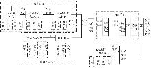
图1
基于蒙特卡洛的线形测量精度仿真预测方法技术路线"

图2
预设理论测量轨迹生成方法"


表1
坐标系定义"
| 坐标系符号 | 坐标系符号 |
|---|---|
| 地心惯性坐标系 | i系 |
| 载体坐标系 | b系 |
| 当地水平导航坐标系 | n系 |
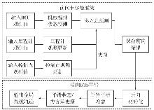
图3
前向Kalman滤波-后向RTS平滑融合算法流程"
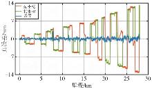
图4
KF-GINS数据集轨迹线形里程-真误差"
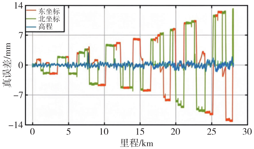
表2
KF-GINS轨迹线形误差"
| 统计值 | 东坐标 | 北坐标 | 高程 |
|---|---|---|---|
| 最大值 | 12.64 | 13.22 | 2.93 |
| 最小值 | -13.23 | -11.17 | -1.52 |
| 平均值 | -0.04 | -0.15 | 0.01 |
表3
仿真数据保真度对比"
| 方法 | 东坐标RMSE/mm | 北坐标RMSE/mm | 高程RMSE/mm | 相对精度 |
|---|---|---|---|---|
| 本文方法 | 3.21 | 3.57 | 0.89 | 0.23×10⁻⁶ |
| 方法1 | 28.65 | 31.24 | 5.72 | 2.17×10⁻⁶ |
| 方法2 | 15.32 | 16.87 | 3.24 | 1.12×10⁻⁶ |
表4
工程适用性对比"
| 对比维度 | 本文方法 | 方法1 | 方法2 |
|---|---|---|---|
| 复杂形状线性工程仿真 | 是 | 否 | 是(但精度低) |
| 多源误差耦合建模 | 是 | 否 | 是(但线性近似) |
| 误差空间分布可视化 | 是 | 否 | 否 |
| 测量方案优化 | 是 | 否 | 有限 |
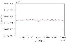
图5
直线形轨迹模拟平面误差椭圆"
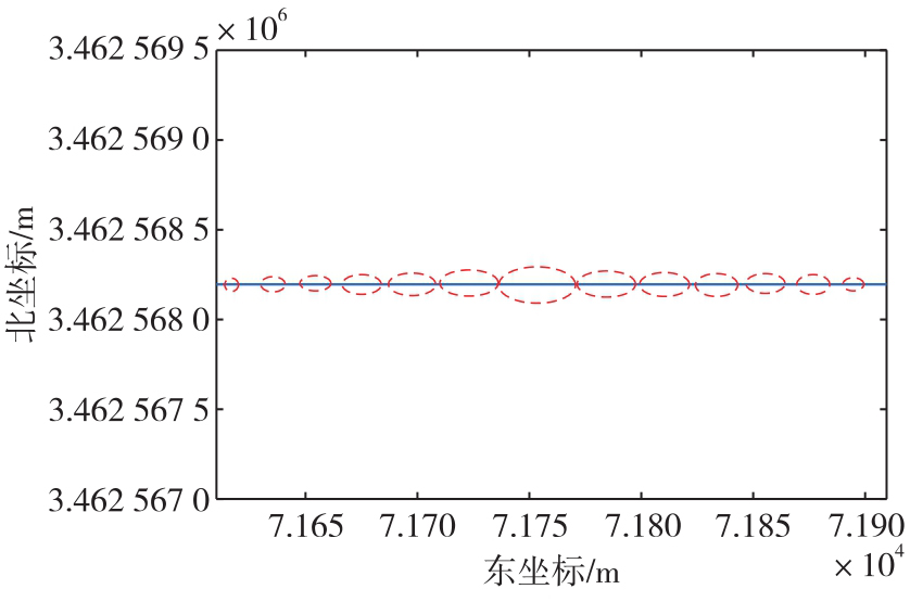
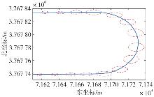
图6
U形轨迹模拟平面误差椭圆"
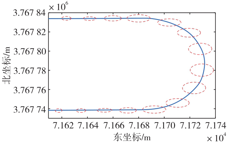
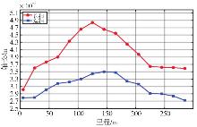
图7
直线形轨迹误差椭圆长短轴变化趋势"
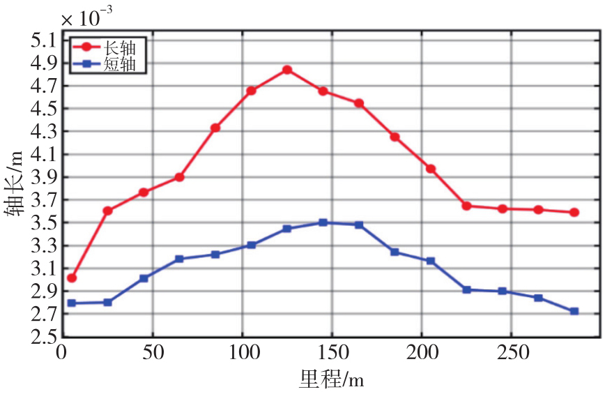
图8
U形轨迹误差椭圆长短轴变化趋势"
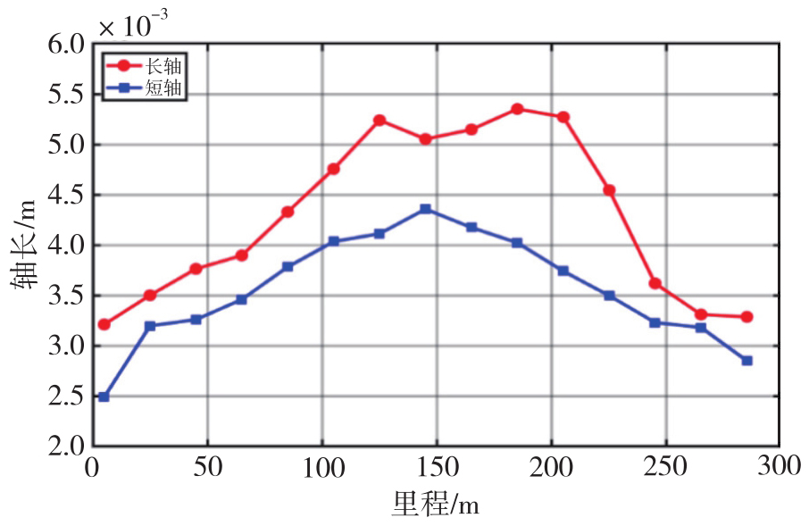
表5
模拟轨迹平面误差椭圆长短轴参数"
| 线形 | 管长/m | 有效椭圆数 | 轴 | 平均轴长/m | 最大轴长/m |
|---|---|---|---|---|---|
| 直线形 | 300 | 15 | 长轴 | 0.004 0 | 0.004 8 |
| 短轴 | 0.003 1 | 0.003 5 | |||
| U形 | 300 | 15 | 长轴 | 0.004 2 | 0.005 3 |
| 短轴 | 0.003 5 | 0.004 3 |
图9
试验管道线形"
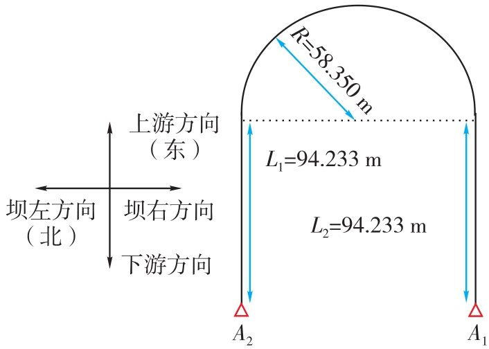
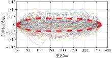
图10
管道模拟线形里程-东坐标误差"
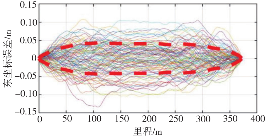
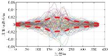
图11
管道模拟线形里程-北坐标误差"
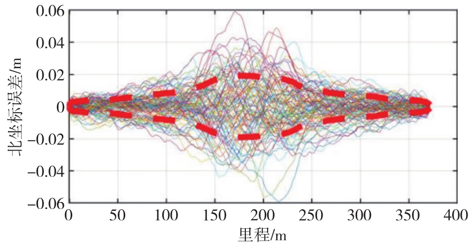
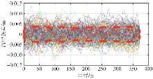
图12
管道模拟线形里程-高程误差"
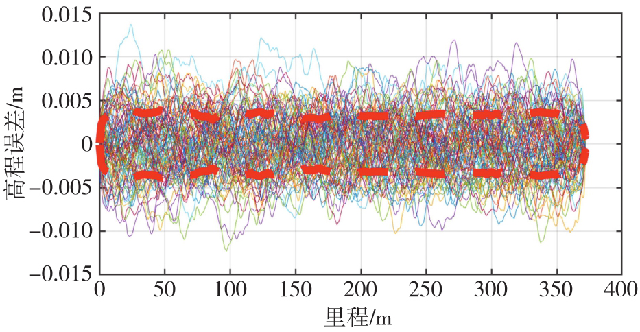
表6
实测-仿真管道线形精度对比"
| 方向 | 实测线形重复性/mm | 仿真线形重复性/mm | 实测-仿真相关性/(%) |
|---|---|---|---|
| 东方向 | 34.58 | 29.81 | 86.2 |
| 北方向 | 12.22 | 10.24 | 83.9 |
| 高程方向 | 4.16 | 3.82 | 91.8 |
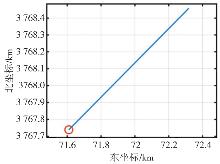
图13
仿真直线轨迹平面"
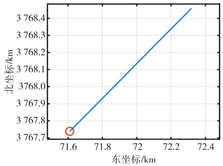
表7
不同精度等级的IMU、里程计和控制点"
| 精度分级 | IMU(型号) | 里程计速度中误差/(m/s) | 控制点坐标中误差/m |
|---|---|---|---|
| 高精度 | 导航级(kz50) | 0.005 | [0.001 0.001 0.001] |
| 中精度 | 战术级(stim300 10g) | 0.05 | [0.01 0.01 0.01] |
| 低精度 | 工业级(i300BA50) | 0.5 | [0.3 0.3 0.05] |
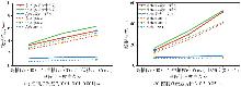
图14
导航级IMU在不同里程计、控制点精度配置组合条件下的线形精度"
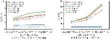
图15
战术级IMU在不同里程计、控制点精度配置组合条件下的线形精度"
图16
工业级IMU在不同里程计、控制点精度配置组合条件下的线形精度"
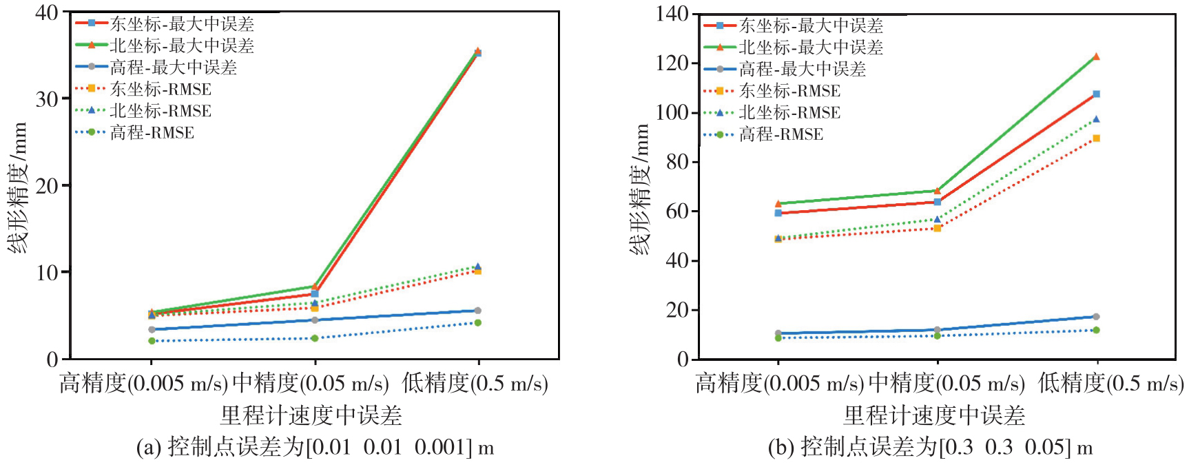
图17
最大运动速度与线形精度关系"
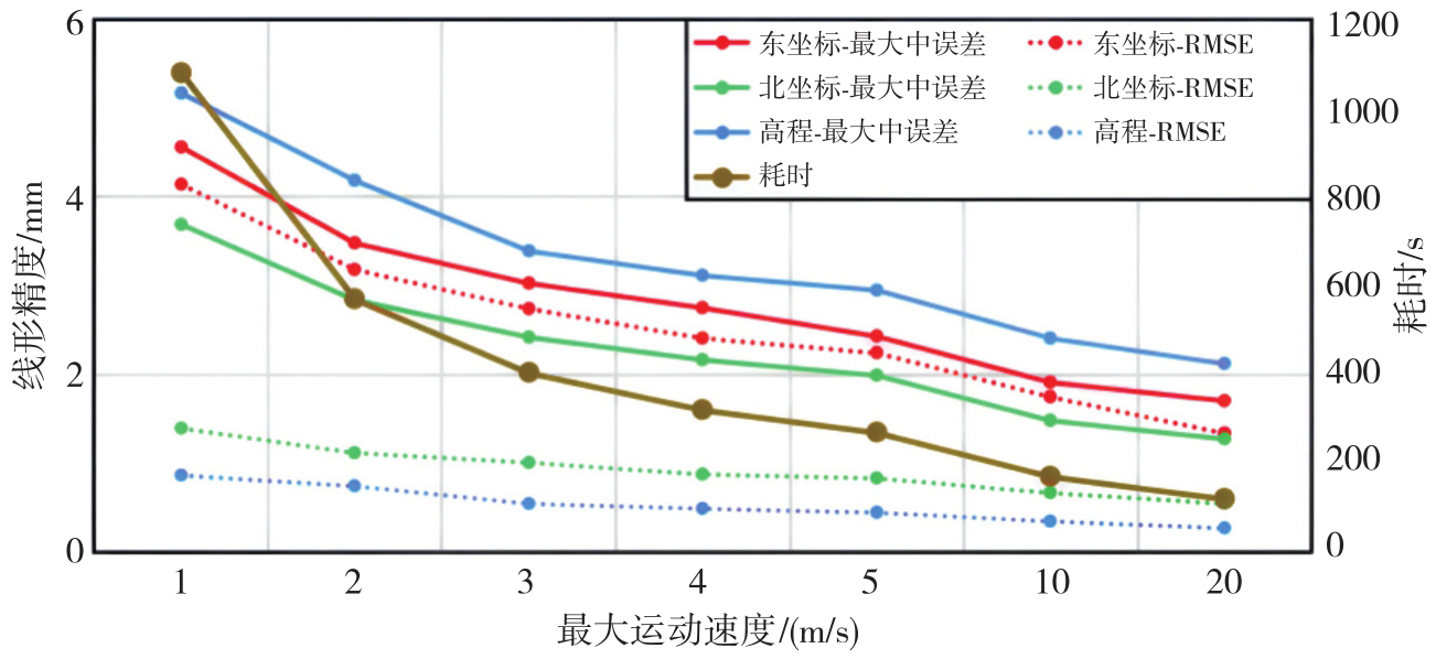
图18
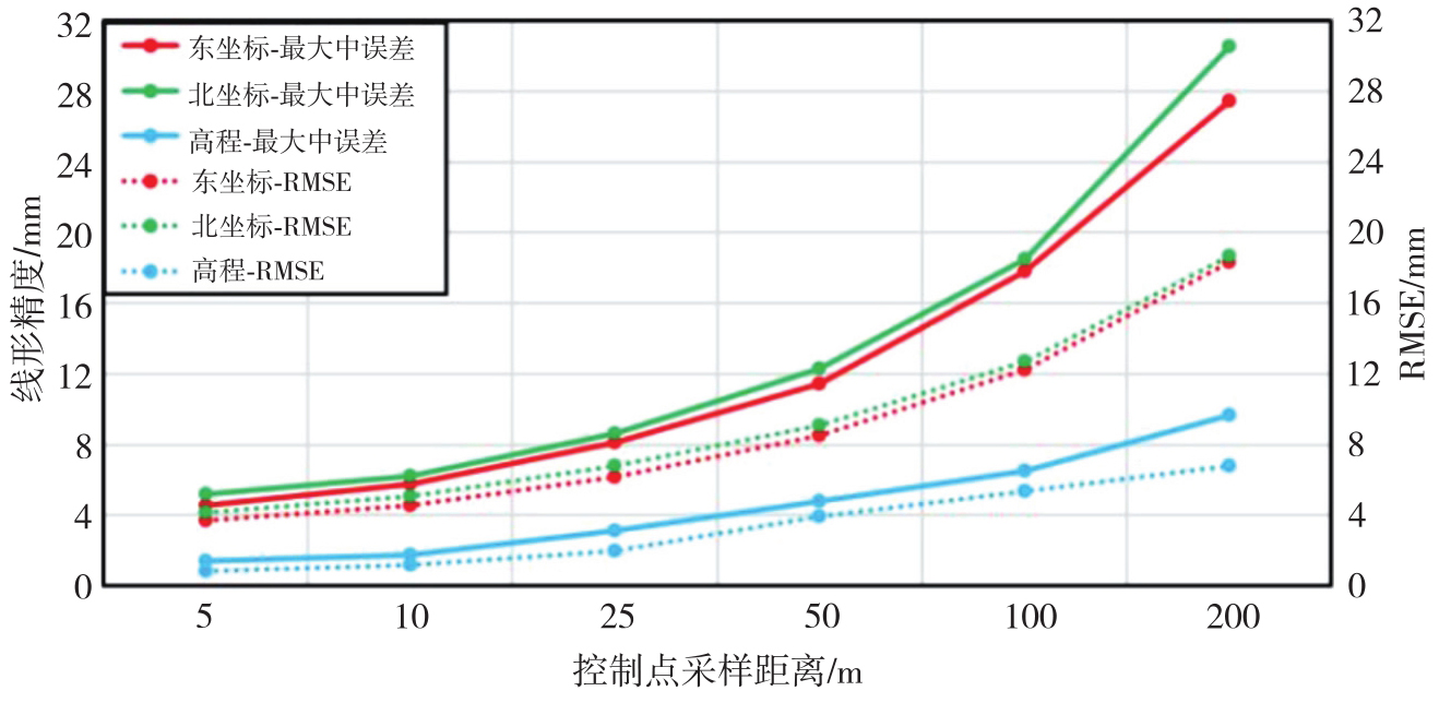
控制点采样距离与线形精度关系"
| [1] | 许俊伟, 刘永胜, 吴达, 等. 隧道与地下工程监控量测技术的发展与展望[J]. 测绘地理信息, 2023, 48(3): 7-13. |
| XU Junwei, LIU Yongsheng, WU Da, et al. Development and outlook of monitoring and measuring technologies of tunnel and underground engineering[J]. Journal of Geomatics, 2023, 48(3): 7-13. | |
| [2] | 钮新强. 高面板堆石坝安全与思考[J]. 水力发电学报, 2017, 36(1): 104-111. |
| NIU Xinqiang. Security of high concrete face rockfill dam consideration and conclusion[J]. Journal of Hydroelectric Engineering, 2017, 36(1): 104-111. | |
| [3] | 邹青, 谭志伟, 张礼兵, 等. 200 m级高面板堆石坝安全监测技术调查与总结报告[EB/OL]. [2025-10-03]. https://max.book118.com/html/2015/0829/24279761.shtm. |
| ZOU Qing, TAN Zhiwei, ZHANG Libing, et al. Investigation and summary report on safety monitoring technology for 200 m high CFRD[EB/OL]. [2025-10-03]. https://max.book118.com/html/2015/0829/24279761.shtm. | |
| [4] | 贾金生, 郦能惠, 徐泽平. 高混凝土面板坝安全关键技术研究[M]. 北京: 中国水利水电出版社, 2014. |
| JIA Jinsheng, LI Nenghui, XU Zeping. Research on key safety technologies of high concrete face rockfill dams[M]. Beijing: China Water & Power Press, 2014. | |
| [5] | 邹青. 中国高面板堆石坝安全监测关键技术进展与展望[J]. 大坝与安全, 2016(1): 50-56. |
| ZOU Qing. Progress and prospect of key technologies in safety monitoring of high face slab rockfill dams in China[J]. Dam & Safety, 2016(1): 50-56. | |
| [6] | 李之中, 刘冠军. 引张线式水平位移计系统误差分析[J]. 水电自动化与大坝监测, 2009(6): 62-64. |
| LI Zhizhong, LIU Guanjun. System error analysis of alignment horizontal displacement equipment[J]. Hydropower Automation and Dam Monitoring, 2009(6): 62-64. | |
| [7] | 陈起金. 基于A-INS组合导航的铁路轨道几何状态精密测量技术研究[D]. 武汉: 武汉大学, 2016. |
| CHEN Qijin. Research on precise measurement technology of railway track geometric state based on A-INS integrated navigation[D]. Wuhan: Wuhan University, 2016. | |
| [8] | 李清泉, 陈智鹏, 殷煜, 等. 一种管道三维曲线测量机器人及其实现方法: CN109780370B[P]. 2020-05-26. |
| LI Qingquan, CHEN Zhipeng, YIN Yu, et al. A pipeline 3D curve measurement robot and its implementation method: CN109780370B[P]. 2020-05-26. | |
| [9] | 殷煜, 陈智鹏, 李清泉, 等. 高精度管线测量机器人多传感器集成方法[J]. 电子测量技术, 2019, 42(2): 23-27. |
| YIN Yu, CHEN Zhipeng, LI Qingquan, et al. Multi sensor integration method for high precision pipeline survey robot[J]. Electronic Measurement Technology, 2019, 42(2): 23-27. | |
| [10] | 殷煜. 高精度管道测量机器人多传感器集成系统设计与实现[D]. 武汉: 华中师范大学, 2019. |
| YIN Yu. Design and implementation of multi-sensor integrated system for high precision pipeline measurement robot[D]. Wuhan: Central China Normal University, 2019. | |
| [11] | 李清泉, 吕世望, 陈智鹏, 等. 冬奥会国家速滑馆超大地坪平整度快速测量[J]. 武汉大学学报(信息科学版), 2022, 47(3): 325-333. |
| LI Qingquan, LÜ Shiwang, CHEN Zhipeng, et al. Rapid measurement of flatness of oversized floor of speed skating oval in winter Olympic games[J]. Geomatics and Information Science of Wuhan University, 2022, 47(3): 325-333. | |
| [12] | 张绍成, 殷飞, 胡俊亮, 等. GPS/BDS-RTK与惯导组合实现大型桥梁垂向线形测量[J]. 测绘科学, 2022, 47(6): 1-7. |
| ZHANG Shaocheng, YIN Fei, HU Junliang, et al. Large bridge vertical alignment surveying with GPS/BDS-RTK and INS integration[J]. Science of Surveying and Mapping, 2022, 47(6): 1-7. | |
| [13] | 林朋皓. 基于惯性导航系统的非开挖铺管轨迹测量技术研究与应用[D]. 武汉: 中国地质大学, 2023. |
| LIN Penghao. Research and application of trenchless pipeline trajectory mapping technology based on inertial navigation system[D]. Wuhan: China University of Geosciences, 2023. | |
| [14] | GROVES P D. Principles of GNSS, inertial, and multisensor integrated navigation systems[M]. Boston: Artech House, 2013. |
| [15] | LASHLEY M, BEVLY D M, HUNG J Y. Analysis of deeply integrated and tightly coupled architectures[C]//Proceedings of 2010 IEEE/ION Position Location and Navigation Symposium. Indian Wells: IEEE, 2010: 382-393. |
| [16] | CADENA C, CARLONE L, CARRILLO H, et al. Past, present, and future of simultaneous localization and mapping: toward the robust-perception age[J]. IEEE Transactions on Robotics, 2016, 32(6): 1309-1332. |
| [17] | BARSHAN B, DURRANT-WHYTE H F. Inertial navigation systems for mobile robots[J]. IEEE Transactions on Robotics and Automation, 1995, 11(3): 328-342. |
| [18] | FOXLIN E. Pedestrian tracking with shoe-mounted inertial sensors[J]. IEEE Computer Graphics and Applications, 2005, 25(6): 38-46. |
| [19] | NAKASHIMA R, SEKI A. Uncertainty-based adaptive sensor fusion for visual-inertial odometry under various motion characteristics[C]//Proceedings of 2020 IEEE International Conference on Robotics and Automation. Paris: IEEE, 2020: 3210-3216. |
| [20] | 严恭敏, WANG Jinling, 周馨怡. 基于实测轨迹的高精度捷联惯导模拟器[J]. 导航定位学报, 2015, 3(4): 27-31, 37. |
| YAN Gongmin, WANG Jinling, ZHOU Xinyi. High-precision simulator for strapdown inertial navigation systems based on real dynamics[J]. Journal of Navigation and Positioning, 2015, 3(4): 27-31, 37. | |
| [21] | 张春熹, 徐美宝, 林铁, 等. MEMS惯性测量组合的整体误差建模与标定[J]. 导航与控制, 2014, 13(6): 1-5, 49. |
| ZHANG Chunxi, XU Meibao, LIN Tie, et al. Integral error modeling and calibration of inertial measurement unit utilizing MEMS inertial sensors[J]. Navigation and Control, 2014, 13(6): 1-5, 49. | |
| [22] | 蒋浩淼, 陈渡, 白海乐, 等. 面向传感器阵列的并行采集系统研究与实现[J]. 导航与控制, 2025, 24(2): 85-93. |
| JIANG Haomiao, CHEN Du, BAI Haile, et al. Research and implementation of parallel acquisition system for sensor array[J]. Navigation and Control, 2025, 24(2): 85-93. | |
| [23] | SUN Jian, SUN Wei, ZHENG Jin, et al. UWB-IMU-odometer fusion for simultaneous calibration and localization[J]. IEEE Internet of Things Journal, 2025, 12(1): 950-963. |
| [24] | SUN Wenzhou, YIN Xiaodong, BAO Jingyang, et al. Semi-parametric adjustment model methods for positioning of seafloor control point[J]. Journal of Geodesy and Geoinformation Science, 2020, 3(1): 85-92. |
| [25] | 窦文龙. 基于IMU和GNSS的车载融合定位[D]. 徐州: 中国矿业大学, 2023. |
| DOU Wenlong. Vehicle fusion positioning based on IMU and GNSS[D]. Xuzhou: China University of Mining and Technology, 2023. | |
| [26] |
卞鸿巍, 文者, 马恒, 等. 惯导极区模拟测试船用IMU转换修正误差公式简化与分析[J]. 测绘学报, 2022, 51(9): 1890-1898. DOI: .
doi: 10.11947/j.AGCS.2022.20210239 |
|
BIAN Hongwei, WEN Zhe, MA Heng, et al. Simplification and analysis of IMU conversion error formula for inertial navigation polar simulation test[J]. Acta Geodaetica et Cartographica Sinica, 2022, 51(9): 1890-1898. DOI: .
doi: 10.11947/j.AGCS.2022.20210239 |
|
| [27] | 龙星宇. INS/GNSS组合导航函数模型误差补偿研究[D]. 北京: 中国地质大学(北京), 2021. |
| LONG Xingyu. Research on compensating functional error of INS/GNSS integrated navigation[D]. Beijing: China University of Geosciences, 2021. | |
| [28] | 陈智鹏. 复杂环境中辅助惯导定位方法及其在精密移动测量中的应用[D]. 武汉: 武汉大学, 2018. |
| CHEN Zhipeng. Aided INS positioning method in complex environments and its application in precision mobile mapping[D]. Wuhan: Wuhan University, 2018. | |
| [29] | LIU Pengpeng, ZHANG Zhili, ZHOU Zhaofa, et al. Adaptive fuzzy control algorithm for an integrated navigation of SINS and the odometer[M]//Theory, methodology, tools and applications for modeling and simulation of complex systems. Singapore: Springer Nature Singapore, 2016: 577-584. |
| [30] | ZHAO Hongsong, MIAO Lingjuan, SHAO Haijun. Adaptive two-stage Kalman filter for SINS/odometer integrated navigation systems[J]. Journal of Navigation, 2017, 70(2): 242-261. |
| [31] | 严恭敏, 翁浚. 捷联惯导算法与组合导航原理[M]. 西安: 西北工业大学出版社, 2019. |
| YAN Gongmin, WENG Jun. Strapdown inertial navigation algorithm and integrated navigation principle[M]. Xi’an: Northwestern Polytechnical University Press, 2019. | |
| [32] | 熊振宇. 基于惯性导航系统的水下重力测量关键技术研究[D]. 长沙: 国防科技大学, 2021. |
| XIONG Zhenyu. Research on key technology for underwater gravimetry based on inertial navigation system[D]. Changsha: National University of Defense Technology, 2021. | |
| [33] | 罗宇锋, 刘勇. 基于轨迹发生器的捷联惯导算法仿真研究[J]. 河南理工大学学报(自然科学版), 2015, 34(6): 867-871. |
| LUO Yufeng, LIU Yong. Simulation research on the strap-down inertial navigation algorithm based on trajectory generator[J]. Journal of Henan Polytechnic University (Natural Science), 2015, 34(6): 867-871. | |
| [34] | 文钢. 一种基于Matlab的捷联惯导系统仿真轨迹发生器设计[J]. 舰船电子工程, 2016, 36(5): 87-91, 155. |
| WEN Gang. A kind of SINS simulation trajectory generator based on Matlab[J]. Ship Electronic Engineering, 2016, 36(5): 87-91, 155. | |
| [35] | 庞钰宁, 李春雨, 周立新, 等. 捷联惯性组合导航轨迹发生器设计与仿真[C]//2021年中国航空工业技术装备工程协会年会论文集. 青岛: [s.n.], 2021. |
| PANG Yuning, LI Chunyu, ZHOU Lixin, et al. Design and simulation of trajectory generator for strapdown inertial integrated navigation[C]//Proceedings of 2021 Annual Conference of China Aviation Industry Technology and Equipment Engineering Association. Qingdao: [s.n.], 2021. | |
| [36] | 严恭敏, 陈浩然, 李静, 等. 一种基于实测飞行轨迹的惯导误差分析方法研究[J]. 导航定位与授时, 2024, 11(3): 58-65. |
| YAN Gongmin, CHEN Haoran, LI Jing, et al. Covariance analysis for INS errors based on in-field measured flight trajectory[J]. Navigation Positioning and Timing, 2024, 11(3): 58-65. | |
| [37] | 刘建业, 杭义军, 李荣冰, 等. MEMS微惯性姿态系统的环境适应性优化设计技术[J]. 南京航空航天大学学报, 2012, 44(5): 669-676. |
| LIU Jianye, HANG Yijun, LI Rongbing, et al. Optimization design technology of environmental worthiness for MEMS inertial attitude reference system[J]. Journal of Nanjing University of Aeronautics & Astronautics, 2012, 44(5): 669-676. | |
| [38] | BAR-SHALOM Y, LI X R, KIRUBARAJAN T. Estimation with applications to tracking and navigation: theory, algorithms and software[M]. New York: Wiley, 2002. |
| [1] | 王逸文. 磁悬浮陀螺寻北非平稳数据处理关键技术研究[J]. 测绘学报, 2025, 54(11): 2099-2099. |
| [2] | 张鲁鹏. 俯冲界面慢滑移时空演化与耦合特征研究[J]. 测绘学报, 2025, 54(10): 1909-1909. |
| [3] | 凌晴. 融合多源信息和高精度监测数据约束的黄土滑坡稳定性评价研究[J]. 测绘学报, 2025, 54(10): 1915-1915. |
| [4] | 刘忠贺, 李宗春, 何华, 郭迎钢, 赵文斌. 联合稳健S变换与K均值聚类的高崩溃污染率拟稳点选取策略[J]. 测绘学报, 2025, 54(9): 1608-1619. |
| [5] | 周杰, 薛树强, 肖圳, 徐莹, 王凯明, 李景森. 海洋声速场水平梯度对海底大地测量定位的影响[J]. 测绘学报, 2024, 53(12): 2328-2337. |
| [6] | 熊朝晖, 郑敦勇, 姚宜斌, 何畅勇, 龙四春, 卢世德, 周健, 赖咸根. 联合GNSS PWV和气象参数的短临定性降雨预报改进模型[J]. 测绘学报, 2024, 53(10): 1981-1992. |
| [7] | 田霖, 李清泉, 马华川, 薛彪, 管明雷, 张德津. 沉管隧道管节对接水下摄影测量定位方法[J]. 测绘学报, 2024, 53(9): 1671-1678. |
| [8] | 赵胤植, 邹进贵, 张小溪, 王泽, 王鑫哲. 隧道环境下毫米波雷达多机联合毫米级定位方法[J]. 测绘学报, 2024, 53(9): 1679-1693. |
| [9] | 马威, 涂强, 潘建平, 赵立都, 涂伟, 李清泉. 桥梁实景三维高斯辐射场建模[J]. 测绘学报, 2024, 53(9): 1694-1705. |
| [10] | 刘洋, 杨光, 程晓晖, 张啸. 基于城市CORS的快速单点定位增强服务与应用[J]. 测绘学报, 2024, 53(9): 1706-1714. |
| [11] | 胡波, 陈翰新, 任松, 屈英豪, 刘清屹, 涂歆玥, 王大涛. 一种基于分割掩码的隧道裂缝病害自动识别后处理算法[J]. 测绘学报, 2024, 53(9): 1715-1724. |
| [12] | 范千, 方绪华, 许承权, 杨荣华. 变形监测数据预报的动态贝叶斯ELM方法[J]. 测绘学报, 2019, 48(7): 919-925. |
| [13] | 李阳腾龙. 高速铁路轨道精测精调及其平顺性优化研究[J]. 测绘学报, 2018, 47(11): 1562-1562. |
| [14] | 李清泉, 毛庆洲. 道路/轨道动态精密测量进展[J]. 测绘学报, 2017, 46(10): 1734-1741. |
| [15] | 向巍. 测量数据拟合理论与方法及其在构件建模中的应用[J]. 测绘学报, 2017, 46(9): 1203-1203. |
| 阅读次数 | ||||||
|
全文 |
|
|||||
|
摘要 |
|
|||||
