

Acta Geodaetica et Cartographica Sinica ›› 2025, Vol. 54 ›› Issue (4): 650-660.doi: 10.11947/j.AGCS.2025.20240422
• China's 3D Realistic Model Construction • Previous Articles Next Articles
Jiping LIU1( ), Tingting ZHOU2(), Po LIU1, Shenghua XU1, Yong WANG1, Liang ZHAI1, Zhuolu WANG3, Junjie QI3, Menghe MA3
Received:2024-10-14
Online:2025-05-30
Published:2025-05-30
Contact:
Tingting ZHOU
E-mail:liujip@casm.ac.cn;1182638905@qq.com
About author:LIU Jiping (1967—), male, PhD, researcher, majors in spatio-temporal big data analysis and mining, geospatial big data for e-government, government geographic information services, emergency geographic information services, real scene 3D reconstruction of China, et al. E-mail: liujip@casm.ac.cn
Supported by:CLC Number:
Jiping LIU, Tingting ZHOU, Po LIU, Shenghua XU, Yong WANG, Liang ZHAI, Zhuolu WANG, Junjie QI, Menghe MA. Reflections and practices in 3D realistic geospatial scene geographic entity modeling[J]. Acta Geodaetica et Cartographica Sinica, 2025, 54(4): 650-660.
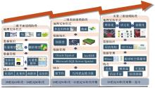
Fig. 1
The development and evolution of 3D realistic geospatial scene geographic entity modeling"

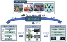
Fig. 2
Overall technical framework of 3D realistic geospatial scene geographic entity modeling"
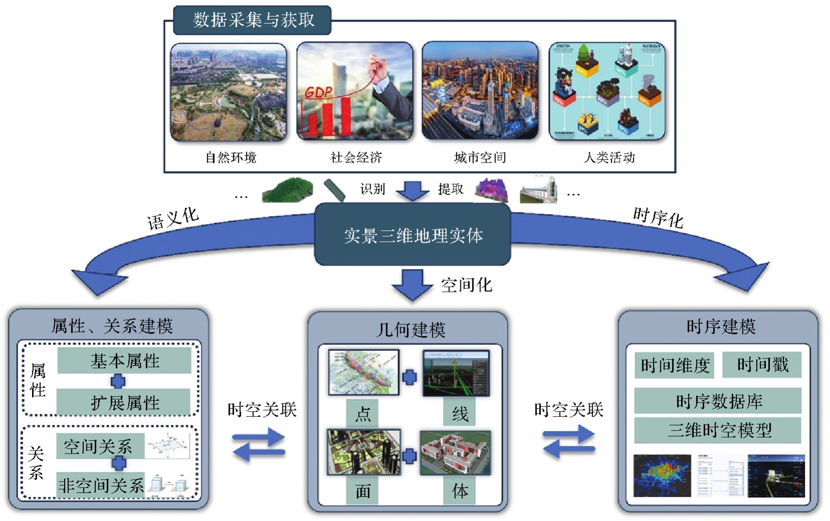
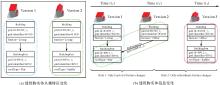
Fig. 3
Temporal management applications based on geographic entities"

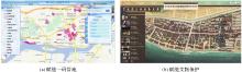
Fig. 4
Spatio-temporal association applications based on geographic entities"

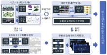
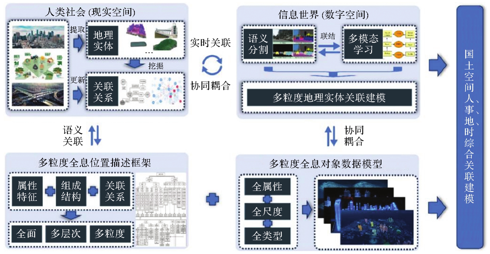
Fig. 5
Multi-granularity panoramic association modeling"
| [1] | 朱庆. 三维GIS及其在智慧城市中的应用[J]. 地球信息科学学报, 2014, 16(2): 151-157. |
| ZHU Qing. Full three-dimensional GIS and its key roles in smart city[J]. Journal of Geo-information Science, 2014, 16(2): 151-157. | |
| [2] | 王明爽, 卢廷军. 面向智慧城市的数字孪生实景三维建模方法研究[J]. 测绘与空间地理信息, 2024, 47(8): 89-92, 96. |
| WANG Mingshuang, LU Tingjun. Research on realistic 3D modelling method of digital twin oriented smart city construction[J]. Geomatics & Spatial Information Technology, 2024, 47(8): 89-92, 96. | |
| [3] | 张周平, 黄嫚, 张春奎, 等. 实景三维地理实体数据建设关键技术研究与实践[J]. 测绘科学, 2024, 49(6): 161-168. |
| ZHANG Zhouping, HUANG Man, ZHANG Chunkui, et al. Research and practice on the construction for construction of 3D real scene geo-entity data[J]. Science of Surveying and Mapping, 2024, 49(6): 161-168. | |
| [4] | 陈军, 刘建军, 田海波. 实景三维中国建设的基本定位与技术路径[J]. 武汉大学学报(信息科学版), 2022, 47(10): 1568-1575. |
| CHEN Jun, LIU Jianjun, TIAN Haibo. Basic directions and technological path for building 3D realistic geospatial scene in China[J]. Geomatics and Information Science of Wuhan University, 2022, 47(10): 1568-1575. | |
| [5] |
朱庆, 张利国, 丁雨淋, 等. 从实景三维建模到数字孪生建模[J]. 测绘学报, 2022, 51(6): 1040-1049. DOI:.
doi: 10.11947/j.AGCS.2022.20210640 |
|
ZHU Qing, ZHANG Liguo, DING Yulin, et al. From real 3D modeling to digital twin modeling[J]. Acta Geodaetica et Cartographica Sinica, 2022, 51(6): 1040-1049. DOI:.
doi: 10.11947/j.AGCS.2022.20210640 |
|
| [6] | 龚健雅, 夏宗国. 矢量与栅格集成的三维数据模型[J]. 武汉测绘科技大学学报, 1997, 22(1): 7-15. |
| GONG Jianya, XIA Zongguo. An integrated data model in three dimensional GIS[J]. Journal of Wuhan Technical University of Surveying and Mapping, 1997, 22(1): 7-15. | |
| [7] | KAVOURAS M, MASRY S E. An information system for geosciences: design considerations[EB/OL]. [2024-05-20]. https://cartogis.org/docs/proceedings/archive/auto-carto-8/pdf/an-information-system-for-geosciences-design-considerations.pdf. |
| [8] | COUCLELIS H. People manipulate objects (but cultivate fields): beyond the raster-vector debate in GIS[C]//Proceedings of 1992 Theories and Methods of Spatio-temporal Reasoning in Geographic Space. Berlin: Springer, 1992: 65-77. |
| [9] | 边馥苓, 傅仲良, 胡自锋. 面向目标的栅格矢量一体化三维数据模型[J]. 武汉测绘科技大学学报, 2000, 25(4): 294-298. |
| BIAN Fuling, FU Zhongliang, HU Zifeng. An object-oriented integrative 3D data model[J]. Journal of Wuhan Technical University of Surveying and Mapping, 2000, 25(4): 294-298. | |
| [10] | SEQUEIRA V, GONCALVES J G M. 3D reality modelling: photo-realistic 3D models of real world scenes[C]//Proceedings of 2002 International Symposium on 3D Data Processing Visualization and Transmission. Padua: IEEE, 2022: 776-783. |
| [11] | MAO Bo, BAN Yifang, LAUMERT B. Dynamic online 3D visualization framework for real-time energy simulation based on 3D tiles[J]. ISPRS International Journal of Geo-Information, 2020, 9(3): 166. |
| [12] | LE H V, TAKASU A. G-HBase: a high performance geographical database based on HBase[J]. IEICE Transactions on Information and Systems, 2018, E101-D(4): 1053-1065. |
| [13] | 傅伯杰. 地理学:从知识、科学到决策[J]. 地理学报, 2017, 72(11): 1923-1932. |
| FU Bojie. Geography: from knowledge, science to decision making support[J]. Acta Geographica Sinica, 2017, 72(11): 1923-1932. | |
| [14] | 王卷乐, 李凯, 严欣荣, 等. 地理要素分类机器学习方法发展与前景[J]. 遥感学报, 2023, 27(8): 1757-1768. |
| WANG Juanle, LI Kai, YAN Xinrong, et al. Development and prospects of machine learning methods in geographic elements classification[J]. National Remote Sensing Bulletin, 2023, 27(8): 1757-1768. | |
| [15] | YUAN M. Representing complex geographic phenomena in GIS[J]. Cartography and Geographic Information Science, 2001, 28(2): 83-96. |
| [16] | 闾国年, 俞肇元, 周良辰, 等. 地理实体分类与编码体系的构建[J]. 现代测绘, 2019, 42(1): 1-6. |
| LÜ Guonian, YU Zhaoyuan, ZHOU Liangchen, et al. Construction of geographical entity classification and coding system[J]. Modern Surveying and Mapping, 2019, 42(1): 1-6. | |
| [17] | 燕琴, 翟亮, 刘坡. 实景三维中国建设关键技术研究综述[J]. 测绘科学, 2023, 48(7): 1-9. |
| YAN Qin, ZHAI Liang, LIU Po. Review on the key technologies of 3D real scene construction in China[J]. Science of Surveying and Mapping, 2023, 48(7): 1-9. | |
| [18] | 陈旻, 闾国年, 周成虎, 等. 面向新时代地理学特征研究的地理建模与模拟系统发展及构建思考[J]. 中国科学:地球科学, 2021, 51(10): 1664-1680. |
| CHEN Min, LÜ Guonian, ZHOU Chenghu, et al. Geographic modeling and simulation systems for geographic research in the new era: some thoughts on their development and construction[J]. Science China (Earth Sciences), 2021, 64(8): 1207-1223. | |
| [19] | 舒振宇, 杨思鹏, 辛士庆, 等. 基于分层学习的三维模型兴趣点提取算法[J]. 计算机辅助设计与图形学学报, 2020, 32(2): 222-232. |
| SHU Zhenyu, YANG Sipeng, XIN Shiqing, et al. Detecting 3D points of interest using hierarchical training strategy[J]. Journal of Computer-Aided Design & Computer Graphics, 2020, 32(2): 222-232. | |
| [20] | 何慧, 杜国政. 基于车载激光扫描点云数据的道路边线提取方法研究[J]. 测绘与空间地理信息, 2024, 47(7): 207-210, 214. |
| HE Hui, DU Guozheng. Research on road edge extraction method based on vehicle-borne laser scanning point cloud data[J]. Geomatics & Spatial Information Technology, 2024, 47(7): 207-210, 214. | |
| [21] | SHEN Tao, ZHANG Huabin, HUO Liang, et al. Spatial data fusion model design and research for an underground pipeline in urban environment scene modeling[J]. Applied Sciences, 2024, 14(15): 6760. |
| [22] | 宋素素. 无人机遥感城市地块高精度DEM建模方法研究[D]. 淮南: 安徽理工大学, 2021. |
| SONG Susu. Research on modeling method of high-precision DEM for urban plots by UAV remote sensing[D]. Huainan: Anhui University of Science & Technology, 2021. | |
| [23] | 杨永林, 刘东, 刘洋, 等. 实景三维建模中的建筑物mesh模型立面修整[J]. 测绘通报, 2023(10): 154-157. |
| YANG Yonglin, LIU Dong, LIU Yang, et al. Building mesh model facade trimming in real 3D modeling[J]. Bulletin of Surveying and Mapping, 2023(10): 154-157. | |
| [24] | 史与正, 陈梦华, 黄煜, 等. 实景三维模型的建筑物单体模型框架搭建[J]. 测绘通报, 2023(6): 161-166. |
| SHI Yuzheng, CHEN Menghua, HUANG Yu, et al. The construction of building monomer model framework based on real scene 3D model[J]. Bulletin of Surveying and Mapping, 2023(6): 161-166. | |
| [25] | YANG Yongquan, KONG Dehui, CAO Min, et al. GEUKE: a geographic entities uniformly explicit knowledge embedding model[J]. Transactions in GIS, 2024, 28(5): 1313-1325. |
| [26] | GAO Xueyao, LI Kaipeng, ZHANG Chunxiang, et al. 3D model classification based on Bayesian classifier with AdaBoost[J]. Discrete Dynamics in Nature and Society, 2021, 2021: 2154762. |
| [27] | MA Rui, CHEN Jiayu, YANG Chendi, et al. OSMsc: a framework for semantic 3D city modeling using OpenStreetMap[J]. International Journal of Geographical Information Science, 2024, 38(1): 1-26. |
| [28] | WENG Zhengping, HE Zhenwen, WU Chonglong. Fast modeling method for three-dimensional entity of mass underground spatial data[C]//Proceedings of 2010 International Conference on Geoinformatics. Beijing: IEEE, 2010: 1-4. |
| [29] | LEE J, KWAN M P. A combinatorial data model for representing topological relations among 3D geographical features in micro-spatial environments[J]. International Journal of Geographical Information Science, 2005, 19(10): 1039-1056. |
| [30] | 刘晰, 耿丽丽, 刘建川, 等. 基础地理实体关系设计与试验[J]. 测绘科学, 2023, 48(3): 30-39. |
| LIU Xi, GENG Lili, LIU Jianchuan, et al. Design and experiment of fundamental geo-entity relationship[J]. Science of Surveying and Mapping, 2023, 48(3): 30-39. | |
| [31] | GONG Qi, GUO Ning, XIONG Wei, et al. A spatio-temporal data model of geographic entities[C]//Proceedings of 2018 International Conference on Geoinformatics. Kunming: IEEE, 2018: 1-6. |
| [32] | ZHANG Jincheng, WILLIS A R. Bridging formal shape models and deep learning: a novel fusion for understanding 3D objects[J]. Sensors, 2024, 24(12): 3874. |
| [33] | CHAU V T N, CHITTAYASOTHORN S. A conceptual schema-based temporal meta database schemas generation technique for 3D objects[J]. Knowledge and Information Systems, 2010, 24(1): 113-147. |
| [34] | JAILLOT V, SERVIGNE S, GESQUIÈRE G. Delivering time-evolving 3D city models for web visualization[J]. International Journal of Geographical Information Science, 2020, 34(10): 2030-2052. |
| [35] | ZHANG Kai, CHEN Mengyuan, FENG Shaokai, et al. Effects of coal mining disturbance on spatial and temporal distribution of soil water content in Northwest China: based on 3D EBK model[J]. Hydrological Processes, 2024, 38(9): e15277. |
| [36] | WANG Aili, WANG Shunsheng, LIU Tengfei, et al. Spatial-temporal evolution analysis and deep learning inversion of water- carbon-three-dimensional ecological footprint of urban agglomeration in the middle reaches of the Yangtze River[J]. Desalination and Water Treatment, 2023, 290: 193-200. |
| [37] | QIU Yuxuan, XU Suchen, XIAO Wu, et al. Urban concrete forest: China's 3D urban expansion over the last three decades[J]. Journal of Urban Planning and Development, 2024, 150(1): 04024003. |
| [38] | HE Hongmei, ZHOU Di, SHENG Min, et al. Hierarchical cross-domain satellite resource management: an intelligent collaboration perspective[J]. IEEE Transactions on Communications, 2023, 71(4): 2201-2215. |
| [39] | LI Yuejin, CHEN Shengpeng, HWANG K, et al. Spatio-temporal data fusion techniques for modeling digital twin city[J/OL]. Geo-spatial Information Science, 2024: 1-24[2024-05-20]. https://doi.org/10.1080/10095020.2024.2350175. |
| [40] | 何开全, 彭文, 陈贵花, 等. 二三维海陆一体综合信息平台设计与实现[J]. 测绘地理信息, 2022, 47(1): 47-50. |
| HE Kaiquan, PENG Wen, CHEN Guihua, et al. Design and implementation of 2D and 3D sea-land integrated information platform[J]. Journal of Geomatics, 2022, 47(1): 47-50. | |
| [41] | 马茂鑫, 张健钦, 崔晓琛, 等. 一种面向道路养护的多粒度时空对象模型研究[J]. 测绘科学, 2023, 48(10): 206-215. |
| MA Maoxin, ZHANG Jianqin, CUI Xiaochen, et al. Research on multi-granularity spatio-temporal object model for road maintenance[J]. Science of Surveying and Mapping, 2023, 48(10): 206-215. | |
| [42] | GAUTIER C, DELANOY J, GESQUIERE G. Representation of urban geometry evolution through space-time cube[C]//Proceedings of 2023 International Conference Information Visualisation. Tampere: IEEE, 2023: 414-419. |
| [43] | STANCZAK A, MOORE A B. An artistic perspective on individual space-time flows[J]. International Journal of Cartography, 2024, 10(2): 229-246. |
| [1] | Chenming YE, Zhizhong KANG, Jinhao CAI, Bingzheng ZUO, Shuai SHAO, Yan LI. A morphology-guided real-scene 3D modeling method of lunar geo-entities [J]. Acta Geodaetica et Cartographica Sinica, 2026, 55(3): 525-535. |
| [2] | Zhuang SUN, Po LIU, Liang ZHAI, Yu HE, Zutao ZHANG. A self-supervised matching method for polygonal geographic entity based on a three-branch attention network [J]. Acta Geodaetica et Cartographica Sinica, 2026, 55(1): 169-180. |
| [3] | WANG Dali, TONG Xiaochong, MENG Li, LEI Yi, GUO Congzhou, ZHANG Youwei. Structural modeling of spatial information in texts and semantic localization [J]. Acta Geodaetica et Cartographica Sinica, 2023, 52(8): 1398-1410. |
| [4] | LING Zhaoyang, LI Rui, WU Huayi, LI Jiang, GUI Zhipeng. Semantic-driven construction of geographic entity association network and knowledge service [J]. Acta Geodaetica et Cartographica Sinica, 2023, 52(3): 478-489. |
| Viewed | ||||||
|
Full text |
|
|||||
|
Abstract |
|
|||||