

Acta Geodaetica et Cartographica Sinica ›› 2024, Vol. 53 ›› Issue (12): 2338-2348.doi: 10.11947/j.AGCS.2024.20230549
• Marine Survey • Previous Articles Next Articles
Tian XIE1( ), Jian DONG1(), Lulu TANG1, Mengkai MA1, Mingyang ZHANG2, Zikang SONG3, Dong WANG1
Received:2023-12-13
Online:2025-01-06
Published:2025-11-06
Contact:
Jian DONG
E-mail:xietian0229@163.com;navydj@163.com
About author:XIE Tian (2000—), male, postgraduate, majors in geographic information methods and maritime delimitation. E-mail: xietian0229@163.com
Supported by:CLC Number:
Tian XIE, Jian DONG, Lulu TANG, Mengkai MA, Mingyang ZHANG, Zikang SONG, Dong WANG. Scale-adaptive Mercator projection plane geodesic precise plotting algorithm[J]. Acta Geodaetica et Cartographica Sinica, 2024, 53(12): 2338-2348.
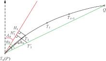
Fig. 1
The elements for plotting a geodesic line on northern hemisphere on the projection plane"
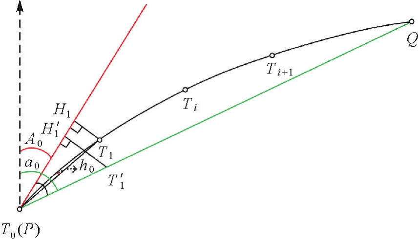

Fig. 2
Projection curve of a geodesic line crossing the equator on the projection plane"
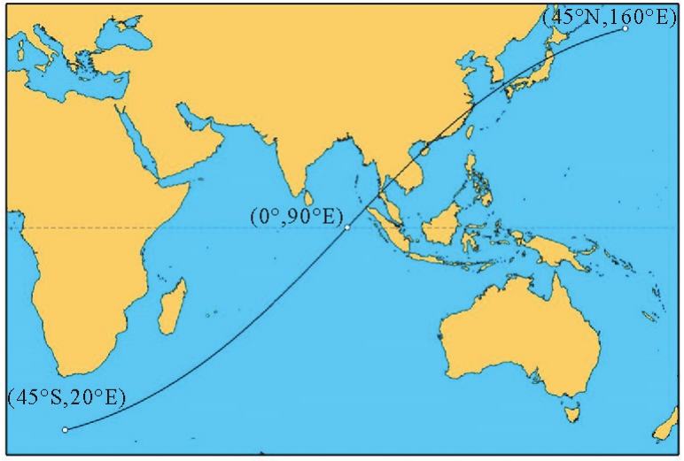

Fig. 3
The elements for plotting a geodesic line crossing the equator on the projection plane"

Fig. 4
Calculating the geodesic equatorial division point"
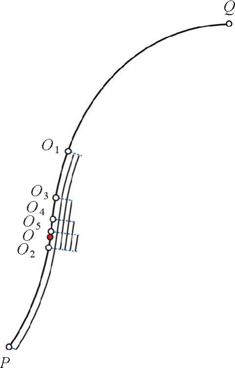

Fig. 5
Apex of the projection curve of a geodesic line on the Mercator projection plane"
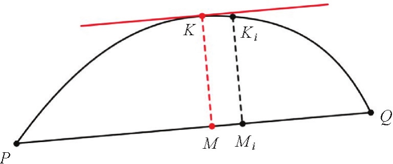

Fig. 6
Rapid convergence of geodesic line projection curve arch height error"
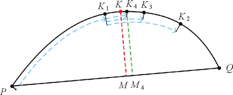

Fig. 7
Criterions for rapid convergence judgment of geodesic arch height guided by precise geodetic azimuth"


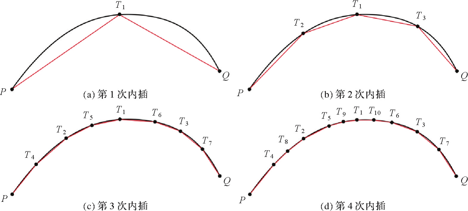
Fig. 8
Calculation results for the efficient iterative interpolation model of the geodesic line"
Tab. 1
Calculation results of algorithm 1 under undivided conditions"
| 算例 | 端点坐标 | 比例尺 | 大地线长度/m | 最大拱高/mm | 最小拱高/mm | 平均拱高/mm |
|---|---|---|---|---|---|---|
| 算例1 | 41°23'59.56″N,70°18'52.37″E | 1∶200 000 | 8 000 000.09 | 2.16 | 1.54×10⁻⁹ | 1.79×10⁻⁴ |
| 20°30'15.20″S,30°18'25.14″E | ||||||
| 算例2 | 08°22'28.12″N,57°19'25.13″E | 1∶10 000 | 1 999 935.32 | 1.06×10⁻¹ | 1.63×10⁻⁸ | 5.15×10⁻⁵ |
| 04°33'05.38″S,69°55'23.13″E | ||||||
| 算例3 | 01°07'08.25″N,115°51'48.11″E | 1∶2000 | 700 000.05 | 4.12×10⁻¹ | 7.78×10⁻⁹ | 3.34×10⁻⁴ |
| 02°00'28.19″S,110°23'41.57″E |
Tab. 2
Calculation results of algorithm 1 and algorithm 2 after division, and calculation results of algorithm 3"
| 算例 | 算法1 | 算法2 | 算法3 | ||||||
|---|---|---|---|---|---|---|---|---|---|
| 最大拱高 | 最小拱高 | 平均拱高 | 最大拱高 | 最小拱高 | 平均拱高 | 最大拱高 | 最小拱高 | 平均拱高 | |
| 算例1 | 2.49×10⁻² | 3.64×10⁻⁶ | 4.75×10⁻⁵ | 9.73×10⁻² | 2.61×10⁻² | 4.32×10⁻² | 6.32×10⁻⁵ | 1.08×10⁻⁹ | 1.77×10⁻⁵ |
| 算例2 | 2.20×10⁻² | 6.52×10⁻⁶ | 9.66×10⁻⁵ | 9.25×10⁻² | 2.60×10⁻² | 4.53×10⁻² | 1.77×10⁻⁴ | 6.15×10⁻⁹ | 7.35×10⁻⁵ |
| 算例3 | 2.89×10⁻² | 2.56×10⁻⁵ | 3.49×10⁻⁴ | 9.13×10⁻² | 2.39×10⁻² | 4.85×10⁻² | 2.56×10⁻⁴ | 1.68×10⁻⁷ | 1.08×10⁻⁴ |

Fig. 9
Plotting results of algorithm 1, algorithm 2 and algorithm 3"

Tab. 3
The interpolation points number and algorithm efficiency of algorithm 1 and algorithm 2 at a 1∶2000 scale"
| 方位角/(°) | 算法1 | 算法2 | ||||||
|---|---|---|---|---|---|---|---|---|
| 100 km | 1000 km | 100 km | 1000 km | |||||
| 内插点数 | 时间/ms | 内插点数 | 时间/ms | 内插点数 | 时间/ms | 内插点数 | 时间/ms | |
| 30 | 34 654 | 1 584.65 | 568 238 | 25 915.61 | 33 | 10.69 | 257 | 48.57 |
| 60 | 31 730 | 1 436.19 | 447 537 | 20 472.97 | 33 | 3.29 | 257 | 39.59 |
| 90 | 820 | 38.43 | 81 316 | 3 805.85 | 33 | 2.10 | 257 | 27.50 |
| 120 | 28 856 | 1 336.32 | 164 119 | 7 619.46 | 33 | 3.29 | 257 | 31.90 |
| 150 | 30 551 | 1 420.54 | 153 837 | 7 175.61 | 33 | 3.16 | 257 | 28.45 |
| 180 | 2 | 0.45 | 2 | 0.17 | 2 | 0.92 | 2 | 1.23 |
| 210 | 30 551 | 1 449.62 | 153 837 | 7 331.62 | 33 | 2.98 | 257 | 27.25 |
| 240 | 28 856 | 1 364.12 | 164 119 | 7 788.16 | 33 | 3.18 | 257 | 27.99 |
| 270 | 820 | 39.05 | 81 316 | 3 889.28 | 33 | 2.03 | 257 | 23.12 |
| 300 | 31 730 | 1 513.91 | 447 537 | 21 534.94 | 33 | 3.71 | 257 | 29.27 |
| 330 | 34 654 | 1 661.31 | 568 238 | 27 204.77 | 33 | 3.16 | 257 | 27.94 |
| 360 | 2 | 0.16 | 2 | 0.15 | 2 | 0.34 | 2 | 0.03 |
| 平均值 | 21 102 | 987.06 | 235 842 | 11 061.55 | 28 | 3.24 | 215 | 26.07 |
Tab. 4
The interpolation points number and algorithm efficiency of algorithm 1 and algorithm 2 at a 1∶20 000 scale"
| 方位角/(°) | 算法1 | 算法2 | ||||||
|---|---|---|---|---|---|---|---|---|
| 100 km | 1000 km | 100 km | 1000 km | |||||
| 内插点数 | 时间/ms | 内插点数 | 时间/ms | 内插点数 | 时间/ms | 内插点数 | 时间/ms | |
| 30 | 3467 | 177.34 | 56 825 | 2 608.17 | 9 | 8.64 | 67 | 19.23 |
| 60 | 3175 | 144.99 | 44 761 | 2 055.19 | 9 | 0.95 | 129 | 13.20 |
| 90 | 78 | 3.72 | 8133 | 380.23 | 9 | 0.45 | 129 | 11.55 |
| 120 | 2887 | 134.51 | 16 413 | 764.49 | 9 | 0.98 | 123 | 13.11 |
| 150 | 3056 | 142.11 | 15 385 | 717.27 | 9 | 0.94 | 65 | 9.43 |
| 180 | 2 | 0.13 | 2 | 0.16 | 2 | 0.70 | 2 | 1.08 |
| 210 | 3056 | 145.26 | 15 385 | 731.75 | 9 | 0.90 | 65 | 9.07 |
| 240 | 2887 | 137.61 | 16 413 | 780.43 | 9 | 0.95 | 123 | 9.32 |
| 270 | 78 | 3.79 | 8133 | 389.36 | 9 | 0.44 | 129 | 6.16 |
| 300 | 3175 | 152.35 | 44 761 | 2 155.62 | 9 | 1.03 | 129 | 9.46 |
| 330 | 3467 | 166.49 | 56 825 | 2 726.66 | 9 | 0.95 | 67 | 9.23 |
| 360 | 2 | 0.14 | 2 | 0.16 | 2 | 0.32 | 2 | 0.03 |
| 平均值 | 2111 | 100.70 | 23 587 | 1 109.12 | 8 | 1.44 | 86 | 9.24 |
Tab. 5
The interpolation points number and algorithm efficiency of algorithm 1 and algorithm 2 at a 1∶200 000 scale"
| 方位角/(°) | 算法1 | 算法2 | ||||||
|---|---|---|---|---|---|---|---|---|
| 100 km | 1000 km | 100 km | 1000 km | |||||
| 内插点数 | 时间/ms | 内插点数 | 时间/ms | 内插点数 | 时间/ms | 内插点数 | 时间/ms | |
| 30 | 348 | 27.24 | 5684 | 267.56 | 3 | 8.43 | 33 | 12.17 |
| 60 | 319 | 22.99 | 4478 | 205.52 | 5 | 0.36 | 33 | 4.75 |
| 90 | 11 | 0.55 | 811 | 37.98 | 5 | 0.22 | 33 | 3.71 |
| 120 | 290 | 13.49 | 1642 | 76.41 | 5 | 0.37 | 33 | 4.73 |
| 150 | 307 | 14.31 | 1540 | 71.57 | 3 | 0.24 | 17 | 3.26 |
| 180 | 2 | 0.12 | 2 | 0.39 | 2 | 0.77 | 2 | 1.09 |
| 210 | 307 | 14.59 | 1540 | 73.02 | 3 | 0.23 | 17 | 3.12 |
| 240 | 290 | 13.80 | 1642 | 78.08 | 5 | 0.36 | 33 | 4.10 |
| 270 | 11 | 0.58 | 811 | 38.82 | 5 | 0.22 | 33 | 2.78 |
| 300 | 319 | 15.32 | 4478 | 215.12 | 5 | 0.37 | 33 | 4.18 |
| 330 | 348 | 16.77 | 5684 | 271.92 | 3 | 0.25 | 33 | 3.40 |
| 360 | 2 | 0.12 | 2 | 0.12 | 2 | 0.09 | 2 | 0.03 |
| 平均值 | 213 | 11.66 | 2360 | 111.38 | 4 | 0.99 | 25 | 3.94 |
Tab. 6
The interpolation points number and algorithm efficiency for the equidistant geodesic line plotting algorithm (algorithm 3)"
| 方位角/(°) | 100 km | 1000 km | ||
|---|---|---|---|---|
| 内插点数 | 时间/ms | 内插点数 | 时间/ms | |
| 30 | 101 | 490 | 1001 | 490 |
| 60 | 101 | 470 | 1001 | 490 |
| 90 | 101 | 650 | 1001 | 500 |
| 120 | 101 | 680 | 1001 | 580 |
| 150 | 101 | 480 | 1001 | 490 |
| 180 | 101 | 490 | 1001 | 510 |
| 210 | 101 | 520 | 1001 | 490 |
| 240 | 101 | 490 | 1001 | 790 |
| 270 | 101 | 530 | 1001 | 490 |
| 300 | 101 | 500 | 1001 | 480 |
| 330 | 101 | 570 | 1001 | 520 |
| 360 | 101 | 500 | 1001 | 510 |
| 平均值 | 101 | 531 | 1001 | 528 |
| [1] |
李松林, 陈成, 边少锋, 等. 常用海图投影平面上大椭圆航线的表象与曲率分析[J]. 测绘学报, 2019, 48(10): 1331-1338. DOI:.
doi: 10.11947/J.AGCS.2019.20180348 |
|
LI Songlin, CHEN Cheng, BIAN Shaofeng, et al. Representation and curvature analysis of great ellipse on common chart projection plane[J]. Acta Geodaetica et Cartographica Sinica, 2019, 48(10): 1331-1338. DOI:.
doi: 10.11947/J.AGCS.2019.20180348 |
|
| [2] | CHANG Sisi, JI Bing, HU Qiongfang, et al. Two algorithms of geodesic line length calculation considering elevation in eLoran systems[J]. IET Radar, Sonar & Navigation, 2023, 17(10): 1469-1478. |
| [3] | PATRIKALAKIS N M, BARDIS L. Offsets of curves on rational B-spline surfaces[J]. Engineering with Computers, 1989, 5(1): 39-46. |
| [4] | WEINTRIT A, KOPACZ P. A novel approach to loxodrome (rhumb line), orthodrome (great circle) and geodesic line in ECDIS and navigation in general[M]//Methods and algorithms in navigation. Boca Raton: CRC Press, 2011: 123-132. |
| [5] | CHENG Peng, MIAO Chunyan, LIU Yongjin, et al. Solving the initial value problem of discrete geodesics[J]. Computer-Aided Design, 2016, 70: 144-152. |
| [6] | RAVI KUMAR G V V, SRINIVASAN P, DEVARAJA H, et al. Geodesic curve computations on surfaces[J]. Computer Aided Geometric Design, 2003, 20(2): 119-133. |
| [7] | 彭认灿, 许坚, 沈文周. 椭球面上实施海域精确划界的几个关键问题[J]. 测绘学院学报, 2001, 18(3): 210-212. |
| PENG Rencan, XU Jian, SHEN Wenzhou. The solutions to some key problems of accurately delimitating sea area boundary on the ellipsoid[J]. Journal of Institute of Survey and Mapping, 2001, 18(3): 210-212. | |
| [8] | 张建辉, 张学峰, 肖利, 等. 等距离海洋划界模型研究[J]. 海洋湖沼通报, 2022, 44(4): 1-9. |
| ZHANG Jianhui, ZHANG Xuefeng, XIAO Li, et al. Research on equidistant maritime delimitation model[J]. Transactions of Oceanology and Limnology, 2022, 44(4): 1-9. | |
| [9] | 梁德清, 许坚, 彭认灿. 大地线克莱劳方程在大地线绘制中的应用[J]. 海洋测绘, 2001, 21(2): 20-23. |
| LIANG Deqing, XU Jian, PENG Rencan. Geodetic line Clausius equation in the plotting of geodetic lines[J]. Hydrographic Surveying and Charting, 2001, 21(2): 20-23. | |
| [10] | BASELGA S, OLSEN M J. Approximations, errors, and misconceptions in the use of map projections[J/OL]. Mathematical Problems in Engineering, 2021: 1-12[2023-08-01]. https://doi.org/10.1155/2021/1094602. |
| [11] | THOMAS C M, FEATHERSTONE W E. Validation of Vincenty's formulas for the geodesic using a new fourth-order extension of Kivioja's formula[J]. Journal of Surveying Engineering, 2005, 131(1): 20-26. |
| [12] | VINCENTY T. Direct and inverse solutions of geodesics on the ellipsoid with application of nested equations[J]. Survey Review, 1975, 23(176): 88-93. |
| [13] | TSENG W K, TSAI K C, LIOU C, et al. Algorithms for the generalized inverse solution and direct solution: using an algebra computer-based system to obtain meridian arc length[J]. Journal of Marine Science and Technology, 2023, 31(2): 185-192. |
| [14] | 何菊, 胡鹏, 胡海. 一种适用任意距离的大地主题解算方法的研究和试验[J]. 测绘科学, 2006, 31(2): 29-31. |
| HE Ju, HU Peng, HU Hai. Investigation and experiment of algorithm fitting arbitrary distance[J]. Science of Surveying and Mapping, 2006, 31(2): 29-31. | |
| [15] | 丁士俊, 杨艳梅, 史俊波, 等. 大地主题解算几种不同算法在计算中应注意的问题[J]. 黑龙江工程学院学报(自然科学版), 2013, 27(3): 1-5. |
| DING Shijun, YANG Yanmei, SHI Junbo, et al. Some issues concerning several different algorithms against geodetic problems in the calculation[J]. Journal of Heilongjiang Institute of Technology, 2013, 27(3): 1-5. | |
| [16] | 纪兵, 边少锋. 大地主题问题的非迭代新解[J]. 测绘学报, 2007, 36(3): 269-273. |
| JI Bing, BIAN Shaofeng. The new non-iterative solution to the geodetic problem[J]. Acta Geodaetica et Cartographica Sinica, 2007, 36(3): 269-273. | |
| [17] | 国家市场监督管理总局, 国家标准化管理委员会. 中国航海图编绘规范:GB 12320—2022[S]. 北京: 中国标准出版社, 2022. |
| State Administration for Market Regulation, Standardization Administration of the People's Republic of China. Compilation specifications for Chinese nautical charts: GB 12320—2022[S]. Beijing: Standards Press of China, 2022. | |
| [18] | 唐红涛, 王微, 杨永崇, 等. 椭球面上绘制大地线的算法[J]. 测绘科学, 2015, 40(4): 7-10. |
| TANG Hongtao, WANG Wei, YANG Yongchong, et al. An algorithm of expressing geodesic on the ellipsoid surface[J]. Science of Surveying and Mapping, 2015, 40(4): 7-10. | |
| [19] | HOTZ I, HAGEN H. Visualizing geodesics[C]//Proceedings of 2000 Visualization. Los Alamitos: IEEE Computer Society, 2000: 311-318. |
| [20] | 李彬彬, 彭认灿, 董箭, 等. 绝对精度阈值约束的大地线内插算法[J]. 海洋测绘, 2019, 39(4): 31-35. |
| LI Binbin, PENG Rencan, DONG Jian, et al. Geodetic interpolation algorithm with absolute precision threshold constraints[J]. Hydrographic Surveying and Charting, 2019, 39(4): 31-35. | |
| [21] | 董箭, 李彬彬, 彭认灿, 等. 顾及拱高误差的墨卡托大地线快速展绘算法[J]. 测绘科学, 2020, 45(9): 43-51. |
| DONG Jian, LI Binbin, PENG Rencan, et al. Rapid plotting algorithm for the Mercator geodetic line with regard to the arch height error[J]. Science of Surveying and Mapping, 2020, 45(9): 43-51. | |
| [22] | 华棠, 丁佳波, 边少锋, 等. 地图海图投影学[M]. 西安: 西安地图出版社, 2018. |
| HUA Tang, DING Jiabo, BIAN Shaofeng, et al. Map and chart projection science[M]. Xi'an: Xi'an Map Publishing House, 2018. | |
| [23] | 屈婉玲. 算法设计与分析[M]. 北京: 清华大学出版社, 2011. |
| QU Wanling. Design and analysis of algorithms[M]. Beijing: Tsinghua University Press, 2011. | |
| [24] | DOUGLAS D H, PEUCKER T. Algorithms for the reduction of the number of points required to represent a digitized line or its caricature[J]. The Canadian Cartographer, 1973, 10(2): 112-122. |
| [1] | DOU Shiqing, ZHAO Xuesheng, LIU Chengjun, LIN Yawen, ZHAO Yanqin. The Three Dimensional Douglas-Peucker Algorithm for Generalization between River Network Line Element and DEM [J]. Acta Geodaetica et Cartographica Sinica, 2016, 45(4): 450-457. |
| Viewed | ||||||
|
Full text |
|
|||||
|
Abstract |
|
|||||