

Acta Geodaetica et Cartographica Sinica ›› 2025, Vol. 54 ›› Issue (10): 1852-1862.doi: 10.11947/j.AGCS.2025.20250200
• Photogrammetry and Remote Sensing • Previous Articles Next Articles
Xin XIONG1,2( ), Guowang JIN1,2(), Ruibing CUI1,3, Shuo LI2, He YANG4
Received:2025-05-12
Revised:2025-07-28
Online:2025-11-14
Published:2025-11-14
Contact:
Guowang JIN
E-mail:xiongxinhbhh@163.com;guowang_jin@163.com
About author:XIONG Xin (1991—), male, PhD, lecturer, majors in microwave remote sensing. E-mail: xiongxinhbhh@163.com
Supported by:CLC Number:
Xin XIONG, Guowang JIN, Ruibing CUI, Shuo LI, He YANG. Fast matching method of optical and SAR images using rank self-similarity features[J]. Acta Geodaetica et Cartographica Sinica, 2025, 54(10): 1852-1862.

Fig. 1
Subimages construction"

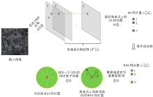
Fig. 2
Process of RSS feature generation"


Fig. 3
3D PC fast matching"


Fig. 4
Six example optical and SAR image pairs"

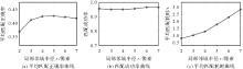
Fig. 5
Matching results with varying r"

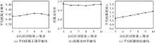
Fig. 6
Matching results with varying o"

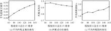
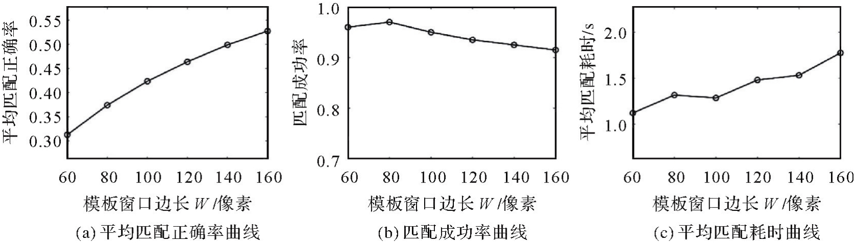
Fig. 7
Matching results with varying W"
Tab. 1
Matching results of five methods"
| 方法 | 平均匹配正确率 | 匹配成功率 | 平均均方根误差/像素 | 平均匹配耗时/s |
|---|---|---|---|---|
| DLSS | 0.314 | 0.950 | 1.939 | 43.064 |
| DRLSS | 0.375 | 0.960 | 1.928 | 60.740 |
| HOPC | 0.376 | 0.950 | 1.906 | 35.675 |
| WED-HOPC | 0.363 | 0.960 | 1.960 | 42.104 |
| CFOG | 0.260 | 0.905 | 1.943 | 1.494 |
| FRSS | 0.423 | 0.950 | 1.863 | 1.323 |

Fig. 8
Matching results of five methods"


Fig. 9
Correct matches of FRSS for six example image pairs"

Tab. 2
Main parameters of TH-2 SAR images"
| 参数类型 | 廊坊地区 | 登封地区 |
|---|---|---|
| 获取时间 | 2020-05-05 | 2019-10-14 |
| 中心入射角/(°) | 37.78 | 40.03 |
| 方位向采样间隔/m | 2.050 633 | 1.879 528 |
| 距离向采样间隔/m | 0.936 851 | 0.936 851 |
| 方位向像元数/像素 | 19 902 | 19 414 |
| 距离向像元数/像素 | 21 910 | 23 014 |
| 近距延迟/m | 665 688.570 473 | 688 592.988 933 |
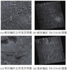
Fig. 10
Public optical images and TH-2 SAR images"


Fig. 11
Matching results of image pairs in Langfang area"


Fig. 12
Matching results of image pairs in Dengfeng area"

Tab. 3
Matching results of public optical images and TH-2 SAR images"
| 试验区域 | 匹配点数量 | 匹配耗时/s |
|---|---|---|
| 廊坊地区 | 351 | 66.068 |
| 登封地区 | 348 | 65.234 |
| [1] | 靳国旺, 张红敏, 徐青. 雷达摄影测量[M]. 北京: 测绘出版社, 2015. |
| JIN Guowang, ZHANG Hongmin, XU Qing. Radargrammetry[M]. Beijing: Surveying and Mapping Press, 2015. | |
| [2] | 张绍明, 陈鹰, 林怡. SAR图像与光学图像多子区鲁棒匹配算法[J]. 同济大学学报(自然科学版), 2009, 37(1): 121-125, 133. |
| ZHANG Shaoming, CHEN Ying, LIN Yi. Robust algorithm of matching SAR image to optical image using multiple subarea[J]. Journal of Tongji University (Natural Science), 2009, 37(1): 121-125, 133. | |
| [3] | 陈子涵, 王峰, 许宁, 等. 基于改进NSST-PCNN的光学与SAR图像融合去云方法[J]. 遥感技术与应用, 2021, 36(4): 810-819. |
| CHEN Zihan, WANG Feng, XU Ning, et al. Cloud removal by fusing optical and SAR images based on improved PCNN in NSST domain[J]. Remote Sensing Technology and Application, 2021, 36(4): 810-819. | |
| [4] |
田峰, 李虎. 联合星载光学与SAR图像的城市大面积建筑物高度快速提取[J]. 测绘学报, 2017, 46(7): 891-899. DOI: .
doi: 10.11947/j.AGCS.2017.20160573 |
|
TIAN Feng, LI Hu. Fusion of spaceborne optical and SAR images for building height quick extraction in big urban areas[J]. Acta Geodaetica et Cartographica Sinica, 2017, 46(7): 891-899. DOI: .
doi: 10.11947/j.AGCS.2017.20160573 |
|
| [5] |
吴瑞娟. 基于高分SAR与光学影像数据融合的滨海湿地变化监测方法[J]. 测绘学报, 2021, 50(2): 280. DOI: .
doi: 10.11947/j.AGCS.2021.20190504 |
|
WU Ruijuan. Monitoring coastal wetlands changes using fusion of high-resolution SAR and optical images[J]. Acta Geodaetica et Cartographica Sinica, 2021, 50(2): 280. DOI: .
doi: 10.11947/j.AGCS.2021.20190504 |
|
| [6] | 王志豪, 李刚, 蒋骁. 基于光学和SAR遥感图像融合的洪灾区域检测方法[J]. 雷达学报, 2020, 9(3): 539-553. |
| WANG Zhihao, LI Gang, JIANG Xiao. Flooded area detection method based on fusion of optical and SAR remote sensing images[J]. Journal of Radars, 2020, 9(3): 539-553. | |
| [7] |
眭海刚, 刘畅, 干哲, 等. 多模态遥感图像匹配方法综述[J]. 测绘学报, 2022, 51(9): 1848-1861. DOI: .
doi: 10.11947/j.AGCS.2022.20220126 |
|
SUI Haigang, LIU Chang, GAN Zhe, et al. Overview of multi-modal remote sensing image matching methods[J]. Acta Geodaetica et Cartographica Sinica, 2022, 51(9): 1848-1861. DOI: .
doi: 10.11947/j.AGCS.2022.20220126 |
|
| [8] | MA Jiayi, JIANG Xingyu, FAN Aoxiang, et al. Image matching from handcrafted to deep features: a survey[J]. International Journal of Computer Vision, 2021, 129(1): 23-79. |
| [9] |
靳国旺, 熊新, 张红敏, 等. 相同侧视方向异轨SAR图像差异化约束连接点提取[J]. 测绘学报, 2018, 47(1): 91-101. DOI: .
doi: 10.11947/j.AGCS.2018.20170129 |
|
JIN Guowang, XIONG Xin, ZHANG Hongmin, et al. Tie point extraction for SAR images with same side-looking direction from different trajectories based on differential constraints[J]. Acta Geodaetica et Cartographica Sinica, 2018, 47(1): 91-101. DOI: .
doi: 10.11947/j.AGCS.2018.20170129 |
|
| [10] | SURI S, REINARTZ P. Mutual-information-based registration of TerraSAR-X and Ikonos imagery in urban areas[J]. IEEE Transactions on Geoscience and Remote Sensing, 2010, 48(2): 939-949. |
| [11] |
陈敏, 朱庆, 朱军, 等. SAR影像与光学影像的高斯伽玛型边缘强度特征匹配法[J]. 测绘学报, 2016, 45(3): 318-325. DOI: .
doi: 10.11947/j.AGCS.2016.20150084 |
|
CHEN Min, ZHU Qing, ZHU Jun, et al. Feature matching for SAR and optical images based on Gaussian-Gamma shaped edge strength map[J]. Acta Geodaetica et Cartographica Sinica, 2016, 45(3): 318-325. DOI: .
doi: 10.11947/j.AGCS.2016.20150084 |
|
| [12] | YE Yuanxin, BRUZZONE L, SHAN Jie, et al. Fast and robust matching for multimodal remote sensing image registration[J]. IEEE Transactions on Geoscience and Remote Sensing, 2019, 57(11): 9059-9070. |
| [13] | XIANG Yuming, TAO Rongshu, WAN Ling, et al. OS-PC: combining feature representation and 3D phase correlation for subpixel optical and SAR image registration[J]. IEEE Transactions on Geoscience and Remote Sensing, 2020, 58(9): 6451-6466. |
| [14] | YE Yuanxin, SHAN Jie, BRUZZONE L, et al. Robust registration of multimodal remote sensing images based on structural similarity[J]. IEEE Transactions on Geoscience and Remote Sensing, 2017, 55(5): 2941-2958. |
| [15] | FAN Jianwei, WU Yan, LI Ming, et al. SAR and optical image registration using nonlinear diffusion and phase congruency structural descriptor[J]. IEEE Transactions on Geoscience and Remote Sensing, 2018, 56(9): 5368-5379. |
| [16] | XIANG Yuming, TAO Rongshu, WANG Feng, et al. Automatic registration of optical and SAR images via improved phase congruency model[J]. IEEE Journal of Selected Topics in Applied Earth Observations and Remote Sensing, 2020, 13: 5847-5861. |
| [17] | YE Yibin, WANG Qinwei, ZHAO Hong, et al. Fast and robust optical-to-SAR remote sensing image registration using region-aware phase descriptor[J]. IEEE Transactions on Geoscience and Remote Sensing, 2024, 62: 5208512. |
| [18] | 孙明超, 马天翔, 宋悦铭, 等. 基于相位特征的可见光和SAR遥感图像自动配准[J]. 光学 精密工程, 2021, 29(3): 616-627. |
| SUN Mingchao, MA Tianxiang, SONG Yueming, et al. Automatic registration of optical and SAR remote sensing image based on phase feature[J]. Optics and Precision Engineering, 2021, 29(3): 616-627. | |
| [19] | YE Yuanxin, SHEN Li, HAO Ming, et al. Robust optical-to-SAR image matching based on shape properties[J]. IEEE Geoscience and Remote Sensing Letters, 2017, 14(4): 564-568. |
| [20] | XIONG Xin, XU Qing, JIN Guowang, et al. Rank-based local self-similarity descriptor for optical-to-SAR image matching[J]. IEEE Geoscience and Remote Sensing Letters, 2020, 17(10): 1742-1746. |
| [21] | HONG Yameng, LENG Chengcai, ZHANG Xinyue, et al. Max-index based local self-similarity descriptor for robust multi-modal image registration[J]. IEEE Geoscience and Remote Sensing Letters, 2022, 19: 4505805. |
| [22] | XIONG Xin, JIN Guowang, XU Qing, et al. Self-similarity features for multimodal remote sensing image matching[J]. IEEE Journal of Selected Topics in Applied Earth Observations and Remote Sensing, 2021, 14: 12440-12454. |
| [23] | XIONG Xin, JIN Guowang, XU Qing, et al. Robust registration algorithm for optical and SAR images based on adjacent self-similarity feature[J]. IEEE Transactions on Geoscience and Remote Sensing, 2022, 60: 1-17. |
| [24] | ANUTA P E. Spatial registration of multispectral and multitemporal digital imagery using fast Fourier transform techniques[J]. IEEE Transactions on Geoscience Electronics, 1970, 8(4): 353-368. |
| [25] | YU Qiuze, NI Dawen, JIANG Yuxuan, et al. Universal SAR and optical image registration via a novel SIFT framework based on nonlinear diffusion and a polar spatial-frequency descriptor[J]. ISPRS Journal of Photogrammetry and Remote Sensing, 2021, 171: 1-17. |
| [1] | FAN Zhongli, ZHANG Li, WANG Qingdong, LIU Siting, YE Yuanxin. A fast matching method of SAR and optical images using angular weighted orientated gradients [J]. Acta Geodaetica et Cartographica Sinica, 2021, 50(10): 1390-1403. |
| [2] | LI Cailin, WANG Zhiyong, YU Lulu, GUO Baoyun. Geometric registration of close-range optical image and terrestrial laser point cloud constrained by nearest surface [J]. Acta Geodaetica et Cartographica Sinica, 2020, 49(8): 1014-1022. |
| [3] | LI Dongchen, XIANG Wenhao, DANG Qiannan, WU Yan. SAR and optical images registration using uniform distribution and structure description-based ASIFT [J]. Acta Geodaetica et Cartographica Sinica, 2020, 49(12): 1583-1590. |
| [4] | HE Lijia, FENG Guangcai, FENG Zhixiong, GAO Hua. Coseismic displacements of 2016 MW7.8 Kaikoura, New Zealand earthquake, using Sentinel-2 optical images [J]. Acta Geodaetica et Cartographica Sinica, 2019, 48(3): 339-351. |
| [5] | Yun ZHANG. Smart Photogrammetric and Remote Sensing Image Processing for Optical Very High Resolution Images-Examples from the CRC-AGIP Lab at UNB [J]. Acta Geodaetica et Cartographica Sinica, 2018, 47(6): 722-729. |
| [6] | YANG Bo, WANG Mi, PI Yingdong. Block-adjustment without GCPs for Large-scale Regions only Based on the Virtual Control Points [J]. Acta Geodaetica et Cartographica Sinica, 2017, 46(7): 874-881. |
| [7] | WU Shihua, WU Yiquan, ZHOU Jianjiang, MENG Tianliang. SAR River Image Segmentation Based on Reciprocal Gray Entropy and Improved Chan-Vese Model [J]. Acta Geodaetica et Cartographica Sinica, 2015, 44(11): 1255-1262. |
| [8] | LIU Xiaogang LI Yingchun XIAO Yun ZHAI Zhenhe. Study of Optimal Regularization Parameter Determination Method in Downward Continuation of Gravimetric and Geomagnetic Data [J]. Acta Geodaetica et Cartographica Sinica, 2014, 43(9): 881-887. |
| [9] | 2. An Automatic Registration Algorithm for SAR and Optical Images Based on Geometry Constraint and Improved SIFT [J]. Acta Geodaetica et Cartographica Sinica, 2012, 41(4): 0-590. |
| Viewed | ||||||
|
Full text |
|
|||||
|
Abstract |
|
|||||