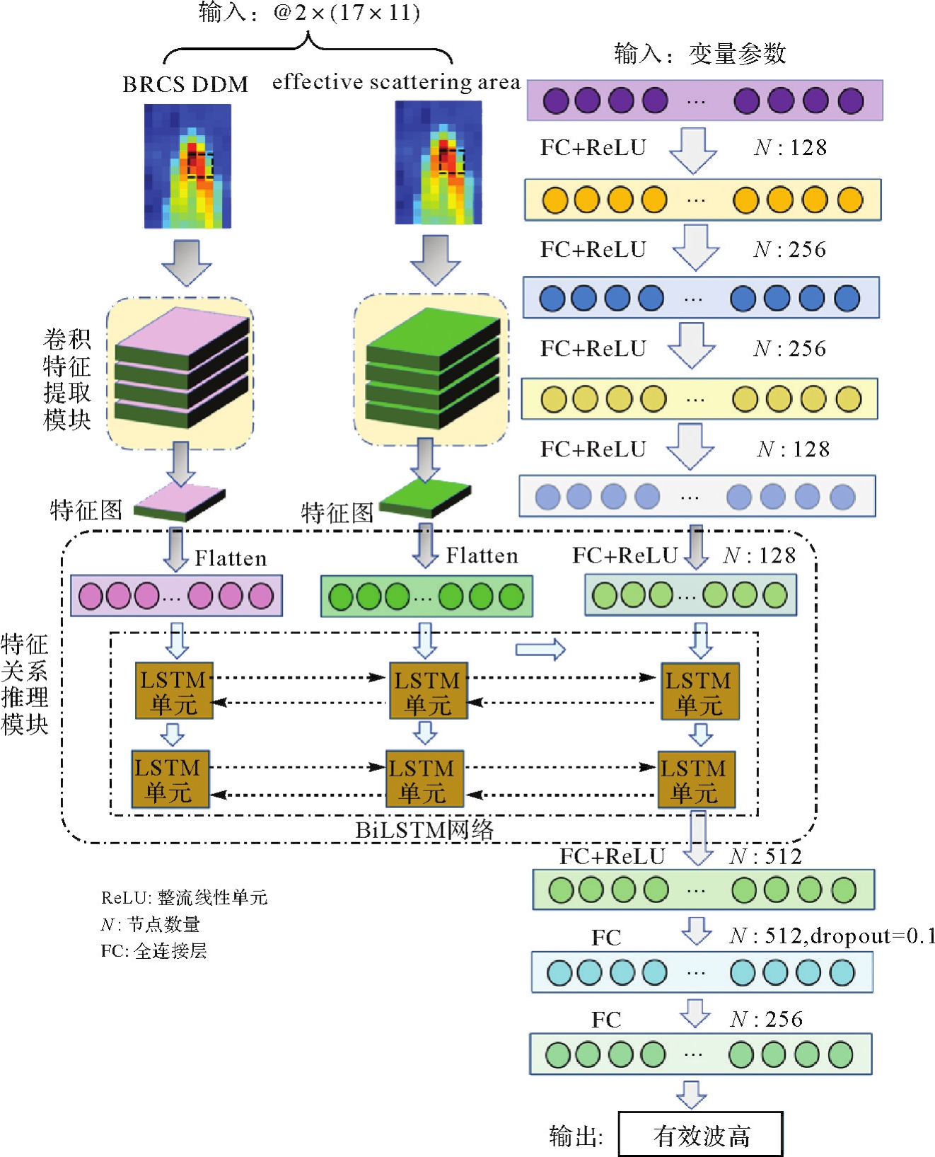
| [1] |
SOULAT F, CAPARRINI M, GERMAIN O, et al. Sea state monitoring using coastal GNSS-R[J]. Geophysical Research Letters, 2004, 31(21):L21303.
|
| [2] |
SHAH R, GARRISON J L, EGIDO A, et al. Bistatic radar measurements of significant wave height using signals of opportunity in L-, S-, and Ku-bands [J]. IEEE Transactions on Geoscience and Remote Sensing, 2016, 54(2):826-841.
|
| [3] |
ALONSO-ARROYO A, CAMPS A, PARK H, et al. Retrieval of significant wave height and mean sea surface level using the GNSS-R interference pattern technique: results from a three-month field campaign [J]. IEEE Transactions on Geoscience and Remote Sensing, 2015, 53(6):3198-3209.
|
| [4] |
王鑫, 孙强, 张训械, 等. 中国首次岸基GNSS-R海洋遥感实验[J]. 科学通报, 2008, 53(5):589-592.
|
|
WANG Xin, SUN Qiang, ZHANG Xunxie, et al. The first shore-based GNSS-R ocean remote sensing experiment in China[J]. Chinese Science Bulletin, 2008, 53(5):589-592.
|
| [5] |
邵连军, 张训械, 王鑫, 等. 利用GNSS-R信号反演海浪波高[J]. 武汉大学学报(信息科学版), 2008, 33(5):475-478.
|
|
SHAO Lianjun, ZHANG Xunxie, WANG Xin, et al. Sea surface wave height retrieve using GNSS-R signals[J]. Geomatics and Information Science of Wuhan University, 2008, 33(5):475-478.
|
| [6] |
金玲. GNSS-R接收机及有效波高反演方法研究[D]. 北京: 北京化工大学, 2016.
|
|
JIN Ling. Research on receiver and inversion method of significant wave height based on GNSS-R[D]. Beijing: Beijing University of Chemical Technology, 2016.
|
| [7] |
李颖, 朱雪瑗, 崔璨, 等. 船载GNSS-R有效波高测量的初步研究[J]. 海洋环境科学, 2016, 35(2):180-183.
|
|
LI Ying, ZHU Xueyuan, CUI Can, et al. Preliminary study on ship-borne significant wave height measurement using GNSS-R signals[J]. Marine Environmental Science, 2016, 35(2):180-183.
|
| [8] |
徐飞, 孙协昌, 刘馨宁, 等. 利用机载GNSS-R的有效波高反演技术[J]. 飞行器测控学报, 2017, 36(3):212-218.
|
|
XU Fei, SUN Xiechang, LIU Xinning, et al. A method of retrieval of significant wave height using airborne GNSS-R[J]. Journal of Spacecraft TT & C Technology, 2017, 36(3):212-218.
|
| [9] |
QIN Lingyu, LI Ying. Significant wave height estimation using multi-satellite observations from GNSS-R[J]. Remote Sensing, 2021, 13(23):4806.
|
| [10] |
俞永庆. 岸基GNSS反射信号有效波高反演研究[J]. 无线电工程, 2021, 51(10):1075-1079.
|
|
YU Yongqing. Retrieval of significant wave height using coastal GNSS reflectometry[J]. Radio Engineering, 2021, 51(10):1075-1079.
|
| [11] |
张一, 周立. 基于NARX回归神经网络的岸基GNSS-IR有效波高反演模型分析[J]. 测绘通报, 2022(2):90-94.
|
|
ZHANG Yi, ZHOU Li. Study on inversion model of significant wave height from shore-based GNSS-IR by using NARX recurrent neural network[J]. Bulletin of Surveying and Mapping, 2022(2):90-94.
|
| [12] |
WANG Xiaolei, HE Xiufeng, SHI Jian, et al. Estimating sea level, wind direction, significant wave height, and wave peak period using a geodetic GNSS receiver[J]. Remote Sensing of Environment, 2022, 279:113135.
|
| [13] |
ALPERS W, HASSELMANN K. Spectral signal to clutter and thermal noise properties of ocean wave imaging synthetic aperture radars[J]. International Journal of Remote Sensing, 1982, 3(4):423-446.
|
| [14] |
PENG Qin, JIN Shuanggen. Significant wave height estimation from space-borne cyclone-GNSS reflectometry[J]. Remote Sensing, 2019, 11(5):584.
|
| [15] |
YANG Shuai, JIN Shuanggen, JIA Yan, et al. Significant wave height estimation from joint CYGNSS DDMA and LES observations[J]. Sensors, 2021, 21(18):6123.
|
| [16] |
BU Jinwei, YU Kegen. Significant wave height retrieval method based on spaceborne GNSS reflectometry[J]. IEEE Geoscience and Remote Sensing Letters, 2022, 19:1503705.
|
| [17] |
BU Jinwei, YU Kegen. A new integrated method of CYGNSS DDMA and LES measurements for significant wave height estimation[J]. IEEE Geoscience and Remote Sensing Letters, 2022, 19:1505605.
|
| [18] |
布金伟, 余科根, 韩帅. 星载GNSS-R海浪有效波高反演模型构建[J]. 测绘学报, 2022, 51(9):1920-1930. DOI: 10.11947/j.AGCS.2022.20210284.
|
|
BU Jinwei, YU Kegen, HAN Shuai. Construction of spaceborne GNSS-R ocean waves significant wave height retrieval model[J]. Acta Geodaetica et Cartographica Sinica, 2022, 51(9):1920-1930. DOI: 10.11947/j.AGCS.2022.20210284.
|
| [19] |
ASGARIMEHR M, ARNOLD C, WEIGEL T, et al. GNSS reflectometry global ocean wind speed using deep learning: development and assessment of CyGNSSnet[J]. Remote Sensing of Environment, 2022, 269:112801.
|
| [20] |
WANG Feng, YANG Dongkai, YANG Lei. Retrieval and assessment of significant wave height from CYGNSS mission using neural network[J]. Remote Sensing, 2022, 14(15):3666.
|
| [21] |
WANG Changyang, YU Kegen, ZHANG Kefei, et al. Significant wave height retrieval based on multivariable regression models developed with CYGNSS data[J]. IEEE Transactions on Geoscience and Remote Sensing, 2023, 61:4200415.
|
| [22] |
BU Jinwei, YU Kegen, ZHU Feiyang, et al. Joint retrieval of sea surface rainfall intensity, wind speed, and wave height based on spaceborne GNSS-R: a case study of the oceans near China[J]. Remote Sensing, 2023, 15(11):2757.
|
| [23] |
BU Jinwei, YU Kegen, PARK H, et al. Estimation of swell height using spaceborne GNSS-R data from eight CYGNSS satellites[J]. Remote Sensing, 2022, 14(18):4634.
|
| [24] |
CLARIZIA M P, RUF C S, JALES P, et al. Spaceborne GNSS-R minimum variance wind speed estimator[J]. IEEE Transactions on Geoscience and Remote Sensing, 2014, 52(11):6829-6843.
|
| [25] |
REYNOLDS J, CLARIZIA M P, SANTI E. Wind speed estimation from CYGNSS using artificial neural networks[J]. IEEE Journal of Selected Topics in Applied Earth Observations and Remote Sensing, 2020, 13:708-716.
|
| [26] |
WANG Changyang, YU Kegen, QU Fangyu, et al. Spaceborne GNSS-R wind speed retrieval using machine learning methods[J]. Remote Sensing, 2022, 14(14):3507.
|
| [27] |
ERTUGRUL Ö F. A novel type of activation function in artificial neural networks: trained activation function[J]. Neural Networks, 2018, 99:148-157.
|
| [28] |
BU Jinwei, YU Kegen, NI Jun, et al. Combining ERA5 data and CYGNSS observations for the joint retrieval of global significant wave height of ocean swell and wind wave: a deep convolutional neural network approach[J]. Journal of Geodesy, 2023, 97(8):81.
|
| [29] |
SOISUVARN S, JELENAK Z, SAID F, et al. The GNSS reflectometry response to the ocean surface winds and waves [J]. IEEE Journal of Selected Topics in Applied Earth Observations and Remote Sensing, 2016, 9(10):4678-4699.
|


 ), 余科根2(