


测绘学报 ›› 2024, Vol. 53 ›› Issue (12): 2305-2315.doi: 10.11947/j.AGCS.2024.20230176
杨鹏1,2( ), 王振兴3, 田晓彬4, 郑世贵5, 黄勇1,2,6,7()
收稿日期:2023-06-06
出版日期:2025-01-06
发布日期:2025-01-06
通讯作者:
黄勇
E-mail:yangpeng183@mails.ucas.ac.cn;yongh@shao.ac.cn
作者简介:第一杨鹏(1996—),男,博士,研究方向为飞行器精密定轨及应用。E-mail:yangpeng183@mails.ucas.ac.cn
基金资助:
Peng YANG1,2(), Zhenxing WANG3, Xiaobin TIAN4, Shigui ZHENG5, Yong HUANG1,2,6,7()
Received:2023-06-06
Online:2025-01-06
Published:2025-01-06
Contact:
Yong HUANG
E-mail:yangpeng183@mails.ucas.ac.cn;yongh@shao.ac.cn
About author:YANG Peng (1996—), male, PhD, majors in spacecraft precision orbit determination and the application. E-mail: yangpeng183@mails.ucas.ac.cn
Supported by:摘要:
随着高轨卫星的广泛应用,其轨道精度需求越来越高。本文基于星载GNSS测量,仿真分析了位于倾斜地球同步轨道的SAR卫星定轨精度。结果表明,在满足信号可见性的条件下,IGSO卫星可见GPS+BDS导航星数平均约20颗,PDOP值在1~2之间;利用星载GNSS伪距/载波相位测量值可以得到优于1 m的高轨SAR卫星定轨精度,高阶勒让德误差波动小于10 mm;太阳辐射压摄动对轨道影响较大,10-8 m·s-2量级的模型误差最大可使定轨精度降低一个量级。
中图分类号:
杨鹏, 王振兴, 田晓彬, 郑世贵, 黄勇. 倾斜地球同步轨道SAR卫星星载GNSS定轨分析[J]. 测绘学报, 2024, 53(12): 2305-2315.
Peng YANG, Zhenxing WANG, Xiaobin TIAN, Shigui ZHENG, Yong HUANG. Analysis of orbit determination for inclined geosynchronous SAR using spaceborne GNSS data[J]. Acta Geodaetica et Cartographica Sinica, 2024, 53(12): 2305-2315.
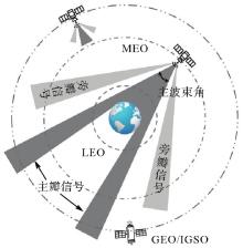
图1
高轨卫星对GNSS信号几何可见性"

表1
仿真高轨SAR卫星初轨参数(地球J2000.0惯性坐标系)"
| X/m | Y/m | Z/m | Vx/(m/s) | Vy/(m/s) | Vz/(m/s) |
|---|---|---|---|---|---|
| -41 452 082.322 | -5 412 500.806 | -5 489 111.997 | 288.690 020 | -2 968.636 335 | 747.034 417 |
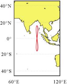
图2
仿真高轨SAR卫星星下点轨迹"

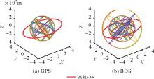
图3
仿真GNSS星座构型(地球J2000.0惯性坐标系)"
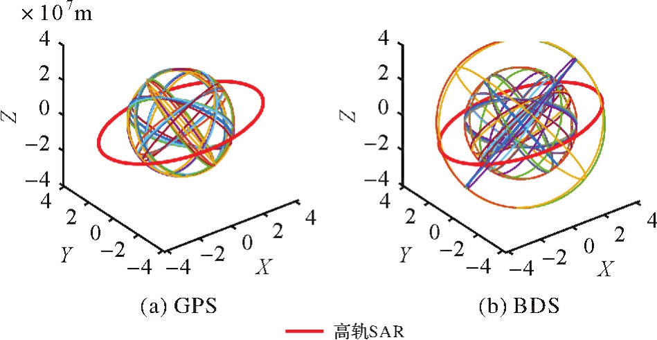

图4
高轨SAR卫星对GNSS信号可见性天顶图"
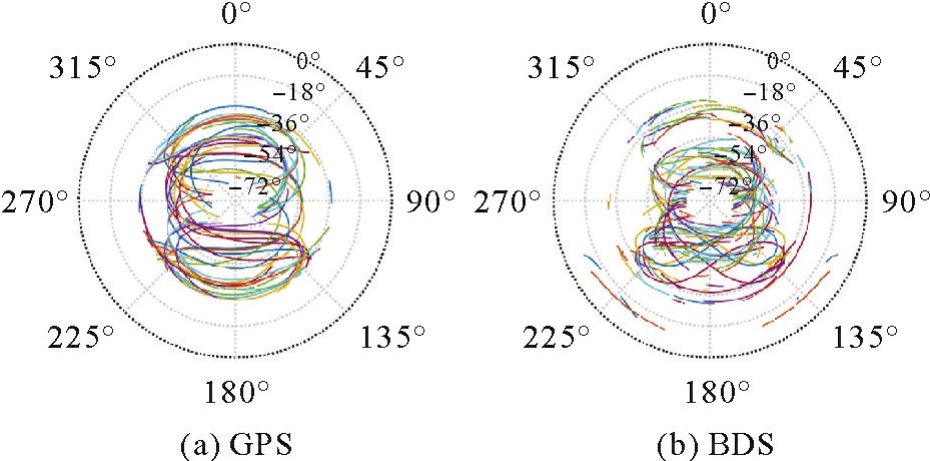
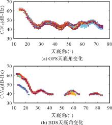
图5
高轨SAR卫星星载接收机信号强度随GNSS卫星天底角变化序列"
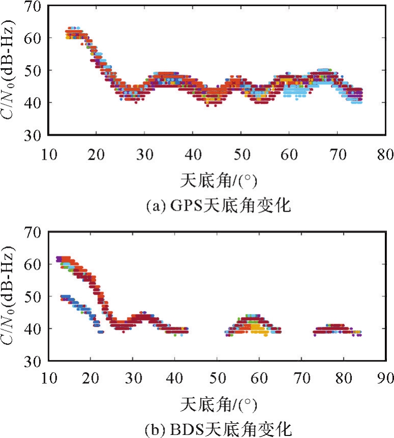
表2
仿真高轨SAR卫星工况概述"
| 工况 | 概述 |
|---|---|
| 工况1 | 定点指向巡航成像 |
| 工况2 | 卫星正飞 |
| 工况3 | 卫星正侧视成像 |
表3
仿真高轨SAR卫星各工况真轨道差异RMS"
| 工况 | 真轨道差异RMS |
|---|---|
| 工况1-工况2 | 11.94 |
| 工况1-工况3 | 74.37 |
| 工况2-工况3 | 70.49 |
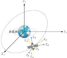
图6
相关坐标系定义"

表4
定轨策略"
| 参数 | 定轨策略 |
|---|---|
| 参考系 | 地心J2000.0 |
| 中心天体 | 地球 |
| N体摄动 | 太阳、大行星、地球以及月球,使用DE421历表 |
| 太阳辐射压 | 物理分析型模型 |
| 经验模型(固定面质比;ECOM) | |
| 非球形引力摄动 | 地球重力场模型JGM3(截取至20阶次) |
| 相对论摄动 | 参数化后牛顿模型[ |
| 解算参数 | 搭载星载接收机IGSO卫星位置速度 |
| 模糊度参数 | |
| 测量数据权重 | 伪距:1 m |
| 载波相位:0.01 m/s | |
| 积分器 | KSG二阶定步长积分器 |
| 积分步长 | 60 s |
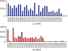
图7
星载接收机对各GNSS卫星观测值数量(工况1)"
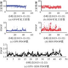
图8
星载接收机可见卫星数及PDOP值时间序列(工况1)"
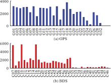
图9
星载接收机对各GNSS卫星观测值数量(工况2)"
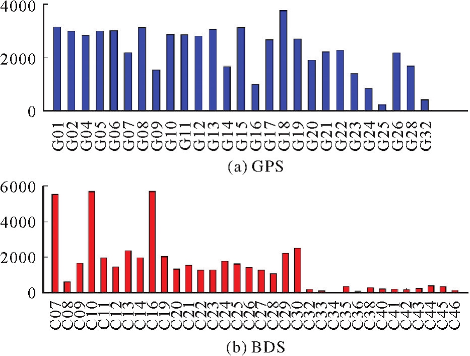
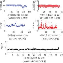
图10
星载接收机可见卫星数及PDOP值时间序列(工况2)"
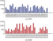
图11
星载接收机对各GNSS卫星观测值数量(工况3)"
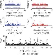
图12
星载接收机可见卫星数及PDOP值时间序列(工况3)"
表5
各工况定轨结果与真轨道差异"
| 工况 | 星座 | 定轨位置误差/m | |||
|---|---|---|---|---|---|
| R | T | N | total | ||
| 工况1 | GPS | 0.136 | 0.126 | 0.239 | 0.303 |
| BDS | 0.253 | 0.277 | 0.435 | 0.575 | |
| GPS+BDS | 0.118 | 0.090 | 0.227 | 0.271 | |
| 工况2 | GPS | 0.103 | 0.098 | 0.227 | 0.268 |
| BDS | 0.328 | 0.214 | 0.373 | 0.541 | |
| GPS+BDS | 0.109 | 0.086 | 0.206 | 0.248 | |
| 工况3 | GPS | 1.972 | 0.965 | 2.278 | 3.164 |
| BDS | 0.678 | 1.056 | 1.831 | 2.220 | |
| GPS+BDS | 0.315 | 0.908 | 1.908 | 2.136 | |
图13
高轨SAR卫星定轨后与真轨道差异勒让德展开式高阶项误差波动"
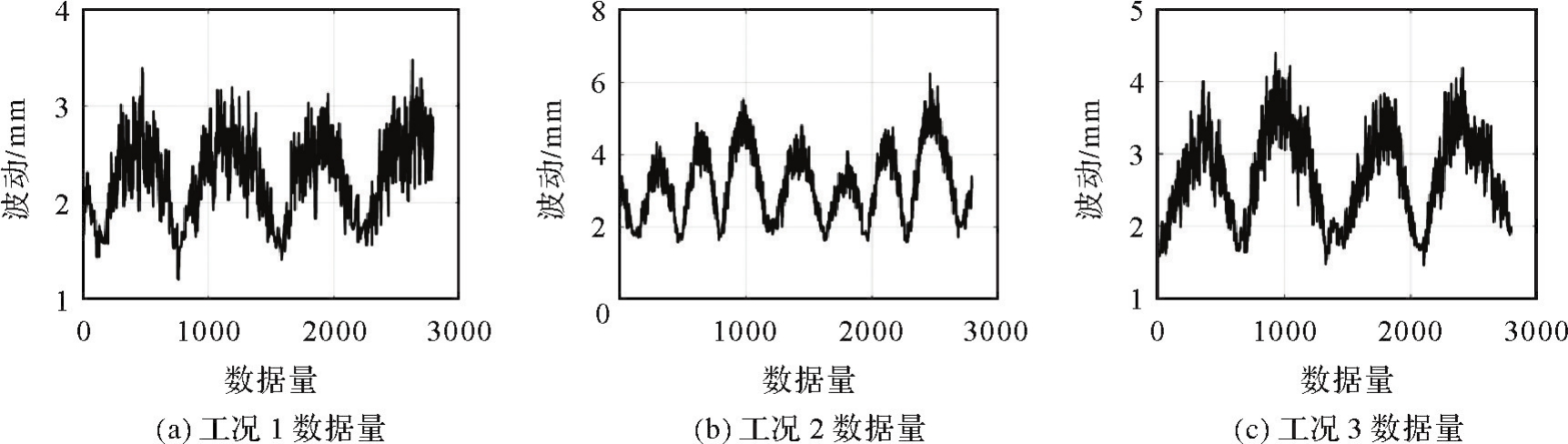
表6
各工况定轨结果与真轨道差异(固定面质比光压模型)"
| 工况 | 星座 | 定轨位置误差/m | |||
|---|---|---|---|---|---|
| R | T | N | total | ||
| 工况1 | GPS | 1.346 | 0.666 | 0.825 | 1.714 |
| BDS | 1.262 | 0.789 | 0.729 | 1.657 | |
| GPS+BDS | 1.260 | 0.674 | 0.680 | 1.583 | |
| 工况2 | GPS | 0.170 | 0.220 | 0.222 | 0.355 |
| BDS | 0.509 | 0.333 | 0.522 | 0.801 | |
| GPS+BDS | 0.179 | 0.214 | 0.202 | 0.344 | |
| 工况3 | GPS | 2.497 | 1.555 | 2.539 | 3.886 |
| BDS | 1.782 | 1.183 | 1.438 | 2.577 | |
| GPS+BDS | 1.827 | 1.360 | 2.009 | 3.037 | |
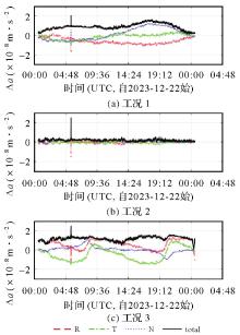
图14
仿真高轨SAR卫星太阳辐射压摄动加速差异(物理分析型-经验型)"
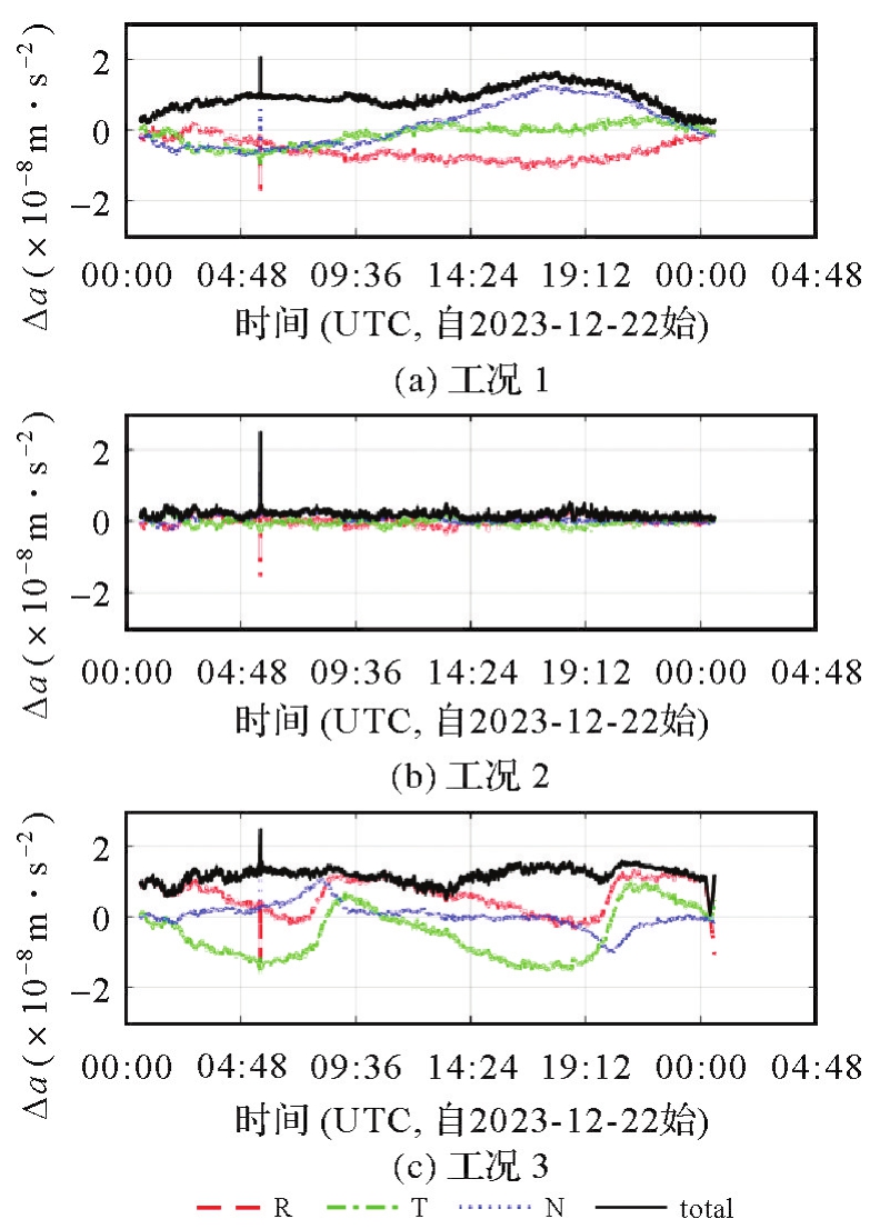
表7
各工况定轨结果与真轨道差异(六参数ECOM光压模型)"
| 工况 | 星座 | 定轨位置误差/m | |||
|---|---|---|---|---|---|
| R | T | N | total | ||
| 工况1 | GPS | 1.084 | 0.184 | 0.431 | 1.181 |
| BDS | 1.501 | 0.386 | 0.500 | 1.629 | |
| GPS+BDS | 1.259 | 0.189 | 0.373 | 1.327 | |
| 工况2 | GPS | 1.186 | 0.143 | 0.296 | 1.230 |
| BDS | 0.884 | 0.327 | 0.373 | 1.014 | |
| GPS+BDS | 1.174 | 0.139 | 0.292 | 1.218 | |
| 工况3 | GPS | 13.949 | 1.951 | 3.326 | 14.472 |
| BDS | 2.250 | 0.963 | 1.885 | 3.089 | |
| GPS+BDS | 1.834 | 1.118 | 2.030 | 2.956 | |
| [1] | 赵彦珍. 基于GNSS的高轨卫星定位技术研究[D]. 北京: 中国科学院国家空间科学中心, 2016. |
| ZHAO Yanzhen. Research on positioning technology of high orbit satellite based on GNSS[D]. Beijing: National Space Science Center, Chinese Academy of Sciences, 2016. | |
| [2] | 杜兰. GEO卫星精密定轨技术研究[D]. 郑州: 信息工程大学, 2006. |
| DU Lan. Research on precise orbit determination technology of GEO satellite[D]. Zhengzhou: Information Engineering University, 2006. | |
| [3] | 郭睿, 胡小工, 唐波, 等. 多种测量技术条件下的GEO卫星定轨研究[J]. 科学通报, 2010, 55(6): 428-434. |
| GUO Rui, HU Xiaogong, TANG Bo, et al. Research on GEO satellite orbit determination under the condition of various measurement techniques[J]. Chinese Science Bulletin, 2010, 55(6): 428-434. | |
| [4] | 邢楠, 唐成盼, 李晓杰, 等. 北斗三号GEO卫星的RDSS定轨精度分析[J]. 中国科学:物理学力学天文学, 2021, 51(1): 96-102. |
| XING Nan, TANG Chengpan, LI Xiaojie, et al. RDSS orbit determination accuracy analysis of BeiDou-3 GEO satellite[J]. Chinese Science: Physics, Mechanics and Astronomy, 2021, 51(1): 96-102. | |
| [5] | 刘泽军, 杜兰, 张栩晨, 等. 基于Ku波段CEI的GEO卫星定轨特性[J]. 导航定位学报, 2021, 9(1): 38-43. |
| LIU Zejun, DU Lan, ZHANG Xuchen, et al. Analysis on orbit determination of GEO satellite based on Ku-band CEI[J]. Journal of Navigation and Positioning, 2021, 9(1): 38-43. | |
| [6] | BAUER F, MOREAU M, DAHLE-MELSAETHER M E, et al. The GPS space service volume[C]//Proceedings of 2006 ION GNSS. Fort Worth: IEEE, 2006. |
| [7] |
王猛, 单涛, 王盾. 高轨航天器GNSS技术发展[J]. 测绘学报, 2020, 49(9): 1158-1167. DOI:.
doi: 10.11947/J.AGCS.2020.20200170 |
|
WANG Meng, SHAN Tao, WANG Dun. Development of GNSS technology for high earth orbit spacecraft[J]. Acta Geodaetica et Cartographica Sinica, 2020, 49(9): 1158-1167. DOI:.
doi: 10.11947/J.AGCS.2020.20200170 |
|
| [8] | 樊敏, 胡小工, 李海涛, 等. 月球探测器GNSS信号可见性分析改进方法及应用[J]. 航天器工程, 2022, 31(2): 19-28. |
| FAN Min, HU Xiaogong, LI Haitao, et al. Improvement method and application of GNSS signal visibility analysis for lunar probes[J]. Spacecraft Engineering, 2022, 31(2): 19-28. | |
| [9] | WOOD T. The LANDSAT/global positioning system project[C]//Proceedings of 1988 Flight Mechanics Conference of Estimation Theory Symposium. Greenbelt: [s.n.], 1988: 1-23. |
| [10] | VSVEHLA D, ROTHACHER M. Kinematic and reduced-dynamic precise orbit determination of low earth orbiters[J]. Advances in Geosciences, 2003, 1: 47-56. |
| [11] | VAN DEN IJSSEL J, VISSER P, PATIÑO RODRIGUEZ E. Champ precise orbit determination using GPS data[J]. Advances in Space Research, 2003, 31(8): 1889-1895. |
| [12] | HAINES B, BERTIGER W, DESAI S, et al. Initial orbit determination results for Jason-1: towards a 1 cm orbit[J]. Navigation, 2003, 50(3): 171-180. |
| [13] | KANG Z, NAGEL P, PASTOR R. Precise orbit determination for GRACE[J]. Advances in Space Research, 2003, 31(8): 1875-1881. |
| [14] | 李凯. 基于星载GNSS的低轨卫星精密定轨研究[D]. 北京: 中国科学院大学, 2020. |
| LI Kai. Research on precise orbit determination of LEO satellite based on spaceborne GNSS[D]. Beijing: University of Chinese Academy of Sciences, 2020. | |
| [15] | 李冰, 刘蕾, 王猛. GEO卫星GNSS导航在轨长期性能验证与分析[J]. 上海航天, 2017, 34(4): 133-143. |
| LI Bing, LIU Lei, WANG Meng. Performance demonstration and analysis of GNSS navigation in GEO satellites[J]. Aerospace Shanghai (Chinese & English), 2017, 34(4): 133-143. | |
| [16] | 赵兴隆. 低轨星座提升北斗空间信号精度关键技术及星载GNSS定轨研究[D]. 北京: 中国科学院大学, 2021. |
| ZHAO Xinglong. Research on key technologies of improving BeiDou space signal accuracy by LEO constellation and orbit determination by satellite-borne GNSS[D]. Beijing: University of Chinese Academy of Sciences, 2021. | |
| [17] | APOLLONI B, CARRARA A, MURINO P. Use of elevation models for landform analysis by SEASAT-SAR imagery[J]. Acta Astronautica, 1982, 9(6/7): 365-374. |
| [18] | RUDENKO S, OTTEN M, VISSER P, et al. New improved orbit solutions for the ERS-1 and ERS-2 satellites[J]. Advances in Space Research, 2012, 49(8): 1229-1244. |
| [19] | MOTOHKA T, KANKAKU Y, MIURA S, et al. Overview of ALOS-2 and ALOS-4 L-band SAR[C]//Proceedings of 2021 IEEE Radar Conference. Atlanta: IEEE, 2021: 1-4. |
| [20] | 黄震, 赵双明, 常青. 国产高分三号卫星干涉测量试验[J]. 测绘地理信息, 2021, 46(4): 7-11. |
| HUANG Zhen, ZHAO Shuangming, CHANG Qing. Measurement experiment of domestically produced GaoFen-3 satellite interferometry[J]. Surveying and Mapping Geographic Information, 2021, 46(4): 7-11. | |
| [21] |
李涛, 唐新明, 高小明, 等. SAR卫星业务化地形测绘能力分析与展望[J]. 测绘学报, 2021, 50(7): 891-904. DOI:.
doi: 10.11947/j.AGCS.2017.20160485 |
|
LI Tao, TANG Xinming, GAO Xiaoming, et al. Analysis and outlook of the operational topographic surveying and mapping capability of the SAR satellites[J]. Acta Geodaetica et Cartographica Sinica, 2021, 50(7): 891-904. DOI:.
doi: 10.11947/j.AGCS.2017.20160485 |
|
| [22] | 江冕, 黄丽佳, 胡文龙, 等. 地球同步轨道SAR定轨精度要求分析[J]. 系统工程与电子技术, 2017, 39(1): 71-78. |
| JIANG Mian, HUANG Lijia, HU Wenlong, et al. Analysis of accuracy requirements for geosynchronous orbit SAR orbit determination[J]. Systems Engineering and Electronic Technology, 2017, 39(1): 71-78. | |
| [23] | 何清举, 孙前贵. 利用GNSS实现高轨卫星自主导航的新方案[J]. 飞行器测控学报, 2010, 29(1): 7-11. |
| HE Qingju, SUN Qiangui. A new solution of autonomous navigation for GEO satellites based on GNSS[J]. Journal of Spacecraft TT&C Technology, 2010, 29(1): 7-11. | |
| [24] | 巴晓辉, 刘海洋, 郑睿, 等. 一种有效的GNSS接收机载噪比估计方法[J]. 武汉大学学报(信息科学版), 2011, 36(4): 457-460, 466. |
| BA Xiaohui, LIU Haiyang, ZHENG Rui, et al. An effective carrier-to-noise ratio estimation method for GNSS receiver[J]. Geomatics and Information Science of Wuhan University, 2011, 36(4): 457-460, 466. | |
| [25] | 邓旭, 吕志伟, 周玟龙, 等. 采用载噪比的卫星导航欺骗检测算法设计[J]. 导航定位学报, 2022, 10(2): 109-118. |
| DENG Xu, LÜ Zhiwei, ZHOU Wenlong, et al. Design of satellite navigation deception detection algorithm using carrier to noise ratio[J]. Journal of Navigation and Positioning, 2022, 10(2): 109-118. | |
| [26] | ANTHONY R, KERNS R. NAVSTAR GPS space segment/navigation user segment interfaces[R]. El Segundo: GPS Joint Program Office, 2022: 15-17. |
| [27] | 胡国荣, 欧吉坤, 崔伟宏. 星载GPS载波相位相对定轨方法研究[J]. 遥感学报, 2000, 21(4): 311-315. |
| HU Guorong, OU Jikun, CUI Weihong. Research on GPS-based orbit determination with carrier phase for low-orbit satellites[J]. National Remote Sensing Bulletin, 2000, 21(4): 311-315. | |
| [28] | 宇伟, 金双根, 高飞, 等. 复杂结构卫星太阳辐射压模型的建立与分析[J]. 武汉大学学报(信息科学版), 2017, 42(6): 817-824. |
| YU Wei, JIN Shuanggen, GAO Fei, et al. Establishment and analysis of solar radiation pressure model for complex structure satellites[J]. Geomatics and Information Science of Wuhan University, 2017, 42(6): 817-824. | |
| [29] | 卢鋆, 张弓, 陈谷仓, 等. 卫星导航系统发展现状及前景展望[J]. 航天器工程, 2020, 29(4): 1-10. |
| LU Jun, ZHANG Gong, CHEN Gucang, et al. Development status and prospects of satellite navigation systems[J]. Spacecraft Engineering, 2020, 29(4): 1-10. | |
| [30] | 蒋科材. 基于星载GNSS弱信号的高轨航天器精密定轨研究[D]. 武汉: 武汉大学, 2020. |
| JIANG Kecai. Research on precise orbit determination of high orbit spacecraft based on weak signal of spaceborne GNSS[D]. Wuhan: Wuhan University, 2020. | |
| [31] | 黄勇, 胡小工, 曹建锋, 等. 上海天文台火星卫星定轨软件系统[J]. 飞行器测控学报, 2009, 28(6): 83-89. |
| HUANG Yong, HU Xiaogong, CAO Jianfeng, et al. The Mars satellite orbit determination software at Shanghai astronomical observatory[J]. Journal of Spacecraft TT&C Technology, 2009, 28(6): 83-89. | |
| [32] | MOYER T D. Formulation for observed and computed values of deep space network data types for navigation[M]. 1 ed. Hoboken: Wiley, 2003. |
| [33] | 田雨润, 禹卫东. 地球同步轨道SAR精确斜距模型研究[J]. 电子与信息学报, 2014, 36(8): 1960-1965. |
| TIAN Yurun, YU Weidong. Accurate slant range model analysis of geosynchronous SAR[J]. Journal of Electronics & Information Technology, 2014, 36(8): 1960-1965. | |
| [34] | LIU Junhong, GU Defeng, JU Bing, et al. A new empirical solar radiation pressure model for BeiDou GEO satellites[J]. Advances in Space Research, 2016, 57(1): 234-244. |
| [35] |
毛悦, 宋小勇, 贾小林, 等. 北斗卫星ECOM光压模型参数选择策略分析[J]. 测绘学报, 2017, 46(11): 1812-1821. DOI:.
doi: 10.11947/J.AGCS.2017.20160485 |
|
MAO Yue, SONG Xiaoyong, JIA Xiaolin, et al. Analysis about parameters selection strategy of ECOM solar radiation pressure model for BeiDou satellites[J]. Acta Geodaetica et Cartographica Sinica, 2017, 46(11): 1812-1821. DOI:.
doi: 10.11947/J.AGCS.2017.20160485 |
|
| [36] | 毛悦, 宋小勇, 王维, 等. 北斗IGSO/MEO卫星姿态控制及光压差异分析[J]. 测绘科学, 2015, 40(8): 129-134. |
| MAO Yue, SONG Xiaoyong, WANG Wei, et al. BeiDou IGSO and MEO navigation satellites' yaw-steering and orbit-normal attitude control modes and solar radiation pressure difference analysis[J]. Science of Surveying and Mapping, 2015, 40(8): 129-134. |
| [1] | 布金伟, 刘淑慧, 徐顺双, 向彤粟, 汪秋兰, 籍超颖, 左小清. 星载GNSS-R全球海浪波周期估计的经验模型构建[J]. 测绘学报, 2026, 55(4): 684-697. |
| [2] | 马中民, 张双成, 周昕, 刘奇, 刘宁, 王恒利. 顾及地表反射率不确定性的风云三号GNSS-R洪涝监测方法:以8·2广东极端暴雨灾害为例[J]. 测绘学报, 2026, 55(3): 451-464. |
| [3] | 满海钧, 曹建峰, 鞠冰, 李勰, 孔静, 刘山洪. “天问一号”探测器轨道确定及精度评估[J]. 测绘学报, 2024, 53(7): 1288-1297. |
| [4] | 胡超, 王潜心. 顾及BDS-3星钟约束的GNSS超快速轨道钟差解算方法[J]. 测绘学报, 2024, 53(3): 413-424. |
| [5] | 李楠, 温俊健, 刘艳阳, 凌惠祥, 魏春, 陈筠力. L波段差分干涉SAR卫星严格回归轨道优化设计方法[J]. 测绘学报, 2024, 53(10): 1873-1880. |
| [6] | 曲伟菁, 黄勇, 徐君毅, 孙淑贤, 周善石, 杨宇飞, 何冰, 胡小工. 星地SLR和星间链路的BDS-3卫星精密定轨[J]. 测绘学报, 2023, 52(9): 1437-1448. |
| [7] | 李星星, 李婕, 袁勇强, 郑鸿杰, 黄适, 刘城伯, 张柯柯. 北斗三号卫星经验型太阳光压模型分析与精化[J]. 测绘学报, 2022, 51(8): 1680-1689. |
| [8] | 李星星, 张伟, 袁勇强, 张柯柯, 吴家齐, 娄嘉庆, 李婕, 郑鸿杰. GNSS卫星精密定轨综述:现状、挑战与机遇[J]. 测绘学报, 2022, 51(7): 1271-1293. |
| [9] | 邓志国, 王君刚, 葛茂荣. GBM快速轨道产品及非差模糊度固定对其精度的改进[J]. 测绘学报, 2022, 51(4): 544-555. |
| [10] | 陈力, 张德新, 陈筠力, 邵晓巍. 分布式InSAR卫星系统编队指标体系研究[J]. 测绘学报, 2022, 51(12): 2433-2439. |
| [11] | 高敬坤, 汪志龙, 程家胜, 丛琳, 范炜康, 胡振龙. 天绘二号双星方位向天线方向图在轨测量关键技术[J]. 测绘学报, 2022, 51(12): 2470-2480. |
| [12] | 张勤, 燕兴元, 黄观文, 解世超, 曹钰. 北斗卫星天线相位中心改正模型精化及对精密定轨和定位影响分析[J]. 测绘学报, 2020, 49(9): 1101-1111. |
| [13] | 李星星, 黄健德, 袁勇强, 李婕, 刘城伯, 朱艺婷. Galileo三频非组合精密定轨模型及精度评估[J]. 测绘学报, 2020, 49(9): 1120-1130. |
| [14] | 李杰, 张荣之, 曾光, 龚兵, 王冲, 房亚男, 朱俊, 李军锋, 强文. 北斗三频数据的两个无电离层组合轨道钟差估计及其应用[J]. 测绘学报, 2020, 49(11): 1377-1387. |
| [15] | 胡一帆, 张帅. 不同卫星天线参数对BDS定轨定位精度的影响[J]. 测绘学报, 2019, 48(7): 908-918. |
| 阅读次数 | ||||||
|
全文 |
|
|||||
|
摘要 |
|
|||||