


测绘学报 ›› 2025, Vol. 54 ›› Issue (2): 371-384.doi: 10.11947/j.AGCS.2025.20240145
黄哲琨( ), 钱海忠(), 蔡中祥, 王骁, 王俊威, 孔令辉
收稿日期:2024-04-12
出版日期:2025-03-11
发布日期:2025-03-11
通讯作者:
钱海忠
E-mail:zhekunhuang@aliyun.com;haizhongqian@163.com
作者简介:黄哲琨(1998—),男,博士生,研究方向为空间数据分析与挖掘。 E-mail:zhekunhuang@aliyun.com
基金资助:
Zhekun HUANG(), Haizhong QIAN(), Zhongxiang CAI, Xiao WANG, Junwei WANG, Linghui KONG
Received:2024-04-12
Online:2025-03-11
Published:2025-03-11
Contact:
Haizhong QIAN
E-mail:zhekunhuang@aliyun.com;haizhongqian@163.com
About author:HUANG Zhekun (1998—), male, PhD candidate, majors in spatial data mining. E-mail: zhekunhuang@aliyun.com
Supported by:摘要:
多尺度网状河系匹配是水系数据集成、融合与更新的重要组成部分。鉴于现有网状河系匹配方法未对匹配模式进行预先识别,并缺乏针对性的匹配策略,本文提出基于图神经网络的多尺度网状河系分类匹配方法。首先,将大比例尺网状河系构建为图结构,将其与小比例尺河系之间的匹配模式作为节点的标注,并计算节点特征;然后,利用图神经网络对节点特征进行采样和聚合,建立起河段特征与匹配模式之间的映射关系;最后,根据河系中各河段的匹配模式类别,对其采取相应的匹配策略。试验结果表明,本文方法有效提高了网状河系的匹配精度,具备较好的理论与应用价值。
中图分类号:
黄哲琨, 钱海忠, 蔡中祥, 王骁, 王俊威, 孔令辉. 基于图神经网络的多尺度网状河系分类匹配方法[J]. 测绘学报, 2025, 54(2): 371-384.
Zhekun HUANG, Haizhong QIAN, Zhongxiang CAI, Xiao WANG, Junwei WANG, Linghui KONG. A multi-scale mesh river system classification matching method based on graph neural network[J]. Acta Geodaetica et Cartographica Sinica, 2025, 54(2): 371-384.
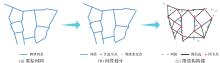
图1
网状河系的图结构构建"
表1
制图综合与匹配模式的关系"
| 综合操作 | 大比例尺数据 | 小比例尺数据 | 大比例尺数据对应的匹配模式 |
|---|---|---|---|
| 选取 |  |  | 1∶0、1∶1和m∶1 |
| 化简 |  |  | 1∶1 |
图2
河段的特征项说明"

图3
邻居采样和聚合过程"

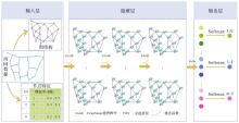
图4
基于GraphSAGE的匹配模式分类框架"

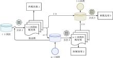
图5
匹配流程"
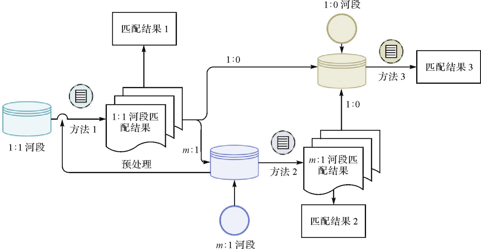
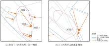
图6
匹配模式的冲突示例"

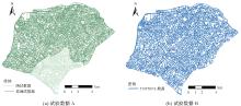
图7
试验区域1"

表2
不同机器学习方法的匹配模式分类精度"
| 方法 | 向量维度或决策树数 | 准确率/(%) |
|---|---|---|
| 本文方法 | 64 | 90.7 |
| 128 | 91.5 | |
| 256 | 91.2 | |
| GCN | 64 | 75.4 |
| 128 | 76.7 | |
| 256 | 76.2 | |
| GAT | 64 | 73.1 |
| 128 | 74.6 | |
| 256 | 74.7 | |
| RF | 50 | 82.2 |
| 100 | 84.1 | |
| 200 | 84.9 |
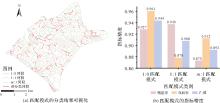
图8
测试集的匹配模式分类结果"
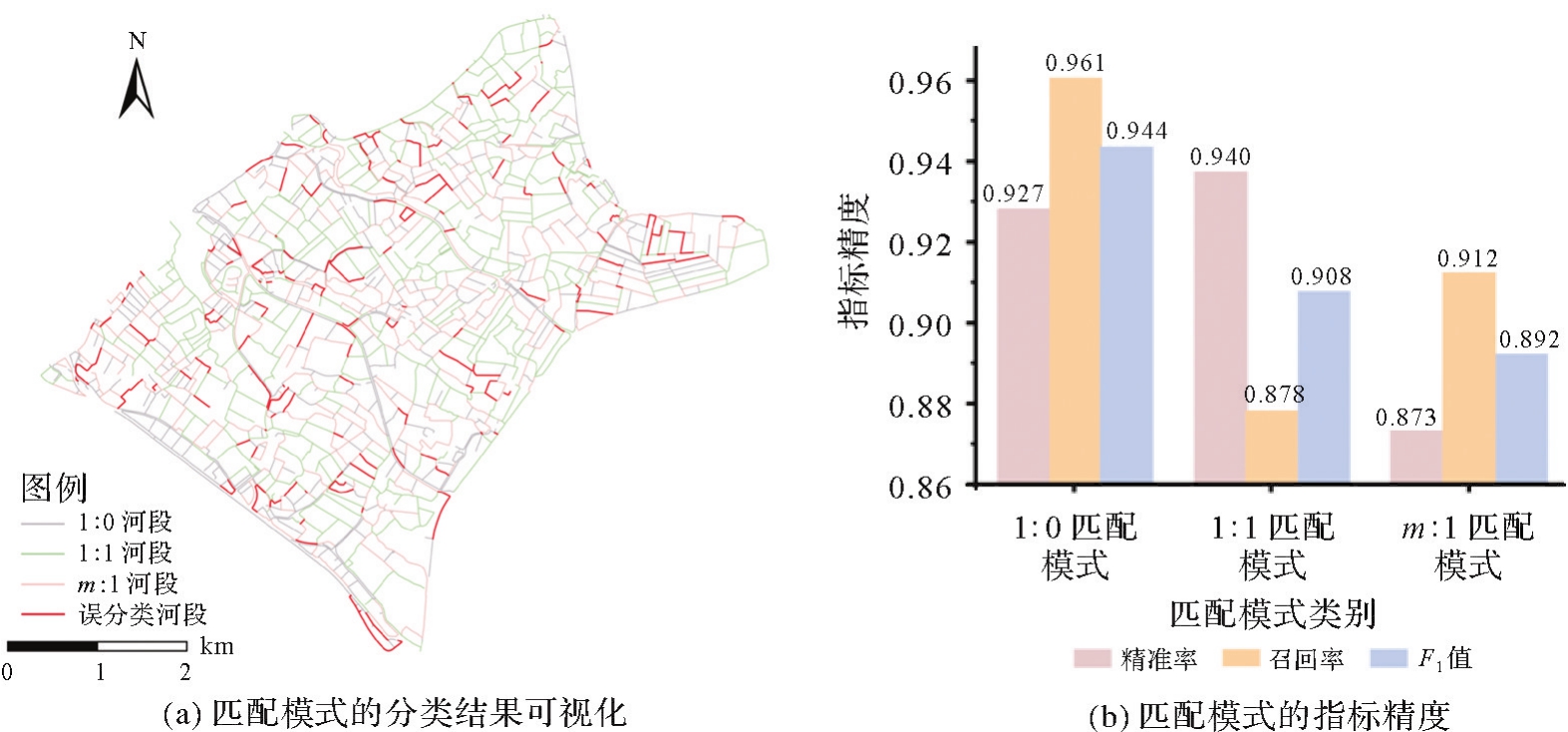
表3
各匹配模式的错误预测结果"
| 匹配模式(真实) | 匹配模式(预测) | 案例数 |
|---|---|---|
| 1∶0 | 1∶1 | 16 |
| m∶1 | 10 | |
| 1∶1 | 1∶0 | 25 |
| m∶1 | 72 | |
| m∶1 | 1∶0 | 25 |
| 1∶1 | 29 |
表4
不同匹配模式的各评价指标统计结果"
| 匹配模式 | C | M | A | 精准率/(%) | 召回率/(%) | F1值/(%) |
|---|---|---|---|---|---|---|
| 1∶0 | 650 | 714 | 661 | 91.0 | 98.3 | 94.5 |
| 1∶1 | 778 | 794 | 796 | 98.0 | 97.7 | 97.8 |
| m∶1 | 549 | 634 | 610 | 86.6 | 90.0 | 88.3 |
| 总计 | 1338 | 1441 | 1424 | 92.9 | 94.0 | 93.4 |
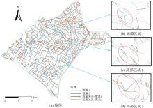
图9
网状河系的匹配结果"

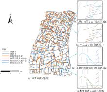
图10
试验区2的对比结果"

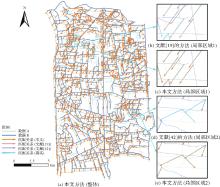
图11
试验区3的对比结果"

表5
各试验区的匹配模式分类精度"
| 试验区域 | 匹配模式 | 精准率/(%) | 召回率/(%) | F1值/(%) |
|---|---|---|---|---|
| 试验区2 | 1∶0 | 90.8 | 94.18 | 92.47 |
| 1∶1 | 83.5 | 82.15 | 82.82 | |
| m∶1 | 76.6 | 75.23 | 75.93 | |
| 试验区3 | 1∶0 | 90.1 | 89.1 | 89.6 |
| 1∶1 | 81.8 | 80.6 | 81.2 | |
| m∶1 | 79.8 | 81.8 | 80.8 |
表6
不同匹配方法的各评价指标统计结果"
| 试验区域 | 匹配方法 | C | M | A | 精准率/(%) | 召回率/(%) | F1值/(%) |
|---|---|---|---|---|---|---|---|
| 试验区2 | 文献[ | 601 | 760 | 811 | 79.1 | 74.1 | 76.5 |
| 文献[ | 619 | 825 | 811 | 75.0 | 76.3 | 75.6 | |
| 本文方法 | 751 | 804 | 811 | 93.4 | 92.6 | 93.0 | |
| 试验区3 | 文献[ | 841 | 1080 | 1149 | 77.9 | 73.2 | 75.5 |
| 文献[ | 868 | 1221 | 1149 | 71.1 | 75.5 | 73.2 | |
| 本文方法 | 1043 | 1127 | 1149 | 92.5 | 90.8 | 91.6 |
| [1] | CHEN Jun, LI Zhilin, LI Songnian, et al. From digitalized to intelligentized surveying and mapping: fundamental issues and research agenda[J]. Journal of Geodesy and Geoinformation Science, 2022, 5(2): 148-160. |
| [2] | MENG Liqun. Proliferation of cartographic education in the age of big data[J]. Journal of Geodesy and Geoinformation Science, 2022, 5(3): 7-18. |
| [3] | SHEN Yilang, ZHAO Rong, AI Tinghua, et al. A raster-based method for the hierarchical selection of river networks based on stream characteristics[J]. International Journal of Geographical Information Science, 2023, 37(10): 2262-2287. |
| [4] | HERZOG S P, WARD A S, WONDZELL S M. Multiscale feature-feature interactions control patterns of hyporheic exchange in a simulated headwater mountain stream[J]. Water Resources Research, 2019, 55(12): 10976-10992. |
| [5] | DURIGHETTO N, VINGIANI F, BERTASSELLO L E, et al. Intraseasonal drainage network dynamics in a headwater catchment of the Italian Alps[J]. Water Resources Research, 2020, 56(4): e2019WR025563. |
| [6] | LKHAZRAJI H, KANAKIS T, AL-SHERBAZ A, et al. Enhancing map matching accuracy using backtracking technique[J]. International Journal of Applied Earth Observation and Geoinformation, 2024, 132: 103988. |
| [7] | WU Hangbin, XU Shan, HUANG Shengke, et al. Optimal road matching by relaxation to min-cost network flow[J]. International Journal of Applied Earth Observation and Geoinformation, 2022, 114: 103057. |
| [8] | CHEHREGHAN A, ALI ABBASPOUR R. A geometric-based approach for road matching on multi-scale datasets using a genetic algorithm[J]. Cartography and Geographic Information Science, 2018, 45(3): 255-269. |
| [9] |
刘凌佳, 朱道也, 朱欣焰, 等. 基于MBR组合优化算法的多尺度面实体匹配方法[J]. 测绘学报, 2018, 47(5): 652-662. DOI:.
doi: 10.11947/j.AGCS.2018.20160625 |
|
LIU Lingjia, ZHU Daoye, ZHU Xinyan, et al. A multi-scale polygonal object matching method based on MBR combinatorial optimization algorithm[J]. Acta Geodaetica et Cartographica Sinica, 2018, 47(5): 652-662. DOI:.
doi: 10.11947/j.AGCS.2018.20160625 |
|
| [10] |
陈竞男, 钱海忠, 王骁, 等. 提高线要素匹配率的动态化简方法[J]. 测绘学报, 2016, 45(4): 486-493. DOI:.
doi: 10.11947/j.AGCS.2016.20150074 |
|
CHEN Jingnan, QIAN Haizhong, WANG Xiao, et al. Improving the matching rate of line feature by using dynamic simplification[J]. Acta Geodaetica et Cartographica Sinica, 2016, 45(4): 486-493. DOI:.
doi: 10.11947/j.AGCS.2016.20150074 |
|
| [11] | GUO Wenyue, YU Anzhu, SUN Qun, et al. A multisource contour matching method considering the similarity of geometric features[J]. Journal of Geodesy and Geoinformation Science, 2020, 3(3): 76-87. |
| [12] | 安晓亚, 孙群, 肖强, 等. 一种形状多级描述方法及在多尺度空间数据几何相似性度量中的应用[J]. 测绘学报, 2011, 40(4): 495-501, 508. |
| AN Xiaoya, SUN Qun, XIAO Qiang, et al. A shape multilevel description method and application in measuring geometry similarity of multi-scale spatial data[J]. Acta Geodaetica et Cartographica Sinica, 2011, 40(4): 495-501, 508. | |
| [13] | DENG Min, LI Zhilin, CHEN Xiaoyong. Extended Hausdorff distance for spatial objects in GIS[J]. International Journal of Geographical Information Science, 2007, 21(4): 459-475. |
| [14] | ZHANG Meng, MENG Liqiu, BOBRICH J. A road-network matching approach guided by “structure”[J]. Annals of GIS, 2010, 16(3): 165-176. |
| [15] | ABDOLMAJIDI E, MANSOURIAN A, WILL J, et al. Matching authority and VGI road networks using an extended node-based matching algorithm[J]. Geo-spatial Information Science, 2015, 18(2/3): 65-80. |
| [16] |
郭庆胜, 谢育武, 刘纪平, 等. 顾及尺度变化和数据更新的道路网匹配算法[J]. 测绘学报, 2017, 46(3): 381-388. DOI:.
doi: 10.11947/j.AGCS.2017.20160364 |
|
GUO Qingsheng, XIE Yuwu, LIU Jiping, et al. Algorithms for road networks matching considering scale variation and data update[J]. Acta Geodaetica et Cartographica Sinica, 2017, 46(3): 381-388. DOI:.
doi: 10.11947/j.AGCS.2017.20160364 |
|
| [17] | 邵世维, 刘辉, 肖立霞, 等. 一种基于Fréchet距离的复杂线状要素匹配方法[J]. 武汉大学学报(信息科学版), 2018, 43(4): 516-521. |
| SHAO Shiwei, LIU Hui, XIAO Lixia, et al. A complex linear feature of Fréchet distance matching method[J]. Geomatics and Information Science of Wuhan University, 2018, 43(4): 516-521. | |
| [18] | 禄小敏, 闫浩文, 王中辉. 群组目标空间方向关系建模[J]. 地球信息科学学报, 2018, 20(6): 721-729. |
| LU Xiaomin, YAN Haowen, WANG Zhonghui. The modeling of spatial direction relationship between object groups[J]. Journal of Geo-information Science, 2018, 20(6): 721-729. | |
| [19] |
付仲良, 杨元维, 高贤君, 等. 道路网多特征匹配优化算法[J]. 测绘学报, 2016, 45(5): 608-615. DOI:.
doi: 10.11947/j.AGCS.2016.20150388 |
|
FU Zhongliang, YANG Yuanwei, GAO Xianjun, et al. An optimization algorithm for multi-characteristics road network matching[J]. Acta Geodaetica et Cartographica Sinica, 2016, 45(5): 608-615. DOI:.
doi: 10.11947/j.AGCS.2016.20150388 |
|
| [20] | KIM I H, FENG C C, WANGY C. A simplified linear feature matching method using decision tree analysis, weighted linear directional mean, and topological relationships[J]. International Journal of Geographical Information Science, 2017, 31(5): 1042-1060. |
| [21] | HUANGB H, ZHONG W, ZHAI R J, et al. Hierarchical area partitioning method of urban road networks matching[J]. Journal of Geodesy and Geoinformation Science, 2019, 2(3): 55-67. |
| [22] | 闫浩文, 张鑫港, 禄小敏, 等. DP算法自动实现方法:以河流化简为例[J]. 武汉大学学报(信息科学版), 2024, 49(2): 264-270. |
| YAN Haowen, ZHANG Xingang, LU Xiaomin, et al. Approach to automating DP algorithm: taking river simplification as an example[J]. Geomatics and Information Science of Wuhan University, 2024, 49(2): 264-270. | |
| [23] | ZHANG Jianchen, WANG Yanhui, ZHAO Wenji. An improved probabilistic relaxation method for matching multi-scale road networks[J]. International Journal of Digital Earth, 2018, 11(6): 635-655. |
| [24] | LI L N, GOODCHILD M F. An optimisation model for linear feature matching in geographical data conflation[J]. International Journal of Image and Data Fusion, 2011, 2(4): 309-328. |
| [25] | TONG Xiaohua, LIANG Dan, JIN Yanmin. A linear road object matching method for conflation based on optimization and logistic regression[J]. International Journal of Geographical Information Science, 2014, 28(4): 824-846. |
| [26] | 张云菲, 杨必胜, 栾学晨. 利用概率松弛法的城市路网自动匹配[J]. 测绘学报, 2012, 41(6): 933-939. |
| ZHANG Yunfei, YANG Bisheng, LUAN Xuechen. Automated matching urban road networks using probabilistic relaxation[J]. Acta Geodaetica et Cartographica Sinica, 2012, 41(6): 933-939. | |
| [27] | YANG Bisheng, ZHANG Yunfei, LUAN Xuechen. A probabilistic relaxation approach for matching road networks[J]. International Journal of Geographical Information Science, 2013, 27(2): 319-338. |
| [28] | LEI T L. Geospatial data conflation: a formal approach based on optimization and relational databases[J]. International Journal of Geographical Information Science, 2020, 34(11): 2296-2334. |
| [29] | LEI T L. Large scale geospatial data conflation: a feature matching framework based on optimization and divide-and-conquer[J]. Computers, Environment and Urban Systems, 2021, 87: 101618. |
| [30] | YU Wenhao, LIU Mengqi. An iterative framework with active learning to match segments in road networks[J]. Cartography and Geographic Information Science, 2023, 50(4): 333-350. |
| [31] | 武芳, 杜佳威, 钱海忠, 等. 地图综合智能化研究的发展与思考[J]. 武汉大学学报(信息科学版), 2022, 47(10): 1675-1687. |
| WU Fang, DU Jiawei, QIAN Haizhong, et al. Overview of research progress and reflections in intelligent map generalization[J]. Geomatics and Information Science of Wuhan University, 2022, 47(10): 1675-1687. | |
| [32] |
艾廷华. 深度学习赋能地图制图的若干思考[J]. 测绘学报, 2021, 50(9): 1170-1182. DOI:.
doi: 10.11947/j.AGCS.2021.20210091 |
|
AI Tinghua. Some thoughts on deep learning enabling cartography[J]. Acta Geodaetica et Cartographica Sinica, 2021, 50(9): 1170-1182. DOI:.
doi: 10.11947/j.AGCS.2021.20210091 |
|
| [33] |
张新长, 何显锦, 孙颖, 等. 多尺度空间数据联动更新技术研究现状及展望[J]. 测绘学报, 2022, 51(7): 1520-1535. DOI:.
doi: 10.11947/j.AGCS.2022.20220095 |
|
ZHANG Xinchang, HE Xianjin, SUN Ying, et al. Advance and future development of the multi-scale spatial data linkage updating[J]. Acta Geodaetica et Cartographica Sinica, 2022, 51(7): 1520-1535. DOI:.
doi: 10.11947/j.AGCS.2022.20220095 |
|
| [34] | YU Huafei, AI Tinghua, YANG Min, et al. Automatic segmentation of parallel drainage patterns supported by a graph convolution neural network[J]. Expert Systems with Applications, 2023, 211: 118639. |
| [35] | WANG Wenning, YAN Haowen, LU Xiaomin, et al. Drainage pattern recognition method considering local basin shape based on graph neural network[J]. International Journal of Digital Earth, 2023, 16(1): 593-619. |
| [36] | 武芳, 谭笑, 王辉连, 等. 顾及网络特征的复杂人工河网的自动选取[J]. 中国图象图形学报, 2007, 12(6): 1103-1109. |
| WU Fang, TAN Xiao, WANG Huilian, et al. Study on automated canal selection[J]. Journal of Image and Graphics, 2007, 12(6): 1103-1109. | |
| [37] | 翟仁健, 武芳, 邓红艳, 等. 基于遗传多目标优化的人工河网自动选取模型[J]. 测绘学报, 2008, 37(1): 108-113. |
| ZHAI Renjian, WU Fang, DENG Hongyan, et al. An automated selection model of ditch based on multi-objective optimization by genetic algorithm[J]. Acta Geodaetica et Cartographica Sinica, 2008, 37(1): 108-113. | |
| [38] |
段佩祥, 钱海忠, 何海威, 等. 案例支撑下的朴素贝叶斯树状河系自动分级方法[J]. 测绘学报, 2019, 48(8): 975-984. DOI:.
doi: 10.11947/j.AGCS.2019.20180370 |
|
DUAN Peixiang, QIAN Haizhong, HE Haiwei, et al. Naive Bayes-based automatic classification method of tree-like river network supported by cases[J]. Acta Geodaetica et Cartographica Sinica, 2019, 48(8): 975-984. DOI:.
doi: 10.11947/j.AGCS.2019.20180370 |
|
| [39] | WANG Di, QIAN Haizhong. Graph neural network method for the intelligent selection of river system[J]. Geocarto International, 2023, 38(1): 2252762. |
| [40] | YU Huafei, AI Tinghua, YANG Min, et al. A recognition method for drainage patterns using a graph convolutional network[J]. International Journal of Applied Earth Observation and Geoinformation, 2022, 107: 102696. |
| [41] | MAAS A L, HANNUN A Y, NG A Y. Rectifier nonlinearities improve neuralnetwork acoustic models[C]//Proceedings of 2013 International Conference on Machine Learning. Atlanta: JMLR, 2013. |
| [42] | 刘海龙, 钱海忠, 王骁, 等. 采用层次分析法的道路网整体匹配方法[J]. 武汉大学学报(信息科学版), 2015, 40(5): 644-651. |
| LIU Hailong, QIAN Haizhong, WANG Xiao, et al. Road networks global matching method using analytical hierarchy process[J]. Geomatics and Information Science of Wuhan University, 2015, 40(5): 644-651. |
| [1] | 张付兵, 孙群, 徐青, 马京振, 黄文君, 陈若虚. 随机森林和图神经网络支持下的河系自动分级与选取方法[J]. 测绘学报, 2025, 54(9): 1697-1711. |
| [2] | 唐佳怡, 童晓冲, 邱春平, 雷亚现, 雷毅, 宋好帅. 基于场景图的遥感场景检索方法[J]. 测绘学报, 2025, 54(1): 123-135. |
| [3] | 孔博, 艾廷华, 杨敏, 吴昊, 余华飞, 肖天元. 等高线形态知识与图神经网络联合作用下的黄土地貌类型识别[J]. 测绘学报, 2024, 53(6): 1154-1164. |
| [4] | 陈占龙, 鲁谢春, 徐永洋. 基于图顶点深度聚类的建筑物合并方法[J]. 测绘学报, 2024, 53(4): 736-749. |
| [5] | 陈小卫, 张保明, 郭海涛, 赵传, 徐俊峰. 利用自由形状线特征的遥感影像分级匹配方法[J]. 测绘学报, 2017, 46(2): 208-217. |
| [6] | 李世忠, 程承旗, 王东, 濮国梁, 陈波. 基于全球剖分网格的地理空间信息保障服务技术研究[J]. 测绘学报, 2016, 45(S1): 115-120. |
| 阅读次数 | ||||||
|
全文 |
|
|||||
|
摘要 |
|
|||||