


测绘学报 ›› 2026, Vol. 55 ›› Issue (7): 1212-1228.doi: 10.11947/j.AGCS.2026.20260094
• 大地测量学与导航 • 上一篇
李军( ), 祝会忠(), 李博, 路阳阳, 王子嘉, 刘智强
收稿日期:2026-03-19
修回日期:2026-06-29
发布日期:2026-08-18
通讯作者:
祝会忠
E-mail:lijun_ch@lntu.edu.cn;zhuhuizhong@lntu.edu.cn
作者简介:李军(1994—),男,博士,讲师,研究方向为GNSS地基增强定位算法。 E-mail:lijun_ch@lntu.edu.cn
基金资助:
Jun Li(), Huizhong Zhu(), Bo Li, Yangyang Lu, Zijia Wang, Zhiqiang Liu
Received:2026-03-19
Revised:2026-06-29
Published:2026-08-18
Contact:
Huizhong Zhu
E-mail:lijun_ch@lntu.edu.cn;zhuhuizhong@lntu.edu.cn
About author:Li Jun (1994—), male, PhD, lecturer, majors in GNSS ground-based enhanced positioning algorithm. E-mail: lijun_ch@lntu.edu.cn
Supported by:摘要:
高精度定位和定轨服务依赖参考站的准确坐标,在实时传输计算过程中无法实现对参考站坐标的保密,为此本文提出了基于空间误差相关性的参考站位置偏置方法,在进行参考站位置偏置时,认为偏置参考站的大气误差与原参考站一致,同时结合偏置参考站到卫星的几何距离,生成原参考站附近的偏置参考站,偏置参考站观测值与原参考站观测值误差特性一致,可以代替实际参考站实现高精度定位定轨服务。为评估偏置参考站对高精度定位和精密定轨的影响,本文对偏置参考站的PPP-RTK定位、网络RTK定位、精密轨道确定的性能进行分析。试验结果表明,利用偏置参考站代替实际参考站提供服务时,当原始参考站网各参考站随机偏置900 m时,对NL-UPD估计和PPP-RTK定位结果的影响很小,不影响高精度的PPP-RTK定位。对网络RTK分析表明,参考站位置偏置对模糊度解算和误差改正精度的影响,会随着偏置距离的增大而变大;当位置偏置达到5000 m时,参考站解算的浮点模糊度差异会明显增大,非差误差改正数差异也急速增大,但不影响用户的网络RTK高精度定位,对区域增强定位的影响有限。各参考站随机偏置900 m时,位置偏置对精密定轨的影响也较小,影响最大的BDS-IGSO精密轨道,最大值也仅为8.4 mm,满足高精度精密定轨的要求。
中图分类号:
李军, 祝会忠, 李博, 路阳阳, 王子嘉, 刘智强. 一种适用于高精度定位及定轨的参考站位置偏置方法[J]. 测绘学报, 2026, 55(7): 1212-1228.
Jun Li, Huizhong Zhu, Bo Li, Yangyang Lu, Zijia Wang, Zhiqiang Liu. Reference station position moving method for high-precision positioning and orbit determination[J]. Acta Geodaetica et Cartographica Sinica, 2026, 55(7): 1212-1228.
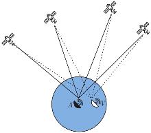
图1
偏置观测值的生成"
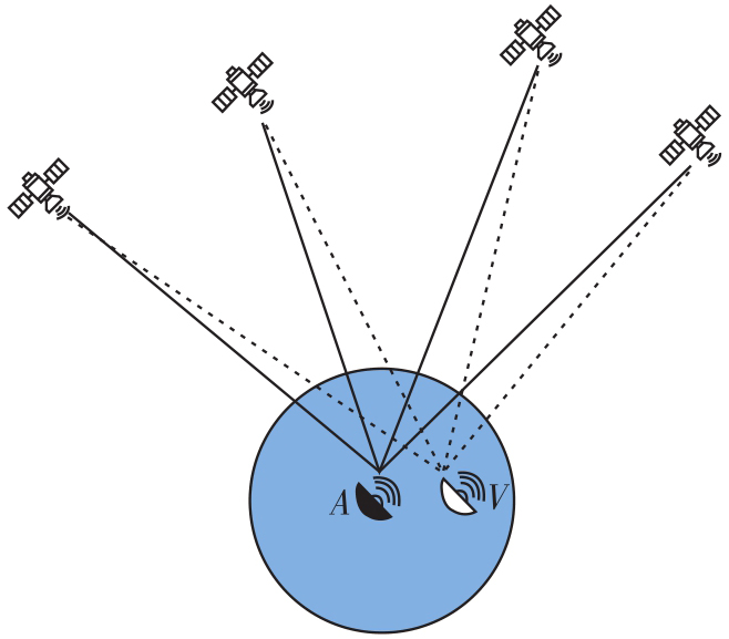

表1
偏置参考站与实际参考站的误差比较"
| 参考站类型 | 接收机端误差 | 卫星端误差 | 大气延迟误差 |
|---|---|---|---|
| 实际参考站 | 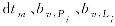 |  |  |
| 偏置参考站 | 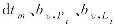 |  |  |
图2
PPP-RTK技术流程"
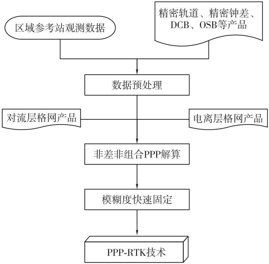
表2
精密定轨观测模型"
| 参数 | 描述 |
|---|---|
| 观测量 | 非差无电离层组合 |
| 估计器 | 最小二乘 |
| 卫星系统 | BDS-3、GPS、Galileo |
| 观测值权 | 高度角定权 |
| 截止高度角 | 7° |
| 卫星钟差 | 历元白噪声进行估计 |
| 卫星天线相位中心改正 | GPS:M14.ATX改正PCO/PCV |
| BDS:M14.ATX仅改正PCO | |
| 对流层延迟 | SAAS+GMF投影 |
| 接收机钟差 | 过程估计+白噪声 |
| 系统间延迟 | 按常数估计 |
| 模糊度 | 固定解 |
表3
精密定轨动力学模型"
| 模型 | 处理策略 |
|---|---|
| 轨道积分 | RKF+Adams |
| 卫星姿态 | 名义姿态 |
| 天线推力 | 改正 |
| 地球反照辐射 | 改正 |
| 太阳光压 | GPS:ECOM1光压模型 |
| BDS:ECOM2+EMP光压模型 | |
| Galileo:ECOM1+BW模型 | |
| 潮汐 | 固体潮、海潮和极潮 |
| N体引力 | 太阳、月亮和其他行星 |
| 地球重力场 | 12阶次EGM |
图3
全球测站分布"
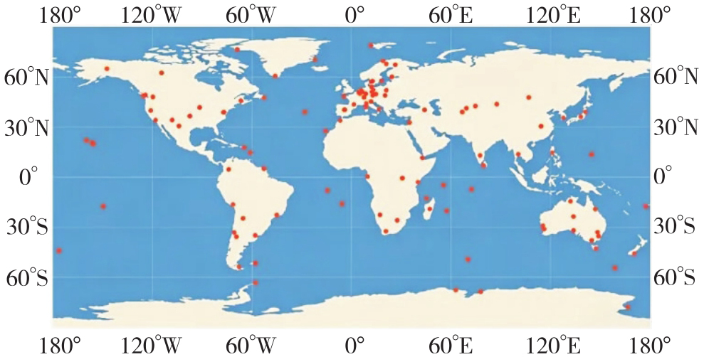
表4
参考站位置偏置距离"
| 偏置 | 最大距离 | 最小距离 | 中位数 | 平均值 |
|---|---|---|---|---|
| 距离/m | 887.75 | 68.30 | 414.19 | 430.32 |
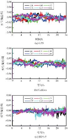
图4
参考站位置偏置NL-UPD差值序列"
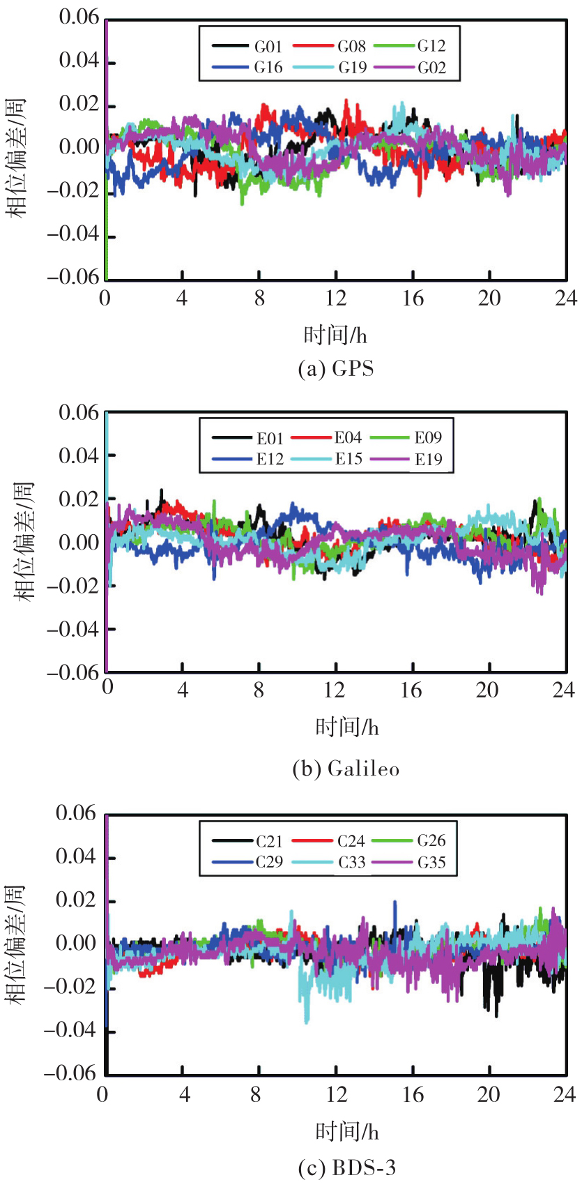
表5
位置偏置对NL-UPD解算的影响"
| 卫星 | 偏置前/周 | 偏置后/周 | 差异/周 |
|---|---|---|---|
| GPS | 0.018 1 | 0.018 3 | 0.002 |
| Galileo | 0.018 1 | 0.019 0 | 0.009 |
| BDS-3 | 0.038 5 | 0.038 3 | 0.002 |
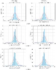
图5
参考站位置偏置对NL-UPD解算残差的影响"

表6
位置偏置对NL-UPD解算残差的影响"
| 卫星 | [-0.10,0.10]周 | [-0.15,0.15]周 | ||
|---|---|---|---|---|
| 偏置前 | 偏置后 | 偏置前 | 偏置后 | |
| GPS | 88.83 | 88.70 | 93.25 | 93.17 |
| Galileo | 90.09 | 90.12 | 94.34 | 94.30 |
| BDS-3 | 82.46 | 82.43 | 88.86 | 88.82 |
表7
参考站位置偏置对PPP的影响统计"
| 测站 | 偏置距离/m | E/mm | N/mm | U/mm | 收敛时间/s |
|---|---|---|---|---|---|
| ABPO | 525 | 0.5 | 0.3 | 0 | 0 |
| ALIC | 431 | 0.6 | 0.4 | 0.7 | 30 |
| AMC4 | 807 | 0.7 | 0.1 | 0.4 | 0 |
| AREG | 440 | 0.9 | 0.1 | 0.2 | 30 |
| ARHT | 261 | 0 | 0 | 0.3 | 0 |
| ARUC | 400 | 0.3 | 0.1 | 0.5 | 30 |
| ASCG | 447 | 0.5 | 0.1 | 0.2 | 0 |
| BAMF | 381 | 0.5 | 0 | 0.2 | 0 |
| BOGT | 538 | 0.4 | 0.3 | 0.1 | 0 |
| BREW | 76 | 0 | 0.1 | 0 | 0 |
| BRST | 382 | 0 | 0.1 | 0.1 | 0 |
| BRUX | 679 | 0.1 | 0.5 | 0.8 | 30 |
| BSHM | 748 | 0.1 | 0.1 | 0.6 | 0 |
| CEBR | 800 | 0.9 | 0.1 | 0.2 | 60 |
| CEDU | 83 | 0 | 0 | 0.1 | 0 |
| 均值 | 466 | 0.36 | 0.15 | 0.29 | 12 |
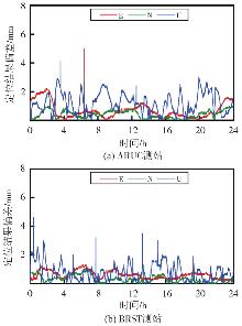
图6
ARUC测站和BRST测站位置偏置前后位置差异"
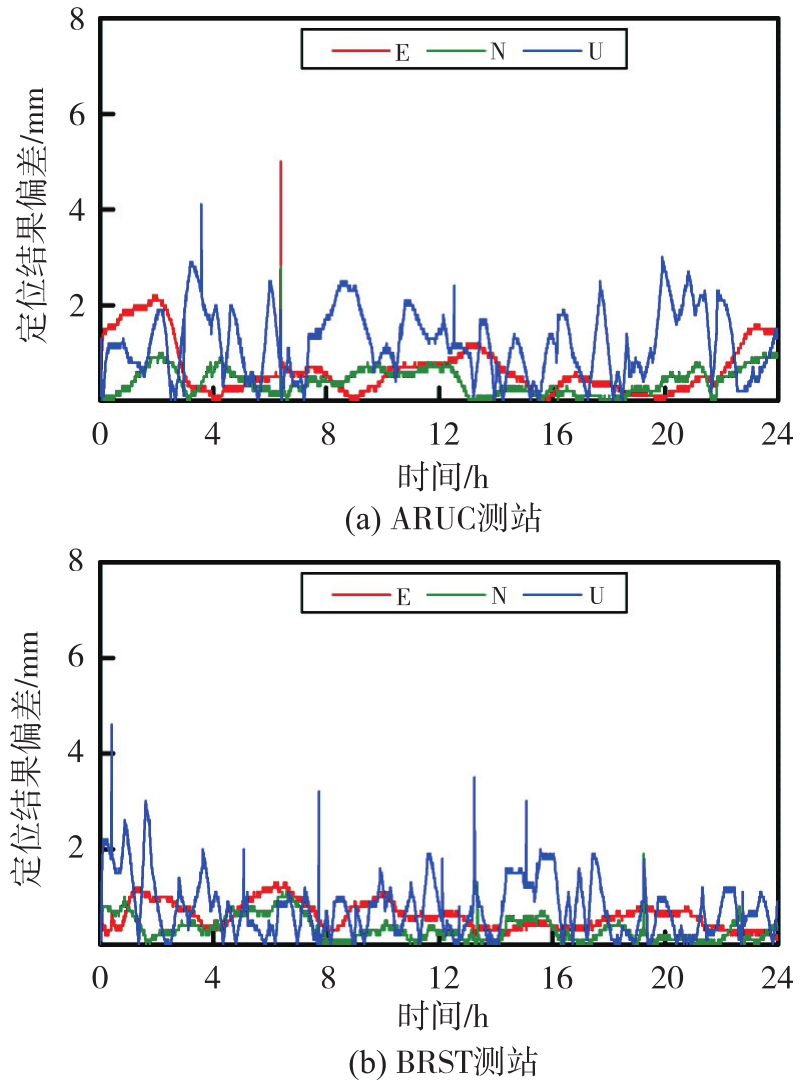
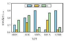
图7
参考站位置偏置对定位结果的影响"
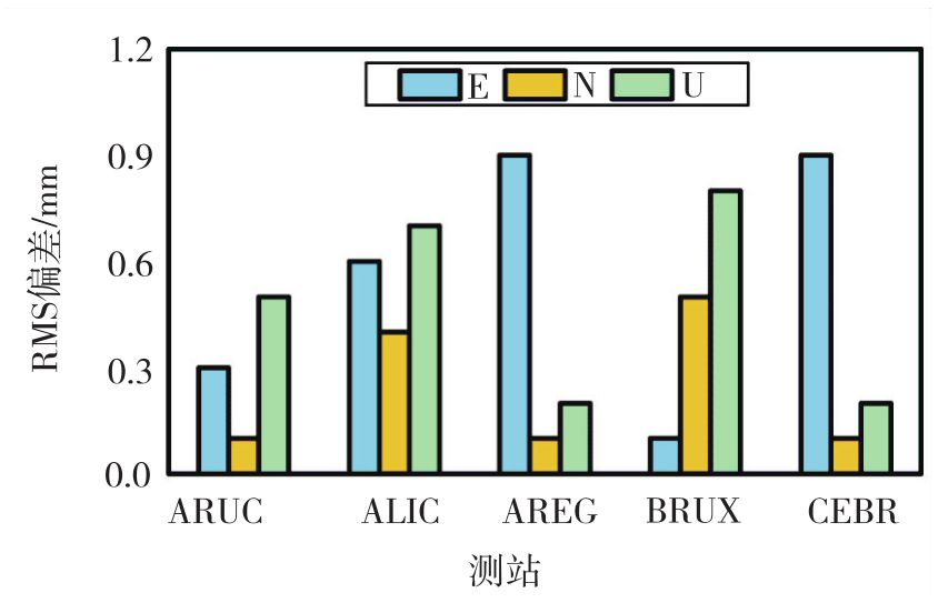
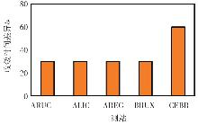
图8
参考站位置偏置对收敛时间的影响"
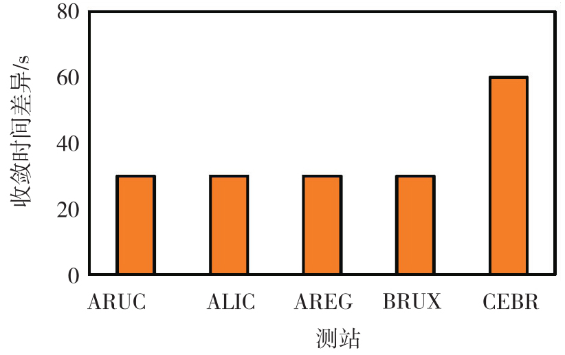
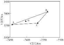
图9
测站分布"
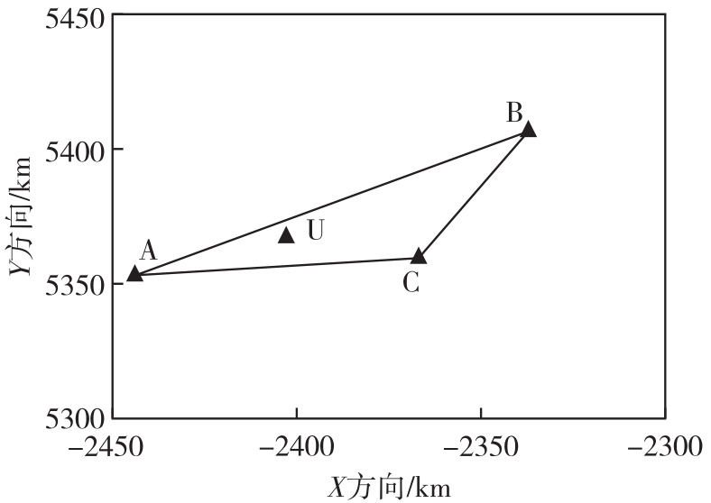
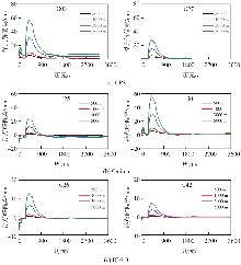
图10
不同偏置距离的浮点模糊度差异随时间的变化"
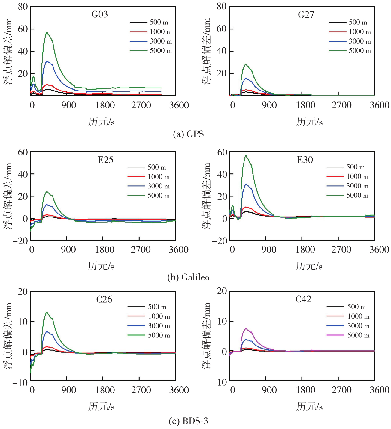
表8
模糊度浮点解RMS的变化"
| 卫星 | RMS | |||||
|---|---|---|---|---|---|---|
| 100 m | 500 m | 1000 m | 2000 m | 3000 m | 5000 m | |
| G03 | 1.58 | 2.21 | 3.60 | 6.21 | 10.44 | 18.70 |
| G27 | 0.94 | 1.34 | 1.77 | 2.67 | 4.34 | 7.77 |
| E25 | 0.36 | 0.72 | 1.25 | 2.35 | 3.83 | 7.11 |
| E30 | 1.85 | 2.36 | 3.26 | 5.97 | 8.69 | 15.77 |
| C26 | 0.29 | 0.67 | 0.79 | 1.23 | 1.94 | 3.66 |
| C42 | 0.06 | 0.19 | 0.29 | 0.87 | 1.04 | 2.04 |
图11
参考站不同偏置距离的误差改正数变化"
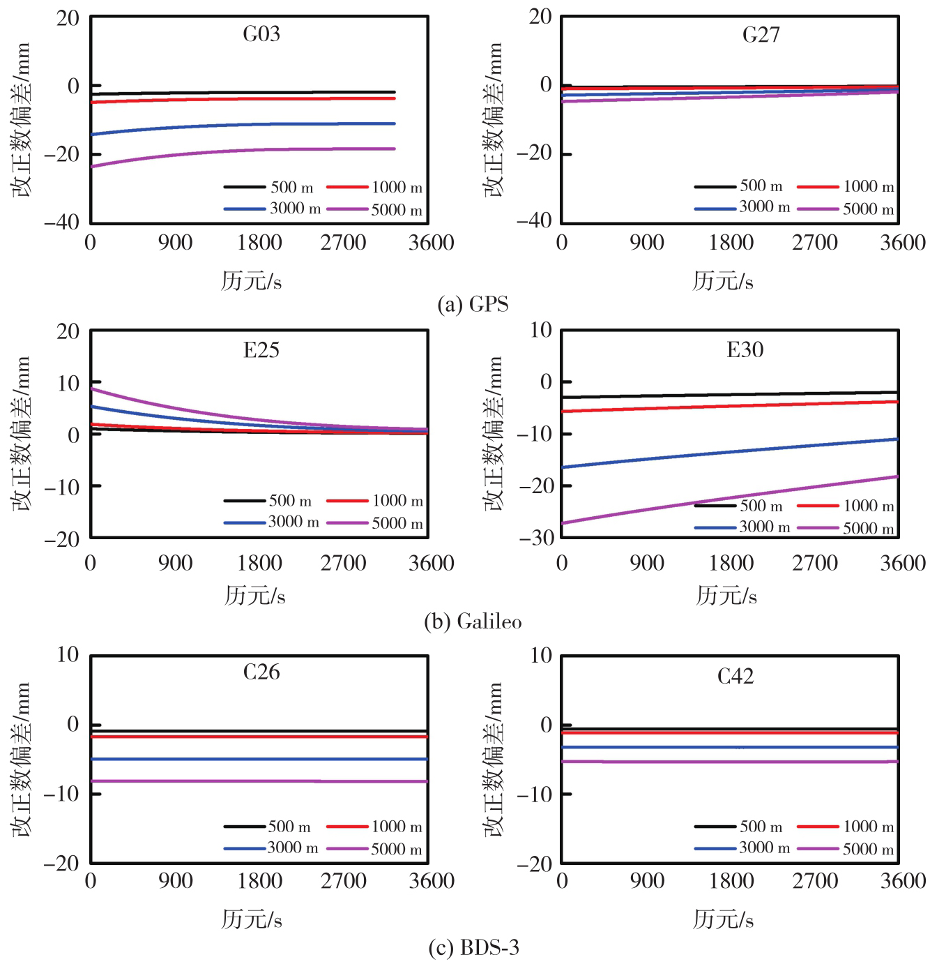
表9
非差误差改正数RMS的变化"
| 卫星 | RMS | |||||
|---|---|---|---|---|---|---|
| 100 m | 500 m | 1000 m | 2000 m | 3000 m | 5000 m | |
| G03 | 1.19 | 2.13 | 4.08 | 7.54 | 11.85 | 19.61 |
| G27 | 0.16 | 0.39 | 0.71 | 1.32 | 2.01 | 3.31 |
| E25 | 0.14 | 0.39 | 0.72 | 1.35 | 2.04 | 3.36 |
| E30 | 1.21 | 2.43 | 4.62 | 7.93 | 13.37 | 22.12 |
| C26 | 0.43 | 0.89 | 1.70 | 3.45 | 4.92 | 8.13 |
| C42 | 0.35 | 0.59 | 1.12 | 2.47 | 3.22 | 5.32 |
图12
参考站不同偏置距离的用户坐标"
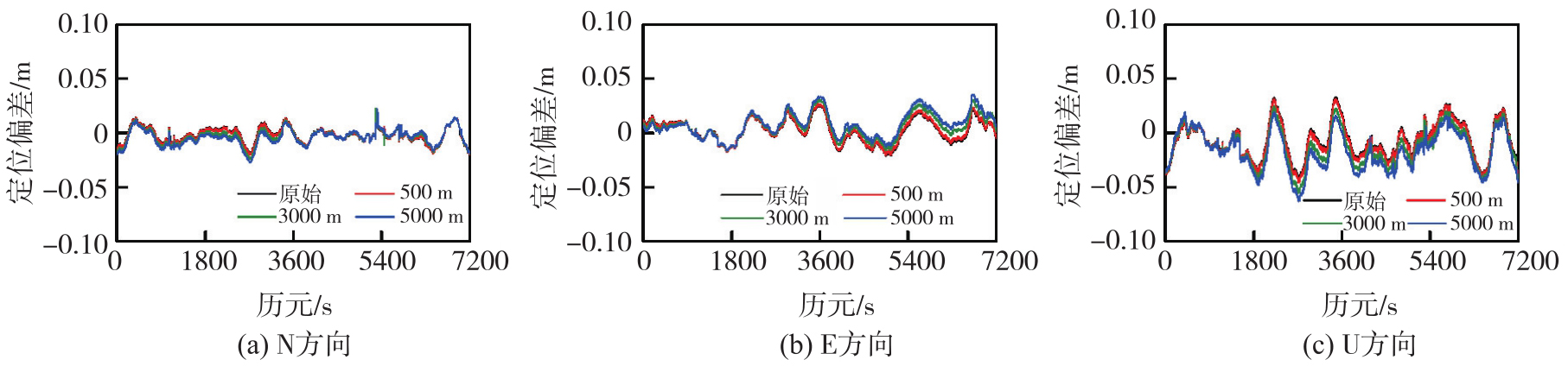
图13
参考站不同偏置距离的用户定位精度偏差RMS"
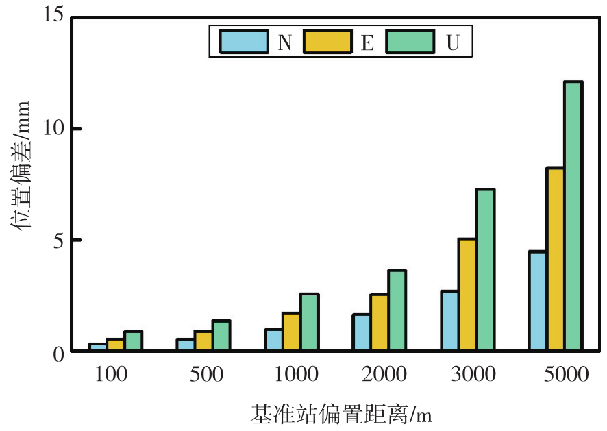
表10
用户站定位差值的变化"
| RMS | N/mm | E/mm | U/mm | 收敛速度差异/s |
|---|---|---|---|---|
| 100 m | 0.31 | 0.54 | 0.87 | 0 |
| 500 m | 0.52 | 0.89 | 1.36 | 0 |
| 1 000 m | 0.96 | 1.71 | 2.57 | 1 |
| 2 000 m | 1.64 | 2.53 | 3.61 | 1 |
| 3 000 m | 2.68 | 5.04 | 7.28 | 1 |
| 5 000 m | 4.46 | 8.25 | 12.12 | 2 |
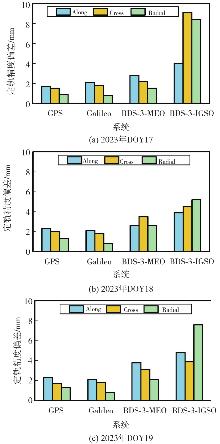
图14
定轨偏差统计"
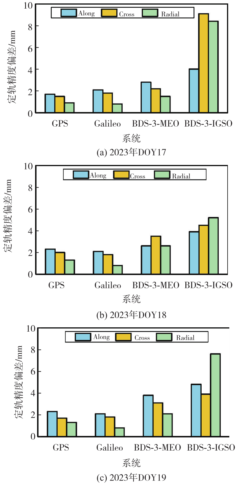
表11
参考站位置偏置对定轨精度的影响统计值"
| 日期 | 系统 | 3D-mean | Along | Cross | Radial |
|---|---|---|---|---|---|
| 2023年DOY17 | GPS | 1.4 | 1.7 | 1.5 | 0.9 |
| Galileo | 1.9 | 2.1 | 1.8 | 0.8 | |
| BDS-3-MEO | 2.3 | 2.8 | 2.2 | 1.5 | |
| BDS-3-IGSO | 7.7 | 4.0 | 9.1 | 8.4 | |
| 2023年DOY18 | GPS | 2.0 | 2.3 | 2.0 | 1.3 |
| Galileo | 1.9 | 2.1 | 1.8 | 0.8 | |
| BDS-3-MEO | 4.3 | 2.6 | 3.5 | 2.6 | |
| BDS-3-IGSO | 4.8 | 3.9 | 4.5 | 5.2 | |
| 2023年DOY19 | GPS | 1.9 | 2.3 | 1.7 | 1.3 |
| Galileo | 1.9 | 2.1 | 1.8 | 0.8 | |
| BDS-3-MEO | 3.2 | 3.8 | 3.1 | 2.1 | |
| BDS-3-IGSO | 5.7 | 4.8 | 3.9 | 7.6 |
| [1] | 刘经南, 刘晖. 建立我国卫星定位连续运行站网的若干思考[J]. 武汉大学学报(信息科学版), 2003, 28(S1): 27-31. |
| Liu Jingnan, Liu Hui. Thought on establishing a continuous operational reference station network in China[J]. Geomatics and Information Science of Wuhan University, 2003, 28(S1): 27-31. | |
| [2] | 李健, 吕志平, 乔书波. 连续运行参考站网的演化与发展趋势[J]. 测绘科学, 2008, 33(S1): 44-46. |
| Li Jian, Lü Zhiping, Qiao Shubo. Concept, evolvement and tendency of CORS[J]. Science of Surveying and Mapping, 2008, 33(S1): 44-46. | |
| [3] |
姜卫平. 卫星导航定位基准站网的发展现状、机遇与挑战[J]. 测绘学报, 2017, 46(10): 1379-1388. DOI: .
doi: 10.11947/j.AGCS.2017.20170424 |
|
Jiang Weiping. Challenges and opportunities of GNSS reference station network[J]. Acta Geodaetica et Cartographica Sinica, 2017, 46(10): 1379-1388. DOI: .
doi: 10.11947/j.AGCS.2017.20170424 |
|
| [4] |
沈飞. 采用非差模型的区域连续运行参考站网地学应用方法研究[J]. 测绘学报, 2020, 49(8): 1072. DOI: .
doi: 10.11947/j.AGCS.2020.20200152 |
|
Shen Fei. Research on regional CORS applications in geoscience using undifferenced precise point positioning[J]. Acta Geodaetica et Cartographica Sinica, 2020, 49(8): 1072. DOI: .
doi: 10.11947/j.AGCS.2020.20200152 |
|
| [5] | Tang Weiming, Liu Wenjian, Zou Xuan, et al. Improved ambiguity resolution for URTK with dynamic atmosphere constraints[J]. Journal of Geodesy, 2016, 90(12): 1359-1369. |
| [6] | Zou Xuan, Wang Yawei, Deng Chenlong, et al. Instantaneous BDS+GPS undifferenced NRTK positioning with dynamic atmospheric constraints[J]. GPS Solutions, 2017, 22(1): 17. |
| [7] | Odijk D, Zhang Baocheng, Khodabandeh A, et al. On the estimability of parameters in undifferenced, uncombined GNSS network and PPP-RTK user models by means of S-system theory[J]. Journal of Geodesy, 2016, 90(1): 15-44. |
| [8] | Li Zhao, Chen Wu, Ruan Rengui, et al. Evaluation of PPP-RTK based on BDS-3/BDS-2/GPS observations: a case study in Europe[J]. GPS Solutions, 2020, 24(2): 38. |
| [9] | Zhang Baocheng, Chen Yongchang, Yuan Yunbin. PPP-RTK based on undifferenced and uncombined observations: theoretical and practical aspects[J]. Journal of Geodesy, 2019, 93(7): 1011-1024. |
| [10] | 朱威, 任晓东, 张小红. 不同纬度和站间距的电离层单星模型对PPP-RTK增强定位效果分析[J]. 武汉大学学报(信息科学版), 2025, 50(11): 2381-2390. |
| Zhu Wei, Ren Xiaodong, Zhang Xiaohong. Performance of PPP-RTK enhanced by slant ionospheric model based on reference stations with different latitudes and distances[J]. Geomatics and Information Science of Wuhan University, 2025, 50(11): 2381-2390. | |
| [11] | 自然资源部. 自然资源部举行12月份例行新闻发布会[EB/OL]. (2025-12-30) [2026-04-26]. http://www.scio.gov.cn/xwfb/bwxwfb/gbwfbh/zrzyb/202601/t20260104_944629.html. |
| Ministry of Natural Resources of China. The Ministry of Natural Resources held a regular press conference in December[EB/OL]. (2025-12-30) [2026-04-26]. http://www.scio.gov.cn/xwfb/bwxwfb/gbwfbh/zrzyb/202601/t20260104_944629.html. | |
| [12] | 徐彦田, 窦世标, 刘艳辉, 等. 我国GNSS基准站空间分布特征分析[J]. 测绘科学, 2023, 48(6): 33-37, 72. |
| Xu Yantian, Dou Shibiao, Liu Yanhui, et al. Study on the spatial distribution characteristics of GNSS reference station in China[J]. Science of Surveying and Mapping, 2023, 48(6): 33-37, 72. | |
| [13] | 国家市场监督管理总局, 国家标准化管理委员会. GB/T 44977—2024 卫星导航定位基准站网终端定位服务安全技术规范[S]. 北京: 中国标准出版社, 2024. |
| State Administration for Market Regulation, Standardization Administration of China. GB/T 44977—2024 Specification for security of positioning service terminal of reference stations using global navigation satellite system[S]. Beijing: Standards Press of China, 2024. | |
| [14] | Brandl M, Chen X M, Landau H, et al. Anatomy of a centimeter-level precise point positioning service[J]. GPS World, 2019, 30(5): 28-35. |
| [15] | 张伟, 王林. 城市CORS系统加密转换参数的研究与应用[J]. 全球定位系统, 2022, 47(3): 46-50. |
| Zhang Wei, Wang Lin. Research and application of encryption conversion parameters in urban CORS system[J]. GNSS World of China, 2022, 47(3): 46-50. | |
| [16] | 程鹏飞, 蔡艳辉, 徐彦田. 一种GNSS原始观测数据变换方法: CN201710369236.6[P]. 2018-06-15. |
| Cheng Pengfei, Cai Yanhui, Xu Yantian. A GNSS original observation data transformation method: CN201710369236.6[P]. 2018-06-15. | |
| [17] | 姜益昊, 陶钧, 杨超, 等. GNSS基准站原始观测数据的一种虚拟化算法[J]. 测绘地理信息, 2020, 45(5): 29-34. |
| Jiang Yihao, Tao Jun, Yang Chao, et al. A virtualization algorithm for raw observation data of GNSS base station[J]. Journal of Geomatics, 2020, 45(5): 29-34. | |
| [18] | 石波, 王云鹏, 李太恒. 基准站观测数据加密方法及其在差分GNSS后处理中的应用[J]. 武汉大学学报(信息科学版), 2018, 43(5): 651-657. |
| Shi Bo, Wang Yunpeng, Li Taiheng. A densification method for base station observation data and its application to post processing of differential GNSS[J]. Geomatics and Information Science of Wuhan University, 2018, 43(5): 651-657. | |
| [19] | Wanninger L. Virtual reference stations (VRS)[J]. GPS Solutions, 2003, 7(2): 143-144. |
| [20] |
黄丁发, 冯威, 李剑锋, 等. 高精度实时位置服务的格网化VRS技术[J]. 测绘学报, 2022, 51(8): 1717-1724. DOI: .
doi: 10.11947/j.AGCS.2022.20210435 |
|
Huang Dingfa, Feng Wei, Li Jianfeng, et al. Grid VRS technique of real time high-precision location-based service[J]. Acta Geodaetica et Cartographica Sinica, 2022, 51(8): 1717-1724. DOI: .
doi: 10.11947/j.AGCS.2022.20210435 |
|
| [21] |
周锋, 徐天河. GPS/BDS/Galileo三频精密单点定位模型及性能分析[J]. 测绘学报, 2021, 50(1): 61-70. DOI: .
doi: 10.11947/J.AGCS.2021.20200146 |
|
Zhou Feng, Xu Tianhe. Modeling and assessment of GPS/BDS/Galileo triple-frequency precise point positioning[J]. Acta Geodaetica et Cartographica Sinica, 2021, 50(1): 61-70. DOI: .
doi: 10.11947/J.AGCS.2021.20200146 |
|
| [22] |
李军, 祝会忠, 刘智强. 北斗长距离参考站网模糊度固定中电离层参数的优化方法[J]. 测绘学报, 2025, 54(2): 221-232. DOI: .
doi: 10.11947/j.AGCS.2025.20240270 |
|
Li Jun, Zhu Huizhong, Liu Zhiqiang. An optimization method for ionospheric parameters in ambiguity resolution of BDS long-range reference station network[J]. Acta Geodaetica et Cartographica Sinica, 2025, 54(2): 221-232. DOI: .
doi: 10.11947/j.AGCS.2025.20240270 |
|
| [23] | 祝会忠, 郑人维, 张凯, 等. BDS/GPS非差误差改正数的实时动态定位方法[J]. 测绘科学, 2021, 46(1): 15-23. |
| Zhu Huizhong, Zheng Renwei, Zhang Kai, et al. The method of BDS/GPS real time kinematic non-difference error correction[J]. Science of Surveying and Mapping, 2021, 46(1): 15-23. | |
| [24] | 黄丁发, 李成钢, 吴耀强, 等. GPS/VRS实时网络改正数生成算法研究[J]. 测绘学报, 2007, 36(3): 256-261, 339. |
| Huang Dingfa, Li Chenggang, Wu Yaoqiang, et al. Study of the real-time network correction generation approach for GPS/VRS technique[J]. Acta Geodaetica et Cartographica Sinica, 2007, 36(3): 256-261, 339. | |
| [25] | 姚长虹. GPS卫星位置解算算法研究[J]. 科学技术与工程, 2010, 10(8): 1915-1918. |
| Yao Changhong. Research on GPS position calculation arithmetic[J]. Science Technology and Engineering, 2010, 10(8): 1915-1918. | |
| [26] | Schaffrin B, Bock Y. A unified scheme for processing GPS dual-band phase observations[J]. Bulletin Géodésique, 1988, 62(2): 142-160. |
| [27] | Li Jun, Zhu Huizhong, Xu Aigong, et al. Estimating ionospheric power spectral density for long-range RTK positioning using uncombined observations[J]. GPS Solutions, 2023, 27(3): 109. |
| [28] | Jiang Chunhua, Chen Shaoni, Wang Shuaimin, et al. A grid model of direct conversion between zenith tropospheric delay and precipitable water vapor in tropical regions[J]. GPS Solutions, 2024, 28(3): 127. |
| [29] | Niell A E. Global mapping functions for the atmosphere delay at radio wavelengths[J]. Journal of Geophysical Research: Solid Earth, 1996, 101(B2): 3227-3246. |
| [30] | Boehm J, Niell A, Tregoning P, et al. Global mapping function (GMF): a new empirical mapping function based on numerical weather model data[J]. Geophysical Research Letters, 2006, 33(7): 304-307. |
| [31] | Saastamoinen J H. Atmospheric correction for the troposphere and the stratosphere in radio ranging satellites[M]//The use of artificial satellites for geodesy. Washington, D. C.: American Geophysical Union, 1972, 247-251. |
| [32] | 葛茂荣, 刘经南. GPS定位中对流层折射估计研究[J]. 测绘学报, 1996, 25(4): 285-291. |
| Ge Maorong, Liu Jingnan. The estimation methods for tropospheric delays in global positioning system[J]. Acta Geodaetica et Cartographica Sinica, 1996, 25(4): 285-291. | |
| [33] | Verhagen S, Li Bofeng, Teunissen P J G. Ps-LAMBDA: ambiguity success rate evaluation software for interferometric applications[J]. Computers & Geosciences, 2013, 54: 361-376. |
| [34] |
祝会忠. 基于非差误差改正数的长距离单历元GNSS网络RTK算法研究[J]. 测绘学报, 2015, 44(1): 116. DOI: .
doi: 10.11947/j.AGCS.2015.20140358 |
|
Zhu Huizhong. The study of GNSS network RTK algorithm between long range at single epoch using un-difference error corrections[J]. Acta Geodaetica et Cartographica Sinica, 2015, 44(1): 116. DOI: .
doi: 10.11947/j.AGCS.2015.20140358 |
|
| [35] | 唐卫明, 刘经南, 刘晖, 等. 一种GNSS网络RTK改进的综合误差内插方法[J]. 武汉大学学报(信息科学版), 2007, 32(12): 1156-1159. |
| Tang Weiming, Liu Jingnan, Liu Hui, et al. A modified combined bias interpolation method for GNSS network RTK[J]. Geomatics and Information Science of Wuhan University, 2007, 32(12): 1156-1159. | |
| [36] | 赵齐乐, 刘经南, 葛茂荣, 等. 用PANDA对GPS和CHAMP卫星精密定轨[J]. 大地测量与地球动力学, 2005, 25(2): 113-116, 122. |
| Zhao Qile, Liu Jingnan, Ge Maorong, et al. Precise orbit determination of GPS and champ satellites with panda software[J]. Journal of Geodesy and Geodynamics, 2005, 25(2): 113-116, 122. | |
| [37] | 施闯, 赵齐乐, 楼益栋, 等. 卫星导航系统综合分析处理软件PANDA及研究进展[J]. 航天器工程, 2009, 18(4): 64-70. |
| Shi Chuang, Zhao Qile, Lou Yidong, et al. PANDA: comprehensive processing software for satellite navigation systems and its research progress[J]. Spacecraft Engineering, 2009, 18(4): 64-70. |
| [1] | 舒宝, 刘晖, 王利, 张勤, 黄观文. 区域参考站网支撑的PPP和RTK一体化服务及其性能[J]. 测绘学报, 2022, 51(9): 1870-1880. |
| [2] | 黄丁发, 冯威, 李剑锋, 龚晓颖, 栗帅帅. 高精度实时位置服务的格网化VRS技术[J]. 测绘学报, 2022, 51(8): 1717-1724. |
| [3] | 祝会忠, 李军, 蔚泽然, 张凯, 徐爱功. 长距离GPS/BDS参考站网多频载波相位整周模糊度解算方法[J]. 测绘学报, 2020, 49(3): 300-311. |
| [4] | 祝会忠, 雷啸挺, 李军, 高猛, 徐爱功. BDS参考站三频整周模糊度单历元确定方法[J]. 测绘学报, 2020, 49(11): 1388-1398. |
| [5] | 李黎 龙四春 李浩军 张立亚. 利用参考站增强信息进行精密单点定位[J]. 测绘学报, 2014, 43(5): 481-485. |
| [6] | 张宝成,欧吉坤,袁运斌. 多参考站GPS网提取精密大气延迟[J]. 测绘学报, 2012, 41(4): 0-590. |
| 阅读次数 | ||||||
|
全文 |
|
|||||
|
摘要 |
|
|||||
