


测绘学报 ›› 2025, Vol. 54 ›› Issue (7): 1178-1191.doi: 10.11947/j.AGCS.2025.20250061
李鹏1,2( ), 白建博1,2(), 李振洪3, 王厚杰1,2
收稿日期:2025-02-17
修回日期:2025-05-29
出版日期:2025-08-18
发布日期:2025-08-18
通讯作者:
白建博
E-mail:pengli@ouc.edu.cn;baijianbo@stu.ouc.edu.cn
作者简介:李鹏(1984—),男,博士,副教授,研究方向为海岸带沉降监测与环境遥感。E-mail:pengli@ouc.edu.cn
基金资助:
Peng LI1,2(), Jianbo BAI1,2(), Zhenhong LI3, Houjie WANG1,2
Received:2025-02-17
Revised:2025-05-29
Online:2025-08-18
Published:2025-08-18
Contact:
Jianbo BAI
E-mail:pengli@ouc.edu.cn;baijianbo@stu.ouc.edu.cn
About author:LI Peng (1984—), male, PhD, associate professor, majors in coastal subsidence monitoring and coastal remote sensing. E-mail: pengli@ouc.edu.cn
Supported by:摘要:
海岸带地面沉降会加剧相对海平面上升,增加与洪水相关的沿海基础设施淹没和土壤盐渍化风险。山东作为中国东部沿海经济大省,其海岸线长度约占全国的1/6,但是关于该省地面沉降时空演变特征及关键驱动因素尚不清楚。本文利用2019—2022年的Sentinel-1雷达卫星遥感影像,开展了多轨道合成孔径雷达干涉测量(InSAR)时序分析工作,提出了一种适用于陆海交接区域的InSAR多图幅拼接方法,校正了不同图幅之间的系统性偏差,得到了广域一致性良好的全省地面沉降速率图,探明了多个沉降速率超过50 mm/a的快速沉降漏斗。结合Sentinel-2多光谱遥感影像、形变时间序列和主成分分析方法,揭示了非均质沉降漏斗的时空变化及其驱动因素。结果表明,地下水与煤矿开采相关的人类活动是造成山东省地面沉降的主要因素。本文期望为大范围沿海地面沉降监测和风险管理提供技术支持和科学依据,进一步提升对沿海地质灾害风险的认识。
中图分类号:
李鹏, 白建博, 李振洪, 王厚杰. 融合多轨道TS-InSAR的广域海岸带地面沉降监测及成因解析——以山东省为例[J]. 测绘学报, 2025, 54(7): 1178-1191.
Peng LI, Jianbo BAI, Zhenhong LI, Houjie WANG. Wide area coastal subsidence monitoring and driver analysis with multi tracks of TS-InSAR—a case study of Shandong province[J]. Acta Geodaetica et Cartographica Sinica, 2025, 54(7): 1178-1191.
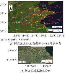
图1
本文研究区域SAR影像站点、GNSS站点与水准点分布情况"

表1
本文所用SAR影像具体参数"
| 轨道方向 | 轨道号 | 图幅号 | 影像数量 | 时间跨度 | 入射角/(°) |
|---|---|---|---|---|---|
| 升轨 | 40 | 112 | 120 | 2019-01-03—2022-12-13 | 41.61 |
| 107 | 120 | 2019-01-03—2022-12-13 | 41.64 | ||
| 142 | 121 | 119 | 2019-01-10—2022-12-20 | 41.57 | |
| 116 | 119 | 2019-01-10—2022-12-20 | 39.52 | ||
| 111 | 118 | 2019-01-10—2022-12-20 | 39.56 | ||
| 106 | 114 | 2019-02-03—2022-12-20 | 41.64 | ||
| 69 | 119 | 103 | 2019-01-05—2022-12-27 | 39.51 | |
| 114 | 104 | 2019-01-05—2022-12-27 | 39.58 | ||
| 109 | 104 | 2019-01-05—2022-12-27 | 39.57 | ||
| 171 | 121 | 105 | 2019-01-12—2022-12-22 | 41.57 | |
| 116 | 112 | 2019-01-12—2022-12-22 | 39.53 | ||
| 111 | 112 | 2019-01-12—2022-12-22 | 36.91 | ||
| 98 | 119 | 116 | 2019-01-07—2022-12-29 | 36.92 | |
| 113 | 119 | 2019-01-07—2022-12-29 | 36.92 | ||
| 降轨 | 76 | 478 | 79 | 2019-02-16—2021-12-14 | 39.70 |
| 76 | 468 | 79 | 2019-02-16—2021-12-14 | 39.64 |
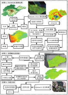
图2
技术路线"

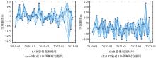
图3
干涉图时空基线网络"

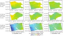
图4
主要误差改正样例"
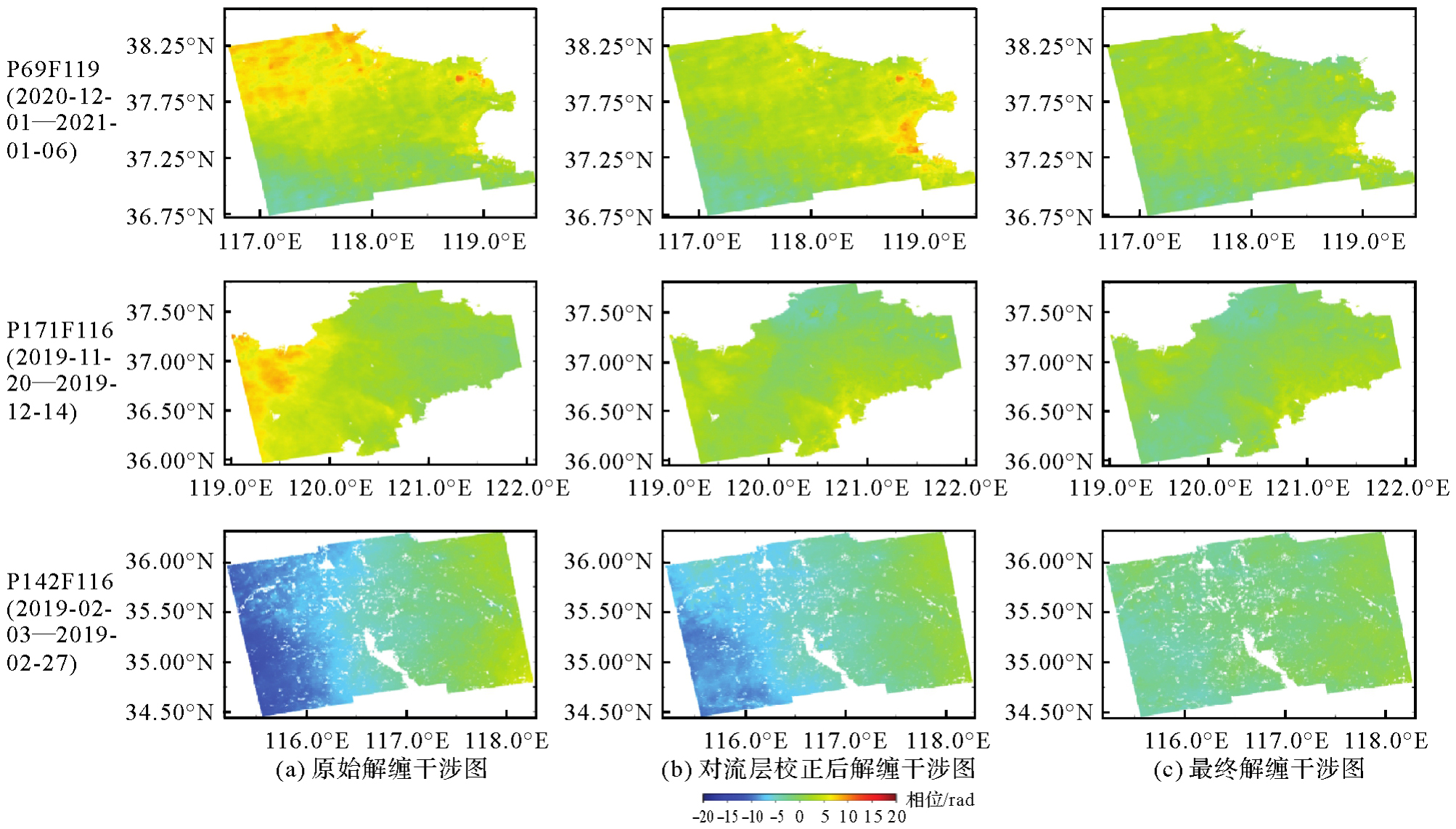
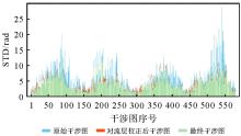
图5
改正前后干涉图相位标准差统计"
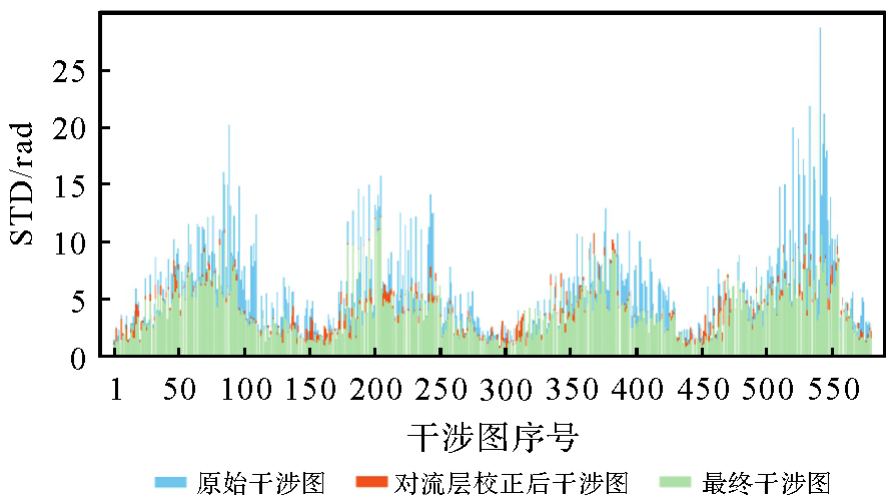
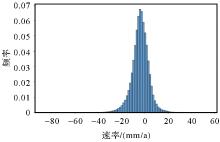
图6
频率分布直方图(以142轨道116图幅为例)"
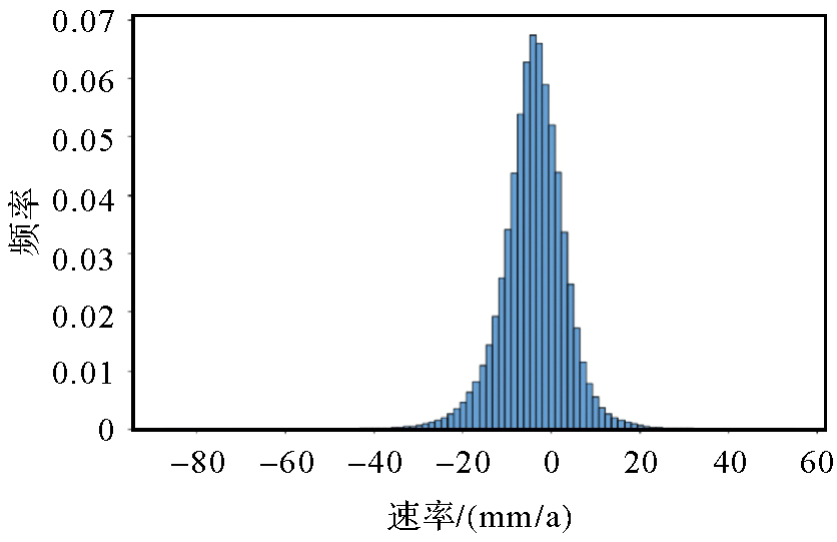
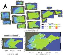
图7
各图幅和整体年均形变速率"
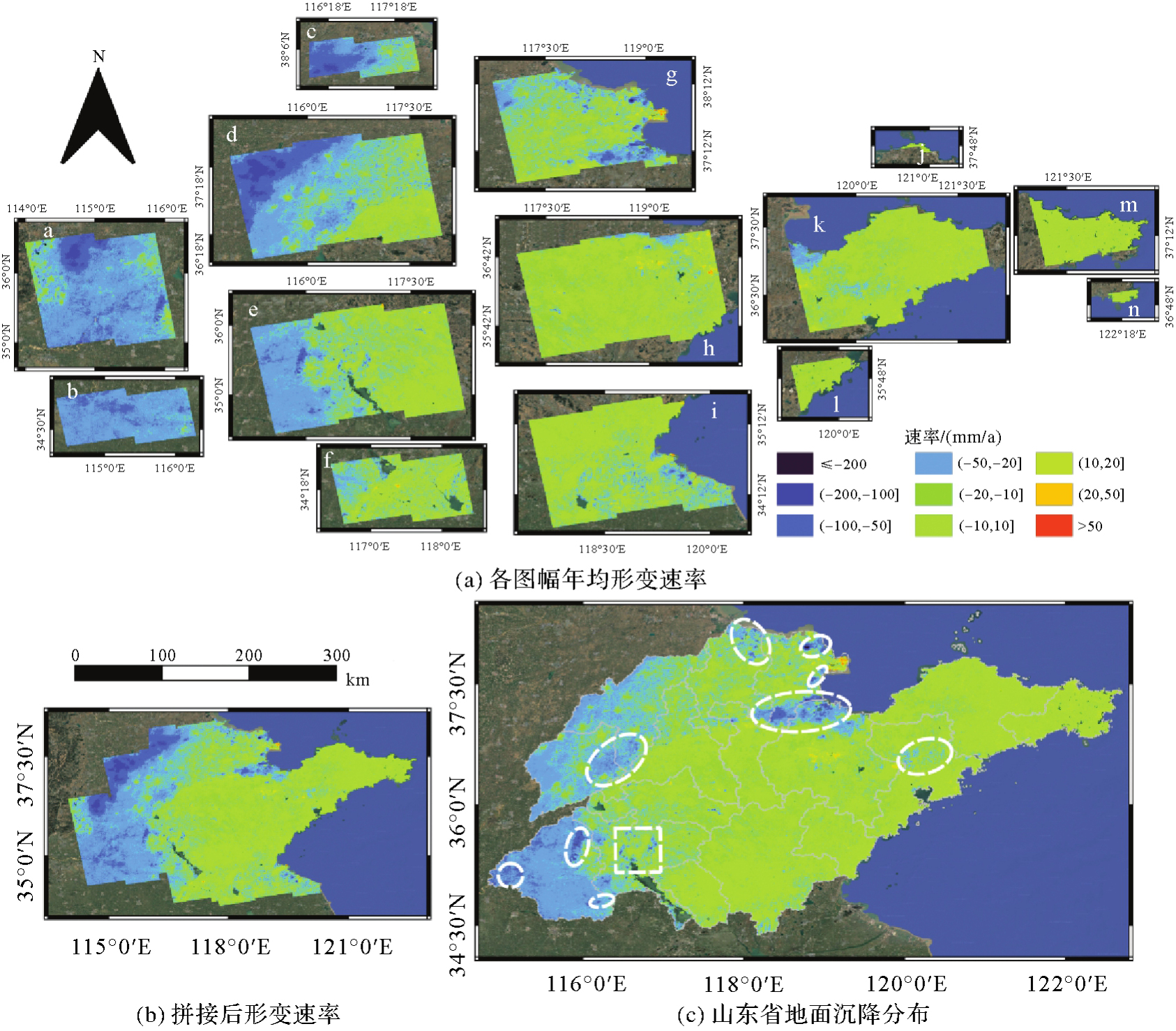
表2
图7中各子图编号、影像信息及对应的改正值"
| 子图编号 | 影像信息 | 改正值/(mm/a) | 子图编号 | 影像信息 | 改正值/(mm/a) |
|---|---|---|---|---|---|
| a | P40F112 | 0.92 | h | P69F114 | 3.76 |
| b | P40F107 | -2.08 | i | P69F109 | 1.04 |
| c | P142F121 | 4.36 | j | P171F121 | -1.86 |
| d | P142F116 | 3.21 | k | P171F116 | -3.11 |
| e | P142F111 | 2.38 | l | P171F111 | -3.22 |
| f | P142F106 | 2.95 | m | P98F119 | -3.89 |
| g | P69F119 | -0.93 | n | P98F113 | -3.54 |
图8
潍坊抬升区域的形变时序曲线"

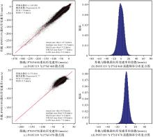
图9
升降轨结果交叉验证注:asc-des代表升降轨垂向形变速率的差值。"

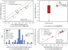
图10
时序InSAR与GNSS、水准结果对比验证"

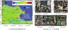
图11
山东北部沿海形变速率和沉降区域光学影像"

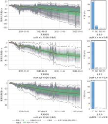
图12
沉降漏斗时序曲线和PCA各主成分"

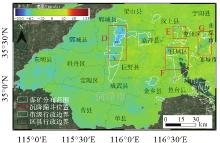
图13
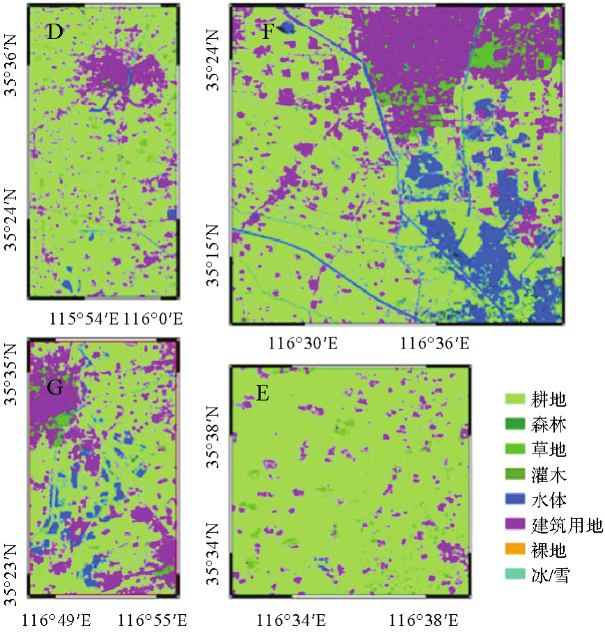
鲁西南地区形变速率"

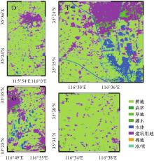
图14
图13中区域D、E、F、G的FROM-GLC10地类覆盖"
| [1] | 何秀凤, 高壮, 肖儒雅, 等. InSAR与北斗/GNSS综合方法监测地表形变研究现状与展望[J]. 测绘学报, 2022, 51(7): 1338-1355. |
| HE Xiufeng, GAO Zhuang, XIAO Ruya, et al. Application and prospect of the integration of InSAR and BDS/GNSS for land surface deformation monitoring[J]. Acta Geodaetica et Cartographica Sinica, 2022, 51(7): 1338-1355. | |
| [2] | TAY C, LINDSEY E O, CHIN S T, et al. Sea-level rise from land subsidence in major coastal cities[J]. Nature Sustainability, 2022, 5(12): 1049-1057. |
| [3] | LI Peng, WANG Guoyang, LIANG Cunren, et al. InSAR-derived coastal subsidence reveals new inundation scenarios over the Yellow River Delta[J]. IEEE Journal of Selected Topics in Applied Earth Observations and Remote Sensing, 2023, 16: 8431-8441. |
| [4] | NICHOLLS R J, LINCKE D, HINKEL J, et al. A global analysis of subsidence, relative sea-level change and coastal flood exposure[J]. Nature Climate Change, 2021, 11(4): 338-342. |
| [5] | ZHAO Qing, PEPE A, DEVLIN A, et al. Impact of sea-level-rise and human activities in coastal regions: an overview[J]. Journal of Geodesy and Geoinformation Science, 2021, 4(1): 124-143. |
| [6] | WANG Xiaolei, NIU Zijin, HE Xiufeng, et al. Monitoring of coastal subsidence changes based on GNSS positioning and GNSS-IR[J]. Journal of Geodesy and Geoinformation Science, 2023, 6(2): 71-80. |
| [7] | WANG Guoyang, LI Peng, LI Zhenhong, et al. Coastal subsidence detection and characterization caused by brine mining over the Yellow River Delta using time series InSAR and PCA[J]. International Journal of Applied Earth Observation and Geoinformation, 2022, 114: 103077. |
| [8] | WANG Guoyang, LI Peng, LI Zhenhong, et al. InSAR and machine learning reveal new understanding of coastal subsidence risk in the Yellow River Delta, China[J]. Science of the Total Environment, 2024, 915: 170203. |
| [9] | BAGHERI-GAVKOSH M, HOSSEINI S M, ATAIE-ASHTIANI B, et al. Land subsidence: a global challenge[J]. Science of The Total Environment, 2021, 778: 146193. |
| [10] | AO Zurui, HU Xiaomei, TAO Shengli, et al. A national-scale assessment of land subsidence in China's major cities[J]. Science, 2024, 384(6693): 301-306. |
| [11] |
张勤, 赵超英, 陈雪蓉. 多源遥感地质灾害早期识别技术进展与发展趋势[J]. 测绘学报, 2022, 51(6): 885-896. DOI: .
doi: 10.11947/j.AGCS.2022.20220132 |
|
ZHANG Qin, ZHAO Chaoying, CHEN Xuerong. Technical progress and development trend of geological hazards early identification with multi-source remote sensing[J]. Acta Geodaetica et Cartographica Sinica, 2022, 51(6): 885-896. DOI: .
doi: 10.11947/j.AGCS.2022.20220132 |
|
| [12] | ZHANG Yonghong, WU Hongan, LI Mingju, et al. Investigating ground subsidence and the causes over the whole Jiangsu province, China using Sentinel-1 SAR data[J]. Remote Sensing, 2021, 13(2): 179. |
| [13] | HASAN M F, SMITH R, VAJEDIAN S, et al. Global land subsidence mapping reveals widespread loss of aquifer storage capacity[J]. Nature Communications, 2023, 14(1): 6180. |
| [14] | ZHOU Lyu, ZHAO Yizhan, ZHU Zilin, et al. Spatial and temporal evolution of surface subsidence in Tianjin from 2015 to 2020 based on SBAS-InSAR technology[J]. Journal of Geodesy and Geoinformation Science, 2022, 5(1): 60-72. |
| [15] | DAI Keren, RAN Peilian, LI Zhenhong, et al. Land subsidence in Xiongan New Area, China revealed by InSAR observations[J]. Journal of Geodesy and Geoinformation Science, 2021, 4(1): 70-76. |
| [16] |
李振洪, 朱武, 余琛, 等. 影像大地测量学发展现状与趋势[J]. 测绘学报, 2023, 52(11): 1805-1834. DOI: .
doi: 10.11947/j.AGCS.2023.20230003 |
|
LI Zhenhong, ZHU Wu, YU Chen, et al. Development status and trends of imaging geodesy[J]. Acta Geodaetica et Cartographica Sinica, 2023, 52(11): 1805-1834. DOI: .
doi: 10.11947/j.AGCS.2023.20230003 |
|
| [17] |
李志伟, 许文斌, 胡俊, 等. InSAR部分地学参数反演[J]. 测绘学报, 2022, 51(7): 1458-1475. DOI: .
doi: 10.11947/j.AGCS.2022.20220156 |
|
LI Zhiwei, XU Wenbin, HU Jun, et al. Partial geoscience parameters inversion from InSAR observation[J]. Acta Geodaetica et Cartographica Sinica, 2022, 51(7): 1458-1475. DOI: .
doi: 10.11947/j.AGCS.2022.20220156 |
|
| [18] | OSMANOĞLU B, SUNAR F, WDOWINSKI S, et al. Time series analysis of InSAR data: methods and trends[J]. ISPRS Journal of Photogrammetry and Remote Sensing, 2016, 115: 90-102. |
| [19] | WU P C, WEI Meng, D'HONDT S. Subsidence in coastal cities throughout the world observed by InSAR[J]. Geophysical Research Letters, 2022, 49(7): e2022GL098477. |
| [20] | 李鹏, 李振洪, 冯万鹏, 等. 海潮负荷对沿海地区宽幅InSAR形变监测的影响[J]. 地球物理学报, 2019, 62(8): 2845-2857. |
| LI Peng, LI Zhenhong, FENG Wanpeng, et al. Impacts of ocean tidal loading on coastal deformation mapping with wide-swath InSAR observations[J]. Chinese Journal of Geophysics, 2019, 62(8): 2845-2857. | |
| [21] | 李鹏, 李振洪, 施闯, 等. 大地水准面高对InSAR大范围地壳形变监测的影响分析[J]. 地球物理学报, 2013, 56(6): 1857-1867. |
| LI Peng, LI Zhenhong, SHI Chuang, et al. Impacts of geoid height on large-scale crustal deformation mapping with InSAR observations[J]. Chinese Journal of Geophysics, 2013, 56(6): 1857-1867. | |
| [22] | YU Chen, LI Zhenhong, BAI Lin, et al. Successful applications of generic atmospheric correction online service for InSAR (GACOS) to the reduction of atmospheric effects on InSAR observations[J]. Journal of Geodesy and Geoinformation Science, 2021, 4(1): 109-115. |
| [23] | WANG Yuedong, FENG Guangcai, LI Zhiwei, et al. A multi-frame deformation velocity splicing method for wide-area InSAR measurement based on uncontrolled block adjustment: a case study of long-term deformation monitoring in Guangdong, China[J]. Remote Sensing of Environment, 2024, 301: 113929. |
| [24] |
李振洪, 朱武, 余琛, 等. 雷达影像地表形变干涉测量的机遇、挑战与展望[J]. 测绘学报, 2022, 51(7): 1485-1519. DOI: .
doi: 10.11947/j.AGCS.2022.20220224 |
|
LI Zhenhong, ZHU Wu, YU Chen, et al. Interferometric synthetic aperture radar for deformation mapping: opportunities, challenges and the outlook[J]. Acta Geodaetica et Cartographica Sinica, 2022, 51(7): 1485-1519. DOI: .
doi: 10.11947/j.AGCS.2022.20220224 |
|
| [25] | 王跃东. 广域InSAR形变监测方法研究及应用[D]. 长沙: 中南大学, 2023. |
| WANG Yuedong. Research and application of the methods for wide area InSAR deformation monitoring[D]. Changsha: Central South University, 2023. | |
| [26] | HERRERA-GARCÍA G, EZQUERRO P, TOMÁS R, et al. Mapping the global threat of land subsidence[J]. Science, 2021, 371(6524): 34-36. |
| [27] | LI Fengkai, LIU Guolin, GONG Huili, et al. Assessing land subsidence-inducing factors in the Shandong province, China, by using PS-InSAR measurements[J]. Remote Sensing, 2022, 14(12): 2875. |
| [28] | GUO Chunxi, NIE Jianliang, TIAN Jie, et al. Vertical ground displacements in the Shandong province derived from long-term GNSS and leveling surveying[J]. Advances in Space Research, 2019, 64(7): 1388-1397. |
| [29] | PENG Mimi, ZHAO Chaoying, ZHANG Qin, et al. Multi-scale and multi-dimensional time series InSAR characterizing of surface deformation over Shandong Peninsula, China[J]. Applied Sciences, 2020, 10(7): 2294. |
| [30] | WANG Dongzhen, ZHAO Bin, LI Jie, et al. Recent block kinematics and fault slip rates in the Pamir, Central Asia, from an integrated GNSS velocity field[J]. Tectonics, 2024, 43(10): e2024TC008475. |
| [31] | FATTAHI H, AGRAM P, SIMONS M. A network-based enhanced spectral diversity approach for TOPS time-series analysis[J]. IEEE Transactions on Geoscience and Remote Sensing, 2017, 55(2): 777-786. |
| [32] | ZHANG Yunjun, FATTAHI H, AMELUNG F. Small baseline InSAR time series analysis: unwrapping error correction and noise reduction[J]. Computers & Geosciences, 2019, 133: 104331. |
| [33] | 贺雪艳, 张路, BALZ Timo, 等. 利用外部DEM辅助山区SAR立体像对匹配及地形制图[J]. 测绘学报, 2013, 42(3): 425-432. |
| HE Xueyan, ZHANG Lu, BALZ T, et al. Topographic mapping in mountainous areas using StereoSAR assisted by external DEM[J]. Acta Geodaetica et Cartographica Sinica, 2013, 42(3): 425-432. | |
| [34] | CHEN C W, ZEBKER H A. Two-dimensional phase unwrapping with use of statistical models for cost functions in nonlinear optimization[J]. Journal of the Optical Society of America A, Optics, Image Science, and Vision, 2001, 18(2): 338-351. |
| [35] | ZHANG Yunjun, FATTAHI H, PI Xiaoqing, et al. Range geolocation accuracy of C-/ L-band SAR and its implications for operational stack coregistration[J]. IEEE Transactions on Geoscience and Remote Sensing, 2022, 60: 3168509. |
| [36] | YU Chen, LI Zhenhong, PENNA N T, et al. Generic atmospheric correction model for interferometric synthetic aperture radar observations[J]. Journal of Geophysical Research: Solid Earth, 2018, 123(10): 9202-9222. |
| [37] | YU Chen, LI Zhenhong, PENNA N T. Interferometric synthetic aperture radar atmospheric correction using a GPS-based iterative tropospheric decomposition model[J]. Remote Sensing of Environment, 2018, 204: 109-121. |
| [38] | YU Chen, PENNA N T, LI Zhenhong. Generation of real-time mode high-resolution water vapor fields from GPS observations[J]. Journal of Geophysical Research: Atmospheres, 2017, 122(3): 2008-2025. |
| [39] | FATTAHI H, AMELUNG F. DEM error correction in InSAR time series[J]. IEEE Transactions on Geoscience and Remote Sensing, 2013, 51(7): 4249-4259. |
| [40] | WANG Min, SHEN Zhengkang. Present-day crustal deformation of continental China derived from GPS and its tectonic implications[J]. Journal of Geophysical Research: Solid Earth, 2020, 125(2): e2019JB018774. |
| [41] | CHAUSSARD E, WDOWINSKI S, CABRAL-CANO E, et al. Land subsidence in central Mexico detected by ALOS InSAR time-series[J]. Remote Sensing of Environment, 2014, 140: 94-106. |
| [42] | 熊思婷, 曾琪明, 焦健, 等. 邻轨PS-InSAR地面沉降结果拼接处理方法与实验[J]. 地球信息科学学报, 2014, 16(5): 797-805. |
| XIONG Siting, ZENG Qiming, JIAO Jian, et al. Research on connecting PS-InSAR results from adjacent tracks for land subsidence monitoring[J]. Journal of Geo-information Science, 2014, 16(5): 797-805. | |
| [43] | COSTANTINI M, FERRETTI A, MINATI F, et al. Analysis of surface deformations over the whole Italian territory by interferometric processing of ERS, Envisat and COSMO-SkyMed radar data[J]. Remote Sensing of Environment, 2017, 202: 250-275. |
| [44] | TANG Wei, ZHAO Xiangjun, WANG Jinyang, et al. Land surface response to groundwater drawdown and recovery in Taiyuan city, Northern China, analyzed with a long-term elevation change measurements from leveling and multi-sensor InSAR[J]. Journal of Hydrology, 2024, 641: 131781. |
| [45] | LI Peng, LI Zhenhong, DAI Keren, et al. Reconstruction and evaluation of DEMs from bistatic TanDEM-X SAR in mountainous and coastal areas of China[J]. IEEE Journal of Selected Topics in Applied Earth Observations and Remote Sensing, 2021, 14: 5152-5170. |
| [46] | 王浩, 朱智勇. 广饶盐场卤水开采与地面沉降相关性研究[J]. 工程建设与设计, 2022(17): 207-210. |
| WANG Hao, ZHU Zhiyong. Study on the correlation between brine mining and ground settlement in Guangrao salt field[J]. Construction & Design for Engineering, 2022(17): 207-210. | |
| [47] | LI Gensheng, HU Zhenqi, LI Pengyu, et al. Optimal layout of underground coal mining with ground development or protection: a case study of Jining, China[J]. Resources Policy, 2022, 76: 102639. |
| [48] | 吴博, 黄文峰, 汪玉贞. 山东郓城县城区地质环境“孤岛”问题初探[J]. 城市地质, 2024, 19(3): 325-330. |
| WU Bo, HUANG Wenfeng, WANG Yuzhen. Preliminary exploration of geological environment “isolated island” problem in urban area of Yuncheng County, Shandong province[J]. Urban Geology, 2024, 19(3): 325-330. | |
| [49] |
朱建军, 杨泽发, 李志伟. InSAR矿区地表三维形变监测与预计研究进展[J]. 测绘学报, 2019, 48(2): 135-144. DOI: .
doi: 10.11947/j.AGCS.2019.20180188 |
|
ZHU Jianjun, YANG Zefa, LI Zhiwei. Recent progress in retrieving and predicting mining-induced 3D displacements using InSAR[J]. Acta Geodaetica et Cartographica Sinica, 2019, 48(2): 135-144. DOI: .
doi: 10.11947/j.AGCS.2019.20180188 |
| [1] | 高永刚, 刘雨婷, 徐涵秋. 基于Landsat长时间序列影像的城市生态品质时空演变及驱动因素分析[J]. 测绘学报, 2025, 54(3): 510-522. |
| [2] | 许兵, 朱焱, 李志伟, 易辉伟, 胡妙文, 陈琦, 韩焜, 杜洵. 国产卫星时序InSAR形变监测精度分析[J]. 测绘学报, 2024, 53(10): 1930-1941. |
| [3] | 姚朝龙, 陈涌鑫, 罗志才, 李琼, 叶雪淼, 温进杰. GNSS/GRACE/GRACE-FO/气象数据结合反演干旱指数[J]. 测绘学报, 2023, 52(11): 1883-1891. |
| [4] | 张林, 沈云中, 陈秋杰, 王奉伟. 红柳江区域陆地水储量变化及其驱动因素分析[J]. 测绘学报, 2022, 51(4): 622-630. |
| [5] | 戴可人, 沈月, 吴明堂, 冯文凯, 董秀军, 卓冠晨, 易小宇. 联合InSAR与无人机航测的白鹤滩库区蓄水前地灾隐患广域识别[J]. 测绘学报, 2022, 51(10): 2069-2082. |
| [6] | 马张烽, 蒋弥, 丁琪瑄. 时序Sentinel-1TOPS模式SAR数据精配准[J]. 测绘学报, 2021, 50(5): 634-640. |
| [7] | 何秀凤, 高壮, 肖儒雅, 罗海滨, 冯灿. 多时相Sentinel-1A InSAR的连盐高铁沉降监测分析[J]. 测绘学报, 2021, 50(5): 600-611. |
| [8] | 黄远程, 薛园园, 李朋飞. 高光谱影像子空间分析孤立森林异常目标探测方法[J]. 测绘学报, 2021, 50(3): 416-425. |
| [9] | 肖湘文, 沈校熠, 柯长青, 周兴华. 基于Sentinel-1A数据的多种机器学习算法识别冰山的比较[J]. 测绘学报, 2020, 49(4): 509-521. |
| [10] | 何华, 李宗春, 闫荣鑫, 杨再华, 阮焕立, 付永健. 引入曲面变分实现点云法矢一致性调整[J]. 测绘学报, 2018, 47(2): 275-280. |
| [11] | 黄泽纯, 张倩宁, 徐柱, 洪安东, 张瑞芳. 基于主成分变换模型的DEM格网聚合及其误差分析[J]. 测绘学报, 2017, 46(3): 389-397. |
| [12] | 董杨, 范大昭, 纪松, 雷蓉. 主成分分析的匹配点对提纯方法[J]. 测绘学报, 2017, 46(2): 228-236. |
| [13] | 王文波,赵攀,张晓东. 利用经验模态分解和主成分分析的SAR图像相干斑抑制[J]. 测绘学报, 2012, 41(6): 838-843. |
| [14] | 宦若虹 杨汝良 . 一种基于特征分类辨识的SAR图像目标检测方法[J]. 测绘学报, 2009, 38(4): 0-310. |
| 阅读次数 | ||||||
|
全文 |
|
|||||
|
摘要 |
|
|||||