


测绘学报 ›› 2025, Vol. 54 ›› Issue (11): 1917-1933.doi: 10.11947/j.AGCS.2025.20250337
• 综述 • 下一篇
童小华1,2( ), 黄荣1,2(), 曹佳瑞1, 刘宸1, 王蓉1, 徐聿升1,2, 叶真1,2, 金雁敏1,2, 刘世杰1,2, 柳思聪1,2, 冯永玖1,2, 谢欢1,2
收稿日期:2025-09-11
修回日期:2025-11-10
出版日期:2025-12-15
发布日期:2025-12-15
通讯作者:
黄荣
E-mail:xhtong@tongji.edu.cn;rong_huang@tongji.edu.cn
作者简介:童小华(1971—),男,博士,教授,博士生导师,中国工程院院士,研究方向为航天测绘遥感与深空探测。E-mail:xhtong@tongji.edu.cn
基金资助:
Xiaohua TONG1,2(), Rong HUANG1,2(), Jiarui CAO1, Chen LIU1, Rong WANG1, Yusheng XU1,2, Zhen YE1,2, Yanmin JIN1,2, Shijie LIU1,2, Sicong LIU1,2, Yongjiu FENG1,2, Huan XIE1,2
Received:2025-09-11
Revised:2025-11-10
Online:2025-12-15
Published:2025-12-15
Contact:
Rong HUANG
E-mail:xhtong@tongji.edu.cn;rong_huang@tongji.edu.cn
About author:TONG Xiaohua (1971—), male, PhD, professor, PhD supervisor, academician of Chinese Academy of Engineering, majors in space mapping and remote sensing for planetary exploration. E-mail: xhtong@tongji.edu.cn
Supported by:摘要:
地外天体的三维形貌重建是深空探测任务中的核心环节之一,为着陆区选址、巡视规划、资源勘查等提供关键的三维空间信息支撑。现有方法如摄影测量法、影像光度法与激光测高插值法等,已广泛应用于月球、火星、小行星等地外天体的三维形貌重建,在高精度地形模型构建、关键区域地貌解析及资源勘查等方面取得了显著成果。但是受制于影像获取条件受限、控制基准缺失以及地形与光照环境复杂等因素,常面临数据质量差、匹配困难、观测缺失与自动化不足等问题。近年来,卷积神经网络、生成对抗网络、注意力机制模型(Transformer)和神经辐射场等人工智能方法在地外天体的三维重建工作中被逐渐关注。本文系统回顾了人工智能方法在地外天体三维形貌重建任务中应用的3种主要技术途径,即用于影像的特征提取与匹配、用于单视影像的深度估计,以及用于多视影像的辐射场建模。本文还对各类方法的核心机制、典型应用案例、适用场景和性能特点进行了对比分析,并总结了当前存在的技术挑战,展望了未来在多源融合、自/弱监督学习、大模型及实时处理等方面的研究趋势,以期推动人工智能方法在地外天体三维形貌重建领域的进一步应用与发展。
中图分类号:
童小华, 黄荣, 曹佳瑞, 刘宸, 王蓉, 徐聿升, 叶真, 金雁敏, 刘世杰, 柳思聪, 冯永玖, 谢欢. 月球与近地行星三维形貌重建的智能方法综述:研究进展与未来挑战[J]. 测绘学报, 2025, 54(11): 1917-1933.
Xiaohua TONG, Rong HUANG, Jiarui CAO, Chen LIU, Rong WANG, Yusheng XU, Zhen YE, Yanmin JIN, Shijie LIU, Sicong LIU, Yongjiu FENG, Huan XIE. Intelligent methods for 3D terrain reconstruction of the Moon and near-Earth planets: a review of current advances and future perspectives[J]. Acta Geodaetica et Cartographica Sinica, 2025, 54(11): 1917-1933.
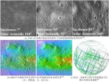
图1
地外天体三维形貌重建中的典型问题示例"

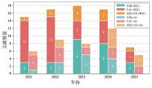
图2
近5年领域内主要期刊中现有方法与涉及人工智能方法相关论文的发表情况"
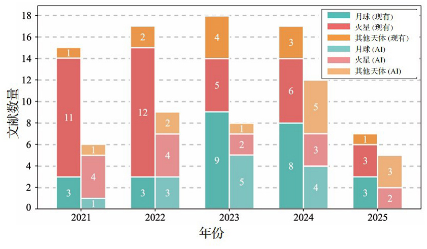
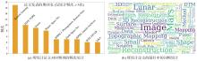
图3
本文统计论文所在期刊的频次和题目中的词频"

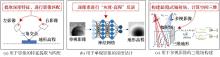
图4
地外天体三维形貌建模中3种不同技术路径的智能方法对比"

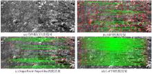
图5
现有的特征匹配方法与人工智能方法在火星CTX影像上匹配效果对比"

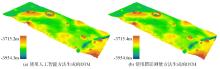
图6
基于相同分辨率的HiRISE影像,使用人工智能方法的单视影像重建[34]与使用摄影测量方法的多视影像重建(NASA)生成的DTM结果对比"
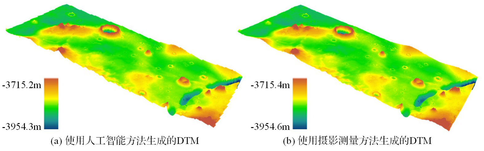
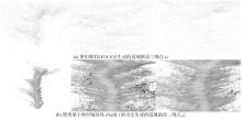
图7
基于“毅力号”巡视器获取的导航相机数据,使用现有MVS方法与神经辐射场方法[47]重建的三维点云结果对比"

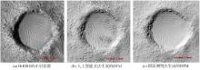
图8
使用人工智能方法[34]与使用摄影测量法(NASA)重建地形细节纹理与HiRISE正射影像的对比"

| [1] | 童小华, 刘世杰, 谢欢, 等. 从地球测绘到地外天体测绘[J]. 测绘学报, 2022, 51(4): 488-500. DOI: 10.11947/j.AGCS.2022.20220117. |
| TONG Xiaohua, LIU Shijie, XIE Huan, et al. From Earth mapping to extraterrestrial planet mapping[J]. Acta Geodaetica et Cartographica Sinica, 2022, 51(4): 488-500. DOI: 10.11947/j.AGCS.2022.20220117. | |
| [2] | 刘继忠, 胡朝斌, 庞涪川, 等. 深空探测发展战略研究[J]. 中国科学:技术科学, 2020, 50(9): 1126-1139. |
| LIU Jizhong, HU Chaobin, PANG Fuchuan, et al. Strategy of deep space exploration[J]. Scientia Sinica (Technologica), 2020, 50(9): 1126-1139. | |
| [3] | 张荣桥, 耿言, 孙泽洲, 等. 天问一号任务的技术创新[J]. 航空学报, 2022, 43(3): 626689. |
| ZHANG Rongqiao, GENG Yan, SUN Zezhou, et al. Technical innovations of the Tianwen-1 mission[J]. Acta Aeronautica et Astronautica Sinica, 2022, 43(3): 626689. | |
| [4] | 吴伟仁, 王赤, 刘洋, 等. 深空探测之前沿科学问题探析[J]. 科学通报, 2023, 68(6): 606-627. |
| WU Weiren, WANG Chi, LIU Yang, et al. Frontier scientific questions in deep space exploration[J]. Chinese Science Bulletin, 2023, 68(6): 606-627. | |
| [5] | 李春来, 刘建军, 任鑫, 等. “天问二号”任务科学目标和有效载荷配置[J]. 深空探测学报(中英文), 2024, 11(3): 304-310. |
| LI Chunlai, LIU Jianjun, REN Xin, et al. Scientific objectives and payloads configuration of the Tianwen-2 mission[J]. Journal of Deep Space Exploration, 2024, 11(3): 304-310. | |
| [6] | 裴照宇, 刘继忠, 王倩, 等. 月球探测进展与国际月球科研站[J]. 科学通报, 2020, 65(24): 2577-2586. DOI: 10.1360/TB-2020-0582. |
| PEI Zhaoyu, LIU Jizhong, WANG Qian, et al. Overview of lunar exploration and international lunar research station[J]. Chinese Science Bulletin, 2020, 65(24): 2577-2586. DOI: 10.1360/TB-2020-0582. | |
| [7] | 连丽慧, 胡腾, 康志忠, 等. 行星地质制图历史与制图体系综述[J]. 遥感学报, 2025, 29(2): 373-388. |
| LIAN Lihui, HU Teng, KANG Zhizhong, et al. A review of the history and mapping system of planetary geological mapping[J]. National Remote Sensing Bulletin, 2025, 29(2): 373-388. | |
| [8] | 邸凯昌, 刘斌, 刘召芹. 火星遥感制图技术回顾与展望[J]. 航天器工程, 2018, 27(1): 10-24. |
| DI Kaichang, LIU Bin, LIU Zhaoqin. Review and prospect of Mars mapping technique using remote sensing data[J]. Spacecraft Engineering, 2018, 27(1): 10-24. | |
| [9] | 刘洋, 吴兴, 刘正豪, 等. 火星的地质演化和宜居环境研究进展[J]. 地球与行星物理论评, 2021, 52(4): 416-436. |
| LIU Yang, WU Xing, LIU Zhenghao, et al. Geological evolution and habitable environment of Mars: progress and prospects[J]. Reviews of Geophysics and Planetary Physics, 2021, 52(4): 416-436. | |
| [10] | 柳思聪, 童小华, 刘世杰, 等. “天问一号”着陆区遥感形貌建模与制图分析[J]. 深空探测学报(中英文), 2022, 9(3): 338-347. |
| LIU Sicong, TONG Xiaohua, LIU Shijie, et al. Topography modeling, mapping and analysis of China's first Mars mission Tianwen-1 landing area from remote sensing images[J]. Journal of Deep Space Exploration, 2022, 9(3): 338-347. | |
| [11] | BOATWRIGHT B D, HEAD J W. Shape-from-shading refinement of LOLA and LROC NAC digital elevation models: applications to upcoming human and robotic exploration of the Moon[J]. The Planetary Science Journal, 2024, 5(5): 124-132. |
| [12] | WU Bo, DONG Jie, WANG Yiran, et al. Landing site selection and characterization of Tianwen-1 (Zhurong rover) on Mars[J]. Journal of Geophysical Research: Planets, 2022, 127(4): e2021JE007137. |
| [13] | CHEN Hao, WILLNER K, ZIESE R, et al. Modeling the global shape and surface morphology of the Ryugu asteroid using an improved neural implicit method[J]. Astronomy & Astrophysics, 2025, 696: A212. |
| [14] | XIE Bin, LIU Bin, DI Kaichang, et al. Robust feature matching of multi-illumination lunar orbiter images based on crater neighborhood structure[J]. Remote Sensing, 2025, 17(13): 2302. |
| [15] | MATTSON S, BOYD A, KIRK R L, et al. HiJACK: correcting space-craft jitter in HiRISE images of Mars[J]. Health Manag. Technol, 2009, 33(5): A162. |
| [16] | BLAND M T, MARTIN E S, PATTHOFF A. Increasing the usability and accessibility of Voyager 2 images of Triton[J]. The Planetary Science Journal, 2024, 5(5): 112-124. |
| [17] | LI Zhaojin, WU Bo, LIU W C, et al. Photogrammetric processing of Tianwen-1 HiRIC imagery for precision topographic mapping on Mars[J]. IEEE Transactions on Geoscience and Remote Sensing, 2022, 60: 1-16. |
| [18] | GWINNER K, SCHOLTEN F, SPIEGEL M, et al. Derivation and validation of high-resolution digital terrain models from Mars express HRSC data[J]. Photogrammetric Engineering & Remote Sensing, 2009, 75(9): 1127-1142. |
| [19] | SCHOLTEN F, OBERST J, MATZ K D, et al. GLD100: the near-global lunar 100 m raster DTM from LROC WAC stereo image data[J]. Journal of Geophysical Research: Planets, 2012, 117(E12): E00H17. |
| [20] | HENRIKSEN M R, MANHEIM M R, BURNS K N, et al. Extracting accurate and precise topography from LROC narrow angle camera stereo observations[J]. Icarus, 2017, 283: 122-137. |
| [21] | CHEN Hao, GLÄSER P, HU Xuanyu, et al. ELunarDTMNet: efficient reconstruction of high-resolution lunar DTM from single-view orbiter images[J]. IEEE Transactions on Geoscience and Remote Sensing, 2024, 62: 1-20. |
| [22] | 徐青, 耿迅, 蓝朝桢, 等. 火星地形测绘研究综述[J]. 深空探测学报, 2014, 1(1): 28-35. |
| XU Qing, GENG Xun, LAN Chaozhen, et al. Review of Mars topographic mapping[J]. Journal of Deep Space Exploration, 2014, 1(1): 28-35. | |
| [23] | GRUMPE A, BELKHIR F, WOEHLER C. Construction of lunar DEMs based on reflectance modelling[J]. Advances in Space Research, 2014, 53(12): 1735-1767. |
| [24] | LIU W C, WU Bo. Atmosphere-aware photoclinometry for pixel-wise 3D topographic mapping of Mars[J]. ISPRS Journal of Photogrammetry and Remote Sensing, 2023, 204: 237-256. |
| [25] | LI Zhaojin, WU Bo, LIU W C, et al. Integrated photogrammetric and photoclinometric processing of multiple HRSC images for pixelwise 3D mapping on Mars[J]. IEEE Transactions on Geoscience and Remote Sensing, 2021, 60: 1-13. |
| [26] | QIAN Jia, YE Zhen, QIU Siyi, et al. Secondary scattering shape from shading for precise terrain reconstruction of the lunar permanently shadowed regions[J]. Icarus, 2025, 431: 116494. |
| [27] | 欧阳自远, 肖福根. 火星及其环境[J]. 航天器环境工程, 2012, 29(6): 591-601. |
| OUYANG Ziyuan, XIAO Fugen. The Mars and its environment[J]. Spacecraft Environment Engineering, 2012, 29(6): 591-601. | |
| [28] | 凌宗成, 鞠恩明. 火星表面硫酸盐探测与研究进展[J]. 空间科学与试验学报, 2024, 24(1): 40-53. |
| LING Zongcheng, JU Enming. Research progress in the detection and investigation of sulfates on the Martian surface[J]. Journal of Space Science and Experiment, 2024, 24(1): 40-53. | |
| [29] | LIN S Y, MULLER J P, MILLS J P, et al. An assessment of surface matching for the automated co-registration of MOLA, HRSC and HiRISE DTMs[J]. Earth and Planetary Science Letters, 2010, 294(3/4): 520-533. DOI: 10.1016/j.epsl.2009.12.040. |
| [30] | XIE Huan, LIU Xiaoshuai, XU Yusheng, et al. Using laser altimetry to finely map the permanently shadowed regions of the lunar south pole using an iterative self-constrained adjustment strategy[J]. IEEE Journal of Selected Topics in Applied Earth Observations and Remote Sensing, 2022, 15: 9796-9808. |
| [31] | HUANG Rong, CHEN Chen, WAN Genyi, et al. A novel graph guided global bundle block adjustment of OSIRIS-REx laser altimeter data for topographic mapping of asteroid Bennu[J]. IEEE Transactions on Geoscience and Remote Sensing, 2024, 62: 1-14. |
| [32] | NEUMANN G A, ROWLANDS D D, LEMOINE F G, et al. Crossover analysis of Mars orbiter laser altimeter data[J]. Journal of Geophysical Research: Planets, 2001, 106(E10): 23753-23768. |
| [33] | 赵双明, 李德仁, 牟伶俐. CE-1立体相机影像与激光高度计数据不一致性分析[J]. 测绘学报, 2011, 40(6): 751-755. DOI: 10.13485/j.cnki.11-2089.2014.0178. |
| ZHAO Shuangming, LI Deren, MOU Lingli. Inconsistency analysis of CE-1 stereo camera images and laser altimeter data[J]. Acta Geodaetica et Cartographica Sinica, 2011, 40(6): 751-755. DOI: 10.13485/j.cnki.11-2089.2014.0178. | |
| [34] | CAO Jiarui, HUANG Rong, XU Yusheng, et al. LoGAN: a novel local attentive generative adversarial resizable network for detailed 3D reconstruction of the Martian surface using monocular HiRISE images and DTMs[J]. ISPRS Journal of Photogrammetry and Remote Sensing, 2025, 225: 302-327. |
| [35] | GENG Xun, XU Qing, XING Shuai, et al. A novel pixel-level image matching method for Mars express HRSC linear Pushbroom imagery using approximate orthophotos[J]. Remote Sensing, 2017, 9(12): 1262. |
| [36] | TAO Yu, MICHAEL G, MULLER J P, et al. Seamless 3D image mapping and mosaicing of valles marineris on Mars using orbital HRSC stereo and panchromatic images[J]. Remote Sensing, 2021, 13(7): 1385. |
| [37] | DETONE D, MALISIEWICZ T, RABINOVICH A. Superpoint: self-supervised interest point detection and description[C]//Proceedings of 2018 IEEE Conference on Computer Vision and Pattern Recognition Workshops. Salt Lake City: IEEE, 2018: 224-236. |
| [38] | SUN Jiaming, SHEN Zehong, WANG Yuang, et al. LoFTR: detector-free local feature matching with transformers[C]//Proceedings of 2021 IEEE/CVF Conference on Computer Vision and Pattern Recognition. Nashville: IEEE, 2021: 8922-8931. |
| [39] | CHEN Zeyu, WU Bo, LIU W C. Mars3DNet: CNN-based high-resolution 3D reconstruction of the Martian surface from single images[J]. Remote Sensing, 2021, 13(5): 839. |
| [40] | TAO Yu, XIONG Siting, CONWAY S J, et al. Rapid single image-based DTM estimation from ExoMars TGO CaSSIS images using generative adversarial U-Nets[J]. Remote Sensing, 2021, 13(15): 2877. |
| [41] | TAO Yu, MULLER J P, XIONG S T, et al. MADNet 2.0: pixel-scale topography retrieval from single-view orbital imagery of Mars using deep learning[J]. Remote Sensing, 2021, 13(21): 4220. |
| [42] | CHEN Hao, HU Xuanyu, GLÄSER P, et al. CNN-based large area pixel-resolution topography retrieval from single-view LROC NAC images constrained with SLDEM[J]. IEEE Journal of Selected Topics in Applied Earth Observations and Remote Sensing, 2022, 15: 9398-9416. |
| [43] | LI Zhaojin, WU Bo, CHEN Shihan. 3D Gaussian splatting for detailed reconstruction of planetary surfaces from orbiter images[C]//Proceedings of 2025 EGU General Assembly. Vienna: [s.n.], 2025. |
| [44] | CHEN Hao, HU Xuanyu, WILLNER K, et al. Neural implicit shape modeling for small planetary bodies from multi-view images using a mask-based classification sampling strategy[J]. ISPRS Journal of Photogrammetry and Remote Sensing, 2024, 212: 122-145. |
| [45] | CHEN Min, YAN Jianguo, HUANG Xianfeng, et al. Advancements in the 3D shape reconstruction of Phobos: an analysis of shape models and future exploration directions[J]. Astronomy & Astrophysics, 2024, 684: A89. |
| [46] | GIUSTI L, GARCIA J, COZINE S, et al. MaRF: representing Mars as neural radiance fields[C]//Proceedings of 2022 European Conference on Computer Vision. Cham: Springer, 2022: 53-65. |
| [47] | HUANG Rong, LIU Chen, XIE Huan, et al. Monocular visual SLAM with adjusting neural radiance fields for 3D reconstruction in planetary environments[J]. IEEE Transactions on Geoscience and Remote Sensing, 2025, 63: 1-19. |
| [48] | TAO Yu, WALTER S H G, MULLER J P, et al. A high-resolution digital terrain model mosaic of the Mars 2020 perseverance rover landing site at Jezero crater[J]. Earth and Space Science, 2023, 10(10): e2023EA003045. |
| [49] | DOUTÉ S, JIANG Cheng. Small-scale topographical characterization of the Martian surface with in-orbit imagery[J]. IEEE Transactions on Geoscience and Remote Sensing, 2019, 58(1): 447-460. |
| [50] | BEYER R A, ALEXANDROV O, MCMICHAEL S. The Ames stereo pipeline: NASA's open source software for deriving and processing terrain data[J]. Earth and Space Science, 2018, 5(9): 537-548. |
| [1] | 李鹏, 张家涵, 汪志翰, 王厚杰, 李振洪. 潮间带地形重建方法综述:现状、挑战与趋势[J]. 测绘学报, 2026, 55(4): 571-587. |
| [2] | 王家耀, 陈琳, 程士源, 王利军, 熊思奇. 人工智能赋能地图科学数智化[J]. 测绘学报, 2026, 55(3): 381-389. |
| [3] | 叶晨鸣, 康志忠, 才谨豪, 左秉正, 邵帅, 李彦. 形态特征引导的月表地理实体实景三维建模方法[J]. 测绘学报, 2026, 55(3): 525-535. |
| [4] | 王少华, 梁浩健, 苏澄, 徐大川, 周亮, 秦昆. 耦合时空大数据和人工智能的城市设施配置优化研究进展与展望[J]. 测绘学报, 2026, 55(2): 222-235. |
| [5] | 季顺平, 刘瑾, 高建, 龚健雅. 多视影像深度学习密集匹配三维重建智能框架[J]. 测绘学报, 2025, 54(9): 1633-1646. |
| [6] | 卢一鹏, 李雨昊, 王海平, 刘缘, 董震, 杨必胜. 基于CVT空间变换的大场景多尺度隐式三维重建[J]. 测绘学报, 2025, 54(4): 702-713. |
| [7] | 李罡, 解放, 吴一凡, 卢鋆, 郭树人, 刘迎春, 宿晨庚, 杨晓珩. 深空导航技术发展展望[J]. 测绘学报, 2025, 54(3): 397-409. |
| [8] | 马威, 涂强, 潘建平, 赵立都, 涂伟, 李清泉. 桥梁实景三维高斯辐射场建模[J]. 测绘学报, 2024, 53(9): 1694-1705. |
| [9] | 魏东, 刘欣怡, 张永军. 多视影像三维线云重建技术及其智能化发展展望[J]. 测绘学报, 2024, 53(6): 1025-1036. |
| [10] | 宁晓刚, 张翰超, 张瑞倩. 遥感影像高可信智能不变检测技术框架与方法实践[J]. 测绘学报, 2024, 53(6): 1098-1112. |
| [11] | 姜三, 刘凯, 李清泉, 江万寿. 融合深度特征的无人机影像SfM重建[J]. 测绘学报, 2024, 53(2): 321-331. |
| [12] | 刘瑾, 季顺平. 深度和法线联合估计的深度学习多视密集匹配方法[J]. 测绘学报, 2024, 53(12): 2391-2403. |
| [13] | 燕琴, 顾海燕, 杨懿, 李海涛, 沈恒通, 刘世琦. 智能遥感大模型研究进展与发展方向[J]. 测绘学报, 2024, 53(10): 1967-1980. |
| [14] | 李树涛, 吴琼, 康旭东. 高光谱遥感图像本征信息分解前沿与挑战[J]. 测绘学报, 2023, 52(7): 1059-1073. |
| [15] | 曹子龙, 童小华, 许雄, 叶真, 肖长江. 基于空地影像多层级匹配的火星巡视器定位与地面验证[J]. 测绘学报, 2023, 52(4): 579-587. |
| 阅读次数 | ||||||
|
全文 |
|
|||||
|
摘要 |
|
|||||