


测绘学报 ›› 2026, Vol. 55 ›› Issue (7): 1141-1157.doi: 10.11947/j.AGCS.2026.20260043
• 人工智能的大地测量与卫星重力反演前沿 •
张诚( ), 张豹(), 姚宜斌, 朱成昌
收稿日期:2026-01-27
修回日期:2026-05-19
发布日期:2026-08-18
通讯作者:
张豹
E-mail:sgg_zhangcheng@whu.edu.cn;sggzb@whu.edu.cn
作者简介:张诚(1997—),男,博士生,研究方向为水文大地测量学。 E-mail:sgg_zhangcheng@whu.edu.cn
基金资助:
Cheng Zhang(), Bao Zhang(), Yibin Yao, Chengchang Zhu
Received:2026-01-27
Revised:2026-05-19
Published:2026-08-18
Contact:
Bao Zhang
E-mail:sgg_zhangcheng@whu.edu.cn;sggzb@whu.edu.cn
About author:Zhang Cheng (1997—), male, PhD candidate, majors in hydrogeodesy. E-mail: sgg_zhangcheng@whu.edu.cn
Supported by:摘要:
陆地水储量(TWS)是水循环与气候变化的关键指标,精确监测其变化对理解气候变暖背景下水循环变化具有重要意义。针对GRACE/GRACE-FO卫星重力产品在空间分辨率与时间连续性方面的固有局限,以及GNSS垂直地壳位移观测空间离散、噪声复杂的问题,本文提出一种基于物理信息神经网络(PINN)的TWS反演框架,该方法深度融合了GNSS成像结果与各GRACE产品,实现了从离散站点观测到连续空间场重建的范式转换。首先,基于空间成像技术将GNSS站点垂直位移序列转换为规则网格的形变场,以增强其空间连续性与水文信号刻画能力;然后,构建以时间和GNSS垂直地壳位移为输入、GRACE TWS为输出的PINN模型,并在保持参数一致的条件下,与反向传播神经网络进行对比分析;最后,引入物理信息约束后的结果表明,模型性能显著优于纯数据驱动模型,重建结果在振幅、相位及年际变化特征上与GRACE及GLDAS产品保持更高一致性。此外,动态权重策略的引入使模型在训练中能够有效平衡数据拟合与物理约束之间的关系,从而提高收敛稳定性与整体反演精度。研究证实,PINN为实现大地测量观测数据约束下的区域TWS高分辨率反演,提供了一条稳健且具有推广价值的技术路径。
中图分类号:
张诚, 张豹, 姚宜斌, 朱成昌. 基于物理信息神经网络的GNSS陆地水储量反演[J]. 测绘学报, 2026, 55(7): 1141-1157.
Cheng Zhang, Bao Zhang, Yibin Yao, Chengchang Zhu. GNSS-based terrestrial water storage inversion using physics-informed neural networks[J]. Acta Geodaetica et Cartographica Sinica, 2026, 55(7): 1141-1157.
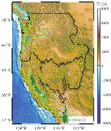
图1
研究区域地理范围及GNSS站点分布"

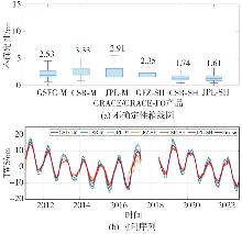
图2
多种GRACE/GRACE-FO的不确定性箱线图和时间序列"
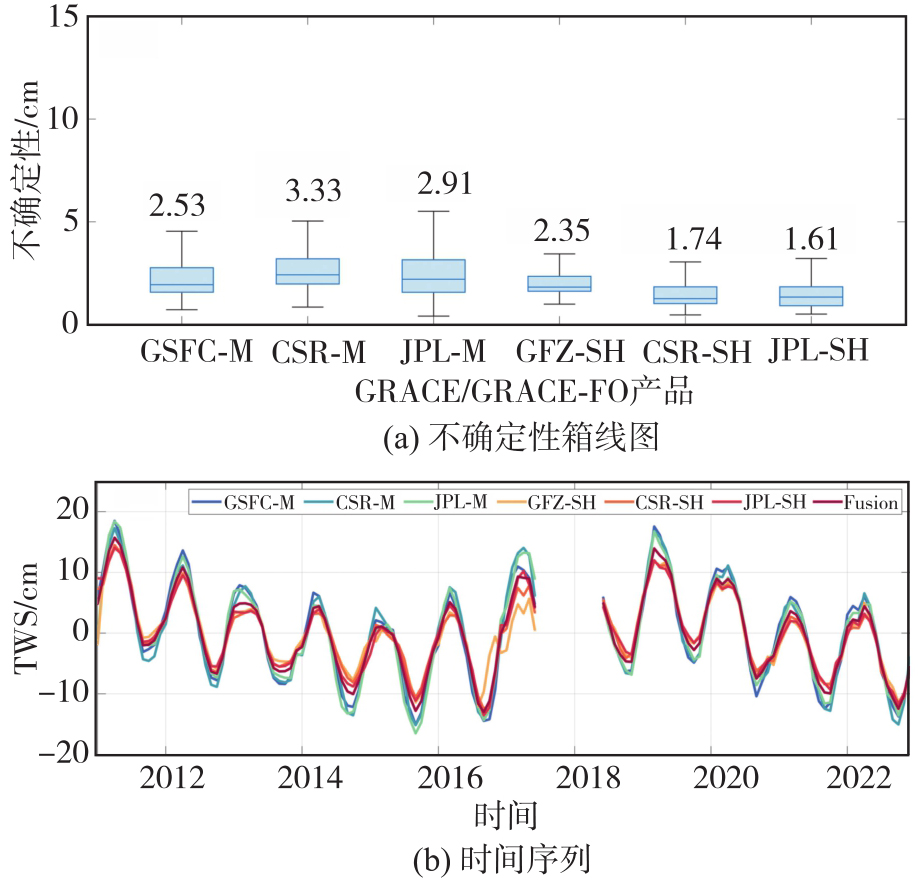
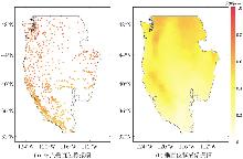
图3
GNSS站点时间序列成像前后振幅的空间分布"
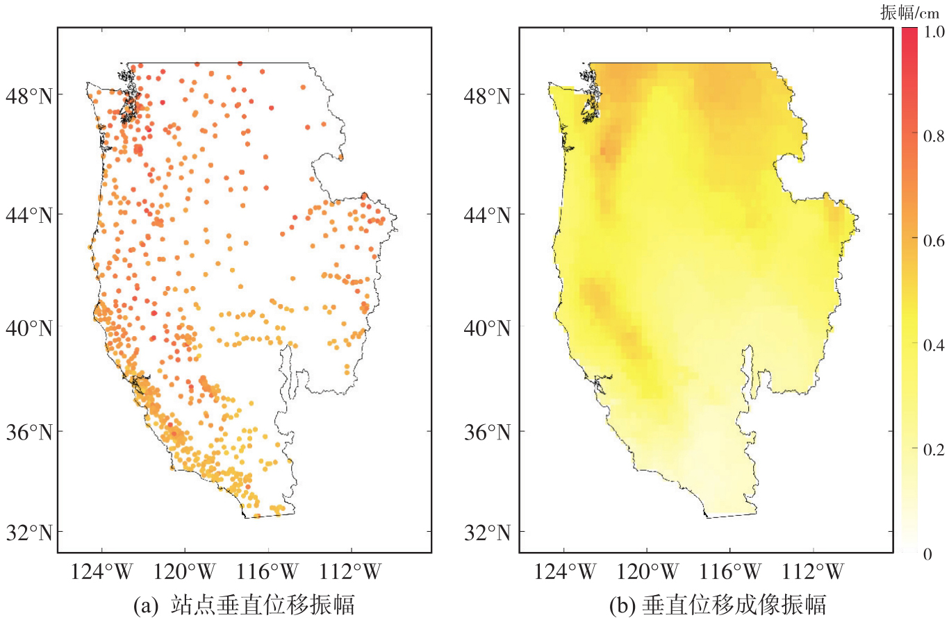
图4
物理模型约束下的神经网络框架"
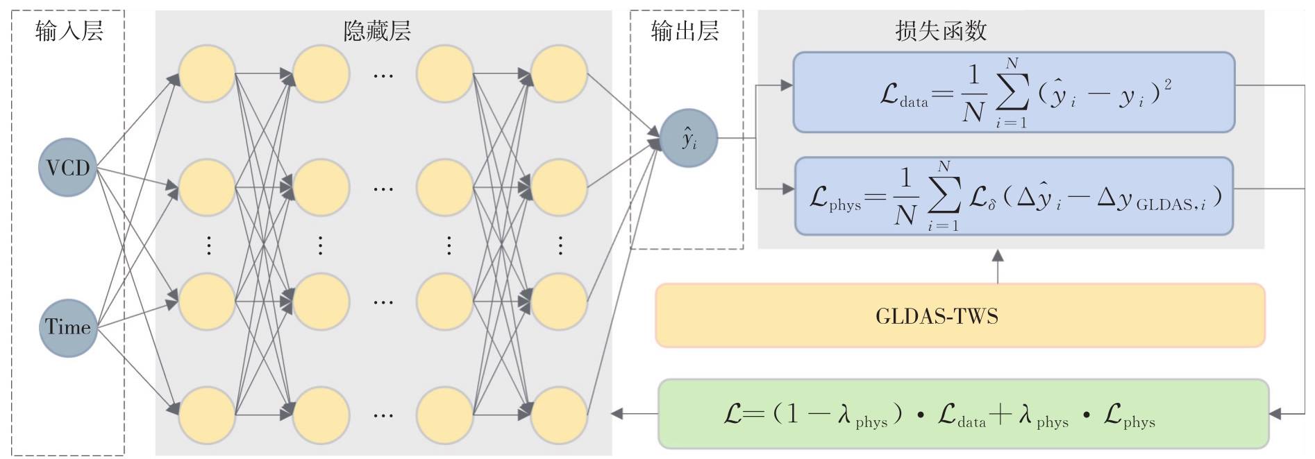
图5
PINN、BPNN和RF在全样本、训练集与测试集上的TWS重建效果"
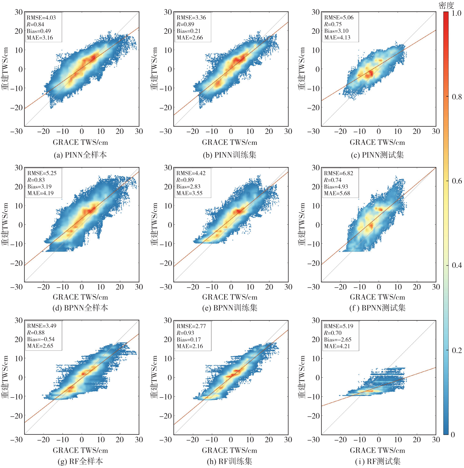

表1
PINN相对BPNN与RF的性能变化幅度"
| 数据集 | 模型 | RMSE | R | Bias | MAE |
|---|---|---|---|---|---|
| 全样本 | BPNN | 23.24 | 1.20 | 84.64 | 24.58 |
| RF | -15.47 | -4.55 | 9.26 | -19.25 | |
| 训练集 | BPNN | 23.98 | 0.00 | 92.58 | 25.07 |
| RF | -21.30 | -4.30 | -23.53 | -23.15 | |
| 测试集 | BPNN | 25.81 | 1.35 | 37.12 | 27.29 |
| RF | 2.50 | 7.14 | -16.98 | 1.90 |
图6
PINN与BPNN的TWS重建性能的空间分布"
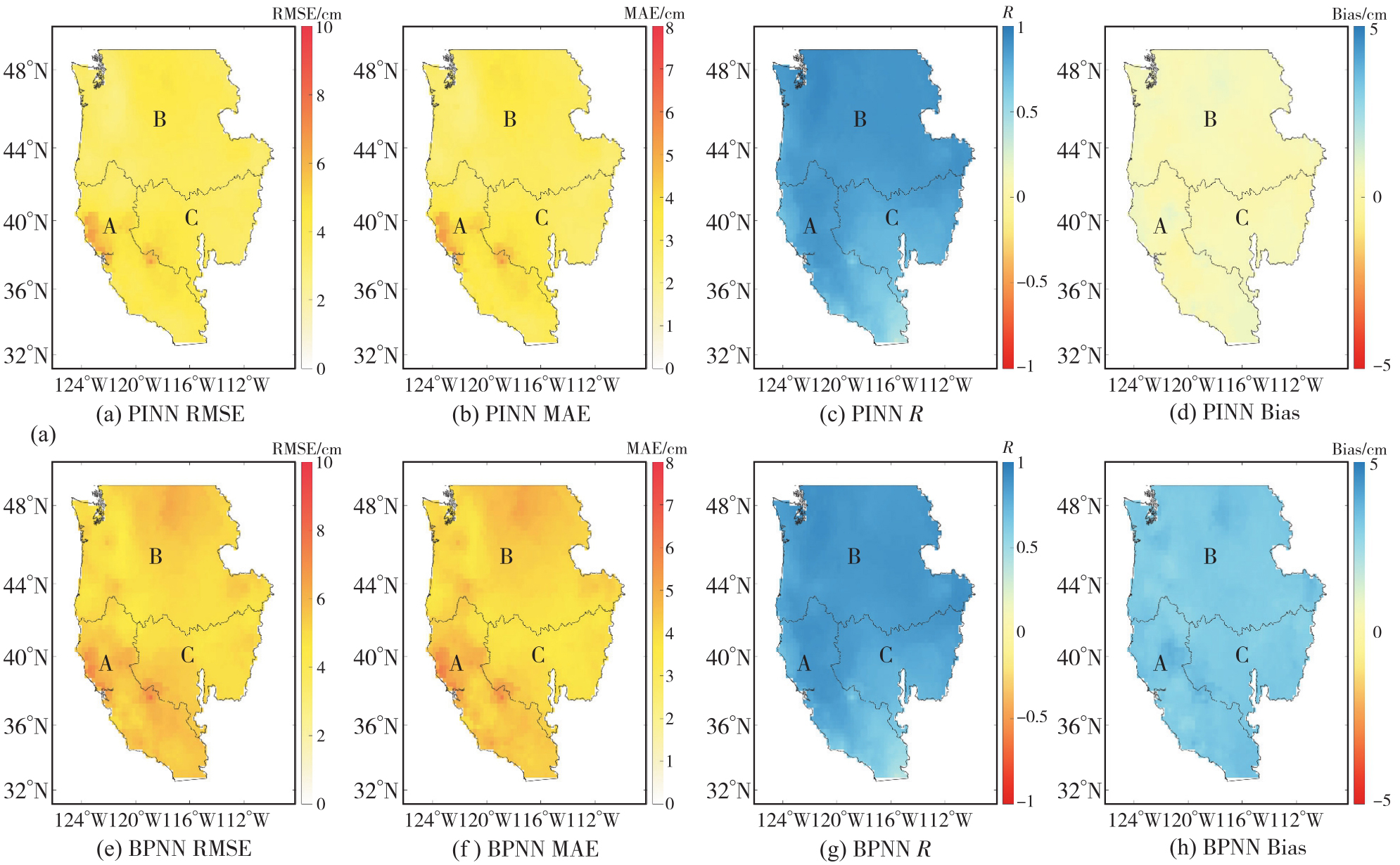
表2
子流域内PINN与BPNN精度指标平均值"
| 流域 | 模型 | RMSE/cm | MAE/cm | R | Bias/cm |
|---|---|---|---|---|---|
| 加利福尼亚 | PINN | 4.36 | 3.52 | 0.76 | 0.50 |
| 流域 | BPNN | 5.56 | 4.44 | 0.76 | 3.24 |
| 太平洋 | PINN | 3.80 | 2.99 | 0.88 | 0.49 |
| 西北流域 | BPNN | 5.12 | 4.17 | 0.87 | 3.17 |
| 大盆地 | PINN | 4.01 | 3.12 | 0.79 | 0.45 |
| 流域 | BPNN | 5.12 | 3.94 | 0.80 | 3.18 |
图7
模型重建TWS和GRACE TWS在长期趋势和振幅的空间分布"

图8
PINN与BPNN重建结果与GLDAS的一致性对比"
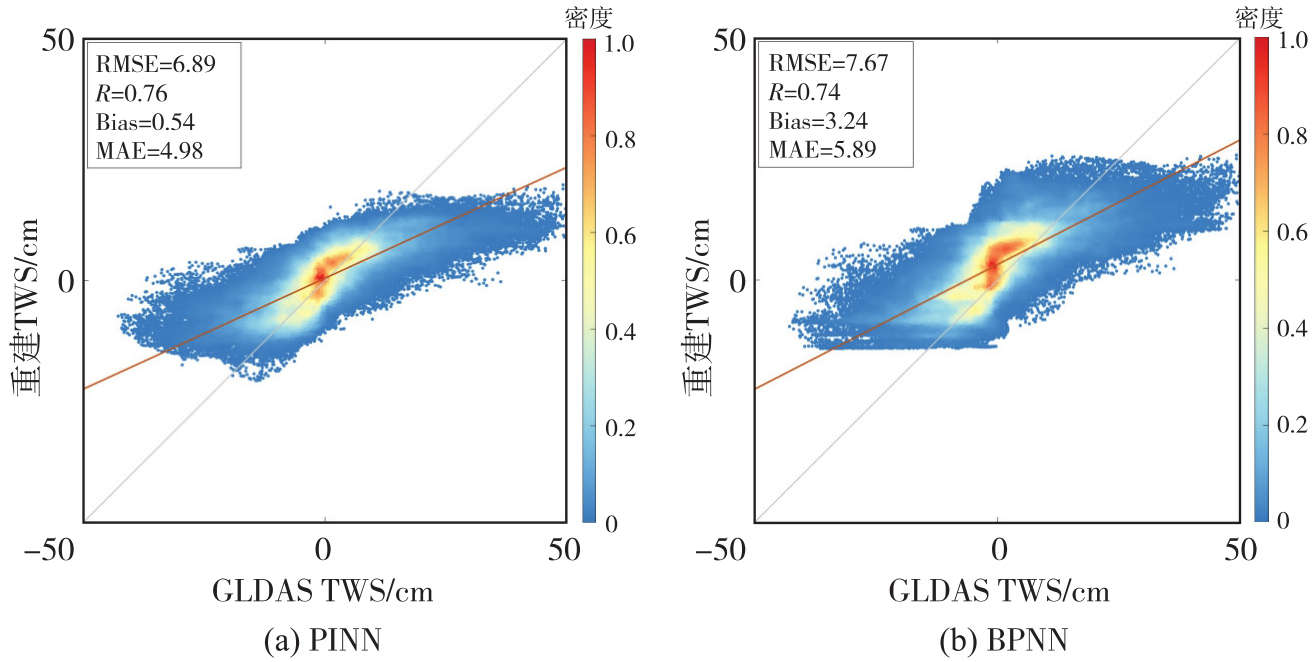
图9
研究区整体及子流域TWS时间序列对比注:灰色阴影覆盖区域为测试集时期。"
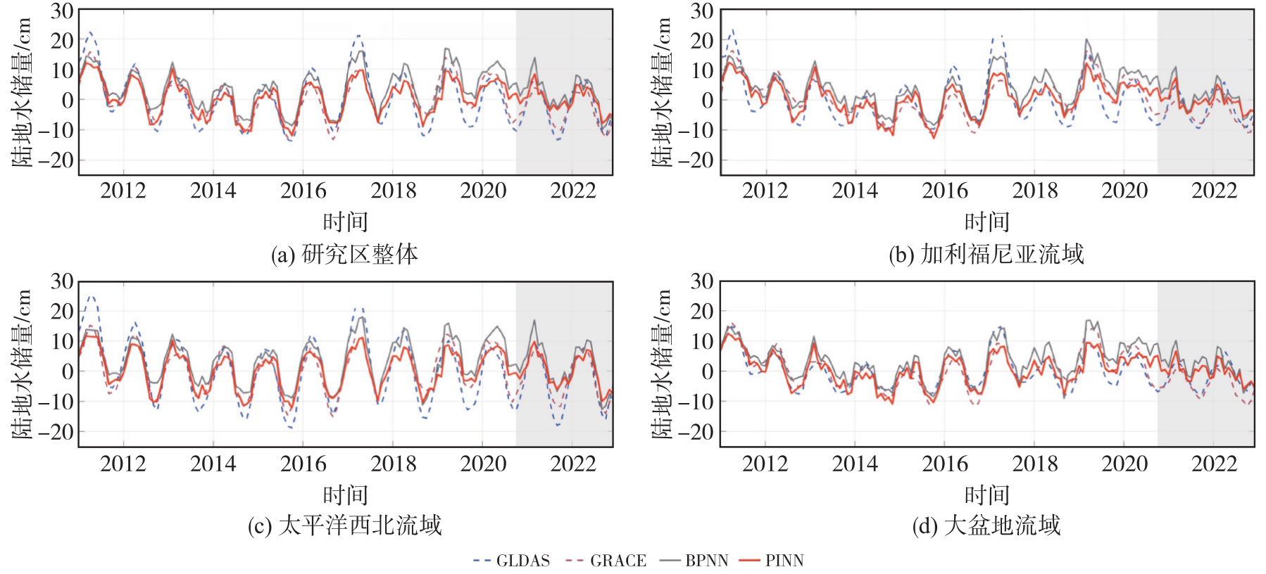
表3
GRACE分别与PINN和BPNN的RMSE"
| 模型 | 研究区整体 | 加利福尼亚流域 | 太平洋西北流域 | 大盆地流域 |
|---|---|---|---|---|
| PINN | 3.28 | 3.60 | 3.28 | 3.76 |
| BPNN | 4.50 | 4.73 | 4.62 | 4.83 |
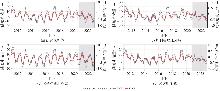
图10
研究区整体及子流域TWS与垂直地壳位移时间序列注:灰色阴影覆盖区域为测试集时期。"
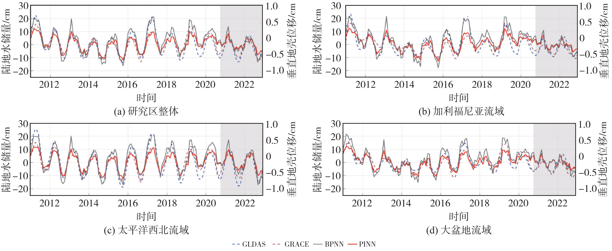
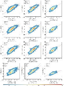
图11
不同固定物理权重下PINN重建结果与GRACE对比结果"

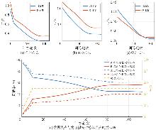
图12
PINN训练过程中损失收敛曲线和贡献率变化"
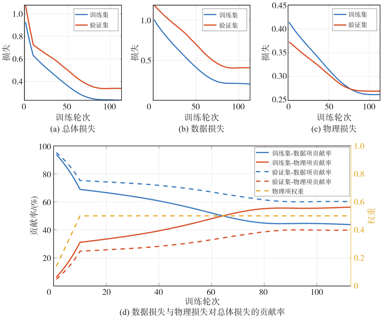
图13
TWS状态量与月变化量的原始尺度比注:柱高表示对应统计量下状态量与月变化量的比值。其中mean(|x|)为绝对值的平均值,std(x)为标准差,RMS(x)为均方根,P95(|x|)为绝对值的95%分位数。"
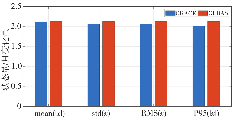
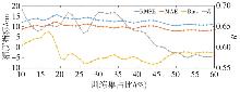
图14
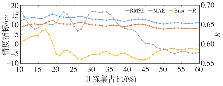
不同训练集占比下PINN与常规方法反演TWS对比"
| [1] | Rodell M, Famiglietti J S, Wiese D N, et al. Emerging trends in global freshwater availability[J]. Nature, 2018, 557(7707): 651-659. |
| [2] | 许厚泽, 陆洋, 钟敏, 等. 卫星重力测量及其在地球物理环境变化监测中的应用[J]. 中国科学(地球科学), 2012, 42(6): 843-853. |
| Xu Houze, Lu Yang, Zhong Min, et al. Satellite gravity and its application to monitoring geophysical environmental change[J]. Scientia Sinica (Terrae), 2012, 42(6): 843-853. | |
| [3] | Wahr J, Molenaar M, Bryan F. Time variability of the Earth's gravity field: hydrological and oceanic effects and their possible detection using GRACE[J]. Journal of Geophysical Research: Solid Earth, 1998, 103(B12): 30205-30229. |
| [4] | Landerer F W, Flechtner F M, Save H, et al. Extending the global mass change data record: GRACE Follow-On instrument and science data performance[J]. Geophysical Research Letters, 2020, 47(12): e2020GL088306. |
| [5] | Longuevergne L, Scanlon B R, Wilson C R. GRACE hydrological estimates for small basins: evaluating processing approaches on the High Plains Aquifer, USA[J]. Water Resources Research, 2010, 46(11): 2009WR008564. |
| [6] | Kalu I, Ndehedehe C E, Ferreira V G, et al. Machine learning assessment of hydrological model performance under localized water storage changes through downscaling[J]. Journal of Hydrology, 2024, 628: 130597. |
| [7] | Feng Wei, Xiong Yuhao, Yi Shuang, et al. Recent progress on hydrogeodesy in China[J]. Journal of Geodesy and Geoinformation Science, 2023, 6(3): 124-134. |
| [8] | Van Dam T, Wahr J, Lavallée D. A comparison of annual vertical crustal displacements from GPS and Gravity Recovery and Climate Experiment (GRACE) over Europe[J]. Journal of Geophysical Research: Solid Earth, 2007, 112(B3): 2006JB004335. |
| [9] | Blewitt G, Lavallée D. Effect of annual signals on geodetic velocity[J]. Journal of Geophysical Research: Solid Earth, 2002, 107(B7): 2145. |
| [10] | Argus D F, Peltier W R, Drummond R, et al. The Antarctica component of postglacial rebound model ICE-6G_C (VM5a) based on GPS positioning, exposure age dating of ice thicknesses, and relative sea level histories[J]. Geophysical Journal International, 2014, 198(1): 537-563. |
| [11] | Zhong Bo, Li Xianpao, Chen Jianli, et al. Estimation of terrestrial water storage changes in Brazil from the joint inversion of GRACE-based geopotential difference and GNSS vertical displacement data[J]. Water Resources Research, 2024, 60(11): e2024WR037538. |
| [12] | Karniadakis G E, Kevrekidis I G, Lu Lu, et al. Physics-informed machine learning[J]. Nature Reviews Physics, 2021, 3(6): 422-440. |
| [13] | Cuomo S, Di Cola V S, Giampaolo F, et al. Scientific machine learning through physics-informed neural networks: where we are and what's next[J]. Journal of Scientific Computing, 2022, 92(3): 88. |
| [14] | Chavoshi A, Dashtian H, Bakhshian S, et al. PINN-SM: a physics-informed neural networks model for vadose zone soil moisture profile prediction[J]. Journal of Geophysical Research: Machine Learning and Computation, 2025, 2(4): e2024JH000547. |
| [15] | Ji Yuzhe, Zha Yuanyuan, Yeh T J, et al. Groundwater inverse modeling: physics-informed neural network with disentangled constraints and errors[J]. Journal of Hydrology, 2024, 640: 131703. |
| [16] | Sakar C, Tsukanov K, Schwartz N, et al. A physics-informed neural network workflow for forward and inverse modeling of unsaturated flow and root water uptake from hydrogeophysical data[J]. Journal of Hydrology, 2026, 665: 134675. |
| [17] | Dill R, Dobslaw H. Numerical simulations of global-scale high-resolution hydrological crustal deformations[J]. Journal of Geophysical Research: Solid Earth, 2013, 118(9): 5008-5017. |
| [18] | Herring T. MATLAB Tools for viewing GPS velocities and time series[J]. GPS Solutions, 2003, 7(3): 194-199. |
| [19] | Rodell M, Houser P R, Jambor U, et al. The global land data assimilation system[J]. Bulletin of the American Meteorological Society, 2004, 85(3): 381-394. |
| [20] | Dai Yongjiu, Zeng Xubin, Dickinson Robert E, et al. The common land model[J]. Bulletin of the American Meteorological Society, 2003, 84(8): 1013-1024. |
| [21] | Huffman G J, Adler R F, Morrissey M M, et al. Global precipitation at one-degree daily resolution from multisatellite observations[J]. Journal of Hydrometeorology, 2001, 2(1): 36-50. |
| [22] | Adler R F, Huffman G J, Chang A, et al. The version-2 global precipitation climatology project (GPCP) monthly precipitation analysis (1979-present)[J]. Journal of Hydrometeorology, 2003, 4(6): 1147-1167. |
| [23] | Loomis B D, Luthcke S B, Sabaka T J. Regularization and error characterization of GRACE mascons[J]. Journal of Geodesy, 2019, 93(9): 1381-1398. |
| [24] | Antoni M. A review of different mascon approaches for regional gravity field modelling since 1968[J]. History of Geo-and Space Sciences, 2022, 13(2): 205-217. |
| [25] | Save H, Bettadpur S, Tapley B D. High-resolution CSR GRACE RL05 mascons[J]. Journal of Geophysical Research: Solid Earth, 2016, 121(10): 7547-7569. |
| [26] | Zhang Zizhan, Chao Benjamin Fong, Lu Yang, et al. An effective filtering for GRACE time-variable gravity: Fan filter[J]. Geophysical Research Letters, 2009, 36(17): L17311. |
| [27] | Swenson S, Wahr J. Post-processing removal of correlated errors in GRACE data[J]. Geophysical Research Letters, 2006, 33(8): L08402. |
| [28] | Swenson S, Chambers D, Wahr J. Estimating geocenter variations from a combination of GRACE and ocean model output[J]. Journal of Geophysical Research: Solid Earth, 2008, 113(B8): 2007JB005338. |
| [29] | Sun Yu, Riva R, Ditmar P. Optimizing estimates of annual variations and trends in geocenter motion and J2 from a combination of GRACE data and geophysical models[J]. Journal of Geophysical Research: Solid Earth, 2016, 121(11): 8352-8370. |
| [30] | Loomis B D, Rachlin K E, Wiese D N, et al. Replacing GRACE/GRACE-FO C30 with satellite laser ranging: impacts on Antarctic ice sheet mass change[J]. Geophysical Research Letters, 2020, 47(3): e2019GL085488. |
| [31] | Gray J E, Allan D W. A method for estimating the frequency stability of an individual oscillator[C]//Processings of the 28th Annual Symposium on Frequency Control. Atlantic: IEEE, 1974: 243-246. |
| [32] | 姚朝龙, 李琼, 罗志才, 等. 利用广义三角帽方法评估GRACE反演中国大陆地区水储量变化的不确定性[J]. 地球物理学报, 2019, 62(3): 883-897. |
| Yao Chaolong, Li Qiong, Luo Zhicai, et al. Uncertainties in GRACE-derived terrestrial water storage changes over mainland China based on a generalized three cornered hat method[J]. Chinese Journal of Geophysics, 2019, 62(3): 883-897. | |
| [33] | Cui Lilu, Zhu Chengkang, Wu Yunlong, et al. Natural-and human-induced influences on terrestrial water storage change in Sichuan, southwest China from 2003 to 2020[J]. Remote Sensing, 2022, 14(6): 1369. |
| [34] | Galindo F J, Palacio J. Post-processing ROA data clocks for optimal stability in the ensemble timescale[J]. Metrologia, 2003, 40(3): S237-S244. |
| [35] | Hammond W C, Blewitt G, Kreemer C. GPS imaging of vertical land motion in California and Nevada: implications for Sierra Nevada uplift[J]. Journal of Geophysical Research: Solid Earth, 2016, 121(10): 7681-7703. |
| [36] | Jiang Zhongshan, Hsu Yaju, Yuan Linguo, et al. Hydrological drought characterization based on GNSS imaging of vertical crustal deformation across the contiguous United States[J]. Science of the Total Environment, 2022, 823: 153663. |
| [37] | Raissi M, Perdikaris P, Karniadakis G E. Physics-informed neural networks: a deep learning framework for solving forward and inverse problems involving nonlinear partial differential equations[J]. Journal of Computational Physics, 2019, 378: 686-707. |
| [1] | 施闯, 陈鑫鑫, 王家乐, 夏鸣. 多源GNSS数据与深度学习驱动的智能手机RTK定位误差预测[J]. 测绘学报, 2026, 55(5): 761-775. |
| [2] | 布金伟, 刘淑慧, 徐顺双, 向彤粟, 汪秋兰, 籍超颖, 左小清. 星载GNSS-R全球海浪波周期估计的经验模型构建[J]. 测绘学报, 2026, 55(4): 684-697. |
| [3] | 李洋, 黄海军, 刘素兰, 吴晓辉, 刘琦, 庞琪沛, 吴云龙. 鄱阳湖流域未来百年陆地水储量异常预测及干旱风险评估:基于CMIP6驱动的Transformer-GRU模型[J]. 测绘学报, 2026, 55(4): 721-738. |
| [4] | 吴汤婷, 罗馨语, 卢立果, 刘站科, 超能芳. 基于GNSS和GRACE/GRACE-FO的陕甘宁地区水资源与水文干旱特征时空变化评价[J]. 测绘学报, 2026, 55(3): 439-450. |
| [5] | 马中民, 张双成, 周昕, 刘奇, 刘宁, 王恒利. 顾及地表反射率不确定性的风云三号GNSS-R洪涝监测方法:以8·2广东极端暴雨灾害为例[J]. 测绘学报, 2026, 55(3): 451-464. |
| [6] | 严清赟, 郭紫璇, 潘元进, 贾燕, 金双根. GNSS-R陆表反射率空间分异驱动因子定量分析与分区模式[J]. 测绘学报, 2026, 55(2): 315-327. |
| [7] | 赵庆志, 蒋朵朵, 姚宜斌, 马智, 马永杰, 李浩杰, 薛瑞瑞. 一种GNSS卫星信号自适应优选的水汽层析方法[J]. 测绘学报, 2026, 55(1): 25-35. |
| [8] | 余德荧, 李厚朴, 刘一, 武曙光, 李得宴, 李明超, 李文魁, 边少锋. 基于DBSCAN的多粗差识别RAIM算法[J]. 测绘学报, 2026, 55(1): 59-72. |
| [9] | 程栋梁, 陈灵秋, 黄志勇, 乔书波, 王丹丹, 闫亚明. 基于COATS的多模多频iGNSS-R测高性能评估[J]. 测绘学报, 2026, 55(1): 73-89. |
| [10] | 罗亚荣, 卢文韬, 郭迟, 刘经南. GNSS/INS组合导航左手对称性等变滤波模型及算法[J]. 测绘学报, 2025, 54(8): 1389-1403. |
| [11] | 陈洋溢, 郑凯, 张小红, 吴明魁, 王鹏旭, 付文举, 刘克中. GPS/Galileo/BDS重叠频率多路径误差分析及建模[J]. 测绘学报, 2025, 54(8): 1427-1438. |
| [12] | 李建章, 闫浩文, 杨维芳, 苏小宁. GNSS伪三角高程测量方法[J]. 测绘学报, 2025, 54(7): 1170-1177. |
| [13] | 王潜心, 胡超, 程彤. 基于GNSS钟差参数先验信息的超快速轨道钟差估计方法[J]. 测绘学报, 2025, 54(6): 982-994. |
| [14] | 沈洋, 李广云, 陈明剑, 李林阳, 施星宇, 蔡巍, 郝卫峰. 基于风云三号TEC的极区GNSS电离层模型精度评估[J]. 测绘学报, 2025, 54(6): 995-1008. |
| [15] | 范昊鹏, 张博骄, 孙中苗, 冯进凯. 基于ConvLSTM网络的区域对流层湿延迟预报方法[J]. 测绘学报, 2025, 54(5): 795-804. |
| 阅读次数 | ||||||
|
全文 |
|
|||||
|
摘要 |
|
|||||
