| [1] |
LEVERMANN A, GRIESEL A, HOFMANN M, et al. Dynamic sea level changes following changes in the thermohaline circulation[J]. Climate Dynamics, 2005, 24(4): 347-354.
|
| [2] |
ARCHER M, WANG Jinbo, KLEIN P, et al. Wide-swath satellite altimetry unveils global submesoscale ocean dynamics[J]. Nature, 2025, 640(8059): 691-696.
|
| [3] |
HALL C D, CORDEY R A. Multistatic scatterometry[C]//Proceedings of 1988 Remote Sensing: Moving Toward the 21st Century. Edinburgh: International Geoscience and Remote Sensing Symposium, 1988: 561-562.
|
| [4] |
MARTIN-NEIRA M. A passive reflectometry and interferometry system (PARIS): application to ocean altimetry[J]. ESA Journal, 1993, 17: 331-355.
|
| [5] |
GLEASON S, HODGART S, SUN Yiping, et al. Detection and processing of bistatically reflected GPS signals from low Earth orbit for the purpose of ocean remote sensing[J]. IEEE Transactions on Geoscience and Remote Sensing, 2005, 43(6): 1229-1241.
|
| [6] |
UNWIN M, JALES P, TYE J, et al. Spaceborne GNSS-Reflectometry on TechDemoSat-1: early mission operations and exploitation[J]. IEEE Journal of Selected Topics in Applied Earth Observations and Remote Sensing, 2016, 9(10): 4525-4539.
|
| [7] |
RUF C S, ATLAS R, CHANG P S, et al. New ocean winds satellite mission to probe hurricanes and tropical convection[J]. Bulletin of the American Meteorological Society, 2016, 97(3): 385-395.
|
| [8] |
JING Cheng, NIU Xinliang, LU Feng, et al. GNSS-R from the Bufeng-1 twin satellites for sea surface winds under hurricane condition[C]//Proceedings of 2021 IEEE International Geoscience and Remote Sensing Symposium. Brussels: IEEE, 2021: 1299-1302.
|
| [9] |
SUN Yueqiang, WANG Xianyi, DU Qifei, et al. The status and progress of Fengyun-3e GNOS II mission for GNSS remote sensing[C]//Proceedings of 2019 IEEE International Geoscience and Remote Sensing Symposium. Yokohama: IEEE, 2019: 5181-5184.
|
| [10] |
CHENG Zixuan, JIN Taoyong, CHANG Xin, et al. Evaluation of spaceborne GNSS-R based sea surface altimetry using multiple constellation signals[J]. Frontiers in Earth Science, 2023, 10: 1079255.
|
| [11] |
MARTIN-NEIRA M, D'ADDIO S, BUCK C, et al. The PARIS ocean altimeter in-orbit demonstrator[J]. IEEE Transactions on Geoscience and Remote Sensing, 2011, 49(6): 2209-2237.
|
| [12] |
CARDELLACH E, RIUS A, MARTÍN-NEIRA M, et al. Consolidating the precision of interferometric GNSS-R ocean altimetry using airborne experimental data[J]. IEEE Transactions on Geoscience and Remote Sensing, 2014, 52(8): 4992-5004.
|
| [13] |
LI Weiqiang, YANG Dongkai, D'ADDIO S, et al. Partial interferometric processing of reflected GNSS signals for ocean altimetry[J]. IEEE Geoscience and Remote Sensing Letters, 2014, 11(9): 1509-1513.
|
| [14] |
FABRA F, CARDELLACH E, RIBÓ S, et al. Is accurate synoptic altimetry achievable by means of interferometric GNSS-R?[J]. Remote Sensing, 2019, 11(5): 505.
|
| [15] |
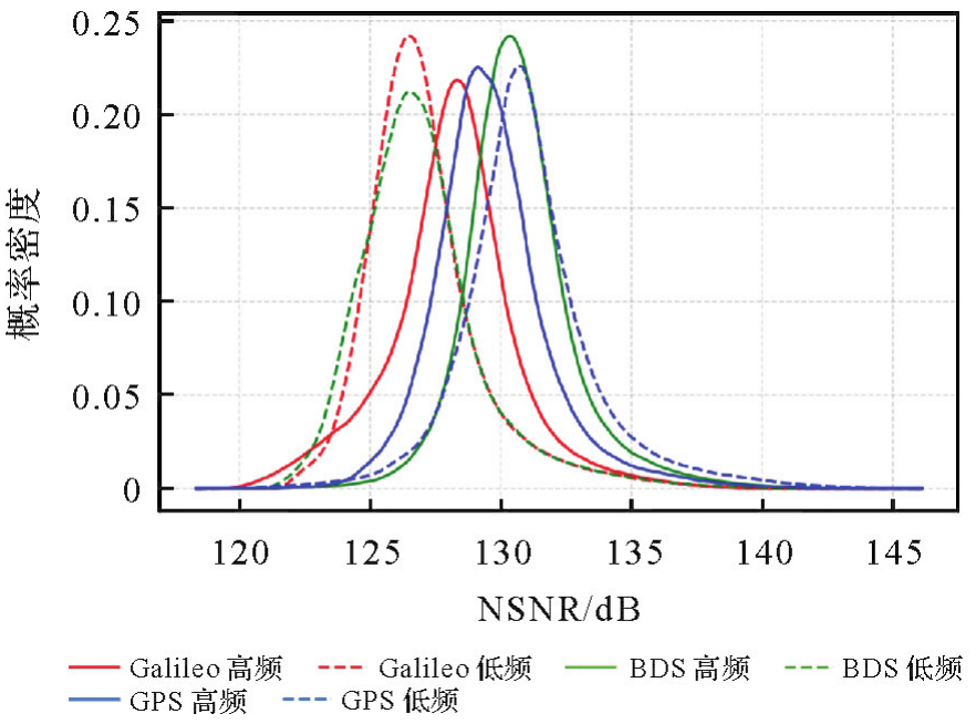
WU Xiang, GUO Bofeng, NAN Yang, et al. Characterization of full-spectrum GPS L1, Galileo E1, and BeiDou-3 B1 signals for interferometric GNSS-R ocean altimetry[J]. IEEE Transactions on Geoscience and Remote Sensing, 2025, 63: 5800511.
|
| [16] |
孙中苗, 翟振和, 管斌, 等. 双星跟飞测高卫星在轨初步验证[J]. 测绘学报, 2024(2): 207-216. DOI: .
doi: 10.11947/j.AGCS.2024.20230264
|
|
SUN Zhongmiao, ZHAI Zhenhe, GUAN Bin, et al. Preliminary verification of dual-satellite tandem altimetry on board[J]. Acta Geodaetica et Cartographica Sinica, 2024(2): 207-216. DOI: .
doi: 10.11947/j.AGCS.2024.20230264
|
| [17] |
SONG Minfeng, HE Xiufeng, WANG Xiaolei, et al. Study on the exploration of spaceborne GNSS-R raw data focusing on altimetry[J]. IEEE Journal of Selected Topics in Applied Earth Observations and Remote Sensing, 2020, 13: 6142-6154.
|
| [18] |
SAASTAMOINEN J. Atmospheric correction for the troposphere and stratosphere in radio ranging satellites[M]//HENRIKSEN S W, MANCINI A, CHOVITZ B H. Geophysical monograph series. Washington, D. C.: American Geophysical Union, 2013: 247-251.
|
| [19] |
LI Weiqiang, CARDELLACH E, FABRA F, et al. Assessment of spaceborne GNSS-R ocean altimetry performance using CYGNSS mission raw data[J]. IEEE Transactions on Geoscience and Remote Sensing, 2020, 58(1): 238-250.
|
| [20] |
HAJJ G A, ZUFFADA C. Theoretical description of a bistatic system for ocean altimetry using the GPS signal[J]. Radio Science, 2003, 38(5): 2002RS002787.
|
| [21] |
MASHBURN J, AXELRAD P, LOWE S T, et al. Global ocean altimetry with GNSS reflections from TechDemoSat-1[J]. IEEE Transactions on Geoscience and Remote Sensing, 2018, 56(7): 4088-4097.
|
| [22] |
NAN Yang, YE Shirong, LIU Jingnan, et al. Signal-to-noise ratio analyses of spaceborne GNSS-reflectometry from Galileo and BeiDou satellites[J]. Remote Sensing, 2022, 14(1): 35.
|
| [23] |
CHEW C, SHAH R, ZUFFADA C, et al. Demonstrating soil moisture remote sensing with observations from the UK TechDemoSat-1 satellite mission[J]. Geophysical Research Letters, 2016, 43(7): 3317-3324.
|
| [24] |
ANDERSEN O B, ROSE S K, ABULAITIJIANG A, et al. The DTU21 global mean sea surface and first evaluation[J]. Earth System Science Data, 2023, 15(9): 4065-4075.
|


 ), 陈灵秋1,2(