


测绘学报 ›› 2026, Vol. 55 ›› Issue (1): 90-100.doi: 10.11947/j.AGCS.2026.20250325
孙启钤1( ), 贾帅东1(), 梁志诚2, 刘现鹏1, 宋浩石1
收稿日期:2025-08-13
修回日期:2025-12-28
出版日期:2026-02-13
发布日期:2026-02-13
通讯作者:
贾帅东
E-mail:2393272126@qq.com;sky_jsd@163.com
作者简介:孙启钤(2003—),男,硕士生,研究方向为众源水深数据处理及建模。E-mail:2393272126@qq.com
基金资助:
Qiqian SUN1(), Shuaidong JIA1(), Zhicheng LIANG2, Xianpeng LIU1, Haoshi SONG1
Received:2025-08-13
Revised:2025-12-28
Online:2026-02-13
Published:2026-02-13
Contact:
Shuaidong JIA
E-mail:2393272126@qq.com;sky_jsd@163.com
About author:SUN Qiqian (2003—), male, postgraduate, majors in crowdsourced bathymetric data processing and modeling. E-mail: 2393272126@qq.com
Supported by:摘要:
针对当前方法未充分考虑众源水深数据分布不均匀、精度差异大等特点,导致所构数字水深模型(DDM)质量偏低的问题,本文提出了一种顾及众源水深数据分布与精度差异的海峡通道DDM构建方法。首先,分析原始数据分布不均匀、精度差异大对格网节点水深内插的影响机理;然后,考虑数据分布不均匀可能引起不同方向上的参考点数量存在较大差异,设计顾及原始数据分布各向异性的参考点八方向数量动态调优机制,避免传统方法因“方向性倾斜”导致内插方法稳健性差的问题;最后,以反距离加权的内插函数为基础,在函数中进一步考虑数据分布不均匀、精度差异大等因素的影响,通过引入数据精度因子、分布因子及方位因子,调和不同众源水深数据点对格网节点水深插值的贡献差异,提高格网节点的内插精度。综合试验结果表明,本文方法在DDM整体构建精度、不同海底地形适应性及方法稳健性方面均优于常规IDW和普通克里金插值等对比方法,能够更好地顾及众源水深数据特征及地形变化特征。权重因子的有效性试验进一步表明,本文方法能够更全面地刻画众源水深数据的空间特征与质量差异,从而提升DDM构建的精度与稳定性。
中图分类号:
孙启钤, 贾帅东, 梁志诚, 刘现鹏, 宋浩石. 顾及众源水深数据特征的海峡通道DDM构建方法[J]. 测绘学报, 2026, 55(1): 90-100.
Qiqian SUN, Shuaidong JIA, Zhicheng LIANG, Xianpeng LIU, Haoshi SONG. A method for constructing digital depth model of strait passage considering crowdsourced bathymetric data characteristics[J]. Acta Geodaetica et Cartographica Sinica, 2026, 55(1): 90-100.
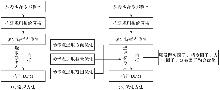
图1
基本步骤"
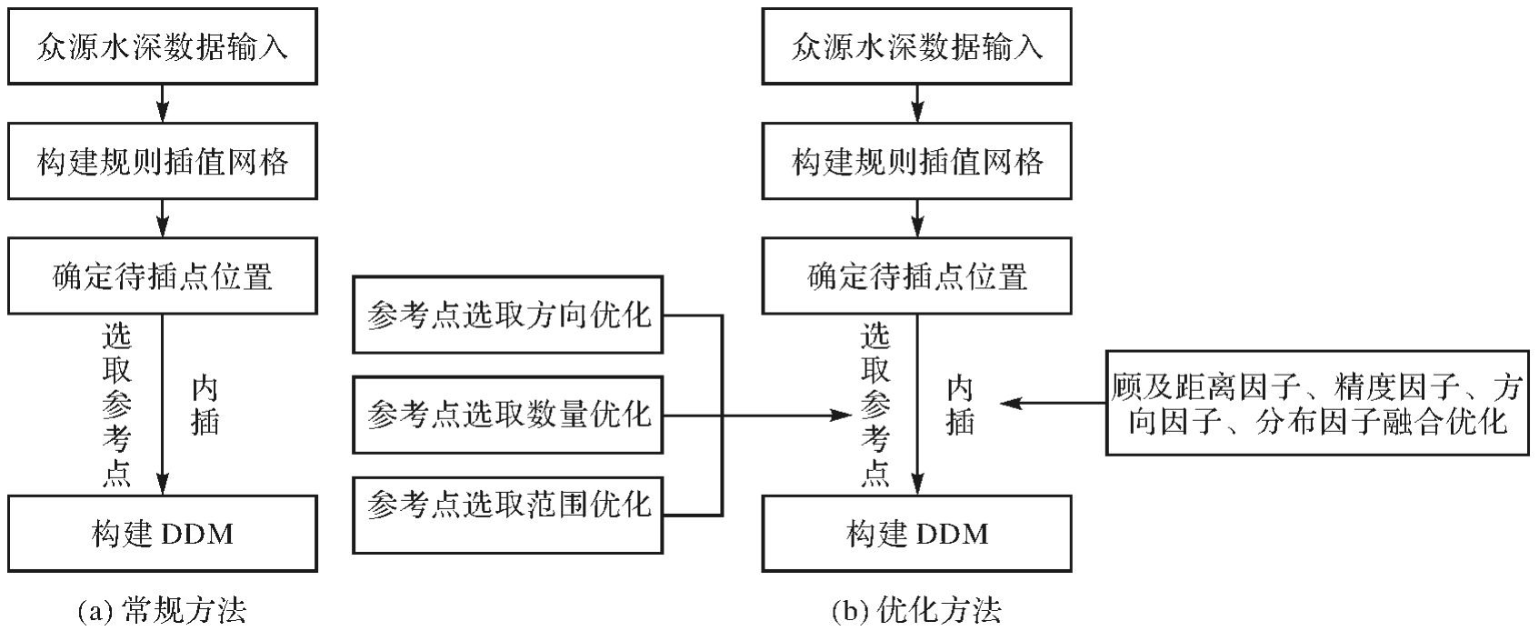
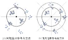
图2
参考点选取方法比较"
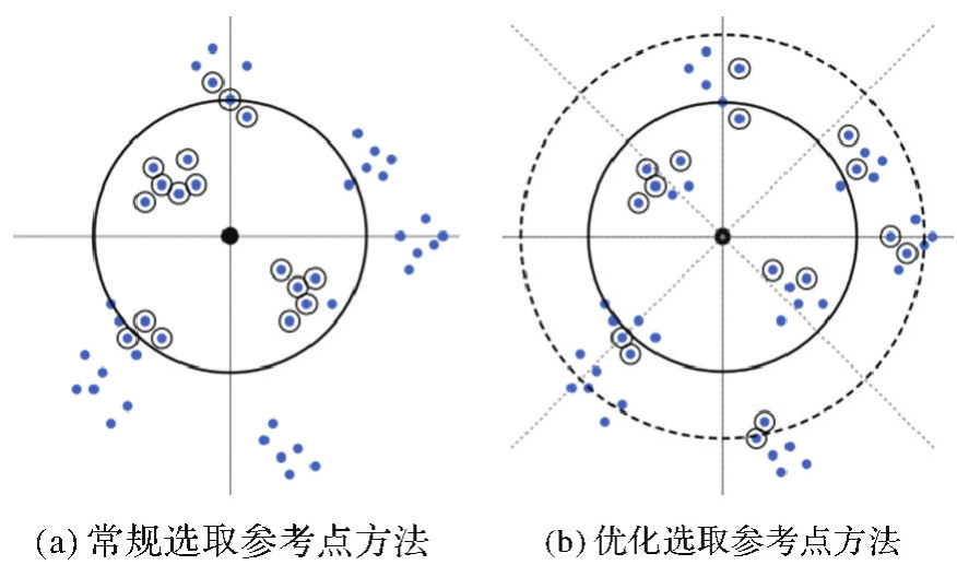
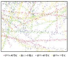
图3
众源水深数据分布"
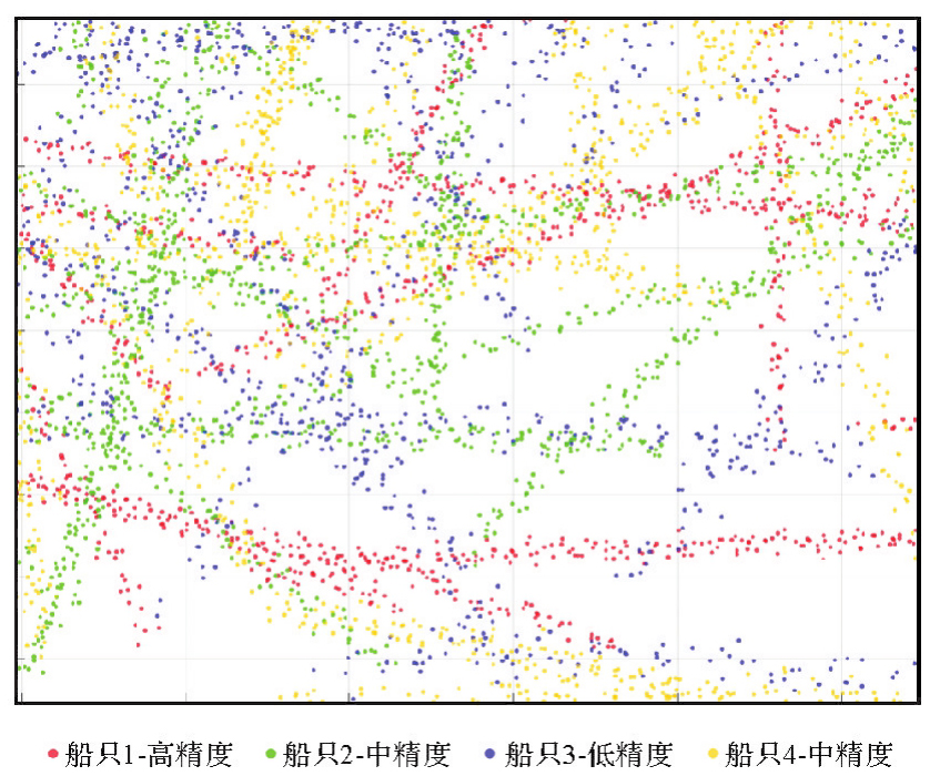
表1
测量数据来源"
| 编号 | 测量时间 | 定位手段 | 测深手段 | 作业条件 | 精度 |
|---|---|---|---|---|---|
| 1 | 2021 | GNSS | 单波束测深 | 海况好,航速平稳,设备状态良好 | 高 |
| 2 | 2021 | GNSS | 单波束测深 | 海况较好,船舶航行状态较稳定 | 中 |
| 3 | 2020 | GNSS | 单波束测深 | 海况较差,船舶航行状态颠簸 | 低 |
| 4 | 2018 | GNSS | 单波束测深 | 海况较好,船舶航行状态较稳定 | 中 |
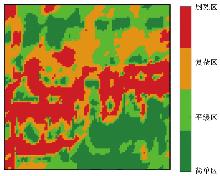
图4
试验海域分区"

表2
DDM整体精度比较"
| 方法 | RMSE | MAE |
|---|---|---|
| 常规IDW法 | 3.366 | 2.154 |
| 优化选取IDW法 | 3.338 | 2.110 |
| 优化内插IDW法 | 2.903 | 1.851 |
| 综合优化IDW法 | 2.829 | 1.794 |
| 克里金法 | 3.109 | 1.946 |
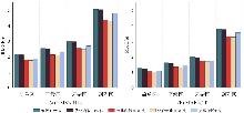
图5
不同区域DDM整体精度比较"
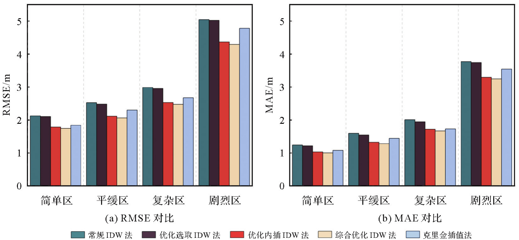
图6
点位分布"
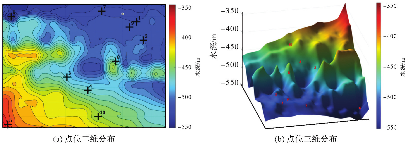
表3
5种方法在10个点位上绝对误差"
| 点号 | 参考值 | 克里金 | 常规IDW | 优化选取IDW | 优化内插IDW | 综合优化IDW | |||||
|---|---|---|---|---|---|---|---|---|---|---|---|
| 内插值 | 绝对误差 | 内插值 | 绝对误差 | 内插值 | 绝对误差 | 内插值 | 绝对误差 | 内插值 | 绝对误差 | ||
| 1 | 511.17 | 503.55 | 7.62 | 502.73 | 8.44 | 518.04 | 6.87 | 516.41 | 5.24 | 507.23 | 3.94 |
| 2 | 502.57 | 495.36 | 7.21 | 493.42 | 9.15 | 509.66 | 7.09 | 508.26 | 5.69 | 499.22 | 3.35 |
| 3 | 473.53 | 466.87 | 6.66 | 465.64 | 7.89 | 479.76 | 6.23 | 468.64 | 4.89 | 477.03 | 3.50 |
| 4 | 465.83 | 458.05 | 7.78 | 474.51 | 8.68 | 458.02 | 7.81 | 461.53 | 4.30 | 469.33 | 3.50 |
| 5 | 376.01 | 368.81 | 7.20 | 369.11 | 6.90 | 370.48 | 5.53 | 379.96 | 3.95 | 373.24 | 2.77 |
| 6 | 544.56 | 535.96 | 8.60 | 534.40 | 10.16 | 553.64 | 9.08 | 551.00 | 6.44 | 540.78 | 3.78 |
| 7 | 515.99 | 508.05 | 7.94 | 506.22 | 9.77 | 507.66 | 8.33 | 510.15 | 5.84 | 520.19 | 4.20 |
| 8 | 465.46 | 455.49 | 9.97 | 456.67 | 8.79 | 459.34 | 6.12 | 470.41 | 4.95 | 468.52 | 3.06 |
| 9 | 508.48 | 500.74 | 7.74 | 518.07 | 9.59 | 516.59 | 8.11 | 502.15 | 6.33 | 512.41 | 3.93 |
| 10 | 439.20 | 431.78 | 7.42 | 446.43 | 7.23 | 445.23 | 6.03 | 434.61 | 4.59 | 442.37 | 3.17 |
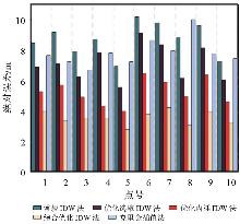
图7
5种方法绝对误差对比"
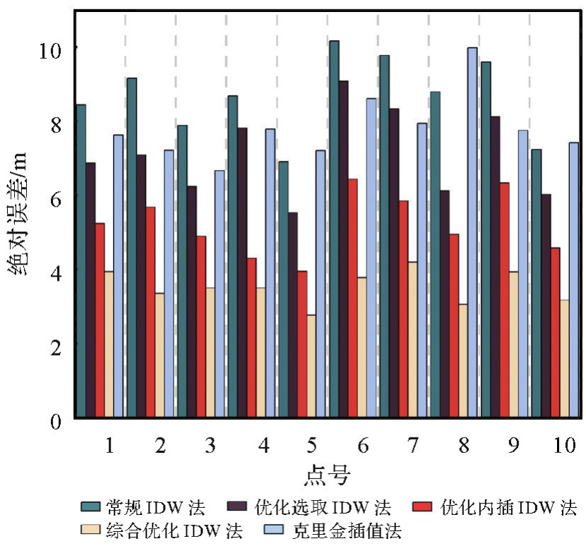
表4
不同权重组合的DDM整体精度比较"
| 权重因子组合 | RMSE | MAE |
|---|---|---|
| 单一距离因子 | 2.968 | 1.875 |
| 距离因子+分布因子 | 2.830 | 1.792 |
| 距离因子+分布因子+精度因子 | 2.903 | 1.851 |
| 距离因子+方位因子+分布因子 | 2.873 | 1.817 |
| 综合优化IDW法 | 2.829 | 1.794 |
| [1] | International Hydrographic Organization. IHO Hydrographic dictionary/multilingual reference for IHO publications: S-32[S]. Monaco: International Hydrographic Organization, 2019. |
| [2] | 《海洋测绘词典》编辑委员会. 海洋测绘词典[M]. 北京: 测绘出版社, 2022. |
| Editorial Board of Marine Surveying and Mapping Dictionary. Marine surveying and mapping dictionary[M]. Beijing: Surveying and Mapping Press, 2022. | |
| [3] | 阮晓光, 占赵杰, 闫兆进, 等. 基于全球测深数据的中国海岸线周边海域数字水深模型融合[J]. 海洋学报, 2024, 46(7): 16-28. |
| RUAN Xiaoguang, ZHAN Zhaojie, YAN Zhaojin, et al. Digital bathymetric model fusion of offshore waters around China's coastline based on global bathymetry data[J]. Haiyang Xuebao, 2024, 46(7): 16-28. | |
| [4] | HUANG Daozheng, WANG Shun, LOUGHNEY S, et al. Evolutionary game model of strategic maritime transport passages: a case of the strait of Hormuz[J]. Journal of Marine Science and Engineering, 2022, 10(3): 346. |
| [5] | 陶怡轩, 刘成彦, 王召民. 水文水深数据修正的普里兹湾数字水深模型[J]. 大气科学学报, 2021, 44(1): 128-139. |
| TAO Yixuan, LIU Chengyan, WANG Zhaomin. An improved digital bathymetric model for Prydz Bay by hydrography observations[J]. Transactions of Atmospheric Sciences, 2021, 44(1): 128-139. | |
| [6] | AMANTE C J, EAKINS B W. Accuracy of interpolated bathymetry in digital elevation models[J]. Journal of Coastal Research, 2016, 76: 123-133. |
| [7] | MALEIKA W. Inverse distance weighting method optimization in the process of digital terrain model creation based on data collected from a multibeam echosounder[J]. Applied Geomatics, 2020, 12(4): 397-407. |
| [8] | LIU Zhiqiang, XU Bo, CHENG Bo, et al. Retracted interpolation parameters in inverse distance-weighted interpolation algorithm on DEM interpolation error[J]. Journal of Sensors, 2021: 3535195. |
| [9] | 王可伟, 高利华, 江锋. 基于改进反距离加权算法的海底DEM建模方法[J]. 海洋测绘, 2021, 41(1): 61-64. |
| WANG Kewei, GAO Lihua, JIANG Feng. A method of seabed DEM modeling based on the improved inverse distance weighted interpolation algorithm[J]. Hydrographic Surveying and Charting, 2021, 41(1): 61-64. | |
| [10] | 张洁, 段平. 地形因子对反距离加权插值方法(IDW)最优距离指数的影响分析[J]. 地理科学, 2023, 43(7): 1281-1290. |
| ZHANG Jie, DUAN Ping. Influence of terrain factors on optimal order distance of inverse distance weighted (IDW)[J]. Scientia Geographica Sinica, 2023, 43(7): 1281-1290. | |
| [11] | 王怀计, 祝俊慧, 胡莹, 等. 顾及特征水深点距离重分配的反距离加权插值算法[J]. 海洋通报, 2022, 41(1): 9-18. |
| WANG Huaiji, ZHU Junhui, HU Ying, et al. Inverse distance weighted interpolation with the consideration of distance redistribution of characteristic depth points[J]. Marine Science Bulletin, 2022, 41(1): 9-18. | |
| [12] | SONG Shangfa, WANG Siyu, ZHOU Fangpeng. Digital terrain model based on fractal compensated distance inverse weight interpolation[C]//Proceedings of 2025 International Conference on Intelligent Computing and Signal Processing (ICSP). Xi'an: IEEE, 2025: 1040-1043. |
| [13] | ZHANG Tao, XU Xiaosu, XU Shengbao. Method of establishing an underwater digital elevation terrain based on Kriging interpolation[J]. Measurement, 2015, 63: 287-298. |
| [14] | 董箭, 季宏超, 刘国辉, 等. 临界滚动球半径优化的非航海TIN-DDM自动综合算法[J]. 武汉大学学报(信息科学版), 2025, 50(5): 996-1005. |
| DONG Jian, JI Hongchao, LIU Guohui, et al. Non-navigational TIN-DDM automatic generalization algorithm for optimizing critical rolling ball radius[J]. Geomatics and Information Science of Wuhan University, 2025, 50(5): 996-1005. | |
| [15] | 贾俊涛, 翟京生, 孟婵媛, 等. 基于海量多波束数据的海底地形模型的构建与可视化[J]. 测绘科学技术学报, 2008, 25(4): 255-259. |
| JIA Juntao, ZHAI Jingsheng, MENG Chanyuan, et al. Construction and visualization of submarine DEM based on large number of multibeam data[J]. Journal of Geomatics Science and Technology, 2008, 25(4): 255-259. | |
| [16] | 刘杰, 张旗, 王荻. 基于全球海域多波束测深数据构建DBM与Web服务[J]. 海洋测绘, 2024, 44(2): 14-17. |
| LIU Jie, ZHANG Qi, WANG Di. Building DBM and web services based on global multibeam bathymetry data[J]. Hydrographic Surveying and Charting, 2024, 44(2): 14-17. | |
| [17] | 樊妙, 孙毅, 邢喆, 等. 基于多源水深数据融合的海底高精度地形重建[J]. 海洋学报, 2017, 39(1): 130-137. |
| FAN Miao, SUN Yi, XING Zhe, et al. Bathymetry fusion techniques for high-resolution digital bathymetric modeling[J]. Haiyang Xuebao, 2017, 39(1): 130-137. | |
| [18] | AMOROSO P P, AGUILAR F J, PARENTE C, et al. Statistical assessment of some interpolation methods for building grid format digital bathymetric models[J]. Remote Sensing, 2023, 15(8): 2072. |
| [19] | MA Huadong, ZHOU Haiying, WEN Yubo, et al. Accuracy analysis of interpolation method for abrupt change of seabed water depth[C]//Proceedings of 2022 International Conference on Geology, Mapping and Remote Sensing (ICGMRS). Zhoushan: IEEE, 2022: 818-821. |
| [20] | ŁACKA M, ŁUBCZONEK J. Methodology for creating a digital bathymetric model using neural networks for combined hydroacoustic and photogrammetric data in shallow water areas[J]. Sensors, 2024, 24(1): 175. |
| [21] | 王振, 张锡亭, 王建华. 基于BP神经网络的高分辨率海底地形跨层生成模型[J]. 应用科技, 2024, 51(1): 143-150, 176. |
| WANG Zhen, ZHANG Xiting, WANG Jianhua. High-resolution submarine topography cross-layer generation model via BP neural network[J]. Applied Science and Technology, 2024, 51(1): 143-150, 176. | |
| [22] | ZHANG Liwen, WEN Jiabao, HUO Ziqiang, et al. From land to ocean: bathymetric terrain reconstruction via conditional generative adversarial network[J]. Earth Science Informatics, 2024, 17(5): 4361-4375. |
| [23] | SRIVASTAVA S P. Davis strait: structures, origin and evolution[M]//Structure and development of the Greenland-Scotland Ridge. Boston: Springer, 1983: 159-189. |
| [24] | AYDOGDU Y V. A comparison of maritime risk perception and accident statistics in the Istanbul straight[J]. Journal of Navigation, 2014, 67(1): 129-144. |
| [25] | PAYNE P. Crowdsourced bathymetry and its use to support resurvey activity in the North Sea region[J]. The International Hydrographic Review, 2023, 29(2): 248-253. |
| [26] | 邬金, 王平, 王久, 等. 众包水深测量的关键技术研究与分析[J]. 海洋测绘, 2020, 40(2): 36-40. |
| WU Jin, WANG Ping, WANG Jiu, et al. Research and analysis of key methods for crowdsourced bathymetry[J]. Hydrographic Surveying and Charting, 2020, 40(2): 36-40. | |
| [27] | International Hydrographic Organization. Guidance on crowdsourced bathysmetry(3.0.0)[R]. Monaco: IHO, 2024. |
| [28] | RADIĆ T, PAVIĆ I, MIŠKOVIĆ J. Comparison of hydrographic survey data with crowdsourced bathymetry data[J]. Naše More, 2023, 70(2): 115-125. |
| [29] | WANG Dejun, WANG Yanxia, LIANG Shan, et al. A N-order interpolated variance estimator algorithm for fusion of inland waterway crowd-sourced bathymetry data[C]//Proceedings of 2022 International Conference on Intelligent Transportation Engineering (ICITE). Beijing: IEEE, 2023: 66-71. |
| [30] | WAMAI M, TAN Qulin. Evaluating the impact of different point cloud sampling techniques on digital elevation model accuracy-a case study of Kituro, Kenya[J]. Earth Science Informatics, 2024, 17(6): 5149-5169. |
| [31] | ZHANG Hairong, LU Lijiang, LIU Yanhua, et al. Spatial sampling strategies for the effect of interpolation accuracy[J]. ISPRS International Journal of Geo-Information, 2015, 4(4): 2742-2768. |
| [32] | ZHANG Jinming. Optimization of interpolation parameters based on statistical experiment[J]. Open Geosciences, 2022, 14(1): 880-905. |
| [33] | 兰燕, 王明华, 刘珊红, 等. 逐点内插法建立DEM的研究[J]. 测绘科学, 2009, 34(1): 214-216. |
| LAN Yan, WANG Minghua, LIU Shanhong, et al. Study on building DEM based on point-by-point interpolation algorithm[J]. Science of Surveying and Mapping, 2009, 34(1): 214-216. | |
| [34] | LI Jin, HEAP A D. Spatial interpolation methods applied in the environmental sciences: a review[J]. Environmental Modelling & Software, 2014, 53: 173-189. |
| [35] | CRESSIE N A C. Statistics for spatial data[M]. New York: Wiley, 2015. |
| [36] | 汤国安, 刘学军, 闾国年. 数字高程模型及地学分析的原理与方法[M]. 北京: 科学出版社, 2005. |
| TANG Guoan, LIU Xuejun, LÜ Guonian. Principles and methods of digital elevation model and geoscience analysis[M]. Beijing: Science Press, 2005. | |
| [37] | 王家耀. 空间信息系统原理[M]. 北京: 科学出版社, 2001. |
| WANG Jiayao. Principle of spatial information system[M]. Beijing: Science Press, 2001. | |
| [38] | BATOOL A, AHMAD S, WASEEM A, et al. Evaluating variogram models and Kriging approaches for analyzing spatial trends in precipitation simulations from global climate models[J]. Acta Geophysica, 2025, 73(4): 3677-3697. |
| [39] | 张一凡, 张璐璐, 徐加宝. 地质统计学变异函数贝叶斯模型选择方法与比较[J]. 地质科技通报, 2025, 44(2): 38-47. |
| ZHANG Yifan, ZHANG Lulu, XU Jiabao. Bayesian methods for geostatistical variogram model selection and comparative study[J]. Bulletin of Geological Science and Technology, 2025, 44(2): 38-47. | |
| [40] | 徐武平, 邱峰, 徐爱萍. 空间数据插值的自动化方法研究[J]. 武汉大学学报(信息科学版), 2016, 41(4): 498-502. |
| XU Wuping, QIU Feng, XU Aiping. Automatic method of Kriging interpolation of spatial data[J]. Geomatics and Information Science of Wuhan University, 2016, 41(4): 498-502. | |
| [41] | LIU Longdong, WANG Baoli, LIN Ying, et al. Anisotropic spatial structure Kriging interpolation method based on statistical characteristic parameters of random media[J]. IEEE Transactions on Geoscience and Remote Sensing, 2025, 63: 4506017. |
| [42] | PAVIC I, MIŁKOVIC J, KASUM J, et al. Analysis of crowdsourced bathymetry concept and it's potential implications on safety of navigation[J]. TransNav, the International Journal on Marine Navigation and Safety of Sea Transportation, 2020, 14(3): 681-686. |
| [1] | 严清赟, 郭紫璇, 潘元进, 贾燕, 金双根. GNSS-R陆表反射率空间分异驱动因子定量分析与分区模式[J]. 测绘学报, 2026, 55(2): 315-327. |
| [2] | 邓敏, 彭翀, 谌恺祺. 顾及地理空间特性的空间面板数据可预测性评估理论与方法[J]. 测绘学报, 2025, 54(7): 1305-1317. |
| [3] | 刘雅婷, 陈传法. 顾及空间异质性和特征优选的滑坡易发性评价方法[J]. 测绘学报, 2024, 53(7): 1417-1428. |
| [4] | 皮新宇, 曾永年, 王盼成. 面向非均质区域的空间增强型时空融合模型研究[J]. 测绘学报, 2023, 52(10): 1714-1723. |
| [5] | 彭认灿, 董箭, 贾帅东, 唐露露, 王芳. 数字水深模型建模技术研究进展与展望[J]. 测绘学报, 2022, 51(7): 1575-1587. |
| [6] | 刘洋, 吴自银, 赵荻能, 周洁琼, 尚继宏, 王明伟, 朱超, 鲁号号. MF多源测深数据融合方法及大洋水深模型构建[J]. 测绘学报, 2019, 48(9): 1171-1181. |
| [7] | 董箭, 彭认灿, 张立华, 刘国辉, 朱强. 顾及“保真性”原则的双向滚动球变换DDM多尺度表达算法[J]. 测绘学报, 2017, 46(6): 789-801. |
| [8] | 蔡建南, 刘启亮, 徐枫, 邓敏, 何占军, 唐建波. 多层次空间同位模式自适应挖掘方法[J]. 测绘学报, 2016, 45(4): 475-485. |
| [9] | 贾帅东,张立华,宋国大,丁金挺. 基于区域平均垂直不确定度的自适应格网水深建模方法[J]. 测绘学报, 2012, 41(3): 0-416. |
| [10] | 张立华,贾帅东,吴超,殷晓冬. 顾及不确定度的数字水深模型内插方法[J]. 测绘学报, 2011, 40(3): 359-365. |
| 阅读次数 | ||||||
|
全文 |
|
|||||
|
摘要 |
|
|||||