

Acta Geodaetica et Cartographica Sinica ›› 2025, Vol. 54 ›› Issue (4): 714-724.doi: 10.11947/j.AGCS.2025.20240340
• Geodesy and Navigation • Previous Articles Next Articles
Zhenhe ZHAI1( ), Zhongmiao SUN1, Jian MA1, Bin GUAN1, He HUANG1, Mingda OUYANG1, Lingyong HUANG2, Zhiyong HUANG2, Xingchen PAN2, Shigeng YUAN3, Shengli LIU4, Sen LIU4
Received:2024-08-20
Online:2025-05-30
Published:2025-05-30
About author:ZHAI Zhenhe (1980—), male, PhD, associate researcher, majors in marine surveying and gravity magnetic exploration. E-mail: zhaizhenhe1980@163.com
Supported by:CLC Number:
Zhenhe ZHAI, Zhongmiao SUN, Jian MA, Bin GUAN, He HUANG, Mingda OUYANG, Lingyong HUANG, Zhiyong HUANG, Xingchen PAN, Shigeng YUAN, Shengli LIU, Sen LIU. Gravity field inversion from China ocean altimetry tandem satellites data and performance analysis[J]. Acta Geodaetica et Cartographica Sinica, 2025, 54(4): 714-724.
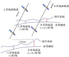
Fig. 1
Double satellite tandem following"
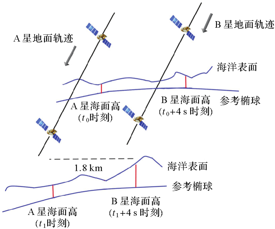
Fig. 2
The ground track distribution of 2.5 years in tandem model"
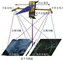
Fig. 3
SWOT interferometric altimetry"

Tab. 1
Correction method of COATS AB sea surface height error"
| 误差改正项 | 改正模型 |
|---|---|
| 电离层误差 | Ku/C双频改正 |
| 干对流层误差 | Saastamoinen(1972)模型 |
| 湿对流层误差 | 三频校正辐射计 |
| 海洋潮汐 | FES2014b模型 |
| 固体潮汐 | Cartwright and Taylor 1973模型 |
| 极潮 | IERS Equilibrium模型,Wahr(1985)模型 |
| 逆气压改正 | Wunsch and Stammer(1997)模型 |
| 海况偏差改正 | NPSSB模型 |
Fig. 4
COATS A original sea surface height data"

Fig. 5
COATS B original sea surface height data"
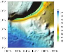
Fig. 6
COATS A sea surface height data (processed)"
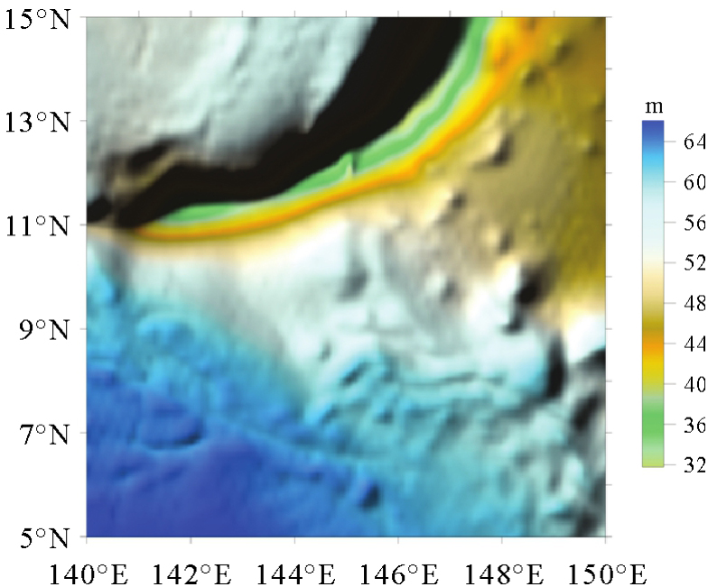
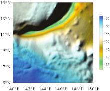
Fig. 7
COATS B sea surface height data (processed)"
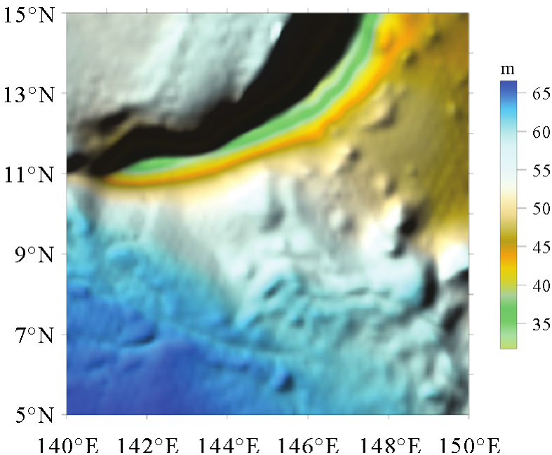
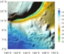
Fig. 8
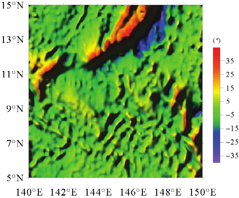
Sea surface height data after COATS A and B combination"
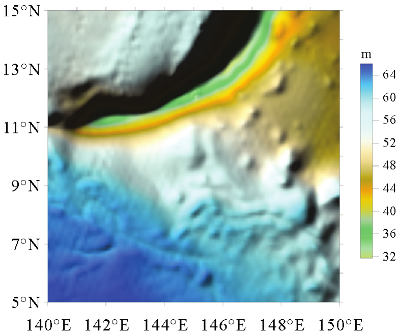
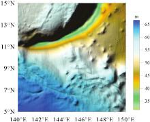
Fig. 9
SWOT sea surface height data"


Fig. 10
DTU15 mean dynamic topography of research area"
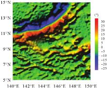
Fig. 11
Meridian component of vertical deflection from COATS data"
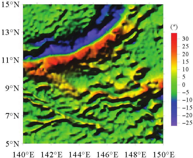
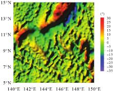
Fig. 12
East-west component of vertical deflection from COATS data"

Tab. 2
The vertical deflection statistics obtained by COATS compared with EIGEN-6C4"
| 比较类型 | 格网大小 | 最大值/(″) | 最小值/(″) | 差值均值/(″) | 标准差/(″) | 参与评估的数量 |
|---|---|---|---|---|---|---|
| 南北 | 1′×1′ | 11.36 | -10.28 | 0.11 | 1.65 | 82 534 |
| 分量 | 5′×5′ | 11.13 | -9.36 | 0.10 | 1.51 | 14 400 |
| 东西 | 1′×1′ | 28.42 | -16.70 | 0.28 | 2.37 | 82 534 |
| 分量 | 5′×5′ | 24.86 | -16.34 | 0.23 | 2.28 | 14 400 |
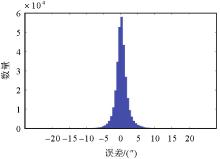
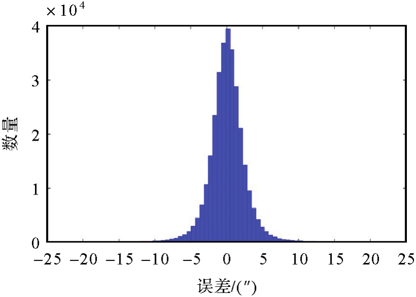
Fig. 13
Error distribution of meridian component of vertical deflection (1′×1′)"


Fig. 14
Error distribution of east-west component of vertical deflection (1′×1′)"
Tab. 3
Gravity anomalies calculated from COATS data compared with SIO 32.1"
| 比较类型 | 格网大小 | 最大值/mGal | 最小值/m Gal | 差值均值/m Gal | 标准差/mGal | 参与评估的数量 |
|---|---|---|---|---|---|---|
| 格网 | 5′×5′ | 48.71 | -47.24 | 0.06 | 6.42 | 14 400 |
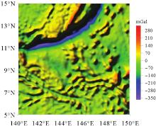
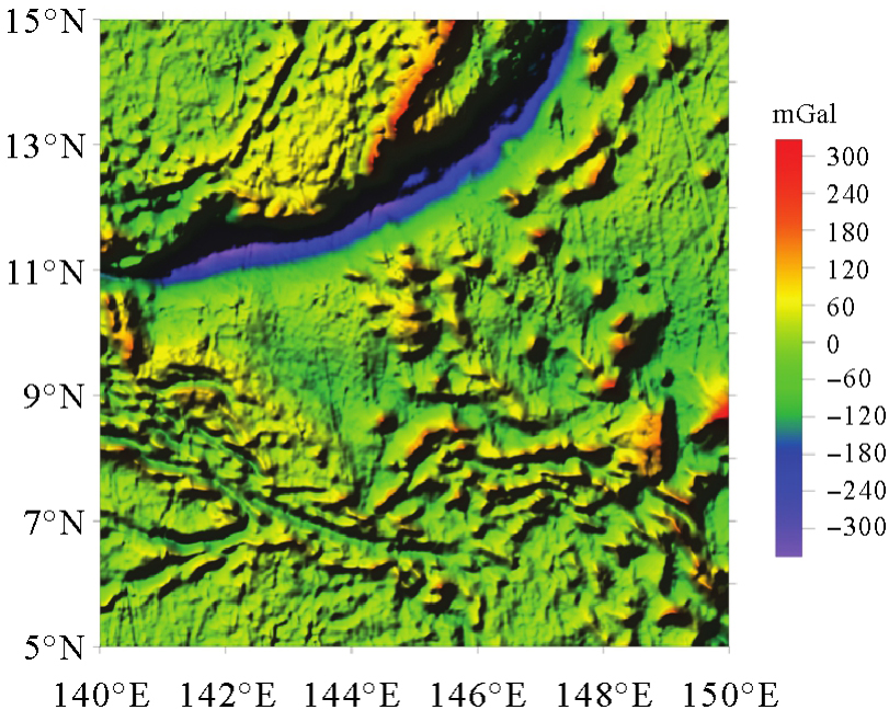
Fig. 15
Gravity anomalies calculated from COATS data (5′×5′)"

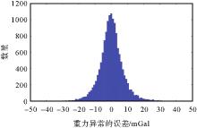
Fig. 16
Error distribution of gravity anomaly by using COATS data (5′×5′)"
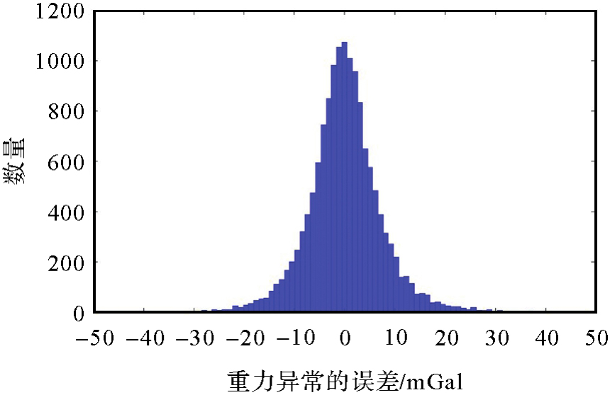
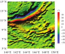
Fig. 17
Vertical deflection meridian component of SWOT"

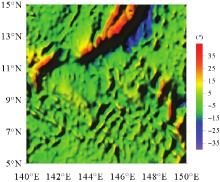
Fig. 18
Vertical deflection east-west component of SWOT"
Tab. 4
Results of vertical deflection model of SWOT versus EIGEN-6C4"
| 比较类型 | 格网大小 | 最大值/(″) | 最小值/(″) | 差值均值/(″) | 标准差/(″) | 参与评估的数量 |
|---|---|---|---|---|---|---|
| 南北 | 1′×1′ | 37.75 | -21.89 | 0.08 | 1.73 | 359 062 |
| 分量 | 5′×5′ | 15.64 | -24.39 | 0.07 | 1.69 | 14 400 |
| 东西 | 1′×1′ | 38.62 | -40.31 | 0.04 | 1.87 | 359 062 |
| 分量 | 5′×5′ | 21.64 | -20.31 | 0.03 | 1.52 | 14 400 |

Fig. 19
Error distribution of meridian component of vertical deflection (1′×1′)"

Fig. 20
Error distribution of east-west component of vertical deflection"
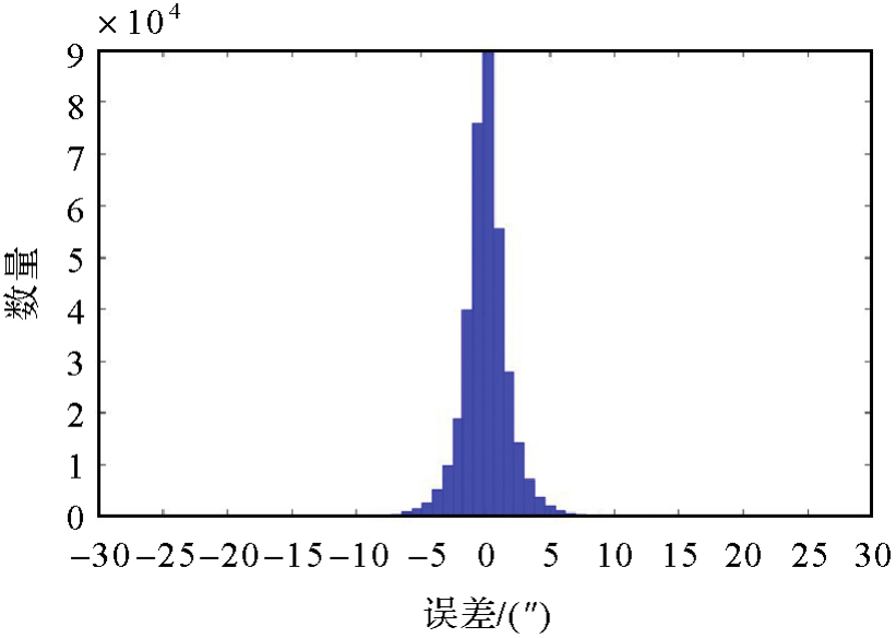
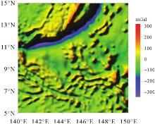
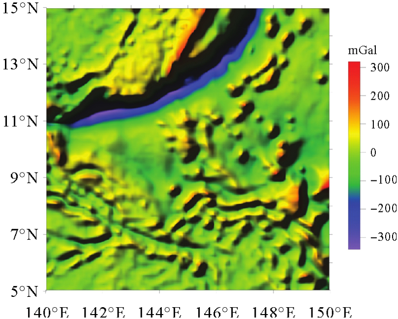
Fig. 21
Gravity anomaly derived from SWOT"
Tab. 5
Results statistics for gravity anomaly calculated from SWOT data versus SIO 32.1"
| 比较类型 | 格网大小 | 最大值/mGal | 最小值/m Gal | 差值均值/m Gal | 标准差/mGal | 参与评估的数量 |
|---|---|---|---|---|---|---|
| 格网 | 5′×5′ | 92.14 | -60.30 | -0.05 | 5.25 | 14 400 |
Tab. 6
Results of vertical deflection derived from COATS and SWOT versus EIGEN-6C4"
| 比较类型 | 赋权原则 | 格网大小 | 最大值/(″) | 最小值/(″) | 差值均值/(″) | 标准差/(″) | 参与评估的数量 |
|---|---|---|---|---|---|---|---|
| 南北 | 等权 | 1′×1′ | 47.19 | -70.08 | 0.14 | 1.84 | 360 000 |
| 分量 | 不等权 | 47.18 | -69.58 | 0.15 | 1.72 | ||
| 东西 | 等权 | 1′×1′ | 59.41 | -67.62 | 0.09 | 1.81 | 360 000 |
| 分量 | 不等权 | 58.72 | -63.65 | 0.09 | 1.81 |
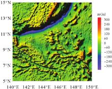
Fig. 22
Gravity anomaly derived from SWOT and COATS (1′×1′)"
Tab. 7
Results statistics for gravity anomaly calculated from SWOT&COATS data versus SIO 32.1"
| 比较数据 | 格网大小 | 最大值/mGal | 最小值/mGal | 差值均值/mGal | 标准差/mGal | 参与评估的数量 |
|---|---|---|---|---|---|---|
| COATS&SWOT | 5′×5′ | 91.18 | -59.85 | 0.02 | 5.07 | 14 400 |
| 1′×1′ | 59.84 | -59.97 | 0.01 | 4.96 | 360 000 | |
| EIGEN-6C4 | 1′×1′ | 59.78 | -49.05 | -0.06 | 8.09 | 360 000 |
| [1] | 许厚泽, 王海瑛, 陆洋, 等. 利用卫星测高数据推求中国近海及邻域大地水准面起伏和重力异常研究[J]. 地球物理学报, 1999. 42(4): 465-471. |
| XU Houze, WANG Haiying, LU Yang, et al. Geoid undulations and gravity anomalies from T/P and ERS-1altimeter data in the China sea and vicinity[J]. Chinese Journal of Geophysics(in Chinese), 1999, 42(4): 465-471. | |
| [2] | 李建成, 陈俊勇, 宁津生, 等. 地球重力场逼近理论与中国2000似大地水准面的确定[M]. 武汉: 武汉大学出版社, 2003. |
| LI Jiancheng, CHEN Junyong, NING Jinshen, et al. Approximation theory of earth gravity field and determination of China 2000 quasi geoid(in Chinese)[M]. Wuhan: Wuhan University Press, 2003. | |
| [3] | VIGNUDELL I, KOSTIANOY A, CIPOLLINI P. Coastal altimetry[M]. Berlin: Springer, 2011. |
| [4] | SANDWELL D T, MÜLLER R D, SMITH W H F, et al. New global marine gravity model from CryoSat-2 and Jason-1 reveals buried tectonic structure[J]. Science, 2014, 346(6205): 65-67. |
| [5] |
胡敏章, 张胜军, 金涛勇, 等. 新一代全球海底地形模型BATWHU2020[J]. 测绘学报, 2020, 49(8): 939-954. DOI:.
doi: 10.11947/j.AGCS.2020.20190526 |
|
HU Minzhang, ZHANG Shengjun, JIN Taoyong, et al. A new generation of global bathymetry model BATWHU2020[J]. Acta Geodaetica et Cartographica Sinica, 2020, 49(8): 939-954. DOI:.
doi: 10.11947/j.AGCS.2020.20190526 |
|
| [6] | 黄谟涛, 欧阳永忠, 边少锋, 等. 美俄水下重力辅助惯性导航技术发展分析与思考[J]. 武汉大学学报(信息科学版), 2024, 49(11): 1977-1991. |
| HUANG Motao, OUYANG Yongzhong, BIAN Shaofeng, et al. Analysis and reflections on the development of underwater gravity-aided inertial navigation technology in the United States and Russia[J]. Geomatics and Information Science of Wuhan University, 2024, 49(11): 1977-1991. | |
| [7] | 文汉江, 金涛勇, 朱广彬. 卫星测高原理及应用[M]. 北京: 测绘出版社, 2017. |
| WEN Hanjiang, JIN Taoyong, ZHU Guangbin. Principle and application of satellite altimetry[M]. Beijing: Surveying and Mapping Press, 2017. | |
| [8] | RANEY R K, PORTER D L. WITTEX: an innovative three-satellite radar altimeter concept[C]//Proceedings of 2001 IEEE Transactions on Geoscience and Remote Sensing. [S.l.]: IEEE, 2001: 2387-2391. |
| [9] |
鲍李峰, 许厚泽. 双星伴飞卫星测高模式及其轨道设计[J]. 测绘学报, 2014, 43(7): 661-667. DOI:.
doi: 10.13485/j.cnki.11-2089.2014.0109 |
|
BAO Lifeng, XU Houze. Twin-satellites altimetry mode and its orbit design[J]. Acta Geodaetica et Cartographica Sinica, 2014, 43(7): 661-667. DOI:.
doi: 10.13485/j.cnki.11-2089.2014.0109 |
|
| [10] |
孙中苗, 管斌, 翟振和, 等. 海洋卫星测高及其反演全球海洋重力场和海底地形模型研究进展[J]. 测绘学报, 2022, 51(6): 923-934. DOI:.
doi: 10.11947/j.AGCS.2022.20220069 |
|
SUN Zhongmiao, GUAN Bin, ZHAI Zhenhe, et al. Research progress of ocean satellite altimetry and its recovery of global marine gravity field and seafloor topography model[J]. Acta Geodaetica et Cartographica Sinica, 2022, 51(6): 923-934. DOI:.
doi: 10.11947/j.AGCS.2022.20220069 |
|
| [11] | 翟振和, 孙中苗, 肖云, 等. 自主海洋测高卫星串飞模式的设计与重力场反演精度分析[J]. 武汉大学学报(信息科学版), 2018, 43(7): 1030-1035, 1128. |
| ZHAI Zhenhe, SUN Zhongmiao, XIAO Yun, et al. Two-satellites tandem mode design and accuracy analysis of gravity field inversion for independent marine altimetry satellite[J]. Geomatics and Information Science of Wuhan University, 2018, 43(7): 1030-1035, 1128. | |
| [12] | 张胜军, 李建成, 褚永海, 等. 基于Cryosat和Jason1 GM数据的垂线偏差计算与分析[J]. 武汉大学学报(信息科学版), 2015, 40(8): 1012-1017. |
| ZHANG Shengjun, LI Jiancheng, CHU Yonghai, et al. Calculation and analysis of the deflection of vertical derived from cryosat and Jason1 GM data[J]. Geomatics and Information Science of Wuhan University, 2015, 40(8): 1012-1017. | |
| [13] | MA Zhimin, HAN Guoqi. Reconstruction of the surface inshore labrador current from SWOT sea surface height measurements[J]. Remote Sensing, 2019, 11(11): 1264. |
| [14] | PIE N, SCHUTZ B E. Subcycle analysis for ICESat's repeat groundtrack orbits and application to phasing maneuvers[J]. The Journal of the Astronautical Sciences, 2008, 56(3): 325-340. |
| [15] | GUO Jinyun, GAO Yonggang, HWANG C, et al. A multi-subwaveform parametric retracker of the radar satellite altimetric waveform and recovery of gravity anomalies over coastal oceans[J]. Science China Earth Sciences, 2010, 53(4): 610-616. |
| [16] | ZHANG Shengjun, SANDWELL D T, JIN Taoyong, et al. Inversion of marine gravity anomalies over southeastern China seas from multi-satellite altimeter vertical deflections[J]. Journal of Applied Geophysics, 2017, 137: 128-137. |
| [17] | FAIRHEAD J D. Generating a high-resolution global gravity model for oil exploration: part 2: marine satellite altimeter-derived gravity[J]. The Leading Edge, 2015, 34(5): 566-571. |
| [18] | SANDWELL D T, SMITH W H F. Marine gravity anomaly from Geosat and ERS 1 satellite altimetry[J]. Journal of Geophysical Research: Solid Earth, 1997, 102(B5): 10039-10054. |
| [19] | HWANG C, PARSONS B. Gravity anomalies derived from Sea-sat, Geosat, ERS-1 and TOPEX/POSEIDON altimetry and ship gravity: a case-study over the Reykjanes Ridge[J]. Geophysical Journal of International Society. 1995, 122, 511-568. |
| [20] | VERRON J, SENGENES P, LAMBIN J, et al. The SARAL/AltiKa altimetry satellite mission[J]. Marine Geodesy, 2015, 38(): 2-21. |
| [21] | ZHANG Shengjun, SANDWELL D T. Retracking of SARAL/AltiKa radar altimetry waveforms for optimal gravity field recovery[J]. Marine Geodesy, 2017, 40(1): 40-56. |
| [22] | ZHAO Yili, ZHU Jianhua, LIN Mingsen, et al. Assessment of the initial sea surface temperature product of the scanning microwave radiometer aboard on HY-2 satellite[J]. Acta Oceanologica Sinica, 2014, 33(1): 109-113. |
| [23] | 贾永君, 林明森, 张有广. 海洋二号卫星A星雷达高度计在海洋防灾减灾中的应用[J]. 卫星应用, 2018(5): 34-35, 38-39. |
| JIA Yongjun, LIN Mingsen, ZHANG Youguang. Application of Ocean-2 satellite A radar altimeter in marine disaster prevention and mitigation[J]. Satellite Application, 2018(5): 34-35, 38-39. | |
| [24] | HWANG C. Inverse vening meinesz formula and deflection-geoid formula: applications to the predictions of gravity and geoid over the South China Sea[J]. Journal of Geodesy, 1998, 72(5): 304-312. |
| [25] | SANDWELL D T, GARCIA E, SOOFI K, et al. Towards 1 mGal global marine gravity from CryoSat-2, Envisat, and Jason-1[J]. The Leading Edge, 32(8), 892899. |
| [26] | ABULAITIJIANG A, ANDERSEN O B, BARZAGHI R, et al. Coastal marine gravity modelling from satellite altimetry-case study in the Mediterranean[J]. Journal of Geodetic Science, 2021, 11(1): 29-37. |
| [27] | HARTANTO P, HUDA S, PUTRA W, et al. Estimation of marine gravity anomaly model from satellite altimetry data (Case Study: Kalimantan and Sulawesi Waters-Indonesia)[J]. IOP Conference Series: Earth and Environmental Science, 2018, 162: 012038. |
| [28] | ZHU Fengshun, GUO Jinyun, ZHANG Huiying, et al. SDUST2020MGCR: a global marine gravity change rate model determined from multi-satellite altimeter data[J]. Earth System Science Data, 2024, 16(5): 2281-2296. |
| [29] | HWANG C, KAO E C, PARSONS B. Global derivation of marine gravity anomalies from Seasat, Geosat, ERS-1 and TOPEX/POSEIDON altimeter data[J]. Geophysical Journal International, 1998, 134(2): 449-459. |
| [30] | OLGIATI A, BALMINO G, SARRAILH M, et al. Gravity anomalies from satellite altimetry: comparison between computation via geoid heights and via deflections of the vertical[J]. Bulletin Géodésique, 1995, 69(4): 252-260. |
| [31] |
翟振和, 孙中苗, 王兴涛. 全球及局部海洋扰动重力反演的快速解析方法[J]. 测绘学报, 2015, 44(8): 827-830. DOI:.
doi: 10.11947/j.AGCS.2015.20140482 |
|
ZHAI Zhenhe, SUN Zhongmiao, WANG Xingtao. The analytical and quick computation method of disturbing gravity in global and local ocean area[J]. Acta Geodaetica et Cartographica Sinica, 2015, 44(8): 827-832. DOI:.
doi: 10.11947/j.AGCS.2015.20140482 |
|
| [32] | WESSEL P, LYONS S. Distribution of large Pacific seamounts from geosat/ERS-1: implications for the history of intraplate volcanism[J]. Journal of Geophysical Research: Solid Earth, 1997, 102(B10): 22459-22475. |
| [33] | SHAKO R, FÖRSTE C, ABRYKOSOV O, et al. EIGEN-6C: a high-resolution global gravity combination model including GOCE data[M]. Berlin: Springer, 2014. |
| [1] | Yunpeng WANG, Xiaogang LIU, Qi LI, Duan LI, Liu FANG. Construction of series ultra-high-degree Earth's gravity field models DQM2022 and their precision evaluation [J]. Acta Geodaetica et Cartographica Sinica, 2024, 53(8): 1505-1516. |
| [2] | Xiaoran HAN, Yinghai KE, Jinyuan YU, Mengjie ZHAO, Guoqing ZHANG. Accuracy assessment of lake level and area measurement in the Qinghai-Tibet Plateau using simulated SWOT satellite data [J]. Acta Geodaetica et Cartographica Sinica, 2024, 53(5): 823-834. |
| [3] | ZHAN Yinhu, ZHANG Chao, LI Feizhan, LUO Yabo, MI Kefeng, ZHANG Xu, ZHANG Zhifeng. Astro-geodetic vertical deflection measurement and accuracy analysis based on image total station [J]. Acta Geodaetica et Cartographica Sinica, 2023, 52(2): 175-182. |
| [4] | ZHANG Shengjun, LI Jiancheng, KONG Xiangxue. Inversion of global marine gravity anomalies with vertical deflection method deduced from Laplace equation [J]. Acta Geodaetica et Cartographica Sinica, 2020, 49(4): 452-460. |
| [5] | XING Zhibin, LI Shanshan. The 3D Gravity Vectors Method in China Land and Ocean Quasi-geoid Determination [J]. Acta Geodaetica et Cartographica Sinica, 2018, 47(5): 575-583. |
| [6] | WANG Hubiao, WANG Yong, CAI Hua, BAO Lifeng. 1'×1' Vertical Deflection and Its Precision Evaluation on China West Pacific Ocean Region [J]. Acta Geodaetica et Cartographica Sinica, 2017, 46(9): 1073-1079. |
| [7] | WAN Xiaoyun, ZHANG Running, LI Yang, LIU Bo, SUI Xiaohong. Matching Relationship between Precisions of Gravity Anomaly and Vertical Deflections in terms of Spherical Harmonic Function [J]. Acta Geodaetica et Cartographica Sinica, 2017, 46(6): 706-713. |
| [8] | ZHAI Zhenhe, SUN Zhongmiao, WANG Xingtao. The Analytical and Quick Computation Method of Disturbing Gravity in Global and Local Ocean Area [J]. Acta Geodaetica et Cartographica Sinica, 2015, 44(8): 827-832. |
| Viewed | ||||||
|
Full text |
|
|||||
|
Abstract |
|
|||||