

Acta Geodaetica et Cartographica Sinica ›› 2025, Vol. 54 ›› Issue (4): 587-602.doi: 10.11947/j.AGCS.2025.20250051
• Review • Next Articles
Jianya GONG1( ), Peng YUE1,2,3,4(), Longgang XIANG5, Haoru WU1, Kaixuan WANG1, Ruixiang LIU1, Baoxin TENG1
Received:2025-02-09
Online:2025-05-30
Published:2025-05-30
Contact:
Peng YUE
E-mail:gongjy@whu.edu.cn;pyue@whu.edu.cn
About author:GONG Jianya (1957—), male, PhD, professor, academician of Chinese Academy of Sciences, majors in geographic information science and photogrammetry. E-mail: gongjy@whu.edu.cn
Supported by:CLC Number:
Jianya GONG, Peng YUE, Longgang XIANG, Haoru WU, Kaixuan WANG, Ruixiang LIU, Baoxin TENG. The design and implementation of the open geospatial engine (OGE)[J]. Acta Geodaetica et Cartographica Sinica, 2025, 54(4): 587-602.

Fig. 1
From spatiotemporal data services to spatio-temporal intelligent computing services"
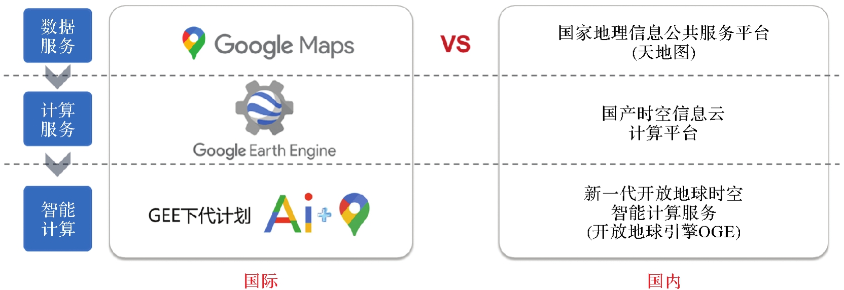
Fig. 2
Overview of OGE architecture"
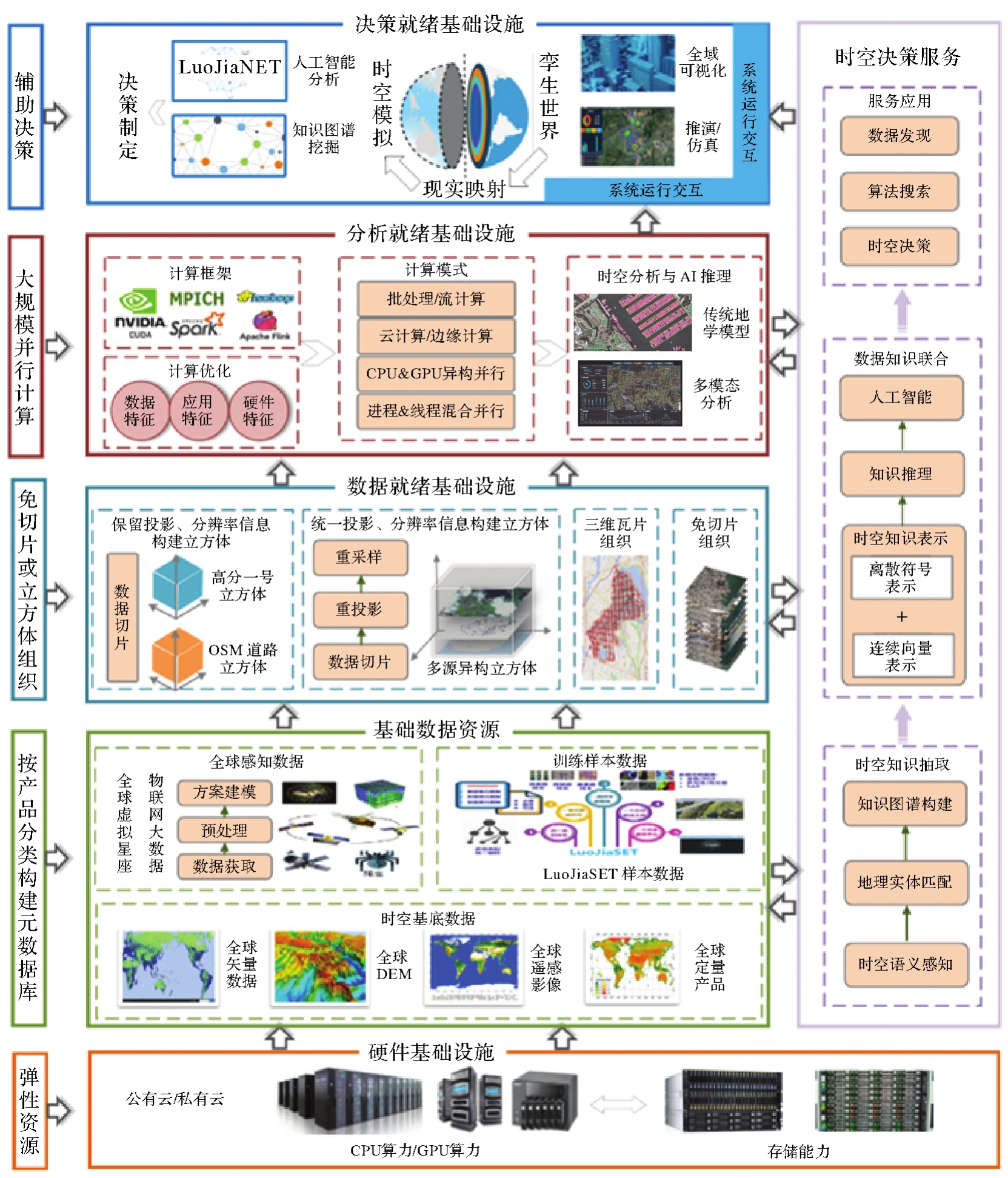
Fig. 3
GeoCube spatio-temporal data organization"
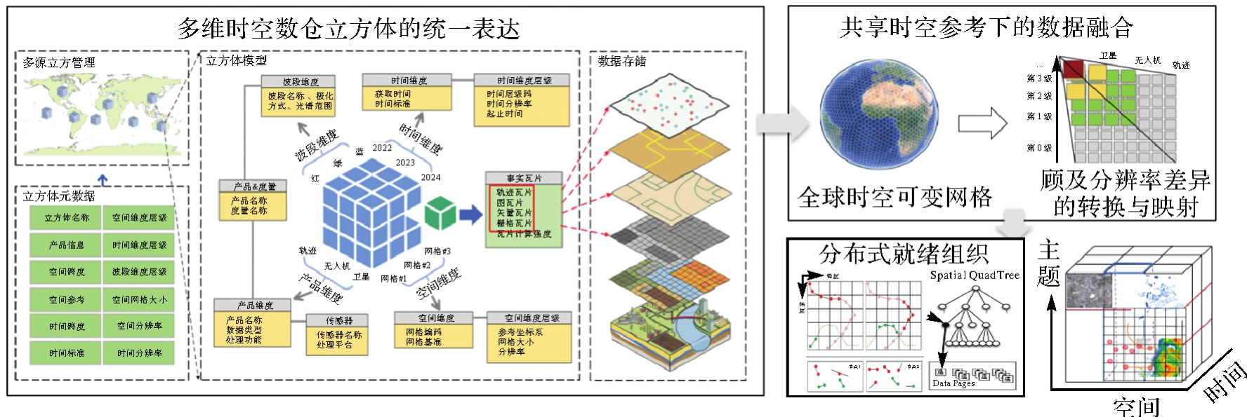
Fig. 4
Implementation of cloud native RDD object[30]"
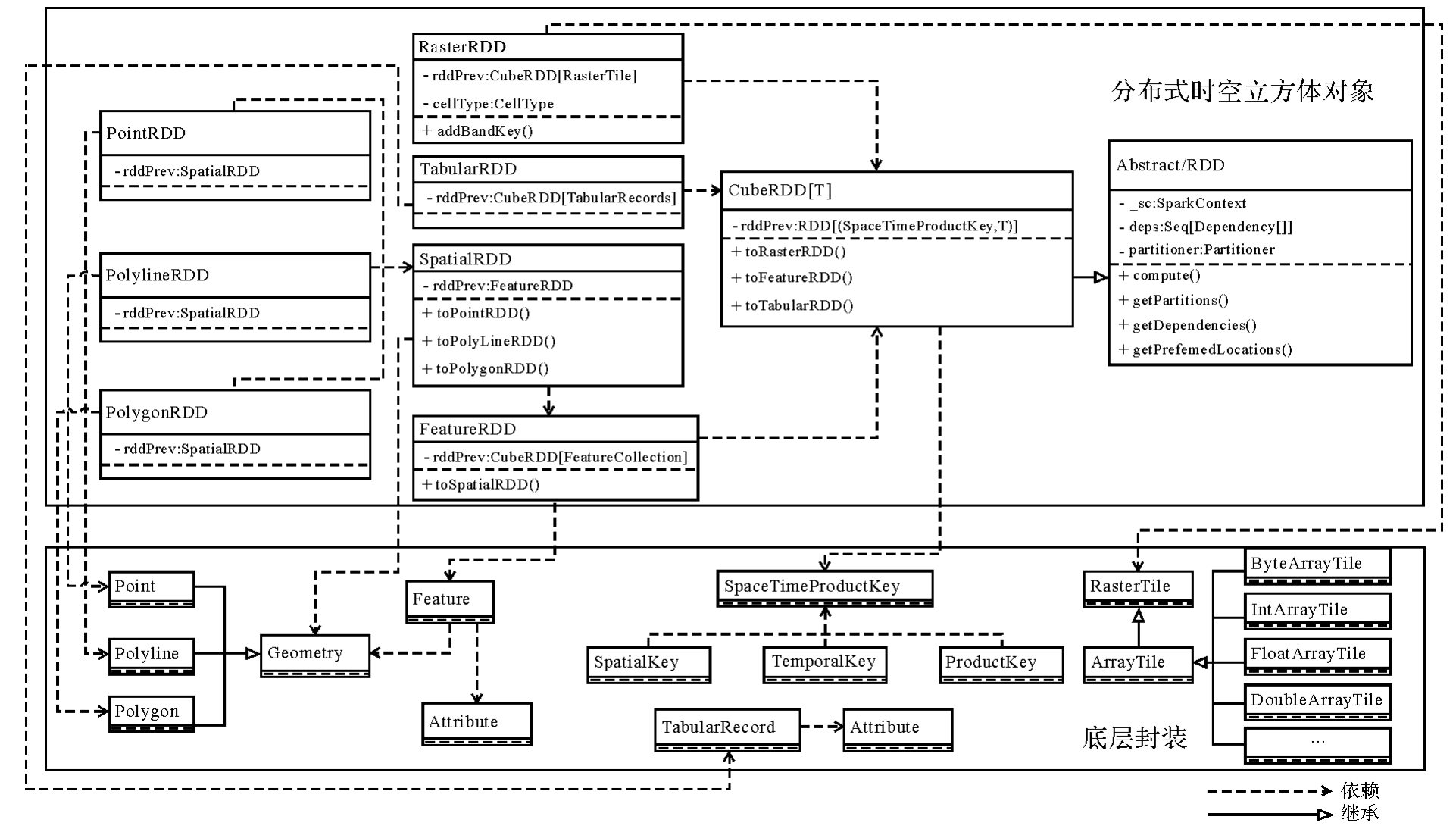
Fig. 5
OGE process and thread hybrid parallel mode"
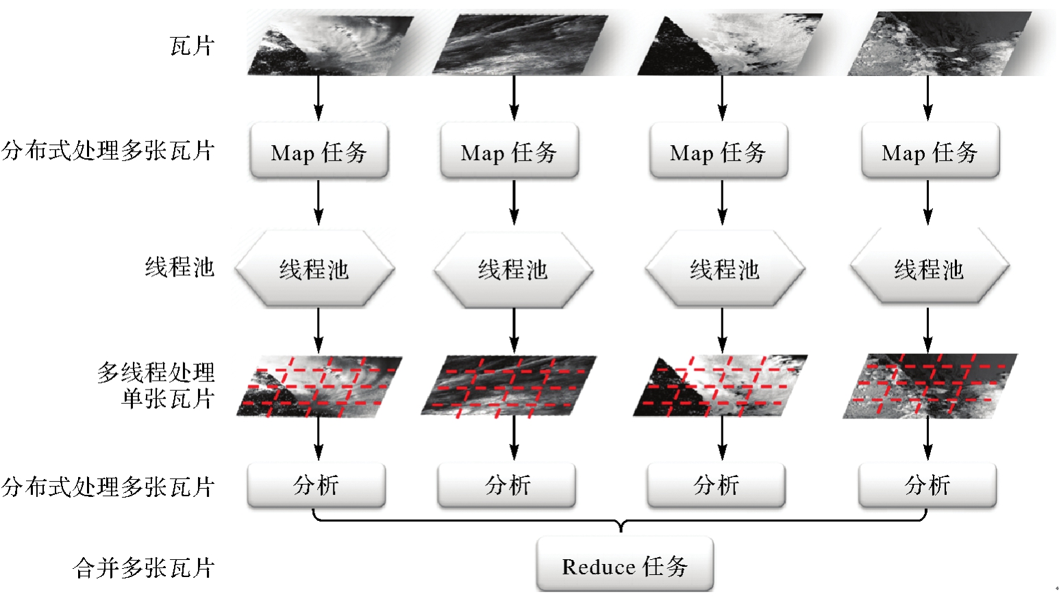
Fig. 6
OGE learned spatio-temporal computing"

Fig. 7
AI Cube distributed reasoning"

Fig. 8
OGE system functional modules"
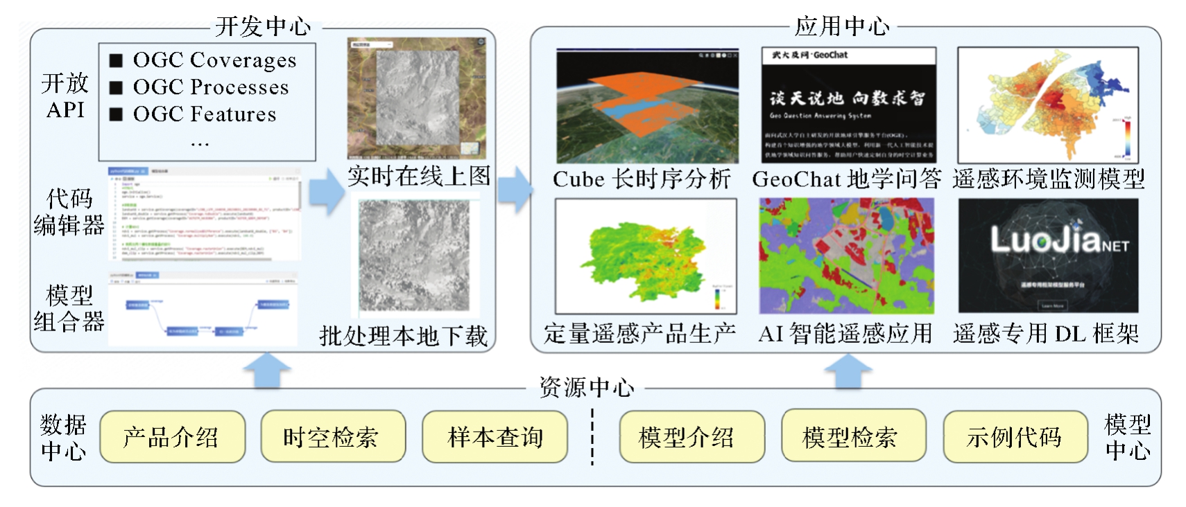
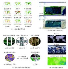
Fig. 9
OGE system data resource"

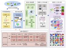
Fig. 10
OGE system analysis capability"

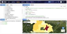
Fig. 11
Typical cases of spatio-temporal computational analytics in OGE"

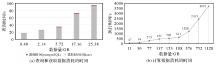
Fig. 12
OGE system large-scale data performance test results"
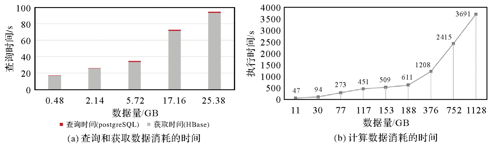
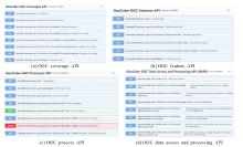
Fig. 13
OGC service interface implemented by OGE platform module"

Fig. 14
The mapping relationship between OGEScript script objects and OGC API series standards"

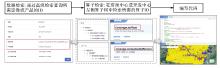
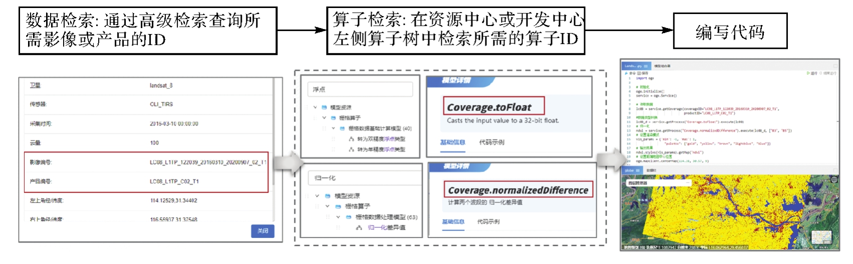
Fig. 15
OGE geographic analysis process (taking NDVI calculation as an example)"
| [1] | ZHAO Qiang, YU Le, DU Zhenrong, et al. An overview of the applications of earth observation satellite data: impacts and future trends[J]. Remote Sensing, 2022, 14(8): 1863. |
| [2] | LI Yansheng, MA Jiayi, ZHANG Yongjun. Image retrieval from remote sensing big data: a survey[J]. Information Fusion, 2021, 67: 94-115. |
| [3] | GUO Huadong. Big Earth Data: a new frontier in Earth and information sciences[J]. Big Earth Data, 2017, 1(1-2): 4-20. |
| [4] | 李德仁, 王密, 仵倩玉. 论智能遥感卫星的“快、准、灵”应用服务[J]. 先进小卫星技术(中英文), 2024(1): 1-9. |
| LI Deren, WANG Mi, WU Qianyu. Fast, accurate and smart applications of intelligent remote sensing satellites[J]. Advanced Small Satellite Technology, 2024(1): 1-9. | |
| [5] | LI Deren, WANG Mi, JIANG Jie. China's high-resolution optical remote sensing satellites and their mapping applications[J]. Geo-spatial Information Science, 2021, 24(1): 85-94. |
| [6] | CHEN Liangfu, LETU H, FAN Meng, et al. An introduction to the Chinese high-resolution Earth observation system: Gaofen-1~7 civilian satellites[J]. Journal of Remote Sensing, 2022, 2022: 1-14. |
| [7] | 李德仁. 从珞珈系列卫星到东方慧眼星座[J]. 武汉大学学报(信息科学版), 2023, 48(10): 1557-1565. |
| LI Deren. From the Luojia series satellites to the oriental smart eye constellation[J]. Geomatics and Information Science of Wuhan University, 2023, 48(10): 1557-1565. | |
| [8] | WULDER M A, LOVELAND T R, ROY D P, et al. Current status of Landsat program, science, and applications[J]. Remote Sensing of Environment, 2019, 225: 127-147. |
| [9] | NGUYEN M D, BAEZ-VILLANUEVA O M, BUI D D, et al. Harmonization of Landsat and Sentinel 2 for crop monitoring in drought prone areas: Case studies of Ninh Thuan (Vietnam) and Bekaa (Lebanon)[J]. Remote Sensing, 2020, 12(2): 281. |
| [10] | HONG Danfeng, LI Chenyu, ZHANG Bing, et al. Multimodal artificial intelligence foundation models: unleashing the power of remote sensing big data in earth observation[J]. The Innovation Geoscience, 2024, 2(1): 100055. |
| [11] | DIMITROVSKI I, KITANOVSKI I, KOCEV D, et al. Current trends in deep learning for earth observation: an open-source benchmark arena for image classification[J]. ISPRS Journal of Photogrammetry and Remote Sensing, 2023, 197: 18-35. |
| [12] |
李德仁. 展望大数据时代的地球空间信息学[J]. 测绘学报, 2016, 45(4): 379-384. DOI:.
doi: 10.11947/j.AGCS.2016.20160057 |
|
LI Deren. Towards geo-spatial information science in big data era[J]. Acta Geodaetica et Cartographica Sinica, 2016, 45(4): 379-384. DOI:.
doi: 10.11947/j.AGCS.2016.20160057 |
|
| [13] | LI Wenwen, HSU C Y. GeoAI for large-scale image analysis and machine vision: recent progress of artificial intelligence in geography[J]. ISPRS International Journal of Geo-Information, 2022, 11(7): 385. |
| [14] | LI Ying, ZHANG Haokui, XUE Xizhe, et al. Deep learning for remote sensing image classification: a survey[J]. Wiley Interdisciplinary Reviews: Data Mining and Knowledge Discovery, 2018, 8(6): e1264. |
| [15] | RAIHAN A. A comprehensive review of the recent advancement in integrating deep learning with geographic information systems[J]. Research Briefs on Information and Communication Technology Evolution, 2023, 9: 98-115. |
| [16] | ZHANG Bing, WU Yuanfeng, ZHAO Boya, et al. Progress and challenges in intelligent remote sensing satellite systems[J]. IEEE Journal of Selected Topics in Applied Earth Observations and Remote Sensing, 2022, 15: 1814-1822. |
| [17] | RUBIN K, RAMAMURTHY M. Update on the EarthCube initiative[C]//Proceedings of 2019 Geophysical Research Abstracts. [S.l.]: IEEE, 2019: 21. |
| [18] | KILLOUGH B. Overview of the open data cube initiative[C]//Proceedings of 2018 IEEE International Geoscience and Remote Sensing Symposium. Valencia: IEEE, 2018: 8629-8632. |
| [19] | YANG Liping, DRISCOL J, SARIGAI S, et al. Google earth engine and artificial intelligence (AI): a comprehensive review[J]. Remote Sensing, 2022, 14(14): 3253. |
| [20] | MONTOYA A V, BURBANO N M, MERO P C, et al. Google earth engine: a global analysis and future trends[J]. Remote Sensing, 2023, 15(14): 3675. |
| [21] | Looking back on a year of deeper connectivity acrossearth engine and cloud[EB/OL]. [2025-02-25]. https://cloud.google.com/blog/topics/sustainability/look-back-at-a-year-of-earth-engine-advancements. |
| [22] | YUE Peng, WANG Kaixuan, XU Hanwen, et al. From geospatial data cube to AI cube: the open geospatial engine (OGE) approach[J]. ISPRS Annals of the Photogrammetry, Remote Sensing and Spatial Information Sciences, 2024, 10: 441-446. |
| [23] | WANG Shaowen, ARMSTRONG M P. A theoretical approach to the use of cyberinfrastructure in geographical analysis[J]. International Journal of Geographical Information Science, 2009, 23(2): 169-193. |
| [24] | 乐鹏. 高性能地理计算[M]. 北京: 科学出版社, 2021. |
| YUE Peng. High performance geographic computing[M]. Beijing: Science Press, 2021. | |
| [25] | YUE Peng, SHANGGUAN Boyi, HU Lei, et al. Towards a training data model for artificial intelligence in earth observation[J]. International Journal of Geographical Information Science, 2022, 36(11): 2113-2137. |
| [26] | GAO Fan, YUE Peng, CAO Zhipeng, et al. A multi-source spatio-temporal data cube for large-scale geospatial analysis[J]. International Journal of Geographical Information Science, 2022, 36(9): 1853-1884. |
| [27] | LEWIS A, LACEY J, MECKLENBURG S, et al. CEOS analysis ready data for land (CARD4L) overview[C]//Proceedings of 2018 IEEE International Geoscience and Remote Sensing Symposium. Valencia: IEEE, 2018: 7407-7410. |
| [28] | OGC disaster pilot 2021 engineering repor[EB/OL]. [2025-02-25]. https://docs.ogc.org/per/21-064.html. |
| [29] | CAO Zhipeng, JIANG Liangcun, YUE Peng, et al. A large scale training sample database system for intelligent interpretation of remote sensing imagery[J]. Geo-spatial Information Science, 2024, 27(5): 1489-1508. |
| [30] | 高凡, 乐鹏, 姜良存, 等. GeoCube:面向大规模分析的多源对地观测时空立方体[J]. 遥感学报, 2022, 26(6): 1051-1066. |
| GAO Fan, YUE Peng, JIANG Liangcun, et al. GeoCube: a spatio-temporal cube toward massive and multi-source EO data analysis[J]. National Remote Sensing Bulletin, 2022, 26(6): 1051-1066. | |
| [31] | LIU Ruixiang, YUE Peng, SHANGGUAN Boyi, et al. RTGDC: a real-time ingestion and processing approach in geospatial data cube for digital twin of earth[J]. International Journal of Digital Earth, 2024, 17(1): 2365386. |
| [32] | YUE Peng, GAO Fan, SHANGGUAN Boyi, et al. A machine learning approach for predicting computational intensity and domain decomposition in parallel geoprocessing[J]. International Journal of Geographical Information Science, 2020, 34(11): 2243-2274. |
| [33] | 高凡, 路威, 甘麟露. 基于卷积神经网络的地理空间域计算强度预测与分解方法[J/OL]. 武汉大学学报(信息科学版), 2024: 1-16. [2024-11-06]. https://kns.cnki.net/KCMS/detail/detail.aspx?filename=WHCH20241106001&dbname=CJFD&dbcode=CJFQ. |
| GAO Fan, LU Wei, GAN Linlu. Computational strength prediction and decomposition method in geospatial domain based on convolutional neural network[J/OL]. China Industrial Economics, 2024: 1-16. [2024-11-06]. https://kns.cnki.net/KCMS/detail/detail.aspx?filename=WHCH20241106001&dbname=CJFD&dbcode=CJFQ. | |
| [34] | ZHANG Zhan, ZHANG Mi, GONG Jianya, et al. LuoJiaAI: a cloud-based artificial intelligence platform for remote sensing image interpretation[J]. Geo-spatial Information Science, 2023, 26(2): 218-241. |
| [35] | LIU Shuaiqi, YUE Peng, XU Hanwen, et al. An OGC TrainingDML-AI approach for making EO training datasets ready in deep learning frameworks[C]//Proceedings of the 11th International Conference on Agro-Geoinformatics (Agro-Geoinformatics). Wuhan: IEEE, 2023: 1-6. |
| [36] | 乐鹏, 刘瑞祥, 上官博屹, 等. 地理人工智能样本:模型、质量与服务[J]. 武汉大学学报(信息科学版), 2023, 48(10): 1616-1631. |
| YUE Peng, LIU Ruixiang, SHANGGUAN Boyi, et al. GeoAI training data: model, quality, and services[J]. Geomatics and Information Science of Wuhan University, 2023, 48(10): 1616-1631. |
| [1] | LIU Jingnan, LUO Yarong, GUO Chi, GAO Kefu. PNT intelligence and intelligent PNT [J]. Acta Geodaetica et Cartographica Sinica, 2022, 51(6): 811-828. |
| Viewed | ||||||
|
Full text |
|
|||||
|
Abstract |
|
|||||