

Acta Geodaetica et Cartographica Sinica ›› 2026, Vol. 55 ›› Issue (9): 1582-1598.doi: 10.11947/j.AGCS.2026.20260244
• Photogrammetry and Remote Sensing • Previous Articles Next Articles
Xiaohu Lin1( ), Tao Yan2, Bisheng Yang2(), Chi Chen2, Yinan Gao1, Xiang Wang1
Received:2026-06-23
Revised:2026-09-10
Online:2026-10-28
Published:2026-10-28
Contact:
Bisheng Yang
E-mail:xhlin214@xust.edu.cn;bshyang@whu.edu.cn
About author:Lin Xiaohu (1989—), male, PhD, associate professor, majors in multi-source fusion-based intelligent sensing and monitoring for complex environments. E-mail: xhlin214@xust.edu.cn
Supported by:CLC Number:
Xiaohu Lin, Tao Yan, Bisheng Yang, Chi Chen, Yinan Gao, Xiang Wang. An open-vocabulary semantic-enhanced 3DGS-SLAM method for complex underground spaces[J]. Acta Geodaetica et Cartographica Sinica, 2026, 55(9): 1582-1598.
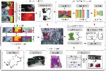
Fig. 1
Framework of the proposed open-vocabulary semantic 3DGS-SLAM"

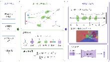
Fig. 2
Semantic Gaussian mapping and optimization"

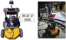
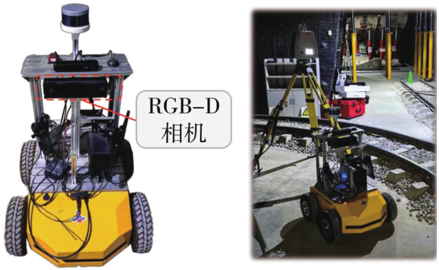
Fig. 3
Data acquisition platform and experimental scenes"
Tab. 1
Experimental devices and specifications"
| 设备 | 类型 | 规格 |
|---|---|---|
| 深度相机 | Kinect v2 | 采样率:10 Hz |
| 分辨率:512×424像素 | ||
| 水平70°,垂直60° | ||
| 控制台 | Autolabor-PC | CPU:AMDRyzen33200G/DDR4 8 GB |
| 移动机器人 | Autolabor-Pro1 | 设备模式:四驱 |
| 位移速度:0.5~1.5 m/s | ||
| 角速度:0.56 rad/s | ||
| 台式计算机 | 自定义 | CPU:Intel i7-14700K |
| GPU:NVIDIA GeForce RTX 4090D DDR5 64 GB | ||
| 操作系统:Ubuntu 18.04 |
Tab. 2
Statistics of the field test dataset"
| 场景 | 轨迹长度/m | 面积/m2 | 帧数量 | 场景特征 |
|---|---|---|---|---|
| 采掘巷道 | 24.8 | 78.9 | 1469 | 低光照,运动模糊 |
| 运输巷道 | 27.0 | 74.6 | 1596 | 低光照,重复纹理 |
| 行人通道 | 36.2 | 92.5 | 2230 | 低光照,大场景 |
| 地质巷道 | 29.4 | 101.3 | 1674 | 低光照,弱纹理 |
| 废弃车库 | 16.5 | 45.8 | 832 | 低光照,复杂结构 |
| 电动车库 | 28.0 | 88.5 | 1622 | 低光照,局部遮挡 |
| 水泵房 | 20.5 | 59.4 | 1141 | 重复纹理 |
| 配电室 | 19.1 | 43.8 | 1609 | 遮挡,光照变化 |
| 简报室 | 18.7 | 38.4 | 624 | 白墙,弱纹理 |
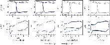
Fig. 4
Qualitative comparison between estimated and reference trajectories in underground scenes"
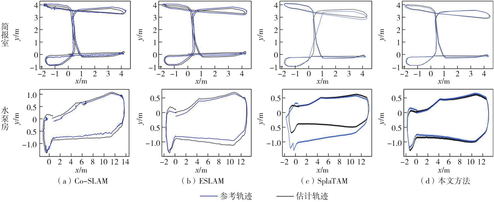
Tab. 3
Quantitative trajectory tracking accuracy comparison on the underground dataset"
| 方法 | 煤矿场景 | 车库场景 | 地下室场景 | ||||||
|---|---|---|---|---|---|---|---|---|---|
| 采掘巷道 | 运输巷道 | 行人通道 | 地质巷道 | 废弃车库 | 电动车库 | 水泵房 | 配电室 | 简报室 | |
| NICE-SLAM | 18.9 | 16.4 | 14.8 | 29.7 | 12.2 | 26.1 | 9.4 | 7.8 | 10.8 |
| Co-SLAM | 11.0 | 18.3 | 13.3 | 12.6 | 17.4 | 10.5 | 8.9 | 16.9 | 10.3 |
| ESLAM | 9.9 | 10.5 | 7.4 | 10.5 | 8.3 | 7.9 | 7.9 | 5.1 | 9.7 |
| SplaTAM | 12.6 | 22.7 | 18.2 | 24.4 | 16.1 | 20.2 | 11.9 | 12.4 | 11.0 |
| MonoGS | 15.2 | 21.4 | 15.7 | 14.4 | 14.8 | 13.6 | 9.8 | 11.8 | 19.5 |
| GS-ICP SLAM | 9.5 | 11.0 | 7.1 | 8.2 | 11.9 | 10.8 | 6.9 | 10.6 | 11.7 |
| RTG-SLAM | 9.8 | 8.7 | 6.9 | 9.1 | 8.9 | 8.9 | 9.4 | 7.6 | 9.6 |
| GS3LAM | 9.5 | 7.9 | 5.2 | 8.6 | 9.0 | 9.8 | 9.4 | 7.7 | 10.1 |
| 前序方法 | 9.1 | 7.6 | 4.8 | 8.2 | 9.6 | 7.7 | 8.9 | 5.4 | 9.6 |
| 本文方法 | 9.2 | 7.7 | 5.2 | 8.2 | 9.5 | 7.6 | 8.8 | 5.6 | 9.6 |
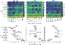
Fig. 5
Quantitative rendering performance comparison on the underground dataset"
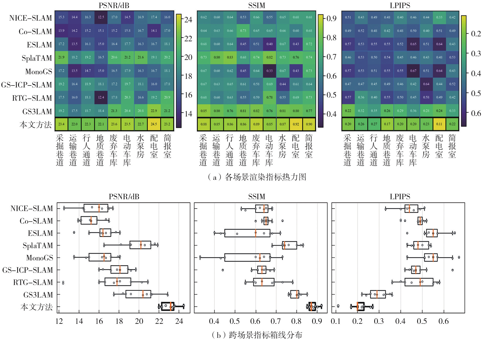
Fig. 6
Qualitative rendering performance comparison on the underground dataset"
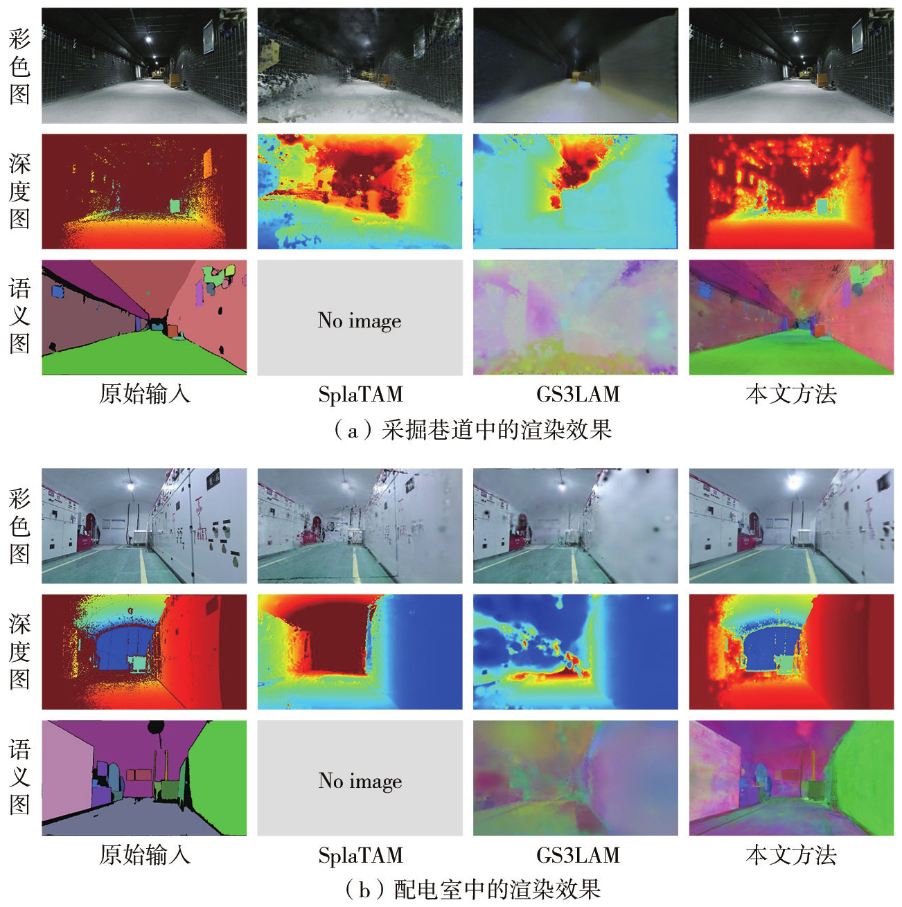
Fig. 7
Reconstruction comparison in additional scenes"
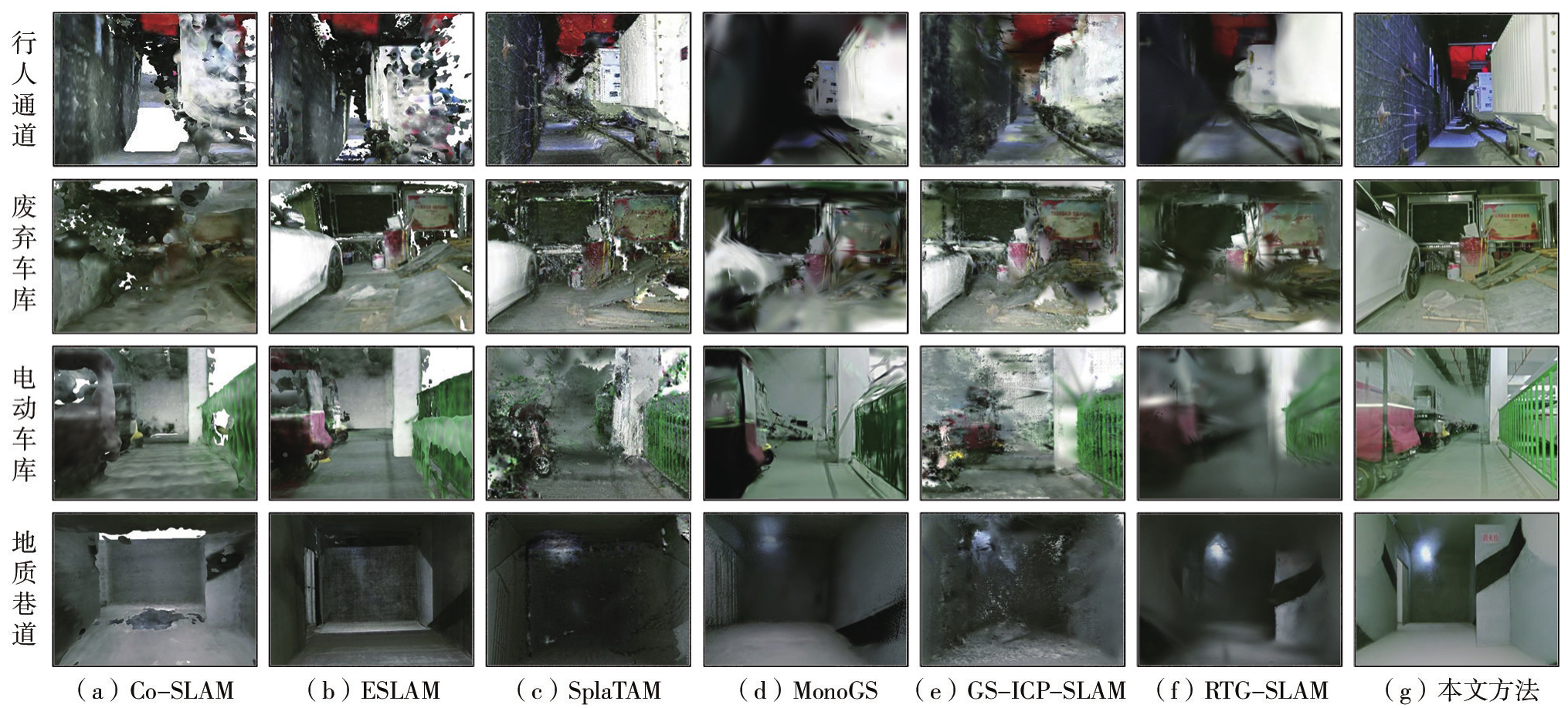
Fig. 8
Three-dimensional reconstruction results of representative scenes"
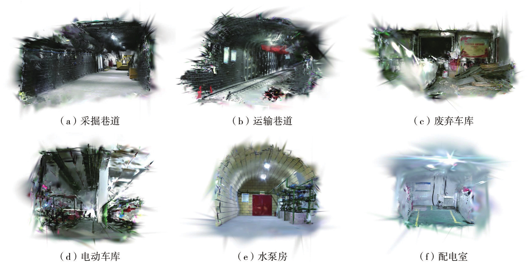
Fig. 9
Semantic reconstruction results on the underground dataset"
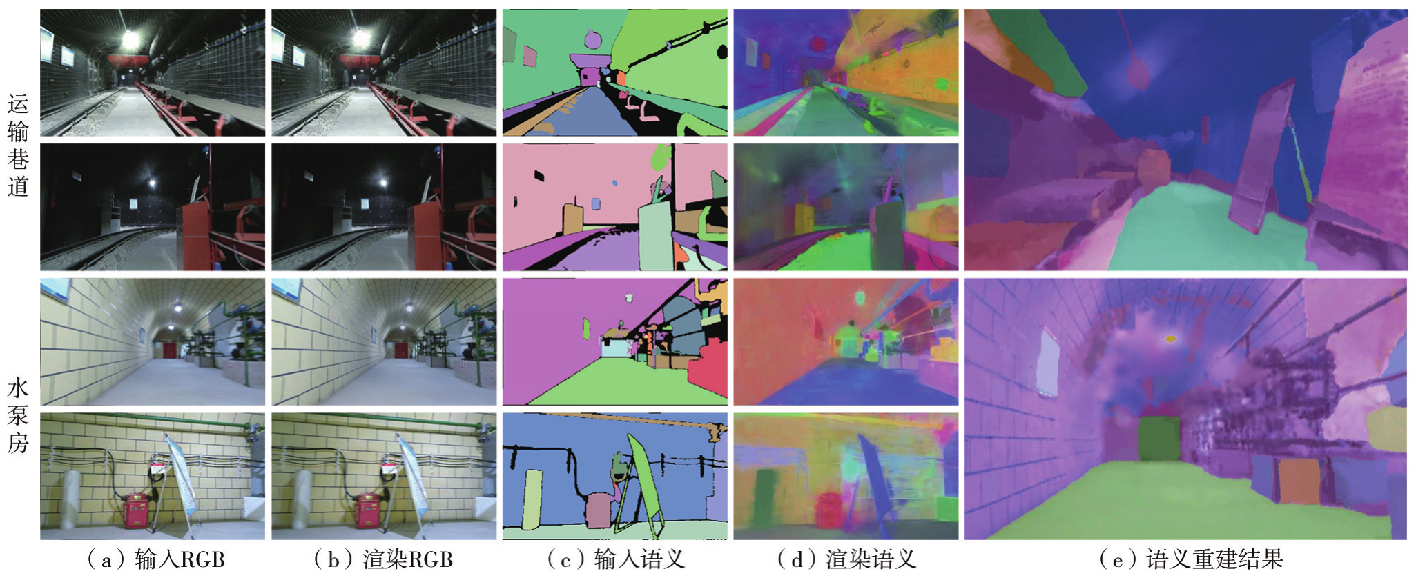
Fig. 10
The open-vocabulary query functionality"
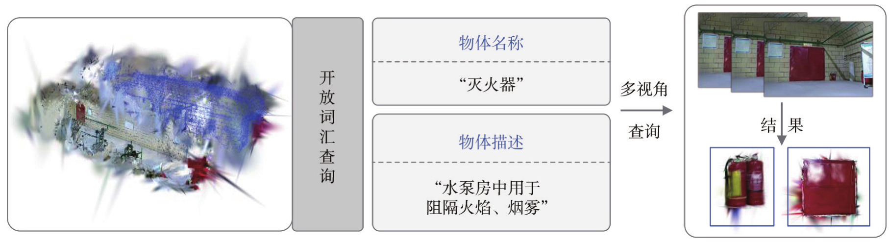
Fig. 11
Rendering results on the ScanNet dataset"

Tab. 4
Tracking and rendering performance comparison on the ScanNet dataset"
| 方法 | 指标 | scene0062_00 | scene0097_00 | scene0200_00 |
|---|---|---|---|---|
| SplaTAM | PSNR/dB | 21.0 | 26.9 | 21.3 |
| SSIM | 0.80 | 0.90 | 0.79 | |
| LPIPS | 0.27 | 0.22 | 0.36 | |
| ATE/cm | 12.1 | 11.0 | 11.9 | |
| SGS-SLAM | PSNR/dB | 20.8 | 27.2 | 21.1 |
| SSIM | 0.81 | 0.89 | 0.75 | |
| LPIPS | 0.24 | 0.25 | 0.38 | |
| ATE/cm | 11.3 | 10.9 | 11.3 | |
| GS3LAM | PSNR/dB | 22.1 | 28.3 | 22.4 |
| SSIM | 0.82 | 0.90 | 0.80 | |
| LPIPS | 0.22 | 0.21 | 0.31 | |
| ATE/cm | 11.6 | 10.2 | 11.2 | |
| 本文方法 | PSNR/dB | 22.9 | 29.5 | 23.0 |
| SSIM | 0.84 | 0.92 | 0.83 | |
| LPIPS | 0.20 | 0.19 | 0.29 | |
| ATE/cm | 11.3 | 10.2 | 11.0 |
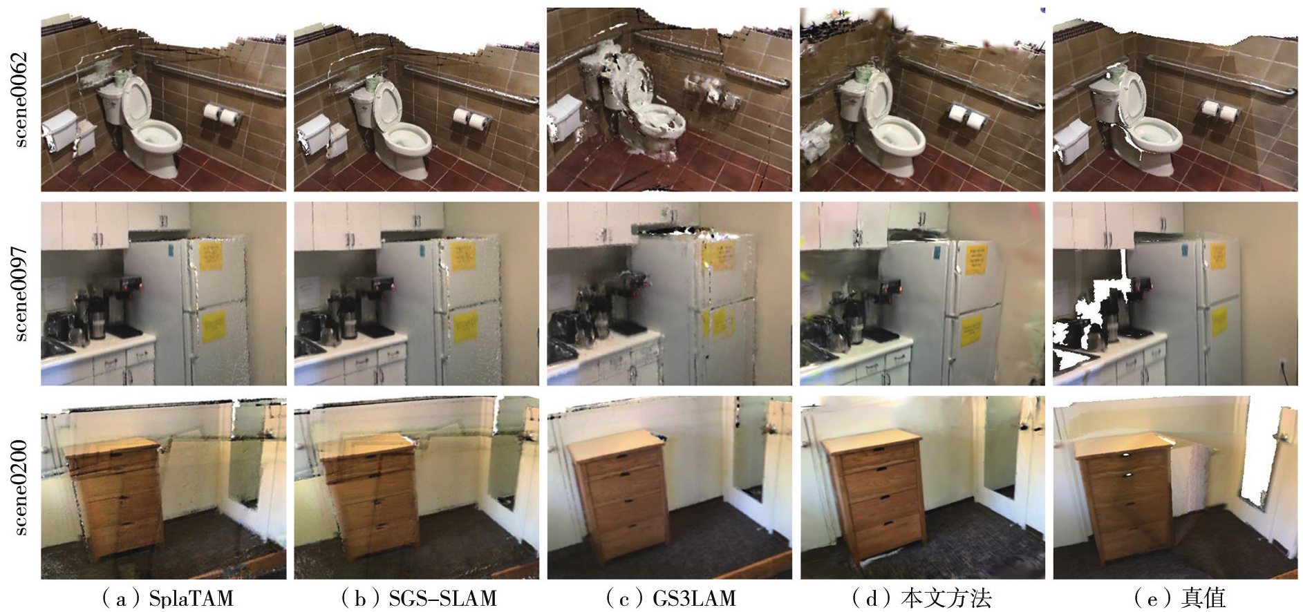
Fig. 12
Qualitative reconstruction comparison on the ScanNet dataset"
Tab. 5
3D open-vocabulary segmentation performance comparison"
| 方法 | scene0062_00 | scene0097_00 | scene0200_00 | 平均值 | ||||
|---|---|---|---|---|---|---|---|---|
| mIoU | mAcc | mIoU | mAcc | mIoU | mAcc | mIoU | mAcc | |
| LangSplat | 3.51 | 9.58 | 4.49 | 11.27 | 3.14 | 8.79 | 3.71 | 9.88 |
| OpenGaussian | 28.99 | 46.53 | 28.51 | 48.62 | 26.98 | 47.09 | 28.16 | 47.41 |
| 本文方法 | 39.12 | 57.83 | 38.27 | 54.09 | 39.84 | 63.97 | 39.08 | 58.63 |
Tab. 6
Effects of semantic feature compression on GPU memory consumption and runtime efficiency"
| 语义表示方式 | 峰值显存/GB | FPS | mIoU/(%) |
|---|---|---|---|
| 原始CLIP特征 | 显存溢出 | — | — |
| 128维语义嵌入 | 15.9 | 7.9 | 39.02 |
| 本文方法 | 12.3 | 8.8 | 39.08 |
Tab. 7
Effect of introducing semantic loss in the tracking stage"
| 跟踪设置 | ATE/cm | FPS |
|---|---|---|
| 不引入语义损失 | 7.9 | 8.8 |
| 引入语义损失 | 8.0 | 6.9 |
Tab. 8
Ablation of uncertainty priors and sensitivity of temporal smoothing"
| 消融试验 | 设置 | mIoU | mAcc |
|---|---|---|---|
| 不确定性先验 | 仅增强残差 | 35.62 | 54.83 |
| 仅深度置信度 | 36.34 | 55.71 | |
| 双先验联合 | 37.11 | 56.72 | |
| 时间平滑 | ρ=0.5 | 38.24 | 57.66 |
| ρ=0.8 | 39.08 | 58.63 | |
| ρ=0.9 | 38.61 | 58.05 |
Tab. 9
Ablation study of key modules on the ScanNet dataset"
| 设置 | 语义嵌入 | 不确定性权重 | 时间平滑 | PSNR/dB | SSIM | LPIPS | mIoU/(%) |
|---|---|---|---|---|---|---|---|
| 几何+外观建图 | × | × | × | 24.0 | 0.78 | 0.27 | — |
| +开放词汇语义嵌入 | √ | × | × | 24.3 | 0.80 | 0.27 | 34.52 |
| +语义不确定性权重 | √ | √ | × | 24.7 | 0.83 | 0.25 | 37.11 |
| 本文方法 | √ | √ | √ | 25.1 | 0.86 | 0.23 | 39.08 |
| [1] | Lin Xiaohu, Yang Xin, Yao Wanqiang, et al. Graph-based adaptive weighted fusion SLAM using multimodal data in complex underground spaces[J]. ISPRS Journal of Photogrammetry and Remote Sensing, 2024, 217: 101-119. |
| [2] | Kim H, Choi Y. 3D location estimation and tunnel mapping of autonomous driving robots through 3D point cloud registration on underground mine rampways[J]. Underground Space, 2025, 22: 1-20. |
| [3] | Li Yufei, Xie Yakun, Chen Mingzhen, et al. A multi-level semantic constraint approach for highway tunnel scene twin modeling[J]. Journal of Geodesy and Geoinformation Science, 2025, 8(2): 37-56. |
| [4] | Li Xingxing, Zhang Xiaohong, Niu Xiaoji, et al. Progress and achievements of multi-sensor fusion navigation in China during 2019—2023[J]. Journal of Geodesy and Geoinformation Science, 2023, 6(3): 102-114. |
| [5] |
郭迟, 刘阳, 罗亚荣, 等. 图像语义信息在视觉SLAM中的应用研究进展[J]. 测绘学报, 2024, 53(6): 1057-1076. DOI: .
doi: 10.11947/j.AGCS.2024.20230259 |
|
Guo Chi, Liu Yang, Luo Yarong, et al. Research progress in the application of image semantic information in visual SLAM[J]. Acta Geodaetica et Cartographica Sinica, 2024, 53(6): 1057-1076. DOI: .
doi: 10.11947/j.AGCS.2024.20230259 |
|
| [6] |
张继贤, 刘飞. 视觉SLAM环境感知技术现状与智能化测绘应用展望[J]. 测绘学报, 2023, 52(10): 1617-1630. DOI: .
doi: 10.11947/j.AGCS.2023.20220240 |
|
Zhang Jixian, Liu Fei. Review of visual SLAM environment perception technology and intelligent surveying and mapping application[J]. Acta Geodaetica et Cartographica Sinica, 2023, 52(10): 1617-1630. DOI: .
doi: 10.11947/j.AGCS.2023.20220240 |
|
| [7] |
蔺小虎, 杨鑫, 姚顽强, 等. 面向复杂地下空间的多源传感器数据动态加权融合SLAM方法[J]. 测绘学报, 2025, 54(3): 523-535. DOI: .
doi: 10.11947/j.AGCS.2025.20230586 |
|
Lin Xiaohu, Yang Xin, Yao Wanqiang, et al. A dynamic weighted fusion SLAM method using multi-source sensor data in complex underground spaces[J]. Acta Geodaetica et Cartographica Sinica, 2025, 54(3): 523-535. DOI: .
doi: 10.11947/j.AGCS.2025.20230586 |
|
| [8] | 高毅楠, 姚顽强, 蔺小虎, 等. 煤矿井下多重约束的视觉SLAM关键帧选取方法[J]. 煤炭学报, 2024, 49(S1): 472-482. |
| Gao Yinan, Yao Wanqiang, Lin Xiaohu, et al. Visual SLAM keyframe selection method with multiple constraints in underground coal mines[J]. Journal of China Coal Society, 2024, 49(S1): 472-482. | |
| [9] | 陈荣瀚, 丛杨, 刘佳悦, 等. 欠定场景下基于3D高斯溅射的3维重建综述[J/OL]. 机器人, 1-15[2026-09-11]. https://doi.org/10.13973/j.cnki.robot.250076. |
| Chen Ronghan, Cong Yang, Liu Jiayue, et al. 3D Gaussian splatting-based 3D reconstruction in underdetermined scenarios: a review[J/OL]. Robot, 1-15[2026-09-11]. https://doi.org/10.13973/j.cnki.robot.250076. | |
| [10] | 赵歆祎, 芮胜阳, 郭莉莎, 等. 基于深度代理与3DGS的单目稠密视觉SLAM算法[J]. 计算机工程与应用, 2026, 62(15): 170-182. |
| Zhao Xinyi, Rui Shengyang, Guo Lisha, et al. Monocular dense visual SLAM based on depth proxy and 3DGS[J]. Computer Engineering and Applications, 2026, 62(15): 170-182. | |
| [11] | Campos C, Elvira R, Rodriguez J J G, et al. ORB-SLAM3: an accurate open-source library for visual, visual - inertial, and multimap SLAM[J]. IEEE Transactions on Robotics, 2021, 37(6): 1874-1890. |
| [12] | Newcombe R A, Izadi S, Hilliges O, et al. KinectFusion: real-time dense surface mapping and tracking[C]//Proceedings of the 10th IEEE International Symposium on Mixed and Augmented Reality. Basel: IEEE, 2011: 127-136. |
| [13] | Dai A, Nieвner M, Zollhöfer M, et al. BundleFusion: real-time globally consistent 3D reconstruction using on-the-fly surface reintegration[J]. ACM Transactions on Graphics, 2017, 36(4): 1. |
| [14] | Wang Hengyi, Wang Jingwen, Agapito L. Co-SLAM: joint coordinate and sparse parametric encodings for neural real-time SLAM[C]//Proceedingsof2023IEEE/CVFConferenceonComputerVisionandPatternRecognition. Vancouver: IEEE, 2023: 13293-13302. |
| [15] | Johari M M, Carta C, Fleuret F. ESLAM: efficient dense SLAM system based on hybrid representation of signed distance fields[C]//Proceedings of 2023 IEEE/CVF Conference on Computer Vision and Pattern Recognition. Vancouver: IEEE, 2023: 17408-17419. |
| [16] | Zhu Zihan, Peng Songyou, Larsson Viktor, et al. NICE-SLAM: neural implicit scalable encoding for SLAM[C]//Proceedings of 2022 IEEE/CVF Conference on Computer Vision and Pattern Recognition. New Orleans: IEEE, 2022: 12776-12786. |
| [17] | Kerbl B, Kopanas G, Leimkuehler T, et al. 3D Gaussian splatting for real-time radiance field rendering[J]. ACM Transactions on Graphics, 2023, 42(4): 131-139. |
| [18] | 吕晓玲, 刘鑫翀, 张明路, 等. 融合自适应点云分布与多帧深度信息的三维高斯SLAM[J]. 激光与光电子学进展, 2026, 63(12): 234-244. |
| Lü Xiaoling, Liu Xinchong, Zhang Minglu, et al. Three-dimensional Gaussian SLAM integrating adaptive point cloud distribution and multi-frame depth information[J]. Laser & Optoelectronics Progress, 2026, 63(12): 234-244. | |
| [19] | 周小渊, 党淑雯, 陈丽. 改进位姿估计和高斯剪枝策略的3DGS-SLAM算法[J]. 激光与光电子学进展, 2026, 63(4): 196-206. |
| Zhou Xiaoyuan, Dang Shuwen, Chen Li. 3DGS-SLAM algorithm with enhanced pose estimation and an optimized Gaussian pruning strategy[J]. Laser & Optoelectronics Progress, 2026, 63(4): 196-206. | |
| [20] | Matsuki H, Murai R, Kelly P H J, et al. Gaussian splatting SLAM[C]//Proceedings of 2024 IEEE/CVF Conference on Computer Vision and Pattern Recognition. Seattle: IEEE, 2024: 18039-18048. |
| [21] | Ha S, Yeon J, Yu H. Rgbd gs-icp slam[C]//Proceedings of 2025 Computer Vision. Cham: Springer Nature Switzerland, 2025: 180-197. |
| [22] | Peng Zhexi, Shao Tianjia, Liu Yong, et al. RTG-SLAM: real-time 3D reconstruction at scale using Gaussian splatting[C]//Proceedings of 2024 Special Interest Group on Computer Graphics and Interactive Techniques Conference Conference Papers. Denver: ACM Press, 2024: 1-11. |
| [23] | Keetha N, Karhade J, Jatavallabhula K M, et al. SplaTAM: splat, track & map 3D Gaussians for dense RGB-D SLAM[C]//Proceedings of 2024 IEEE/CVF Conference on Computer Vision and Pattern Recognition. Seattle: IEEE, 2024: 21357-21366. |
| [24] | Li Linfei, Zhang Lin, Wang Zhong, et al. GS3LAM: Gaussian semantic splatting SLAM[C]//Proceedings of the 32nd ACM International Conference on Multimedia. Melbourne VIC Australia. ACM, 2024: 3019-3027. |
| [25] | Li Mingrui, Liu Shuhong, Zhou Heng, et al. SGS-SLAM: semantic Gaussian splatting for neural dense SLAM[C]//Proceedings of 2025 Computer Vision. Cham: Springer Nature Switzerland, 2025: 163-179. |
| [26] | Jiang Zhiyue, Lin Xiaohu, Yao Wanqiang, et al. A robust LiDAR localization method for complex underground spaces using Gaussianblurred normal distributions transform maps[J]. IEEE Transactions on Instrumentation and Measurement, 2025, 74: 9541713. |
| [27] | Yan Tao, Lin Xiaohu, Yao Wanqiang, et al. RGB-D perception-enhanced 3D Gaussian splatting SLAM: a robust framework for mapping underground spaces[J]. IEEE Transactions on Visualization and Computer Graphics, 2026, 32(7): 6695-6711. |
| [28] | 蔺小虎, 马艾强, 姚顽强, 等. 融合强度特征与黎曼流形地面约束的煤矿井下稳健激光SLAM方法[J/OL]. 煤炭学报, 1-16[2026-09-11]. https://doi.org/10.13225/j.cnki.jccs.2025.1380. |
| Lin Xiaohu, Ma Aiqiang, Yao Wanqiang, et al. A robust LiDAR SLAM method for underground coal mines integrating intensity features and riemannian manifold-based ground constraints[J/OL]. Journal of China Coal Society, 1-16[2026-09-11]. https://doi.org/10.13225/j.cnki.jccs.2025.1380. | |
| [29] | McCormac J, Handa A, Davison A, et al. SemanticFusion: Dense 3D semantic mapping with convolutional neural networks[C]//Proceedings of 2017 IEEE International Conference on Robotics and Automation. Singapore: IEEE, 2017: 4628-4635. |
| [30] | Zhu Siting, Wang Guangming, Blum H, et al. SNI-SLAM: semantic neural implicit SLAM[C]//Proceedings of 2024 IEEE/CVF Conference on Computer Vision and Pattern Recognition. Seattle: IEEE, 2024: 21167-21177. |
| [31] | Yamazaki K, Hanyu T, Vo K, et al. Open-fusion: real-time open-vocabulary 3D mapping and queryable scene representation[C]//Proceedings of 2024 IEEE International Conference on Robotics and Automation. Yokohama: IEEE, 2024: 9411-9417. |
| [32] | Qin Minghan, Li Wanhua, Zhou Jiawei, et al. LangSplat: 3D language Gaussian splatting[C]//Proceedings of 2024 IEEE/CVF Conference on Computer Vision and Pattern Recognition. Seattle: IEEE, 2024: 20051-20060. |
| [33] | Jatavallabhula K, Kuwajerwala A, Gu Q, et al. ConceptFusion: open-set multimodal 3D mapping[C]//Proceedings of 2023 Robotics: Science and Systems XIX. Robotics: Science and Systems Foundation, 2023. |
| [34] | Kerr J, Kim C M, Goldberg K, et al. LERF: language embedded radiance fields[C]//Proceedings of 2023 IEEE/CVF International Conference on Computer Vision. Paris: IEEE, 2023: 19672-19682. |
| [35] | Wu Yanmin, Meng Jiarui, Li Haijie, et al. OpenGaussian: towards point-level 3D Gaussian-based open vocabulary understanding[J]. Advances in neural information processing systems, 2024, 37: 19114-19138. |
| [36] | Tie Muer, Wei Julong, Wu Ke, et al. O_2V-mapping: online open-vocabulary mapping with Neural implicit representation[C]//Proceedings of 2024 European Conference on Computer Vision. Springer, 2024: 318-333. |
| [37] | Deng Yinan, Yue Yufeng, Dou Jianyu, et al. OmniMap: a general mapping framework integrating optics, geometry, and semantics[J]. IEEE Transactions on Robotics, 2025, 41: 6549-6569. |
| [38] | Hu Jiarui, Chen Xianhao, Feng Boyin, et al. CG-SLAM: efficient dense RGB-D SLAM in a Consistent uncertainty-aware 3D Gaussian field[C]//Proceedings of 2024 European Conference on Computer Vision. Cham: Springer, 2024: 93-112. |
| [39] | 蔺小虎, 闫涛, 毛清华, 等. 多维度视觉感知增强的煤矿机器人高精度三维高斯溅射SLAM方法[J]. 煤炭学报, 2025, 50(10): 4609-4623. |
| Lin Xiaohu, Yan Tao, Mao Qinghua, et al. Multidimensional visual perception-enhanced high-precision 3DGS SLAM for underground coal mine robots[J]. Journal of China Coal Society, 2025, 50(10): 4609-4623. | |
| [40] | Dai A, Chang A X, Savva M, et al. ScanNet: richly-annotated 3D reconstructions of indoor scenes[C]//Proceedings of 2017 IEEE Conference on Computer Vision and Pattern Recognition. Honolulu: IEEE, 2017: 2432-2443. |
| [1] | Xiaohu LIN, Xin YANG, Wanqiang YAO, Hongwei MA, Bolin MA, Xiongwei MA. A dynamic weighted fusion SLAM method using multi-source sensor data in complex underground spaces [J]. Acta Geodaetica et Cartographica Sinica, 2025, 54(3): 523-535. |
| [2] | HAO Tong, WANG Xiaofeng, FENG Tiantian, LU Ping, QIAO Gang, XIE Huan, LI Rongxing. Intelligent and multi-scale surveying of key areas and processes of the Earth system [J]. Acta Geodaetica et Cartographica Sinica, 2021, 50(8): 1084-1095. |
| Viewed | ||||||
|
Full text |
|
|||||
|
Abstract |
|
|||||
