

Acta Geodaetica et Cartographica Sinica ›› 2025, Vol. 54 ›› Issue (9): 1664-1676.doi: 10.11947/j.AGCS.2025.20250092
• Photogrammetry and Remote Sensing • Previous Articles Next Articles
Kai YAN1,2,3( ), Jianming XU1,2, Qiao WANG1,2()
Received:2025-03-02
Revised:2025-09-15
Online:2025-10-10
Published:2025-10-10
Contact:
Qiao WANG
E-mail:kaiyan@bnu.edu.cn;wangqiao@bnu.edu.cn
About author:YAN Kai (1988—), male, PhD, associate professor, majors in real-time remote sensing and quantitative remote sensing. E-mail: kaiyan@bnu.edu.cn
Supported by:CLC Number:
Kai YAN, Jianming XU, Qiao WANG. Earth surface anomaly detection based on lightweight large vision model features in remotely sensed imagery[J]. Acta Geodaetica et Cartographica Sinica, 2025, 54(9): 1664-1676.
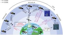
Fig. 1
The bottlenecks of traditional surface anomaly detection methods in on-orbit computing environment"

Tab. 1
Review on instantiate approaches and problems of existing methods"
| 方法类型 | 变量 | 实例化方法 |
|---|---|---|
| 低阶变化检测 | P | 像元值/低阶特征[ |
| d | 向量空间度量 | |
| o(x),τ | 像素尺度分析 | |
| 深度变化检测 | P | 深度神经网络特征 |
| d | 向量空间度量 | |
| o(x),τ | 影像块尺度分析 | |
| 异常检测 | P | 像元值/低阶特征的统计模型[ |
| d | 概率空间度量[ | |
| o(x),τ | 像素尺度分析 |
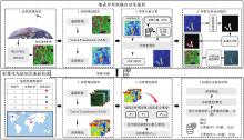
Fig. 2
Flowchart of the proposed method"

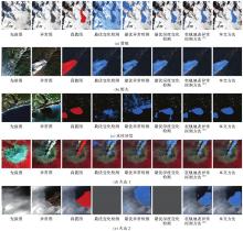
Fig. 3
Visual detection results comparison among different methods"

Tab. 2
Detail description on experimental dataset"
| 数据集类型 | 经纬度 | 先验图 | 异常图 | 特点 |
|---|---|---|---|---|
| 滑坡 | 43.57°S,170.17°E | 2012-03-13 EO-1 TOA(真彩色) | 2013-02-05 EO-1 TOA(真彩色) | 2013年奥拉基山滑坡,滑坡区域比较有代表性且明显 |
| 野火 | 39.81°N,121.45°E | 2017-11 Landsat-8中值合成(真彩色) | 2018-11-08 Landsat-8 TOA(真彩色) | 2018年加州天堂镇附近火灾事件,同时捕捉到燃烧区、过火区和浓烟,比较能代表野火事件 |
| 水体异常 | 34.64°N,77.07°W | 2017-11 Landsat-8中值合成(真彩色) | 2018-09-19 Landsat-8 TOA(真彩色) | 2018年佛罗伦萨洪水引发的水体异常事件,相较其他事件异常程度较弱 |
| 火山1 | 19.02°N,98.62°W | 2023-02 Landsat-8中值合成(标准假彩色) | 2024-02-28 Landsat-8 TOA(标准假彩色) | (1)波波卡特佩特火山喷发,具有明显的火山羽流,能作为火山活动的代表样本 |
| (2)采用标准假彩色合成,检验不同波段组合下的工作效果 | ||||
| 火山2 | 56.05°N,160.63°E | 2022-11-01 Landsat-8TOA(真彩色) | 2023-11-01 Landsat-8 TOA(真彩色) | 克柳切夫火山喷发,先验图和异常图在同一天获取,但空间上不匹配,可以测试算法在应用上的灵活性 |
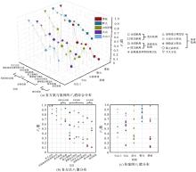
Fig. 4
Quantitative comparison on detection accuracy"

Tab. 3
Quantitative comparisons between different prior construction methods"
| 方法 | 参数 | 滑坡 | 野火 | 水体异常 | 火山1 | 火山2 |
|---|---|---|---|---|---|---|
| 深度变化检测(余弦距离) | F1值 | 0.653 | 0.925 | 0.695 | 0.657 | — |
| 数据量/KB | 4096 | |||||
| 深度变化检测(欧氏距离) | F1值 | 0.653 | 0.925 | 0.695 | 0.657 | — |
| 数据量/KB | 4096 | |||||
| 孤立森林 | F1值 | 0.353 | 0.709 | 0.572 | 0.434 | 0.651 |
| 数据量/KB | 208.54 | 213.20 | 212.83 | 209.67 | 220.14 | |
| 压缩率/(%) | 19.64 | 19.21 | 19.25 | 19.54 | 18.61 | |
| 凝聚法聚类 | F1值 | 0.672 | 0.949 | 0.797 | 0.779 | 0.809 |
| 数据量/KB | 107 | 85 | 42 | 68 | 49 | |
| 压缩率/(%) | 38.28 | 48.19 | 97.52 | 60.24 | 83.59 | |
| 提出方法 | F1值 | 0.970 | 0.971 | 0.978 | 0.814 | 0.710 |
| 数据量/KB | 47 | 38 | 32 | 47 | 36 | |
| 压缩率/(%) | 87.15 | 107.79 | 128.00 | 87.15 | 113.78 |
Fig. 5
Threshold analysis experimental results"
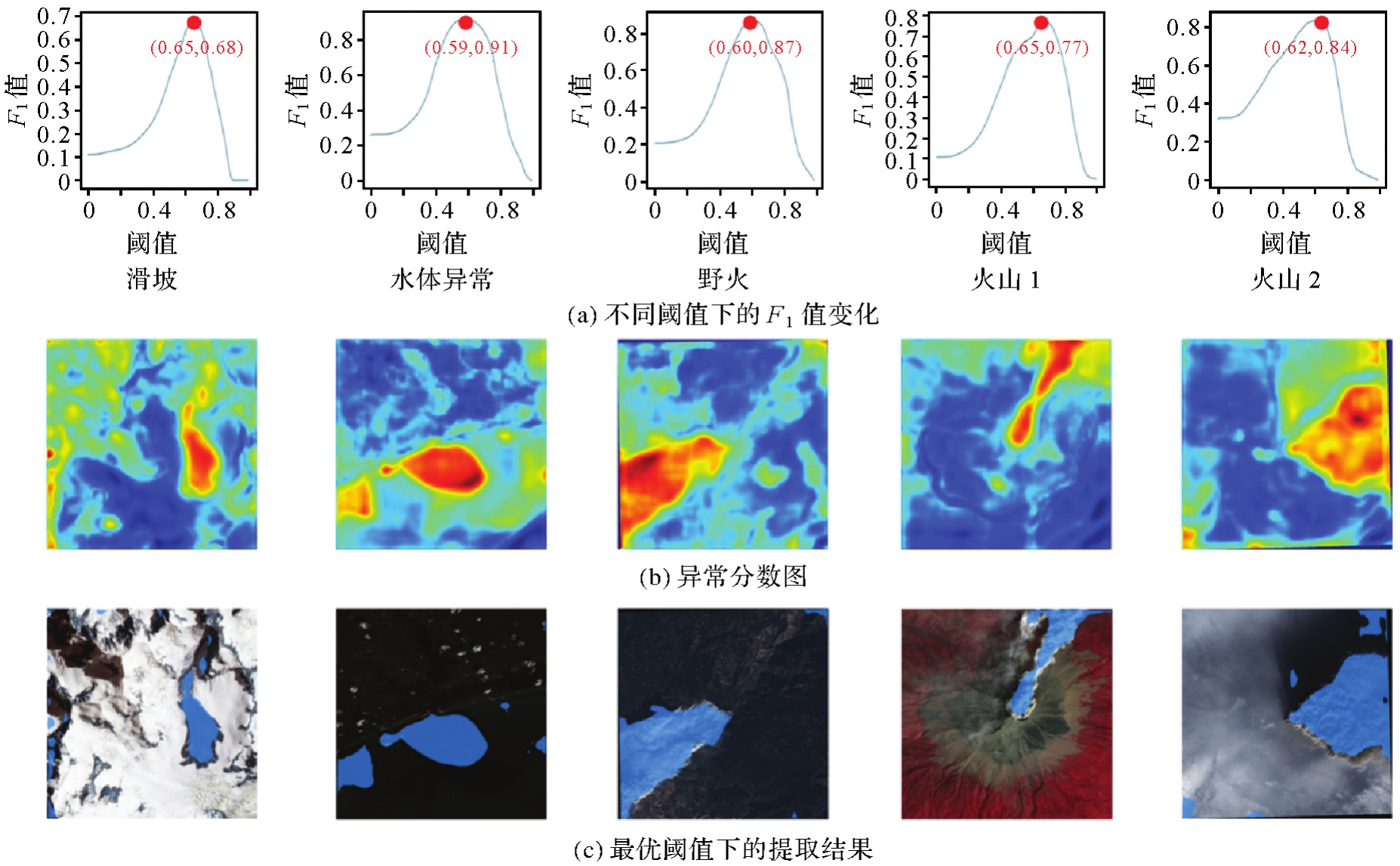
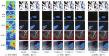
Fig. 6
Threshold sensitivity analysis of the proposed method"

| [1] | WEI Haishuo, JIA Kun, WANG Qiao, et al. Real-time remote sensing detection framework of the Earth's surface anomalies based on a priori knowledge base[J]. International Journal of Applied Earth Observation and Geoinformation, 2023, 122: 103429. |
| [2] |
Climate Change 2023: Synthesis Report. Contribution of Working Groups I, II and III to the Sixth Assessment Report of the Intergovern mental Panel on Climate Change[R]. Zurich: IPCC, 2023: 35-115. DOI: .
doi: 10.59327/IPCC/AR6-9789291691647 |
| [3] | 黄顺祥. 大气污染与防治的过去、现在及未来[J]. 科学通报, 2018, 63(10): 895-919. |
| HUANG Shunxiang. The past, present, and future of air pollution prevention and control[J]. Scientific Bulletin, 2018, 63(10): 895-919. | |
| [4] | 施斌, 张泰银. 岩土体灾变感知与应用[J]. 中国科学:技术科学, 2023, 53(10): 1639-1651. |
| SHI Bin, ZHANG Taiyin. Perception and application of rock and soil mass disasters[J]. Chinese Science: Technical Science, 2023, 53(10): 1639-1651. | |
| [5] | BEHMEL S, DAMOUR M, LUDWIG R, et al. Water quality monitoring strategies: a review and future perspectives[J]. Science of The Total Environment, 2016, 571: 1312-1329. |
| [6] | 李德仁. 从珞珈系列卫星到东方慧眼星座[J]. 武汉大学学报(信息科学版), 2023, 48(10): 1557-1565. |
| LI Deren. From the Luojia series satellites to the oriental smart eye constellation[J]. Geomatics and Information Science of Wuhan University, 2023, 48(10): 1557-1565. | |
| [7] | SHAH-HOSSEINI R, SAFARI A, HOMAYOUNI S. Natural hazard damage detection based on object-level support vector data description of optical and SAR Earth observations[J]. International Journal of Remote Sensing, 2017, 38(11): 3356-3374. |
| [8] | LI Chengfan, ZHANG Zixuan, LIU Lan, et al. A novel deep multi-instance convolutional neural network for disaster classification from high-resolution remote sensing images[J]. IEEE Journal of Selected Topics in Applied Earth Observations and Remote Sensing, 2024, 17: 2098-2114. |
| [9] | SALESKA S R, DIDAN K, HUETE A R, et al. Amazon forests green-up during 2005 drought[J]. Science, 2007, 318(5850): 612. |
| [10] | ANNIBALLE R, NOTO F, SCALIA T, et al. Earthquake damage mapping: an overall assessment of ground surveys and VHR image change detection after L'Aquila 2009 earthquake[J]. Remote Sensing of Environment, 2018, 210: 166-178. |
| [11] | SENF C, SEIDL R. Mapping the forest disturbance regimes of Europe[J]. Nature Sustainability, 2021, 4(1): 63-70. |
| [12] | CASAGLI N, INTRIERI E, TOFANI V, et al. Landslide detection, monitoring and prediction with remote-sensing techniques[J]. Nature Reviews Earth and Environment, 2023, 4(1): 51-64. |
| [13] | 李德仁, 沈欣, 龚健雅, 等. 论我国空间信息网络的构建[J]. 武汉大学学报(信息科学版), 2015, 40(6): 711-715, 766. |
| LI Deren, SHEN Xin, GONG Jianya, et al. On construction of China's space information network[J]. Geomatics and Information Science of Wuhan University, 2015, 40(6): 711-715, 766. | |
| [14] |
王桥. 地表异常遥感探测与即时诊断方法研究框架[J]. 测绘学报, 2022, 51(7): 1141-1152. DOI: .
doi: 10.11947/j.AGCS.2022.20220124 |
|
WANG Qiao. Research framework of remote sensing monitoring and real-time diagnosis of earth surface anomalies[J]. Acta Geodaetica et Cartographica Sinica, 2022, 51(7): 1141-1152. DOI: .
doi: 10.11947/j.AGCS.2022.20220124 |
|
| [15] |
李德仁, 王密, 杨芳. 新一代智能测绘遥感科学试验卫星珞珈三号01星[J]. 测绘学报, 2022, 51(6): 789-796. DOI: .
doi: 10.11947/j.AGCS.2022.20220184 |
|
LI Deren, WANG Mi, YANG Fang. A new generation of intelligent mapping and remote sensing scientific test satellite Luojia-3 01[J]. Acta Geodaetica et Cartographica Sinica, 2022, 51(6): 789-796. DOI: .
doi: 10.11947/j.AGCS.2022.20220184 |
|
| [16] |
王密, 杨芳. 智能遥感卫星与遥感影像实时服务[J]. 测绘学报, 2019, 48(12): 1586-1594. DOI: .
doi: 10.11947/j.AGCS.2019.20190454 |
|
WANG Mi, YANG Fang. Intelligent remote sensing satellite and remote sensing image real-time service[J]. Acta Geodaetica et Cartographica Sinica, 2019, 48(12): 1586-1594. DOI: .
doi: 10.11947/j.AGCS.2019.20190454 |
|
| [17] | 侯霞, 刘哲绮, 常亦迪, 等. 卫星激光通信技术发展现状与趋势分析[J]. 中国激光, 2024, 51(11): 231-244. |
| HOU Xia, LIU Zheqi, CHANG Yidi, et al. Analysis on development status and trend of space laser communication technology[J]. Chinese Journal of Lasers, 2024, 51(11): 231-244. | |
| [18] | 王行行, 霍占伟, 牟洪元, 等. 吉林一号卫星激光通信数据传输试验及应用[J]. 国际太空, 2024(2): 42-49. |
| WANG Xingxing, HUO Zhanwei, MOU Hongyuan, et al. Laser communication data transmission experiment and application of Jilin-1 satellite[J]. Space International, 2024(2): 42-49. | |
| [19] | YANG Yuanxi, LIU Li, LI Jinlong. Featured services and performance of BDS-3[J]. Science Bulletin, 2021, 66(20): 2135-2143. |
| [20] | RŮŽIČKA V, VAUGHAN A, DE MARTINI D, et al. RaVÆn: unsupervised change detection of extreme events using ML on-board satellites[J]. Scientific Reports, 2022, 12: 16939. |
| [21] | 李德仁, 沈欣. 我国天基信息实时智能服务系统发展战略研究[J]. 中国工程科学, 2020, 22(2): 138-143. |
| LI Deren, SHEN Xin. Research on the development strategy of real time and intelligent space-based information service system in China[J]. Strategic Study of CAE, 2020, 22(2): 138-143. | |
| [22] | GANDHI G M, PARTHIBAN S, THUMMALU N, et al. Ndvi: vegetation change detection using remote sensing and GIS-a case study of Vellore district[J]. Procedia Computer Science, 2015, 57: 1199-1210. |
| [23] | SU Jinya, COOMBES M, LIU Cunjia, et al. Machine learning-based crop drought mapping system by UAV remote sensing RGB imagery[J]. Unmanned Systems, 2020, 8(1): 71-83. |
| [24] | XU Yichu, ZHANG Lefei, DU Bo, et al. Hyperspectral anomaly detection based on machine learning: an overview[J]. IEEE Journal of Selected Topics in Applied Earth Observations and Remote Sensing, 2022, 15: 3351-3364. |
| [25] | WANG Wei, ZHANG Baoju, WANG Dan, et al. Anomaly detection based on probability density function with Kullback-Leibler divergence[J]. Signal Processing, 2016, 126: 12-17. |
| [26] | RŽIČKA V, VAUGHAN A, DE MARTINI D, et al. RaVÆn: unsupervised change detection of extreme events using ML on-board satellites[J]. Scientific Reports, 2022, 12: 16939. |
| [27] | XU Jianming, YAN Kai, FAN Zaiwang, et al. Toward a novel method for general on-orbit earth surface anomaly detection leveraging large vision models and lightweight priors[J]. IEEE Transactions on Geoscience and Remote Sensing, 2024, 62: 1-21. |
| [28] | GAO Bocai. NDWI: a normalized difference water index for remote sensing of vegetation liquid water from space[J]. Remote Sensing of Environment, 1996, 58(3): 257-266. |
| [29] | HE Kaiming, ZHANG Xiangyu, REN Shaoqing, et al. Deep residual learning for image recognition[C]//Proceedings of 2016 IEEE Conference on Computer Vision and Pattern Recognition. Las Vegas: IEEE, 2016: 770-778. |
| [30] | HUANG Xin, ZHU Tingting, ZHANG Liangpei, et al. A novel building change index for automatic building change detection from high-resolution remote sensing imagery[J]. Remote Sensing Letters, 2014, 5(8): 713-722. |
| [31] | MORAVEC D, KOMÁREK J, LÓPEZ-CUERVO MEDINA S, et al. Effect of atmospheric corrections on NDVI: intercomparability of Landsat 8, Sentinel-2, and UAV sensors[J]. Remote Sensing, 2021, 13(18): 3550. |
| [32] | NAGOL J R, VERMOTE E F, PRINCE S D. Effects of atmospheric variation on AVHRR NDVI data[J]. Remote Sensing of Environment, 2009, 113(2): 392-397. |
| [33] | KIRILLOV A, MINTUN E, RAVI N, et al. Segment anything[C]//Proceedings of 2023 IEEE/CVF International Conference on Computer Vision. Paris: IEEE, 2023: 3992-4003. |
| [34] | DOSOVITSKIY A, BEYER L, KOLESNIKOV A, et al. An image is worth 16x16 words: transformers for image recognition at scale[EB/OL]. [2024-10-23]. https://api.semanticscholar.org/CorpusID:225039882. |
| [35] | BAHRI Y, DYER E, KAPLAN J, et al. Explaining neural scaling laws[J]. Proceedings of the National Academy of Science, 2024, 121(27): e2311878121. |
| [36] | HE Kaiming, FAN Haoqi, WU Yuxin, et al. Momentum contrast for unsupervised visual representation learning[C]//Proceedings of 2020 IEEE/CVF Conference on Computer Vision and Pattern Recognition. Seattle: IEEE, 2020: 9726-9735. |
| [37] | SOM R K. Practical sampling techniques[M]. Boca Raton: CRC press, 1995. |
| [38] | CARVALHO JÚNIOR O A, GUIMARÃES R F, GILLESPIE A R, et al. A new approach to change vector analysis using distance and similarity measures[J]. Remote Sensing, 2011, 3(11): 2473-2493. |
| [39] | WARNER T. Hyperspherical direction cosine change vector analysis[J]. International Journal of Remote Sensing, 2005, 26(6): 1201-1215. |
| [40] | GOLDSTEIN M, DENGEL A. Histogram-based outlier score (HBOS): a fast unsupervised anomaly detection algorithm[J]. KI-2012: Poster and Demo Track, 2012, 1: 59-63. |
| [41] | ZHAO Y, NASRULLAH Z, LI Z. PyOD: a Python toolbox for scalable outlier detection[J]. Journal of Machine Learning Research, 2019, 20(96): 1-7. |
| [1] | LIU Yinnian, XUE Yongqi. Development and key technologies of spaceborne hyperspectral imaging payload [J]. Acta Geodaetica et Cartographica Sinica, 2023, 52(7): 1045-1058. |
| Viewed | ||||||
|
Full text |
|
|||||
|
Abstract |
|
|||||