

Acta Geodaetica et Cartographica Sinica ›› 2026, Vol. 55 ›› Issue (1): 90-100.doi: 10.11947/j.AGCS.2026.20250325
• Geodesy and Navigation • Previous Articles Next Articles
Qiqian SUN1( ), Shuaidong JIA1(), Zhicheng LIANG2, Xianpeng LIU1, Haoshi SONG1
Received:2025-08-13
Revised:2025-12-28
Online:2026-02-13
Published:2026-02-13
Contact:
Shuaidong JIA
E-mail:2393272126@qq.com;sky_jsd@163.com
About author:SUN Qiqian (2003—), male, postgraduate, majors in crowdsourced bathymetric data processing and modeling. E-mail: 2393272126@qq.com
Supported by:CLC Number:
Qiqian SUN, Shuaidong JIA, Zhicheng LIANG, Xianpeng LIU, Haoshi SONG. A method for constructing digital depth model of strait passage considering crowdsourced bathymetric data characteristics[J]. Acta Geodaetica et Cartographica Sinica, 2026, 55(1): 90-100.
Fig. 1
Basic steps"
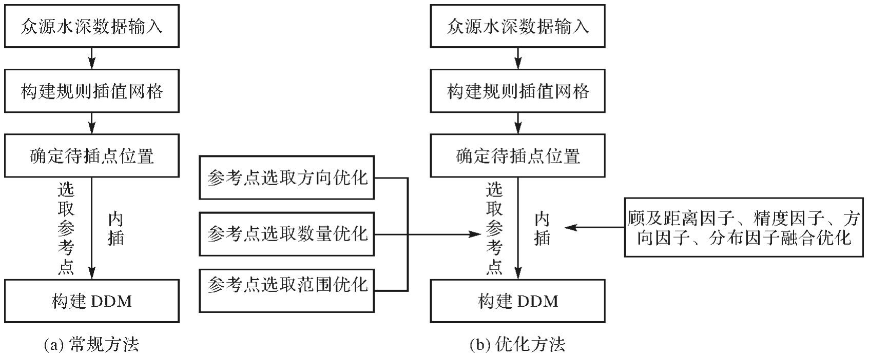
Fig. 2
Comparison of reference point selection methods"
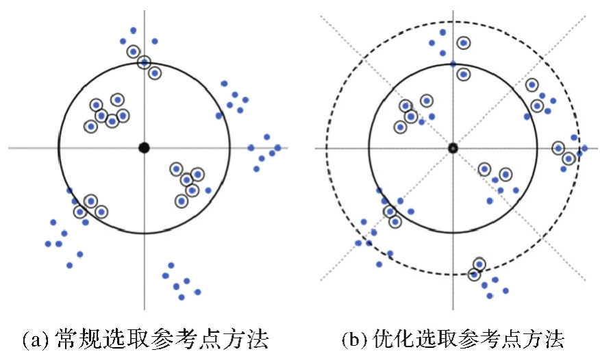
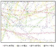
Fig. 3
Crowdsourced bathymetric data distribution"
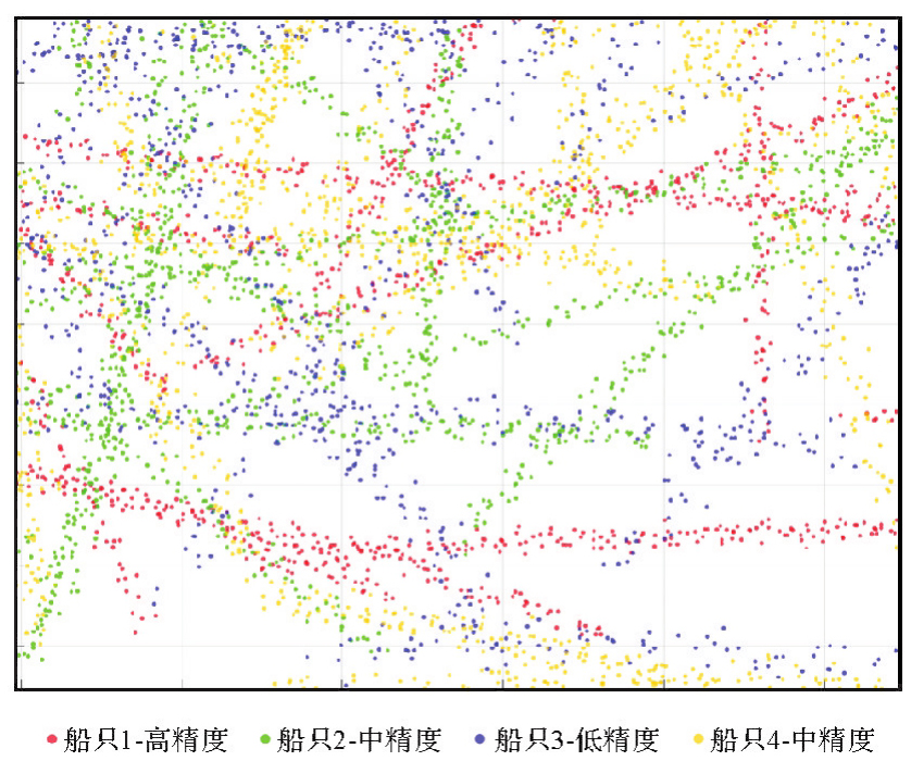
Tab. 1
Source of measurement data"
| 编号 | 测量时间 | 定位手段 | 测深手段 | 作业条件 | 精度 |
|---|---|---|---|---|---|
| 1 | 2021 | GNSS | 单波束测深 | 海况好,航速平稳,设备状态良好 | 高 |
| 2 | 2021 | GNSS | 单波束测深 | 海况较好,船舶航行状态较稳定 | 中 |
| 3 | 2020 | GNSS | 单波束测深 | 海况较差,船舶航行状态颠簸 | 低 |
| 4 | 2018 | GNSS | 单波束测深 | 海况较好,船舶航行状态较稳定 | 中 |
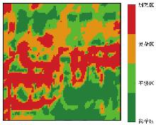
Fig. 4
Experimental sea area zoning map"

Tab. 2
Comparison of overall DDM accuracy"
| 方法 | RMSE | MAE |
|---|---|---|
| 常规IDW法 | 3.366 | 2.154 |
| 优化选取IDW法 | 3.338 | 2.110 |
| 优化内插IDW法 | 2.903 | 1.851 |
| 综合优化IDW法 | 2.829 | 1.794 |
| 克里金法 | 3.109 | 1.946 |
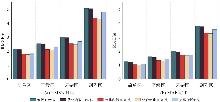
Fig. 5
Overall accuracy comparison of DDM in different regions"
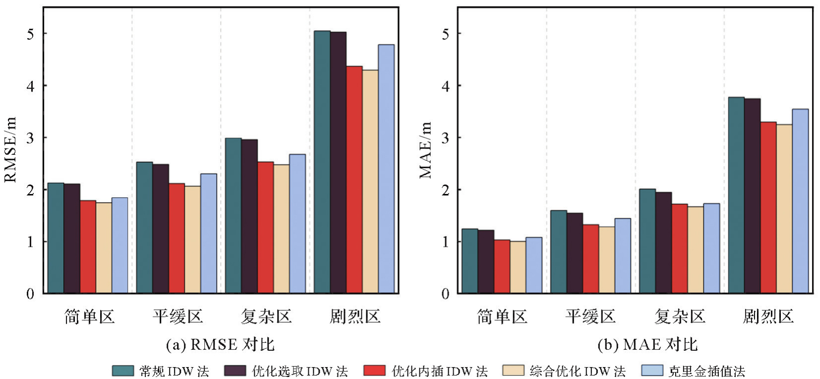
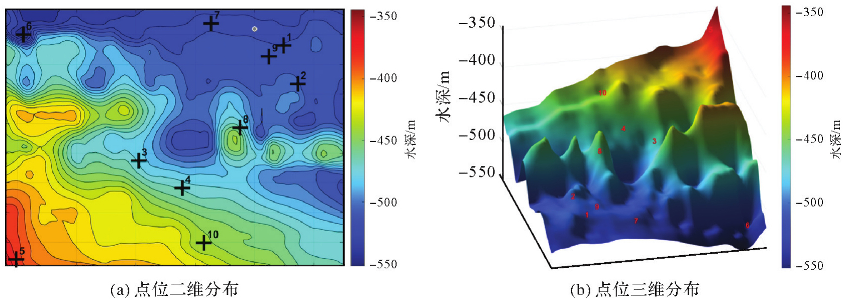
Fig. 6
Point distribution map"
Tab. 3
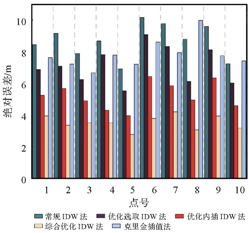
Absolute errors of 5 methods at 10 points"
| 点号 | 参考值 | 克里金 | 常规IDW | 优化选取IDW | 优化内插IDW | 综合优化IDW | |||||
|---|---|---|---|---|---|---|---|---|---|---|---|
| 内插值 | 绝对误差 | 内插值 | 绝对误差 | 内插值 | 绝对误差 | 内插值 | 绝对误差 | 内插值 | 绝对误差 | ||
| 1 | 511.17 | 503.55 | 7.62 | 502.73 | 8.44 | 518.04 | 6.87 | 516.41 | 5.24 | 507.23 | 3.94 |
| 2 | 502.57 | 495.36 | 7.21 | 493.42 | 9.15 | 509.66 | 7.09 | 508.26 | 5.69 | 499.22 | 3.35 |
| 3 | 473.53 | 466.87 | 6.66 | 465.64 | 7.89 | 479.76 | 6.23 | 468.64 | 4.89 | 477.03 | 3.50 |
| 4 | 465.83 | 458.05 | 7.78 | 474.51 | 8.68 | 458.02 | 7.81 | 461.53 | 4.30 | 469.33 | 3.50 |
| 5 | 376.01 | 368.81 | 7.20 | 369.11 | 6.90 | 370.48 | 5.53 | 379.96 | 3.95 | 373.24 | 2.77 |
| 6 | 544.56 | 535.96 | 8.60 | 534.40 | 10.16 | 553.64 | 9.08 | 551.00 | 6.44 | 540.78 | 3.78 |
| 7 | 515.99 | 508.05 | 7.94 | 506.22 | 9.77 | 507.66 | 8.33 | 510.15 | 5.84 | 520.19 | 4.20 |
| 8 | 465.46 | 455.49 | 9.97 | 456.67 | 8.79 | 459.34 | 6.12 | 470.41 | 4.95 | 468.52 | 3.06 |
| 9 | 508.48 | 500.74 | 7.74 | 518.07 | 9.59 | 516.59 | 8.11 | 502.15 | 6.33 | 512.41 | 3.93 |
| 10 | 439.20 | 431.78 | 7.42 | 446.43 | 7.23 | 445.23 | 6.03 | 434.61 | 4.59 | 442.37 | 3.17 |
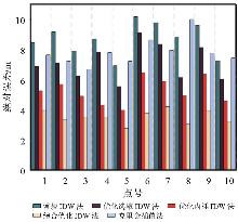
Fig. 7
Comparison of absolute errors for 5 methods"
Tab. 4
Overall accuracy comparison of DDM with different weight combinations"
| 权重因子组合 | RMSE | MAE |
|---|---|---|
| 单一距离因子 | 2.968 | 1.875 |
| 距离因子+分布因子 | 2.830 | 1.792 |
| 距离因子+分布因子+精度因子 | 2.903 | 1.851 |
| 距离因子+方位因子+分布因子 | 2.873 | 1.817 |
| 综合优化IDW法 | 2.829 | 1.794 |
| [1] | International Hydrographic Organization. IHO Hydrographic dictionary/multilingual reference for IHO publications: S-32[S]. Monaco: International Hydrographic Organization, 2019. |
| [2] | 《海洋测绘词典》编辑委员会. 海洋测绘词典[M]. 北京: 测绘出版社, 2022. |
| Editorial Board of Marine Surveying and Mapping Dictionary. Marine surveying and mapping dictionary[M]. Beijing: Surveying and Mapping Press, 2022. | |
| [3] | 阮晓光, 占赵杰, 闫兆进, 等. 基于全球测深数据的中国海岸线周边海域数字水深模型融合[J]. 海洋学报, 2024, 46(7): 16-28. |
| RUAN Xiaoguang, ZHAN Zhaojie, YAN Zhaojin, et al. Digital bathymetric model fusion of offshore waters around China's coastline based on global bathymetry data[J]. Haiyang Xuebao, 2024, 46(7): 16-28. | |
| [4] | HUANG Daozheng, WANG Shun, LOUGHNEY S, et al. Evolutionary game model of strategic maritime transport passages: a case of the strait of Hormuz[J]. Journal of Marine Science and Engineering, 2022, 10(3): 346. |
| [5] | 陶怡轩, 刘成彦, 王召民. 水文水深数据修正的普里兹湾数字水深模型[J]. 大气科学学报, 2021, 44(1): 128-139. |
| TAO Yixuan, LIU Chengyan, WANG Zhaomin. An improved digital bathymetric model for Prydz Bay by hydrography observations[J]. Transactions of Atmospheric Sciences, 2021, 44(1): 128-139. | |
| [6] | AMANTE C J, EAKINS B W. Accuracy of interpolated bathymetry in digital elevation models[J]. Journal of Coastal Research, 2016, 76: 123-133. |
| [7] | MALEIKA W. Inverse distance weighting method optimization in the process of digital terrain model creation based on data collected from a multibeam echosounder[J]. Applied Geomatics, 2020, 12(4): 397-407. |
| [8] | LIU Zhiqiang, XU Bo, CHENG Bo, et al. Retracted interpolation parameters in inverse distance-weighted interpolation algorithm on DEM interpolation error[J]. Journal of Sensors, 2021: 3535195. |
| [9] | 王可伟, 高利华, 江锋. 基于改进反距离加权算法的海底DEM建模方法[J]. 海洋测绘, 2021, 41(1): 61-64. |
| WANG Kewei, GAO Lihua, JIANG Feng. A method of seabed DEM modeling based on the improved inverse distance weighted interpolation algorithm[J]. Hydrographic Surveying and Charting, 2021, 41(1): 61-64. | |
| [10] | 张洁, 段平. 地形因子对反距离加权插值方法(IDW)最优距离指数的影响分析[J]. 地理科学, 2023, 43(7): 1281-1290. |
| ZHANG Jie, DUAN Ping. Influence of terrain factors on optimal order distance of inverse distance weighted (IDW)[J]. Scientia Geographica Sinica, 2023, 43(7): 1281-1290. | |
| [11] | 王怀计, 祝俊慧, 胡莹, 等. 顾及特征水深点距离重分配的反距离加权插值算法[J]. 海洋通报, 2022, 41(1): 9-18. |
| WANG Huaiji, ZHU Junhui, HU Ying, et al. Inverse distance weighted interpolation with the consideration of distance redistribution of characteristic depth points[J]. Marine Science Bulletin, 2022, 41(1): 9-18. | |
| [12] | SONG Shangfa, WANG Siyu, ZHOU Fangpeng. Digital terrain model based on fractal compensated distance inverse weight interpolation[C]//Proceedings of 2025 International Conference on Intelligent Computing and Signal Processing (ICSP). Xi'an: IEEE, 2025: 1040-1043. |
| [13] | ZHANG Tao, XU Xiaosu, XU Shengbao. Method of establishing an underwater digital elevation terrain based on Kriging interpolation[J]. Measurement, 2015, 63: 287-298. |
| [14] | 董箭, 季宏超, 刘国辉, 等. 临界滚动球半径优化的非航海TIN-DDM自动综合算法[J]. 武汉大学学报(信息科学版), 2025, 50(5): 996-1005. |
| DONG Jian, JI Hongchao, LIU Guohui, et al. Non-navigational TIN-DDM automatic generalization algorithm for optimizing critical rolling ball radius[J]. Geomatics and Information Science of Wuhan University, 2025, 50(5): 996-1005. | |
| [15] | 贾俊涛, 翟京生, 孟婵媛, 等. 基于海量多波束数据的海底地形模型的构建与可视化[J]. 测绘科学技术学报, 2008, 25(4): 255-259. |
| JIA Juntao, ZHAI Jingsheng, MENG Chanyuan, et al. Construction and visualization of submarine DEM based on large number of multibeam data[J]. Journal of Geomatics Science and Technology, 2008, 25(4): 255-259. | |
| [16] | 刘杰, 张旗, 王荻. 基于全球海域多波束测深数据构建DBM与Web服务[J]. 海洋测绘, 2024, 44(2): 14-17. |
| LIU Jie, ZHANG Qi, WANG Di. Building DBM and web services based on global multibeam bathymetry data[J]. Hydrographic Surveying and Charting, 2024, 44(2): 14-17. | |
| [17] | 樊妙, 孙毅, 邢喆, 等. 基于多源水深数据融合的海底高精度地形重建[J]. 海洋学报, 2017, 39(1): 130-137. |
| FAN Miao, SUN Yi, XING Zhe, et al. Bathymetry fusion techniques for high-resolution digital bathymetric modeling[J]. Haiyang Xuebao, 2017, 39(1): 130-137. | |
| [18] | AMOROSO P P, AGUILAR F J, PARENTE C, et al. Statistical assessment of some interpolation methods for building grid format digital bathymetric models[J]. Remote Sensing, 2023, 15(8): 2072. |
| [19] | MA Huadong, ZHOU Haiying, WEN Yubo, et al. Accuracy analysis of interpolation method for abrupt change of seabed water depth[C]//Proceedings of 2022 International Conference on Geology, Mapping and Remote Sensing (ICGMRS). Zhoushan: IEEE, 2022: 818-821. |
| [20] | ŁACKA M, ŁUBCZONEK J. Methodology for creating a digital bathymetric model using neural networks for combined hydroacoustic and photogrammetric data in shallow water areas[J]. Sensors, 2024, 24(1): 175. |
| [21] | 王振, 张锡亭, 王建华. 基于BP神经网络的高分辨率海底地形跨层生成模型[J]. 应用科技, 2024, 51(1): 143-150, 176. |
| WANG Zhen, ZHANG Xiting, WANG Jianhua. High-resolution submarine topography cross-layer generation model via BP neural network[J]. Applied Science and Technology, 2024, 51(1): 143-150, 176. | |
| [22] | ZHANG Liwen, WEN Jiabao, HUO Ziqiang, et al. From land to ocean: bathymetric terrain reconstruction via conditional generative adversarial network[J]. Earth Science Informatics, 2024, 17(5): 4361-4375. |
| [23] | SRIVASTAVA S P. Davis strait: structures, origin and evolution[M]//Structure and development of the Greenland-Scotland Ridge. Boston: Springer, 1983: 159-189. |
| [24] | AYDOGDU Y V. A comparison of maritime risk perception and accident statistics in the Istanbul straight[J]. Journal of Navigation, 2014, 67(1): 129-144. |
| [25] | PAYNE P. Crowdsourced bathymetry and its use to support resurvey activity in the North Sea region[J]. The International Hydrographic Review, 2023, 29(2): 248-253. |
| [26] | 邬金, 王平, 王久, 等. 众包水深测量的关键技术研究与分析[J]. 海洋测绘, 2020, 40(2): 36-40. |
| WU Jin, WANG Ping, WANG Jiu, et al. Research and analysis of key methods for crowdsourced bathymetry[J]. Hydrographic Surveying and Charting, 2020, 40(2): 36-40. | |
| [27] | International Hydrographic Organization. Guidance on crowdsourced bathysmetry(3.0.0)[R]. Monaco: IHO, 2024. |
| [28] | RADIĆ T, PAVIĆ I, MIŠKOVIĆ J. Comparison of hydrographic survey data with crowdsourced bathymetry data[J]. Naše More, 2023, 70(2): 115-125. |
| [29] | WANG Dejun, WANG Yanxia, LIANG Shan, et al. A N-order interpolated variance estimator algorithm for fusion of inland waterway crowd-sourced bathymetry data[C]//Proceedings of 2022 International Conference on Intelligent Transportation Engineering (ICITE). Beijing: IEEE, 2023: 66-71. |
| [30] | WAMAI M, TAN Qulin. Evaluating the impact of different point cloud sampling techniques on digital elevation model accuracy-a case study of Kituro, Kenya[J]. Earth Science Informatics, 2024, 17(6): 5149-5169. |
| [31] | ZHANG Hairong, LU Lijiang, LIU Yanhua, et al. Spatial sampling strategies for the effect of interpolation accuracy[J]. ISPRS International Journal of Geo-Information, 2015, 4(4): 2742-2768. |
| [32] | ZHANG Jinming. Optimization of interpolation parameters based on statistical experiment[J]. Open Geosciences, 2022, 14(1): 880-905. |
| [33] | 兰燕, 王明华, 刘珊红, 等. 逐点内插法建立DEM的研究[J]. 测绘科学, 2009, 34(1): 214-216. |
| LAN Yan, WANG Minghua, LIU Shanhong, et al. Study on building DEM based on point-by-point interpolation algorithm[J]. Science of Surveying and Mapping, 2009, 34(1): 214-216. | |
| [34] | LI Jin, HEAP A D. Spatial interpolation methods applied in the environmental sciences: a review[J]. Environmental Modelling & Software, 2014, 53: 173-189. |
| [35] | CRESSIE N A C. Statistics for spatial data[M]. New York: Wiley, 2015. |
| [36] | 汤国安, 刘学军, 闾国年. 数字高程模型及地学分析的原理与方法[M]. 北京: 科学出版社, 2005. |
| TANG Guoan, LIU Xuejun, LÜ Guonian. Principles and methods of digital elevation model and geoscience analysis[M]. Beijing: Science Press, 2005. | |
| [37] | 王家耀. 空间信息系统原理[M]. 北京: 科学出版社, 2001. |
| WANG Jiayao. Principle of spatial information system[M]. Beijing: Science Press, 2001. | |
| [38] | BATOOL A, AHMAD S, WASEEM A, et al. Evaluating variogram models and Kriging approaches for analyzing spatial trends in precipitation simulations from global climate models[J]. Acta Geophysica, 2025, 73(4): 3677-3697. |
| [39] | 张一凡, 张璐璐, 徐加宝. 地质统计学变异函数贝叶斯模型选择方法与比较[J]. 地质科技通报, 2025, 44(2): 38-47. |
| ZHANG Yifan, ZHANG Lulu, XU Jiabao. Bayesian methods for geostatistical variogram model selection and comparative study[J]. Bulletin of Geological Science and Technology, 2025, 44(2): 38-47. | |
| [40] | 徐武平, 邱峰, 徐爱萍. 空间数据插值的自动化方法研究[J]. 武汉大学学报(信息科学版), 2016, 41(4): 498-502. |
| XU Wuping, QIU Feng, XU Aiping. Automatic method of Kriging interpolation of spatial data[J]. Geomatics and Information Science of Wuhan University, 2016, 41(4): 498-502. | |
| [41] | LIU Longdong, WANG Baoli, LIN Ying, et al. Anisotropic spatial structure Kriging interpolation method based on statistical characteristic parameters of random media[J]. IEEE Transactions on Geoscience and Remote Sensing, 2025, 63: 4506017. |
| [42] | PAVIC I, MIŁKOVIC J, KASUM J, et al. Analysis of crowdsourced bathymetry concept and it's potential implications on safety of navigation[J]. TransNav, the International Journal on Marine Navigation and Safety of Sea Transportation, 2020, 14(3): 681-686. |
| [1] | Qingyun YAN, Zixuan GUO, Yuanjin PAN, Yan JIA, Shuanggen JIN. Quantitative driving factors and zoning patterns of GNSS-R land surface reflectivity spatial heterogeneity [J]. Acta Geodaetica et Cartographica Sinica, 2026, 55(2): 315-327. |
| [2] | Min DENG, Chong PENG, Kaiqi CHEN. A predictability measurement methodology for spatial panel data considering geo-spatial effects [J]. Acta Geodaetica et Cartographica Sinica, 2025, 54(7): 1305-1317. |
| [3] | Yating LIU, Chuanfa CHEN. Landslide susceptibility evaluation method considering spatial heterogeneity and feature selection [J]. Acta Geodaetica et Cartographica Sinica, 2024, 53(7): 1417-1428. |
| [4] | PI Xinyu, ZENG Yongnian, WANG Pancheng. Spatially enhanced spatio-temporal fusion model for heterogeneity regions [J]. Acta Geodaetica et Cartographica Sinica, 2023, 52(10): 1714-1723. |
| [5] | PENG Rencan, DONG Jian, JIA Shuaidong, TANG Lulu, WANG Fang. Research progress and prospect of digital depth model constructing technology [J]. Acta Geodaetica et Cartographica Sinica, 2022, 51(7): 1575-1587. |
| [6] | DONG Jian, PENG Rencan, ZHANG Lihua, LIU Guohui, ZHU Qiang. Multi-scale Representation of Digital Depth Model Based on Double Direction Rolling Ball Transform according to the Reality Principle [J]. Acta Geodaetica et Cartographica Sinica, 2017, 46(6): 789-801. |
| [7] | CAI Jiannan, LIU Qiliang, XU Feng, DENG Min, HE Zhanjun, TANG Jianbo. An Adaptive Method for Mining Hierarchical Spatial Co-location Patterns [J]. Acta Geodaetica et Cartographica Sinica, 2016, 45(4): 475-485. |
| [8] | . A Method for Constructing an Adaptive Grid Digital Depth Model Based on Mean Vertical Uncertainty of Area [J]. Acta Geodaetica et Cartographica Sinica, 2012, 41(3): 0-416. |
| [9] | . A Method for Interpolating Digital Depth Model Considering Uncertainty [J]. Acta Geodaetica et Cartographica Sinica, 2011, 40(3): 359-365. |
| Viewed | ||||||
|
Full text |
|
|||||
|
Abstract |
|
|||||