

Acta Geodaetica et Cartographica Sinica ›› 2024, Vol. 53 ›› Issue (6): 1013-1024.doi: 10.11947/j.AGCS.2024.20240024
• Smart Surveying and Mapping • Previous Articles Next Articles
Wanzeng LIU1,2,3( ), Xinpeng WANG2,3(), Tingting ZHAO2,3, Xi ZHAI2,3, Ran LI2,3, Xiuli ZHU2,3, Zhihao JIANG2,3, Yunlu PENG2,3, Ye ZHANG2,3
Received:2024-01-15
Published:2024-07-22
Contact:
Xinpeng WANG
E-mail:luwnzg@163.com;wangxinpeng0512@163.com
About author:LIU Wanzeng (1970—), male, PhD, professor level senior engineer, majors in GIS spatial relationship, emergency mapping and knowledge service. E-mail: luwnzg@163.com
Supported by:CLC Number:
Wanzeng LIU, Xinpeng WANG, Tingting ZHAO, Xi ZHAI, Ran LI, Xiuli ZHU, Zhihao JIANG, Yunlu PENG, Ye ZHANG. Scale evaluation method for fragmented terrain vector data[J]. Acta Geodaetica et Cartographica Sinica, 2024, 53(6): 1013-1024.
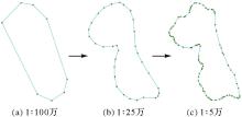
Fig.1
Comparison of the number of nodes on contour lines at different scales"
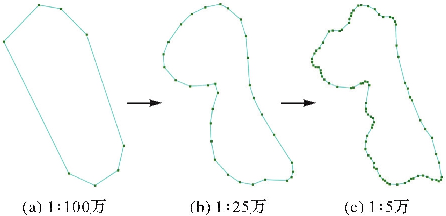
Fig.2
Node density distribution of contour lines at different scales"

Fig.3
Scale judgment of terrain vector data coupled with knowledge and algorithm"
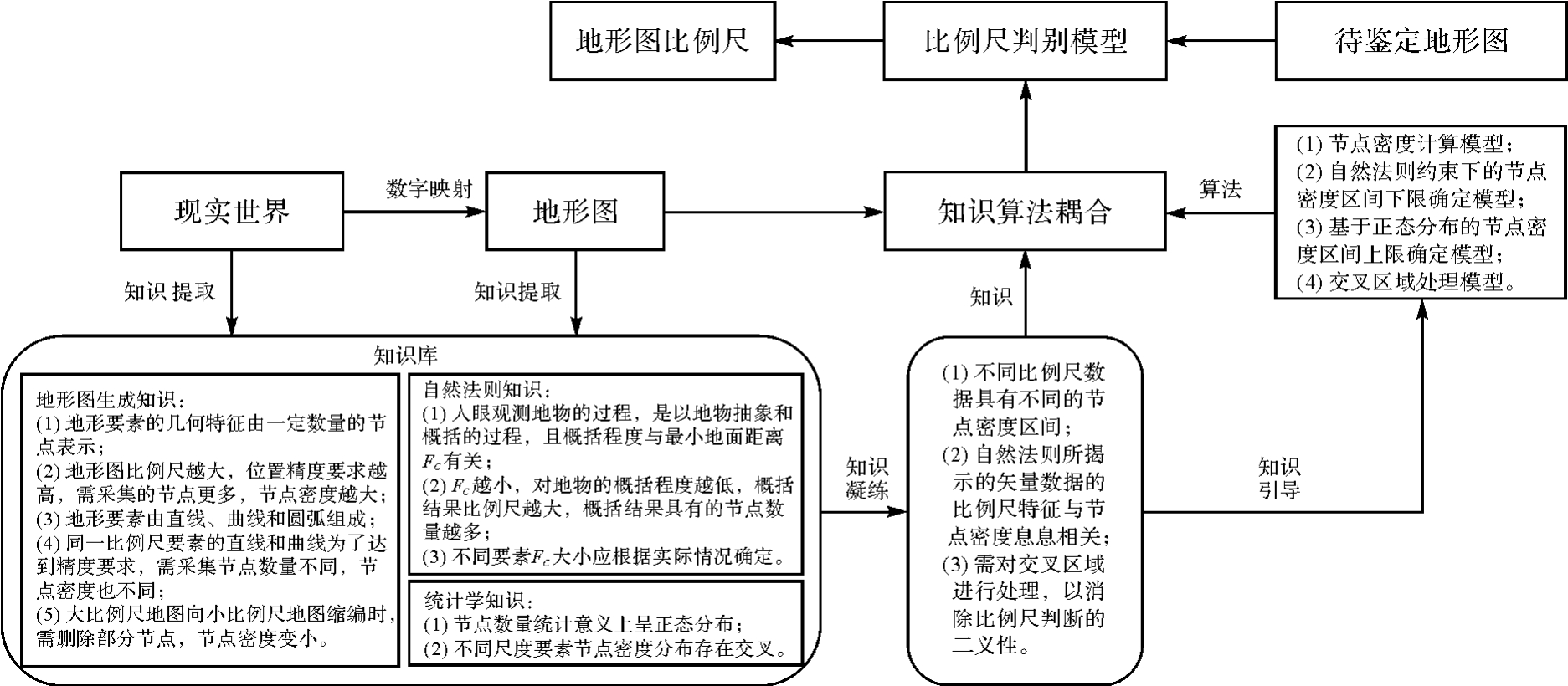
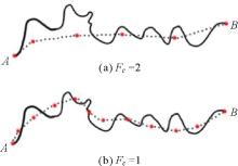
Fig.4
Summary results of ground features with Fc=2 and Fc=1"
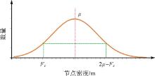
Fig.5
The upper limit determining principle of node density range"
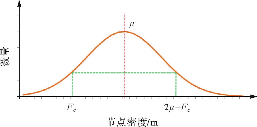
Fig.6
Node density for each line segment of a 1∶50 000 water system map"
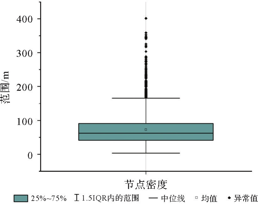
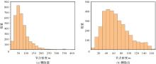
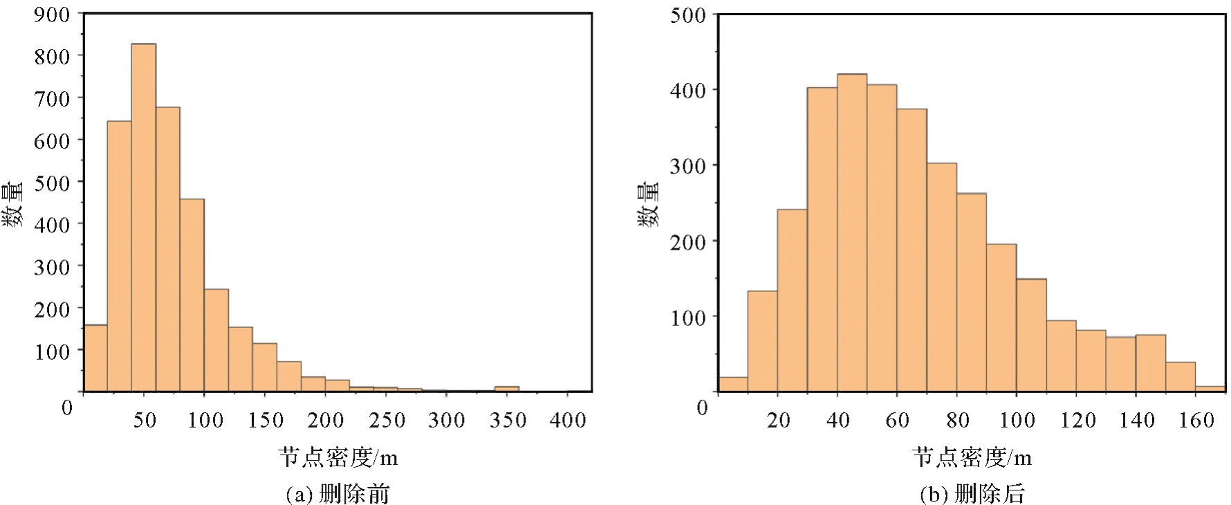
Fig.7
Density distribution of nodes in various line segments of a 1∶50 000 water system map before and after outliers deletion"
Tab.1
Normal distribution test results of original 1∶250 000 water system node density data"
| 样本数量 | 均值/m | 标准差/m | 偏度 | 峰度 | S-W检验P值 | K-S检验P值 | 在5%水平下的结论 |
|---|---|---|---|---|---|---|---|
| 668 | 203.93 | 75.13 | 0.89 | 0.56 | 5.55×10¹⁵ | 1.255×10¹⁶ | 排除正态性 |
Tab.2
Normal distribution test results of 1∶250 000 water system node density index after logarithmic conversion"
| 样本数量 | 均值 | 标准差 | 偏度 | 峰度 | S-W检验P值 | K-S检验P值 | 在5%水平下的结论 |
|---|---|---|---|---|---|---|---|
| 668 | 2.28 | 0.16 | 0.01 | -0.27 | 0.09 | 0.38 | 不能排除正态性 |
Fig.8
Node density and node density index distribution of 1∶250 000 water system sample data before and after logarithmic conversion"
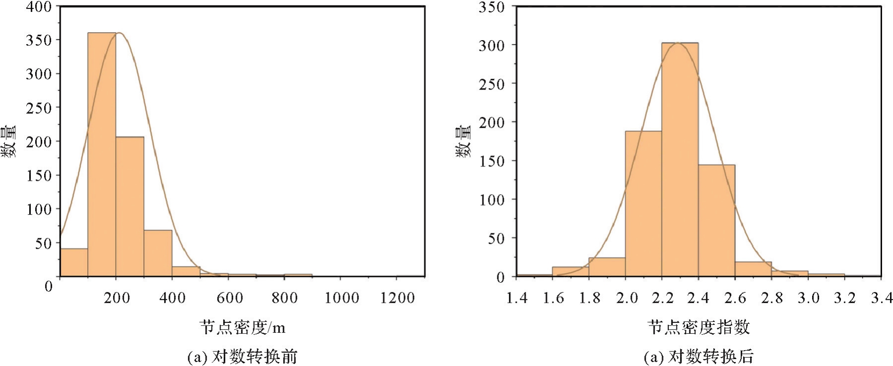
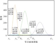
Fig.9
The cross region processing"
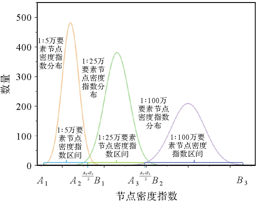
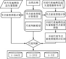
Fig.10
The flowchart of scale determination"
Fig.11
Normal distribution of node density index of contour lines with different scales"

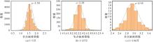
Fig.12
Normal distribution of node density index of water system with different scales"

Tab.3
and μ' value statistics of contour lines with different scales"
| 比例尺 |  | μ' | 2μ'- |
|---|---|---|---|
| 1∶5万 | 1 | 1.42 | 1.84 |
| 1∶25万 | 1.60 | 2.08 | 2.56 |
| 1∶100万 | 2.28 | 2.77 | 3.26 |
Tab.4
and μ' value statistics of water lines with different scales"
| 比例尺 |  | μ' | 2μ'- |
|---|---|---|---|
| 1∶5万 | 1.18 | 1.58 | 1.98 |
| 1∶25万 | 1.78 | 2.28 | 2.78 |
| 1∶100万 | 2.45 | 2.92 | 3.39 |
Tab.5
Node density index intervals of contour lines and water system elements at different scales under the constraints of natural laws"
| 比例尺 | 类别 | |
|---|---|---|
| 等高线 | 水系 | |
| 1∶100万 | (2.42,3.26] | (2.62,3.39] |
| 1∶25万 | [1.72,2.42] | [1.88,2.62] |
| 1∶5万 | [1,1.72) | [1.18,1.88) |
Tab.6
The accuracy of the scale of 1∶1 000 000 terrain vector features"
| 要素类型 | 鉴定图幅数 | 正确图幅数 | 错误图幅数 | 正确率/(%) |
|---|---|---|---|---|
| 水系 | 108 | 100 | 8 | 92.59 |
| 等高线 | 91 | 87 | 4 | 95.60 |
Tab.7
The accuracy of the scale of 1∶250 000 terrain vector features"
| 要素类型 | 鉴定图幅数 | 正确图幅数 | 错误图幅数 | 正确率/(%) |
|---|---|---|---|---|
| 水系 | 740 | 687 | 53 | 92.84 |
| 等高线 | 787 | 749 | 38 | 95.17 |
Tab.8
The accuracy of the scale of 1∶50 000 terrain vector features"
| 要素类型 | 鉴定图幅数 | 正确图幅数 | 错误图幅数 | 正确率/(%) |
|---|---|---|---|---|
| 水系 | 920 | 864 | 56 | 93.91 |
| 等高线 | 994 | 896 | 88 | 90.14 |
Tab.9
Statistics on the accuracy of the terrain vector features scale determination"
| 要素比例尺 | 鉴定图幅数 | 正确图幅数 | 错误图幅数 | 正确率/(%) |
|---|---|---|---|---|
| 1∶100万 | 199 | 187 | 12 | 93.97 |
| 1∶25万 | 1527 | 1436 | 91 | 94.04 |
| 1∶5万 | 1914 | 1770 | 144 | 92.47 |
| 整体 | 3640 | 3393 | 247 | 93.21 |
| [1] | 刘万增, 彭震中. 我国测绘地理信息成果保密政策分析及对策[J]. 地理信息世界, 2016, 23(4):54-58. |
| LIU Wanzeng, PENG Zhenzhong. Analysis and countermeasures for secrecy policy on mapping geographic information results of China[J]. Geomatics World, 2016, 23(4):54-58. | |
| [2] | 易树柏. 论地理信息安全在国家安全中的作用[J]. 理论界, 2016 (8):40-48. |
| YI Shubai. On the role of geoinformation security to national security strategy[J]. Theory Horizon, 2016 (8):40-48. | |
| [3] | 高惠君. 城市规划空间数据的多尺度处理与表达研究[D]. 北京: 中国矿业大学(北京), 2012. |
| GAO Huijun. Research on multi-scale handling and representation of urban planning spatial data[D]. Beijing: China University of Mining & Technology, Beijing, 2012. | |
| [4] | 刘万增, 陈军, 赵勇, 等. 地理信息保密安全评估的基本问题与对策[J]. 时空信息学报, 2023, 30(4):474-481. |
| LIU Wanzeng, CHEN Jun, ZHAO Yong, et al. Fundamental issues and countermeasures of geographic information security assessment[J]. Journal of Spatio-Temporal Information, 2023, 30(4):474-481. | |
| [5] | 王家耀, 成毅. 空间数据的多尺度特征与自动综合[J]. 海洋测绘, 2004, 24(4):1-3. |
| WANG Jiayao, CHENG Yi. The multiple character of spatial data and automated generalization[J]. Hydrographic Surveying and Charting, 2004, 24(4):1-3. | |
| [6] | 孙庆先, 李茂堂, 路京选, 等. 地理空间数据的尺度问题及其研究进展[J]. 地理与地理信息科学, 2007, 23(4):53-56, 80. |
| SUN Qingxian, LI Maotang, LU Jingxuan, et al. Scale issue and its research progress of geospatial data[J]. Geography and Geo-Information Science, 2007, 23(4):53-56, 80. | |
| [7] | 陈俊杰. 不同尺度下地理实体的一体化组织与表达方法研究[D]. 杭州: 浙江大学, 2011. |
| CHEN Junjie. Study on the integrative organization and representation method for geographical entity in different scales[D]. Hangzhou: Zhejiang University, 2011. | |
| [8] | 刘凯, 秦耀辰. 论地理信息的尺度特性[J]. 地理与地理信息科学, 2010, 26(2):1-5. |
| LIU Kai, QIN Yaochen. On scale characteristics of geographic information[J]. Geography and Geo-Information Science, 2010, 26(2):1-5. | |
| [9] | 周卫, 朱长青, 吴卫东. 地理信息的安全特征综述[J]. 测绘通报, 2015 (10):122-125. |
| ZHOU Wei, ZHU Changqing, WU Weidong. Review of the security features of geographic information[J]. Bulletin of Surveying and Mapping, 2015 (10):122-125. | |
| [10] | 朱长青, 任娜, 徐鼎捷. 地理信息安全技术研究进展与展望[J]. 测绘学报, 2022, 51(6):1017-1028. DOI:10.11947/j.AGCS.2022.20220172. |
| ZHU Changqing, REN Na, XU Dingjie. Geo-information security technology: progress and prospects[J]. Acta Geodaetica et Cartographica Sinica, 2022, 51(6):1017-1028. DOI:10.11947/j.AGCS.2022.20220172. | |
| [11] | 乔朝飞, 贾宗仁, 徐坤, 等. 从国外情况看我国地理信息保密政策调整[J]. 测绘与空间地理信息, 2020, 43(12):1-4. |
| QIAO Chaofei, JIA Zongren, XU Kun, et al. Adjustment of geospatial information confidentiality policy in China from the perspective of foreign situation[J]. Geomatics & Spatial Information Technology, 2020, 43(12):1-4. | |
| [12] | 任加新, 刘万增, 陈军, 等. 知识引导的碎片化栅格地形图比例尺智能识别[J]. 测绘学报, 2024, 53(1):146-157. DOI:10.11947/j.AGCS.2024.20230005. |
| REN Jiaxin, LIU Wanzeng, CHEN Jun, et al. Knowledge-guided intelligent recognition of the scale for fragmented raster topographic maps[J]. Acta Geodaetica et Cartographica Sinica, 2024, 53(1):146-157. DOI:10.11947/j.AGCS.2024.20230005. | |
| [13] | CHEN Wanzhi. Internet geographic information security supervision platform architecture research[J]. International Journal of Online and Biomedical Engineering (IJOE), 2013, 9(S2):13. |
| [14] | 王迪, 钱海忠, 赵钰哲. 综述与展望:地理空间数据的管理、多尺度变换与表达[J]. 地球信息科学学报, 2022, 24(12):2265-2281. |
| WANG Di, QIAN Haizhong, ZHAO Yuzhe. Review and prospect: management, multi-scale transformation and representation of geospatial data[J]. Journal of Geo-Information Science, 2022, 24(12):2265-2281. | |
| [15] | 艾廷华, 张翔. 地理信息科学中尺度概念的诠释与表达[J]. 测绘学报, 2022, 51(7):1640-1652. DOI:10.11947/j.AGCS.2022.20220143. |
| AI Tinghua, ZHANG Xiang. An interpretation and representation of scale concept in geo-information sciences[J]. Acta Geodaetica et Cartographica Sinica, 2022, 51(7):1640-1652. DOI:10.11947/j.AGCS.2022.20220143. | |
| [16] | 吴冰娇. 基于几何与语义相似性的多尺度道路网数据匹配方法研究[D]. 兰州: 兰州交通大学, 2022. |
| WU Bingjiao. Research on multi-scale road network data matching method based on geometric and semantic similarity[D]. Lanzhou: Lanzhou Jiatong University, 2022. | |
| [17] | LI Zhilin, OPENSHAW S. A natural principle for the objective generalization of digital maps[J]. Cartography and Geographic Information Systems, 1993, 20(1):19-29. |
| [18] | LI Zhilin. Transformation of spatial representation in scale dimension: a new paradigm for digital generalization of spatial data[J]. International Archives of Photogrammetry and Remote Sensing, 1996, XXXI(B3):453-458. |
| [19] | 钟其洋, 郭庆胜, 王勇, 等. 基于空间粒度的矢量空间数据比例尺估算方法[J]. 测绘通报, 2022 (8):117-122. |
| ZHONG Qiyang, GUO Qingsheng, WANG Yong, et al. The method for estimating the scale of vector spatial data based on spatial granularity[J]. Bulletin of Surveying and Mapping, 2022 (8):117-122. | |
| [20] | 樊玉鑫, 郭庆胜, 王勇, 等. 参考样本库的线状道路空间数据比例尺估算[J]. 测绘科学, 2022, 47(7):208-215. |
| FAN Yuxin, GUO Qingsheng, WANG Yong, et al. Scale estimation for linear road spatial data on sample database[J]. Science of Surveying and Mapping, 2022, 47(7):208-215. | |
| [21] | 刘鹏程, 李精忠, 艾廷华. 数字地图要素的细节层次一致性评价模型研究[J]. 中国矿业大学学报, 2019, 48(2):437-444. |
| LIU Pengcheng, LI Jingzhong, AI Tinghua. Evaluation model of level of detail consistency of the features on digital maps[J]. Journal of China University of Mining & Technology, 2019, 48(2):437-444. | |
| [22] | 刘万增, 陆辰妮, 霍亮, 等. 最优信息熵约束的居民地点状要素选取方法[J]. 武汉大学学报(信息科学版), 2021, 46(8):1178-1185. |
| LIU Wanzeng, LU Chenni, HUO Liang, et al. Selection method of residential point features constrained by optimal information entropy[J]. Geomatics and Information Science of Wuhan University, 2021, 46(8):1178-1185. | |
| [23] | 付青松. GIS矢栅数据结构及数据组织管理研究[J]. 测绘与空间地理信息, 2010, 33(6):64-66, 72. |
| FU Qingsong. The research of GIS raster data structure and data organization and management[J]. Geomatics & Spatial Information Technology, 2010, 33(6):64-66, 72. | |
| [24] | 刘万增, 陈军, 金舒平, 等. 空间曲线长度计算与精度评价模型[J]. 测绘通报, 2013 (2):38-40, 58. |
| LIU Wanzeng, CHEN Jun, JIN Shuping, et al. Space curve length calculation and accuracy assessment model[J]. Bulletin of Surveying and Mapping, 2013 (2):38-40, 58. | |
| [25] | DOUGLAS D H, PEUCKER T K. Algorithms for the reduction of the number of points required to represent a digitized line or its caricature[J]. Classics in Cartography: Reflections on Influential Articles from Cartographica, 2011:15-28. |
| [26] | 杨得志, 王杰臣, 闾国年. 矢量数据压缩的Douglas-Peucker算法的实现与改进[J]. 测绘通报, 2002 (7):18-19, 22. |
| YANG Dezhi, WANG Jiechen, LÜ Guonian. Study of realization method and improvement of Douglas-Peucher algorithm of vector data compressing[J]. Bulletin of Surveying and Mapping, 2002 (7):18-19, 22. | |
| [27] | 李霖, 应申. 空间尺度基础性问题研究[J]. 武汉大学学报(信息科学版), 2005, 30(3):199-203. |
| LI Lin, YING Shen. Fundamental problem on spatial scale[J]. Geomatics and Information Science of Wuhan University, 2005, 30(3):199-203. | |
| [28] | 李志林, 刘启亮, 唐建波. 尺度驱动的空间聚类理论[J]. 测绘学报, 2017, 46(10):1534-1548. DOI:10.11947/j.AGCS.2017.20170275. |
| LI Zhilin, LIU Qiliang, TANG Jianbo. Towards a scale-driven theory for spatial clustering[J]. Acta Geodaetica et Cartographica Sinica, 2017, 46(10):1534-1548. DOI:10.11947/j.AGCS.2017.20170275. | |
| [29] | LI Zhilin, OPENSHAW S. Algorithms for automated line generalization based on a natural principle of objective generalization[J]. International Journal of Geographical Information Systems, 1992, 6(5):373-389. |
| [1] | Yue QIU, Fang WU, Renjian ZHAI, Haizhong QIAN, Zhekun HUANG, Bo LI. An entity-level conformal spatial alignment model for multi-source building matching optimization [J]. Acta Geodaetica et Cartographica Sinica, 2025, 54(12): 2262-2275. |
| [2] | LI Hao, YUE Peng, JIANG Liangcun, ZHANG Mingda, LIANG Zheheng. Blockchain technology for vector geographic provenance information organization and verification [J]. Acta Geodaetica et Cartographica Sinica, 2021, 50(6): 823-832. |
| [3] | XIE Peng, YANG Chuncheng, XIONG Shun, HE Liesong, ZHOU Xiaodong. Design and optimization of spatial vector data storage model based on HBase [J]. Acta Geodaetica et Cartographica Sinica, 2020, 49(10): 1365-1373. |
| [4] | TONG Deyu, ZHU Changqing, REN Na. Watermarking Algorithm Applying to Small Amount of Vector Geographical Data [J]. Acta Geodaetica et Cartographica Sinica, 2018, 47(11): 1518-1525. |
| [5] | SUN Qun. Research on the Progress of Multi-sources Geospatial Vector Data Fusion [J]. Acta Geodaetica et Cartographica Sinica, 2017, 46(10): 1627-1636. |
| [6] | LI Zhilin, LIU Qiliang, TANG Jianbo. Towards a Scale-driven Theory for Spatial Clustering [J]. Acta Geodaetica et Cartographica Sinica, 2017, 46(10): 1534-1548. |
| [7] | . Research on Registration Method between Vector Data and Image Data based on Shape Feature [J]. Acta Geodaetica et Cartographica Sinica, 2014, 43(8): 879-879. |
| [8] | MA Xiaolong LI Chengming ZHAO Zhanjie. Three-dimensional Road Intersection Automatic Inspection and Robotization Modeling Based on OSG [J]. Acta Geodaetica et Cartographica Sinica, 2014, 43(10): 1083-1091. |
| [9] | 1,. Robust Watermarking Algorithm for Geometrical Transform for Vector Geo-spatial Data Based on Invariant Function [J]. Acta Geodaetica et Cartographica Sinica, 2011, 40(2): 256-261. |
| [10] |
.
Multi-scale Evaluation Method for Uncertainty of Remote Sensing Classification Based on Hybrid Entropy Model
[J]. Acta Geodaetica et Cartographica Sinica, 2009, 38(1): 0-11.
|
| Viewed | ||||||
|
Full text |
|
|||||
|
Abstract |
|
|||||