

Acta Geodaetica et Cartographica Sinica ›› 2024, Vol. 53 ›› Issue (7): 1278-1287.doi: 10.11947/j.AGCS.2024.20230079
• Geodesy and Navigation • Previous Articles Next Articles
Rongwei ZHU1,2( ), Yinhu ZHAN2(), Guangyun LI2
Received:2023-04-07
Published:2024-08-12
Contact:
Yinhu ZHAN
E-mail:3475217943@qq.com;oscardad@163.com
About author:ZHU Rongwei (2001—), male, assistant engineer, majors in astronomical surveying and navigation. E-mail: 3475217943@qq.com
Supported by:CLC Number:
Rongwei ZHU, Yinhu ZHAN, Guangyun LI. Algorithm for ground positioning by simultaneously imaging stars and low orbit satellites[J]. Acta Geodaetica et Cartographica Sinica, 2024, 53(7): 1278-1287.
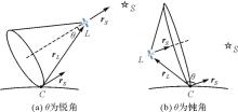
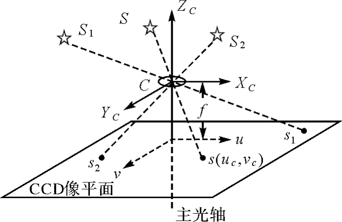
Fig.1
Position cone"

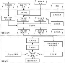
Fig.2
Flowchart of the proposed algorithm"
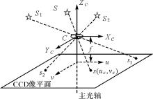
Camera imaging model"
Tab.1
Simulation conditions"
| 项目 | 内容指标 |
|---|---|
| 试验平台 | Legion Y7000P 2020H型笔记本电脑 |
| 测站坐标 | 113.092 8°E,34.534 4°N,高程460 m |
| 观测时段 | UTC 2023-04-19 20:00:00-20:50:00 |
| 仿真步长/min | 1 |
| 视场角/(°) | 120 |
| 极限星等 | 6.5 |
| 星间角距测量精度/(″) | 30 |
| 大气折射改正精度(60°)/(″) | 5 |
| 时间精度/ms | 1 |
| 卫星轨道精度/m | 10 |
| 低轨星座 | Starlink |
| 地影模型 | 柱形地影 |
| 恒星星表 | 依巴谷星表 |
Fig.4
LEO satellite visibility"
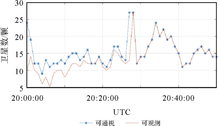
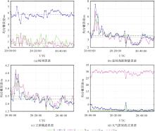
Fig.5
Impact of major error sources on positioning accuracy"
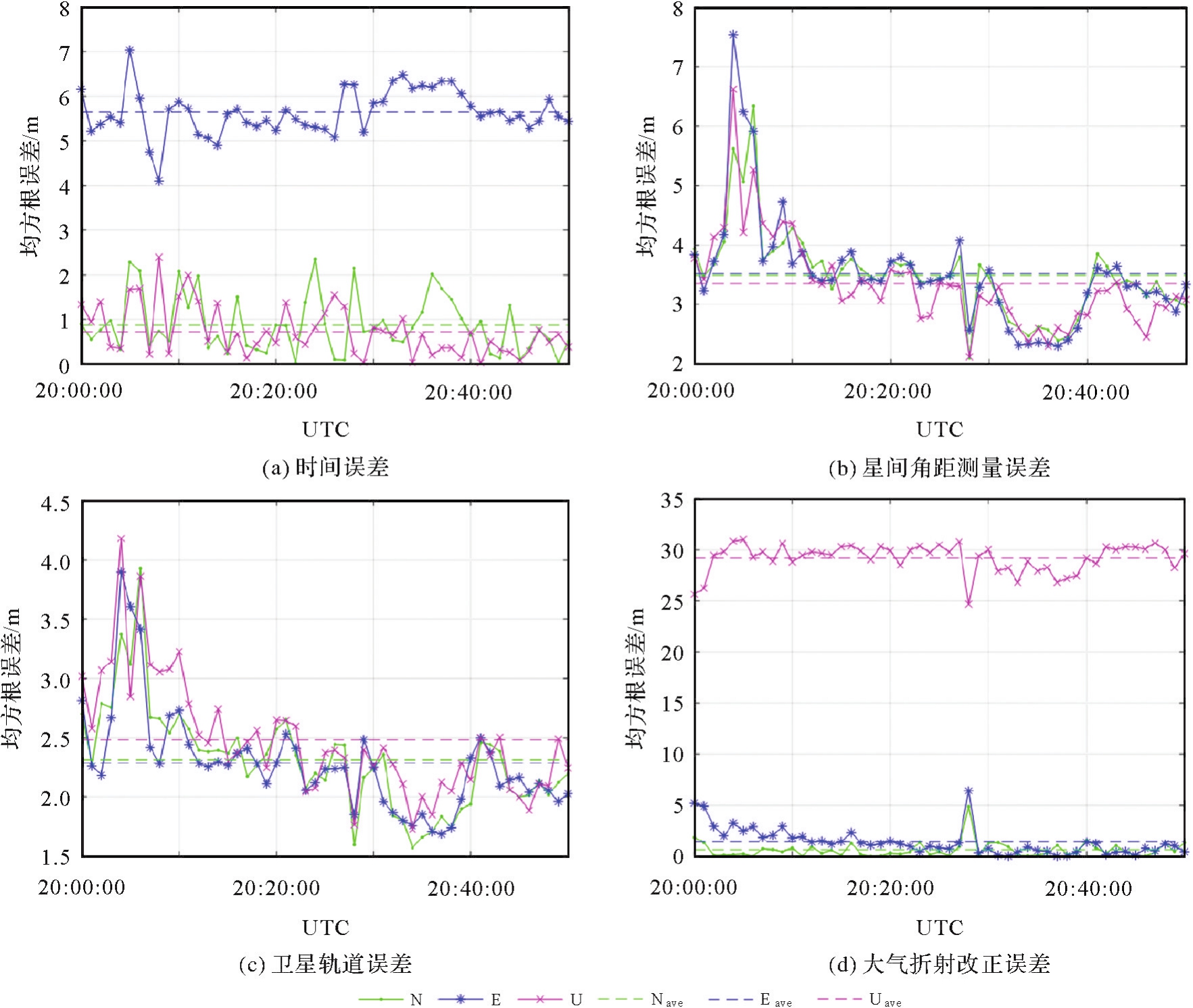
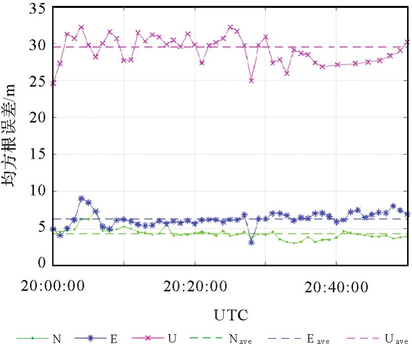
Fig.6
Positioning accuracy plotted against time"
| [1] | 杨元喜. 综合PNT体系及其关键技术[J]. 测绘学报, 2016, 45(5):505-510. DOI: 10.11947/j.AGCS.2016.20160127. |
| YANG Yuanxi. Concepts of comprehensive PNT and related key technologies[J]. Acta Geodaetica et Cartographica Sinica, 2016, 45(5):505-510. DOI: 10.11947/j.AGCS.2016.20160127. | |
| [2] | 张小红, 马福建. 低轨导航增强GNSS发展综述[J]. 测绘学报, 2019, 48(9):1073-1087. DOI: 10.11947/j.AGCS.2019.20190176. |
| ZHANG Xiaohong, MA Fujian. Review of the development of LEO navigation-augmented GNSS[J]. Acta Geodaetica et Cartographica Sinica, 2019, 48(9):1073-1087. DOI: 10.11947/j.AGCS.2019.20190176. | |
| [3] | 王巍, 邢朝洋, 冯文帅. 自主导航技术发展现状与趋势[J]. 航空学报, 2021, 42(11):525049. |
| WANG Wei, XING Chaoyang, FENG Wenshuai. State of the art and perspectives of autonomous navigation technology[J]. Acta Aeronautica et Astronautica Sinica, 2021, 42(11):525049. | |
| [4] | 张超, 詹银虎, 王若璞, 等. 光学天文大地测量技术发展评述[J]. 测绘科学技术学报, 2021, 38(4):331-336, 342. |
| ZHANG Chao, ZHAN Yinhu, WANG Ruopu, et al. Review of the development of optical astro-geodetic technology[J]. Journal of Geomatics Science and Technology, 2021, 38(4):331-336, 342. | |
| [5] | WANG Y M, BECKER C, MADER G, et al. The geoid slope validation survey 2014 and GRAV-D airborne gravity enhanced geoid comparison results in Iowa[J]. Journal of Geodesy, 2017, 91(10):1261-1276. |
| [6] | ZHAN Yinhu, CHEN Shaojie, ZHANG Xu. Adaptive celestial positioning for the stationary Mars rover based on a self-calibration model for the star sensor[J]. Journal of Navigation, 2022, 75(1):160-175. |
| [7] | 陈张雷, 李崇辉, 郑勇, 等. 天文定位中几何精度衰减因子最小值分析[J]. 测绘学报, 2019, 48(7):879-888. DOI: 10.11947/j.AGCS.2019.20180479. |
| CHEN Zhanglei, LI Chonghui, ZHENG Yong, et al. The minimum analysis of geometric dilution of precision in celestial positioning[J]. Acta Geodaetica et Cartographica Sinica, 2019, 48(7):879-888. DOI: 10.11947/j.AGCS.2019.20180479. | |
| [8] | SCHACK P, HIRT C, HAUK M, et al. A high-precision digital astrogeodetic traverse in an area of steep geoid gradients close to the coast of Perth, Western Australia [J]. Journal of Geodesy, 2018, 92(10):1143-1153. |
| [9] | 詹银虎, 郑勇, 张超, 等. 一种亮星识别算法及其在天文定向中的应用[J]. 测绘学报, 2015, 44(3):257-263. DOI: 10.11947/j.AGCS.2015.20130557. |
| ZHAN Yinhu, ZHENG Yong, ZHANG Chao, et al. Bright-star recognition algorithm and its application in astronomical azimuth determination[J]. Acta Geodaetica et Cartographica Sinica, 2015, 44(3):257-263. DOI: 10.11947/j.AGCS.2015.20130557. | |
| [10] | 郭金运, 宋来勇, 常晓涛, 等. 数字天顶摄影仪确定垂线偏差及其精度分析[J]. 武汉大学学报(信息科学版), 2011, 36(9):1085-1088. |
| GUO Jinyun, SONG Laiyong, CHANG Xiaotao, et al. Vertical deflection measure with digital zenith camera and accuracy analysis [J]. Geomatics and Information Science of Wuhan University, 2011, 36(9):1085-1088. | |
| [11] | 田立丽, 郭金运, 韩延本, 等. 我国的数字化天顶望远镜样机[J]. 科学通报, 2014, 59(12):1094-1099. |
| TIAN Lili, GUO Jinyun, HAN Yanben, et al. Prototype of digital zenith telescope in China[J]. Chinese Science Bulletin, 2014, 59(12):1094-1099. | |
| [12] | 张新帅, 周召发. 航天器姿态算法在地面天文定位中的应用研究[J]. 测绘科学, 2015, 40(5):139-143. |
| ZHANG Xinshuai, ZHOU Zhaofa. Application of attitude determination algorithms of spacecraft in celestial positioning on Earth[J]. Science of Surveying and Mapping, 2015, 40(5):139-143. | |
| [13] | 詹银虎, 郑勇, 骆亚波, 等. 无需初值及迭代的天文导航新算法[J]. 测绘科学技术学报, 2015, 32(5):445-449, 454. |
| ZHAN Yinhu, ZHENG Yong, LUO Yabo, et al. Novel celestial navigation algorithm without initial values and iterative calculations[J]. Journal of Geomatics Science and Technology, 2015, 32(5):445-449, 454. | |
| [14] | 李崇辉. 基于鱼眼相机的舰船天文导航技术研究[D]. 郑州: 信息工程大学, 2013. |
| LI Chonghui. Research on marine celestial navigation based on fisheye camera[D]. Zhengzhou: Information Engineering University, 2013. | |
| [15] | 唐君, 徐轩彬. 星敏感器技术舰船导航应用建模与实验验证[J]. 国外电子测量技术, 2019, 38(7):126-130. |
| TANG Jun, XU Xuanbin. Star sensor modeling and experimental test for ships navigation[J]. Foreign Electronic Measurement Technology, 2019, 38(7):126-130. | |
| [16] | 宋菲菲. 基于方位角的舰船天文定位算法研究[D]. 天津: 天津大学, 2018. |
| SONG Feifei. Research on ship astronomical positioning algorithm based on azimuth angle[D]. Tianjin: Tianjin University, 2018. | |
| [17] | 吴伟仁, 王大轶, 宁晓琳. 深空探测器自主导航原理与技术[M]. 北京: 中国宇航出版社出版, 2011. |
| WU Weiren, WANG Dayi, NING Xiaolin. Autonomous navigation principle of deep space probe [M]. Beijing: China Aerospace Publishing House, 2011. | |
| [18] | 魏二虎, 刘经南, 李征航, 等. 天文与深空导航学[M]. 武汉: 武汉大学出版社, 2018. |
| WEI Erhu, LIU Jingnan, LI Zhenghang, et al. Celestial and deep space navigation[M]. Wuhan: Wuhan University Press, 2018. | |
| [19] | 张雨露, 范磊, 刘江梅, 等. 商业低轨通信星座纳入国家综合PNT体系的可行性分析[J]. 导航定位学报, 2022, 10(2):26-36. |
| ZHANG Yulu, FAN Lei, LIU Jiangmei, et al. Feasibility analysis of commercial broadband LEO constellation incorporated into the national comprehensive PNT system[J]. Journal of Navigation and Positioning, 2022, 10(2):26-36. | |
| [20] | 田润, 崔志颖, 张爽娜, 等. 基于低轨通信星座的导航增强技术发展概述[J]. 导航定位与授时, 2021, 8(1):66-81. |
| TIAN Run, CUI Zhiying, ZHANG Shuangna, et al. Overview of navigation augmentation technology based on LEO[J]. Navigation Positioning and Timing, 2021, 8(1):66-81. | |
| [21] | 吴巍. 天地一体化信息网络发展综述[J]. 天地一体化信息网络, 2020, 1(1):1-16. |
| WU Wei. Survey on the development of space-integrated-ground information network[J]. Space-Integrated-Ground Information Networks, 2020, 1(1):1-16. | |
| [22] | 邵瑞, 宋叶志, 陈赟, 等. 海基单站短弧光学跟踪GEO精密定轨[J]. 兵器装备工程学报, 2022, 43(5):274-280. |
| SHAO Rui, SONG Yezhi, CHEN Yun, et al. Geostationary orbit determination by short optical observation arc of single sea-based station[J]. Journal of Ordnance Equipment Engineering, 2022, 43(5):274-280. | |
| [23] | 刘思语, 黄勇, 毛银盾, 等. 基于光学测角数据的风云四号同步轨道卫星精密定轨[J]. 中国空间科学技术, 2021, 41(6):54-62. |
| LIU Siyu, HUANG Yong, MAO Yindun, et al. Precise orbit determination of FY-4 synchronous orbit satellite based on optical angle measurement data[J]. Chinese Space Science and Technology, 2021, 41(6):54-62. | |
| [24] | 原玉磊, 郑勇, 杜兰. 星点中心高精度质心定位算法[J]. 测绘科学技术学报, 2012, 29(2):122-126. |
| YUAN Yulei, ZHENG Yong, DU Lan. High-accuracy centroid algorithm of star points[J]. Journal of Geomatics Science and Technology, 2012, 29(2):122-126. | |
| [25] | 陆正亮, 张翔, 刘洋, 等. 基于SGP4模型与多普勒频移的改进定轨方法[J]. 系统工程与电子技术, 2016, 38(6):1360-1366. |
| LU Zhengliang, ZHANG Xiang, LIU Yang, et al. Improved orbit determination based on SGP4 model and Doppler shifts[J]. Systems Engineering and Electronics, 2016, 38(6):1360-1366. | |
| [26] | 陈少杰. 鱼眼星图定位中的气象因素改正研究[D]. 郑州: 信息工程大学, 2018. |
| CHEN Shaojie. Research on atmospheric refraction in fish-eye star-map positioning[D]. Zhengzhou: Information Engineering University, 2018. | |
| [27] | 李海, 王若璞, 陈勇, 等. 图像全站仪星点质心快速提取方法研究[J]. 测绘科学技术学报, 2019, 36(5):482-486. |
| LI Hai, WANG Ruopu, CHEN Yong, et al. Fast star centroid extraction method for image total station[J]. Journal of Geomatics Science and Technology, 2019, 36(5):482-486. | |
| [28] | 刘卓然. 基于星载接收机的低轨卫星定轨及星历拟合研究[D]. 西安: 长安大学, 2021. |
| LIU Zhuoran. Research on orbit determination and ephemeris fitting of LEO satellites based on spaceborne receiver[D]. Xi'an: Chang'an University, 2021. | |
| [29] | 薛文, 胡敏, 阮永井, 等. 基于TLE的Starlink星座第一阶段部署情况分析[J]. 中国空间科学技术, 2022, 42(5):24-33. |
| XUE Wen, HU Min, RUAN Yongjing, et al. Analysis of the first stage deployment of Starlink constellation based on TLE[J]. Chinese Space Science and Technology, 2022, 42(5):24-33. |
| [1] | ZHANG Yuxuan, LONG Sichun, LAI Xiangen, KUANG Lijun, SU Ruipeng, LU Shide, ZHANG Liya, ZHOU Jian, LUO Dong, LIAO Mengguang. Monitoring method of equivalent horizontal displacement of foundation pit surrounding pile based on inverse finite element [J]. Acta Geodaetica et Cartographica Sinica, 2024, 53(1): 126-136. |
| [2] | ZHAN Yinhu, ZHANG Chao, LI Feizhan, LUO Yabo, MI Kefeng, ZHANG Xu, ZHANG Zhifeng. Astro-geodetic vertical deflection measurement and accuracy analysis based on image total station [J]. Acta Geodaetica et Cartographica Sinica, 2023, 52(2): 175-182. |
| [3] | CHEN Zhanglei, LI Chonghui, ZHENG Yong, CHEN Bing, HE Donghan. The minimum analysis of geometric dilution of precision in celestial positioning [J]. Acta Geodaetica et Cartographica Sinica, 2019, 48(7): 879-888. |
| [4] | FANG Yanan, XIN Jingmin, ZENG Guang, WANG Jiasong, LI Jie. BeiDou Satellites Multi-GNSS Precise Orbit Determination with Ambiguity Fixed [J]. Acta Geodaetica et Cartographica Sinica, 2018, 47(3): 341-347. |
| [5] | ZHU Ningning. Simulation Analysis of Cylindrical Panoramic Image Mosaic [J]. Acta Geodaetica et Cartographica Sinica, 2017, 46(4): 487-497. |
| [6] | LIU Weiping, HAO Jinming, TIAN Yingguo, YU Heli, ZHANG Kang. Solution Method and Precision Analysis of Double-difference Dynamic Precise Orbit Determination of BeiDou Navigation Satellite System [J]. Acta Geodaetica et Cartographica Sinica, 2016, 45(2): 131-139. |
| [7] | TIAN Yingguo, HAO Jinming. Swarm Satellite Antenna Phase Center Correction and Its Influence on the Precision Orbit Determination [J]. Acta Geodaetica et Cartographica Sinica, 2016, 45(12): 1406-1412. |
| [8] | XIAO Yugang, JIANG Weiping, CHEN Hua, YUAN Peng, XI Ruijie. Research and Realization of Deformation Monitoring Algorithm with Millimeter Level Precision Based on BeiDou Navigation Satellite System [J]. Acta Geodaetica et Cartographica Sinica, 2016, 45(1): 16-21. |
| [9] | ZHU Yongxing, FENG Laiping, JIA Xiaolin, ZHANG Qinghua, RUAN Rengui. The PPP Precision Analysis Based on BDS Regional Navigation System [J]. Acta Geodaetica et Cartographica Sinica, 2015, 44(4): 377-383. |
| Viewed | ||||||
|
Full text |
|
|||||
|
Abstract |
|
|||||