

Acta Geodaetica et Cartographica Sinica ›› 2024, Vol. 53 ›› Issue (10): 1853-1862.doi: 10.11947/j.AGCS.2024.20240152.
• Review • Next Articles
Renzhong GUO1,2,3,4,( ), Yebin CHEN1,2(), Zhigang ZHAO1,2, Ding MA1,2, Biao HE1,2, Weixi WANG1,2, Wuyang HONG1,2, Minmin LI4
Received:2024-04-15
Online:2024-11-26
Published:2024-11-26
Contact:
Yebin CHEN
E-mail:guorz@szu.edu.cn;chenyebin@szu.edu.cn
About author:GUO Renzhong (1956—), male, professor, academician of Chinese Academy of Engineering, majors in cartography, 3D cadastre, land resources management and smart city. E-mail: guorz@szu.edu.cn
Supported by:CLC Number:
Renzhong GUO, Yebin CHEN, Zhigang ZHAO, Ding MA, Biao HE, Weixi WANG, Wuyang HONG, Minmin LI. The transformation of the scientific concept of GIS: from Map-based GIS to Space-oriented GIS[J]. Acta Geodaetica et Cartographica Sinica, 2024, 53(10): 1853-1862.
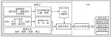
Fig.1
Methodology foundation of GIS"
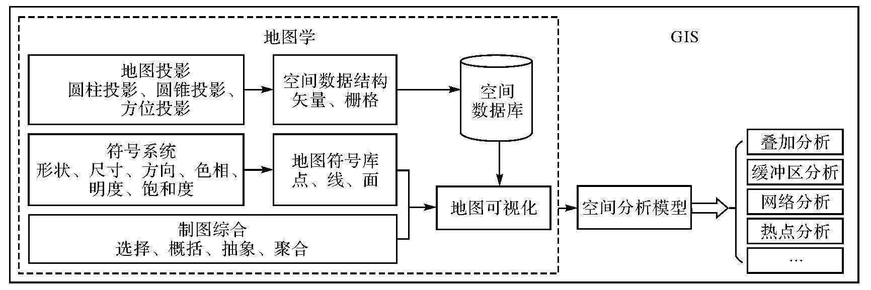
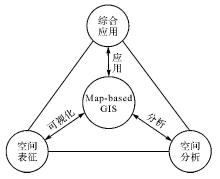
Fig.2
Challenges faced by Map-based GIS"
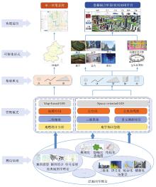
Fig.3
Scientific concept transformation model of GIS"
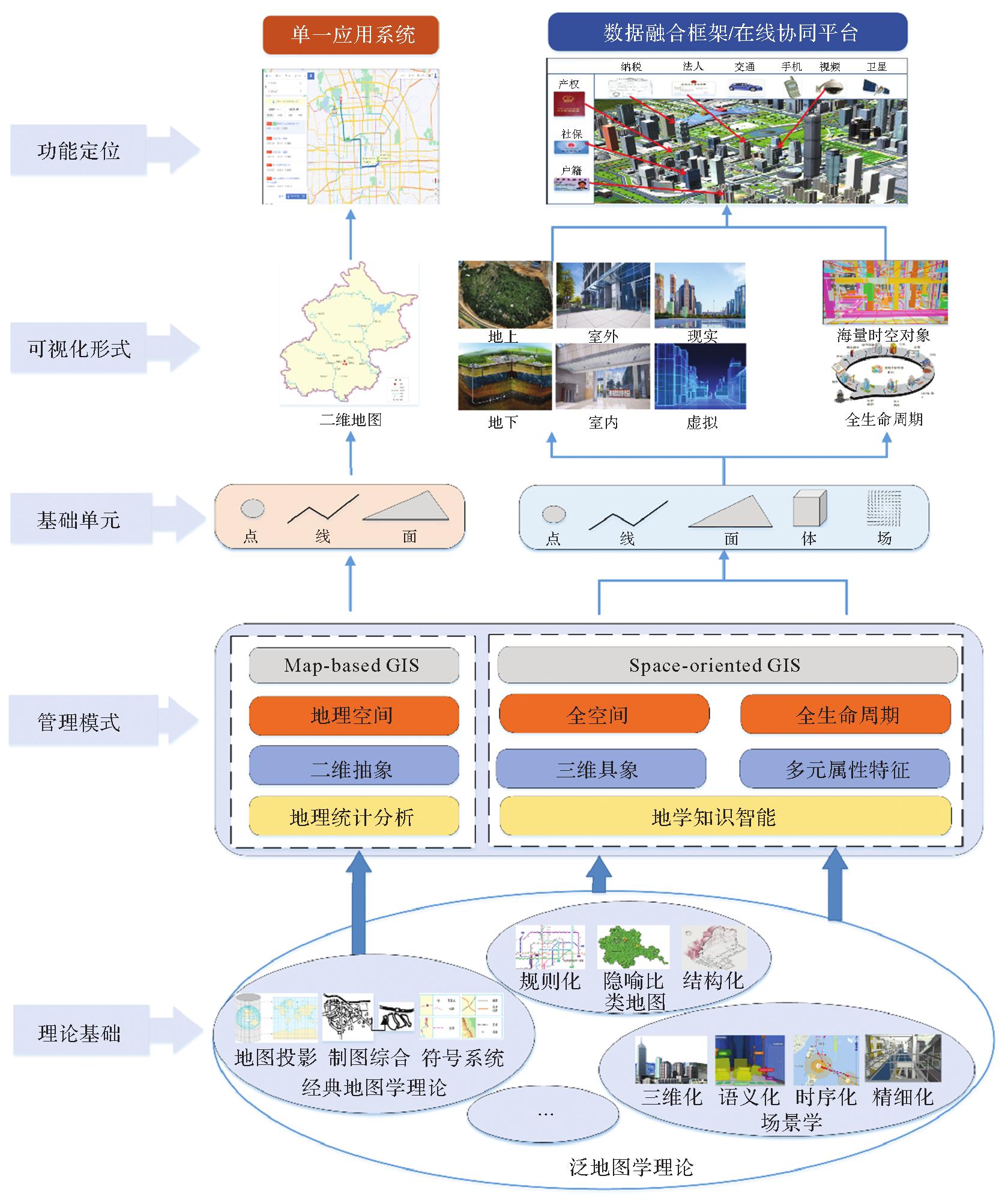

Fig.4
GIS management mode transformation model"
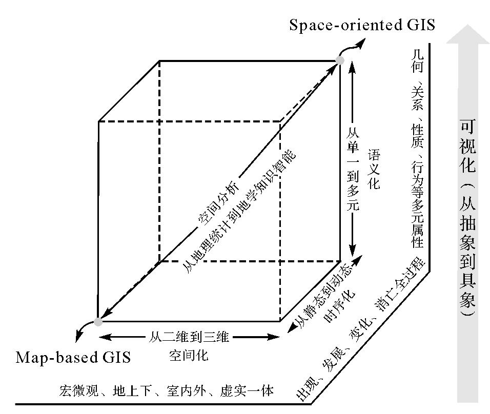
Fig.5
Spatial integration expression based on Space-oriented GIS mode"
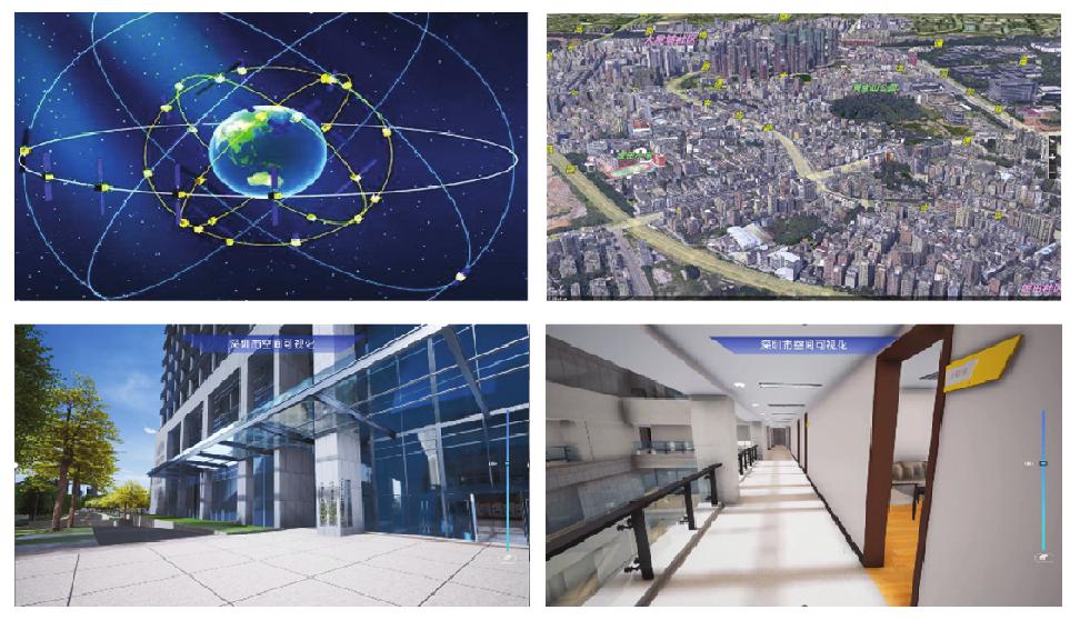
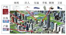
Fig.6
GIS-based smart city operation platform"

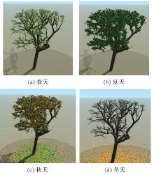
Fig.7
Morphological changes of ancient trees in different seasons"


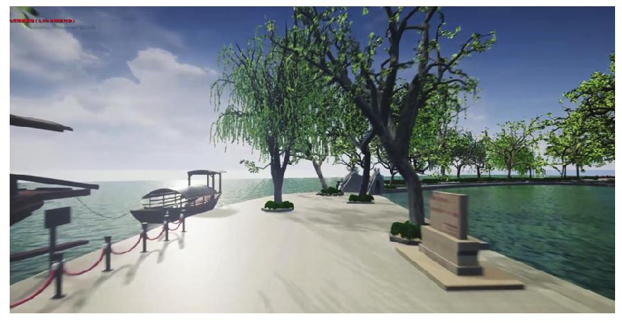
Fig.8
New application of GIS in the field of cultural relics protection"
| [1] |
KALAIVANI S, SARVESWARAN S, RAJESWARY K. Scope of GIS in dental public health: a review[J]. International Journal of Applied Geospatial Research, 2022, 13(1):1-10. DOI:.
doi: 10.4018/IJAGR.298295 |
| [2] | 王家耀. 关于地理信息系统未来发展的思考[J]. 武汉大学学报(信息科学版), 2022, 47(10):1535-1545. |
| WANG Jiayao. Thoughts on the future development of geographic information system[J]. Geomatics and Information Science of Wuhan University, 2022, 47(10):1535-1545. | |
| [3] | 朱秀丽, 赵勇, 刘万增, 等. 测绘地理信息应急快速制图系统研究[J]. 武汉大学学报(信息科学版), 2020, 45(8):1303-1311. |
| ZHU Xiuli, ZHAO Yong, LIU Wanzeng, et al. Geographic information rapid mapping system for emergency[J]. Geomatics and Information Science of Wuhan University, 2020, 45(8):1303-1311. | |
| [4] | 陈军, 刘建军, 田海波. 实景三维中国建设的基本定位与技术路径[J]. 武汉大学学报(信息科学版), 2022, 47(10):1568-1575. |
| CHEN Jun, LIU Jianjun, TIAN Haibo. Basic directions and technological path for building 3D realistic geospatial scene in China[J]. Geomatics and Information Science of Wuhan University, 2022, 47(10):1568-1575. | |
| [5] | WATERS N. GIS: history[M]. The international encyclopedia of geography. Hoboken: John Wiley & Sons, 2017: 1-12. |
| [6] | 华一新. 全空间信息系统的核心问题和关键技术[J]. 测绘科学技术学报, 2016, 33(4):331-335. |
| HUA Yixin. The core problems and key technologies of pan-spatial information system[J]. Journal of Geomatics Science and Technology, 2016, 33(4):331-335. | |
| [7] | LI Wenwen, BATTY M, GOODCHILD M F. Real-time GIS for smart cities[J]. International Journal of Geographical Information Science, 2020, 34(2):311-324. |
| [8] | 张新长, 廖曦, 阮永俭. 智慧城市建设中的数字孪生与元宇宙探讨[J]. 测绘通报, 2023(1):1-7. |
| ZHANG Xinchang, LIAO Xi, RUAN Yongjian. Discussion on digital twin and metaverse in smart city construction[J]. Bulletin of Surveying and Mapping, 2023(1):1-7. | |
| [9] | CHEN Jun, DOWMAN I, LI Songnian, et al. Information from imagery: ISPRS scientific vision and research agenda[J]. ISPRS Journal of Photogrammetry and Remote Sensing, 2016, 115:3-21. |
| [10] | ZHANG Xinchang, LI Shaoying, ZHOU Qiming, et al. Logical and innovative construction of digital twin city[J]. Journal of Geodesy and Geoinformation Science, 2021, 4(4):113-120. |
| [11] |
李德仁, 徐小迪, 邵振峰. 论万物互联时代的地球空间信息学[J]. 测绘学报, 2022, 51(1):1-8. DOI:.
doi: 10.11947/j.AGCS.2022.20210564 |
|
LI Deren, XU Xiaodi, SHAO Zhenfeng. On geospatial information science in the era of IoE[J]. Acta Geodaetica et Cartographica Sinica, 2022, 51(1):1-8. DOI:.
doi: 10.11947/j.AGCS.2022.20210564 |
|
| [12] | 中华人民共和国国家发展和改革委员会. “十四五”数字经济发展规划[EB/OL]. (2022-03-25) [2023-04-10]. https://www.ndrc.gov.cn/fggz/fzzlgh/gjjzxgh/202203/t20220325_1320207.html. |
| National Development and Reform Commission of the People's Republic of China. 14th Five Year Plan for the development of digital economy[EB/OL]. (2022-03-25) [2023-04-10]. https://www.ndrc.gov.cn/fggz/fzzlgh/gjjzxgh/202203/t20220325_1320207.html. | |
| [13] | 自然资源部办公厅. 自然资源部办公厅关于全面推进实景三维中国建设的通知[EB/OL]. (2022-02-24) [2023-04-10]. http://gi.mnr.gov.cn/202202/t20220225_2729401.html. |
| Office of the Ministry of Natural Resources. Notice from the General Office of the Ministry of Natural Resources on fully promoting the construction of realistic 3D China[EB/OL]. (2022-02-24) [2023-04-10]. http://gi.mnr.gov.cn/202202/t20220225_2729401.html. | |
| [14] | GOODCHILD M F. Reimagining the history of GIS[J]. Annals of GIS, 2018, 24(1):1-8. |
| [15] | 王家耀. 地图科学技术:由数字化到智能化[J]. 武汉大学学报(信息科学版), 2022, 47(12):1963-1977. |
| WANG Jiayao. Cartography: from digital to intelligent[J]. Geomatics and Information Science of Wuhan University, 2022, 47(12):1963-1977. | |
| [16] |
郭仁忠, 陈业滨, 马丁, 等. 论ICT时代的泛地图表达[J]. 测绘学报, 2022, 51(7):1108-1113. DOI:.
doi: 10.11947/j.AGCS.2022.20220140 |
|
GUO Renzhong, CHEN Yebin, MA Ding, et al. Pan-map representation in ICT era[J]. Acta Geodaetica et Cartographica Sinica, 2022, 51(7):1108-1113. DOI:.
doi: 10.11947/j.AGCS.2022.20220140 |
|
| [17] | JACQUES B. Semiology of graphics: diagrams, networks, maps[M]. Madison: University of Wisconsin Press, 1983. |
| [18] | LI Z, YAN H, AI T, et al. Automated building generalization based on urban morphology and Gestalt theory[J]. International Journal of Geographical Information Science, 2004, 18(5):513-534. |
| [19] | 郭仁忠, 陈业滨, 应申, 等. 三元空间下的泛地图可视化维度[J]. 武汉大学学报(信息科学版), 2018, 43(11):1603-1610. |
| GUO Renzhong, CHEN Yebin, YING Shen, et al. Geographic visualization of pan-map with the context of ternary spaces[J]. Geomatics and Information Science of Wuhan University, 2018, 43(11):1603-1610. | |
| [20] | 郭仁忠, 陈业滨, 赵志刚, 等. ICT时代地图的科学概念及表达框架[J]. 武汉大学学报(信息科学版), 2022, 47(12):1978-1987. |
| GUO Renzhong, CHEN Yebin, ZHAO Zhigang, et al. Scientific concept and representation framework of maps in the ICT era[J]. Geomatics and Information Science of Wuhan University, 2022, 47(12):1978-1987. | |
| [21] | 郭仁忠, 陈业滨, 赵志刚, 等. 泛地图学理论研究框架[J]. 测绘地理信息, 2021, 46(1):9-15. |
| GUO Renzhong, CHEN Yebin, ZHAO Zhigang, et al. A theoretical framework for the study of pan-maps[J]. Journal of Geomatics, 2021, 46(1):9-15. | |
| [22] | 闾国年, 俞肇元, 袁林旺, 等. 地图学的未来是场景学吗?[J]. 地球信息科学学报, 2018, 20(1):1-6. |
| LÜ Guonian, YU Zhaoyuan, YUAN Linwang, et al. Is the future of cartography the scenario science?[J]. Journal of Geo-information Science, 2018, 20(1):1-6. | |
| [23] | 曾梦熊, 华一新, 张江水, 等. 多粒度时空对象动态行为表达模型与方法研究[J]. 地球信息科学学报, 2021, 23(1):104-112. |
| ZENG Mengxiong, HUA Yixin, ZHANG Jiangshui, et al. Research on dynamic behavior expression model and method of multi-granularity spatio-temporal objects[J]. Journal of Geo-information Science, 2021, 23(1):104-112. | |
| [24] | 艾廷华. 大数据驱动下的地图学发展[J]. 测绘地理信息, 2016, 41(2):1-7. |
| AI Tinghua. Development of cartography driven by big data[J]. Journal of Geomatics, 2016, 41(2):1-7. | |
| [25] | 周成虎. 全空间地理信息系统展望[J]. 地理科学进展, 2015, 34(2):129-131. |
| ZHOU Chenghu. Prospects on pan-spatial information system[J]. Progress in Geography, 2015, 34(2):129-131. | |
| [26] | 华一新, 周成虎. 面向全空间信息系统的多粒度时空对象数据模型描述框架[J]. 地球信息科学学报, 2017, 19(9):1142-1149. |
| HUA Yixin, ZHOU Chenghu. Description frame of data model of multi-granularity spatio-temporal object for pan-spatial information system[J]. Journal of Geo-information Science, 2017, 19(9):1142-1149. | |
| [27] | LÜ G, BATTY M, STROBL J, et al. Reflections and speculations on the progress in geographic information systems (GIS): a geographic perspective[J]. International Journal of Geographical Information Science, 2019, 33(2):346-367. |
| [28] | CHENG Tao, ZHANG Yang, HAWORTH J. Network SpaceTime AI: concepts, methods and applications[J]. Journal of Geodesy and Geoinformation Science, 2022, 5(3):78-92. |
| [29] | 宋关福, 钟耳顺, 周芹, 等. 通用三维GIS场数据模型研究与实践[J]. 测绘地理信息, 2020, 45(2):1-7. |
| SONG Guanfu, ZHONG Ershun, ZHOU Qin, et al. Research and practice on general 3D field data model in GIS[J]. Journal of Geomatics, 2020, 45(2):1-7. | |
| [30] | ZHANG Shuqing, ZHOU Chenghu, ZHANG Junyan, et al. A ubiquitous knowledgeable data representation model(UKRM) for three-dimensional geographic information systems(3D GIS)[J]. Science China Earth Sciences, 2016, 59(4):780-794. |
| [31] | 朱杰, 张宏军. 面向仿真事件的战场地理环境时空过程建模[J]. 武汉大学学报(信息科学版), 2020, 45(9):1367-1377. |
| ZHU Jie, ZHANG Hongjun. Battlefield geographic environment spatiotemporal process model based on simulation event[J]. Geomatics and Information Science of Wuhan University, 2020, 45(9):1367-1377. | |
| [32] | MOORE A, DANIEL B, LEONARD G, et al. Comparative usability of an augmented reality sandtable and 3D GIS for education[J]. International Journal of Geographical Information Science, 2020, 34(2):229-250. |
| [33] | YING Shen, CHEN Naibin, LI Weiyang, et al. Distortion visualization techniques for 3D coherent sets: a case study of 3D building property units[J]. Computers, Environment and Urban Systems, 2019, 78:101382. |
| [34] | ZHAO Linlin, LIU Zhansheng, MBACHU J. Highway alignment optimization: an integrated BIM and GIS approach[J]. ISPRS International Journal of Geo-Information, 2019, 8(4):172. |
| [35] | 朱庆. 三维GIS及其在智慧城市中的应用[J]. 地球信息科学学报, 2014, 16(2):151-157. |
| ZHU Qing. Full three-dimensional GIS and its key roles in smart city[J]. Journal of Geo-information Science, 2014, 16(2):151-157. | |
| [36] | 宁津生. 测绘科学与技术转型升级发展战略研究[J]. 武汉大学学报(信息科学版), 2019, 44(1):1-9. |
| NING Jinsheng. Research on the development strategy of surveying and mapping science and technology transformation and upgrading[J]. Geomatics and Information Science of Wuhan University, 2019, 44(1):1-9. | |
| [37] | 李德仁, 邵振峰, 于文博, 等. 基于时空位置大数据的公共疫情防控服务让城市更智慧[J]. 武汉大学学报(信息科学版), 2020, 45(4):475-487. |
| LI Deren, SHAO Zhenfeng, YU Wenbo, et al. Public epidemic prevention and control services based on big data of spatiotemporal location make cities more smart[J]. Geomatics and Information Science of Wuhan University, 2020, 45(4):475-488. | |
| [38] | PEDRO J, SILVA C, PINHEIRO M D. Integrating GIS spatial dimension into BREEAM communities sustainability assessment to support urban planning policies, Lisbon case study[J]. Land Use Policy, 2019, 83:424-434. |
| [1] | Jinwei BU, Shuhui LIU, Shunshuang XU, Tongsu XIANG, Qiulan WANG, Chaoying JI, Xiaoqing ZUO. Construction of an empirical model for estimating the global wave period of spaceborne GNSS-R [J]. Acta Geodaetica et Cartographica Sinica, 2026, 55(4): 684-697. |
| [2] | Zhongmin MA, Shuangcheng ZHANG, Xin ZHOU, Qi LIU, Ning LIU, Hengli WANG. A flood monitoring method using FY-3 GNSS-R accounting for surface reflectivity uncertainty: a case study of the August 2 Guangdong rainstorm disaster [J]. Acta Geodaetica et Cartographica Sinica, 2026, 55(3): 451-464. |
| [3] | Chenming YE, Zhizhong KANG, Jinhao CAI, Bingzheng ZUO, Shuai SHAO, Yan LI. A morphology-guided real-scene 3D modeling method of lunar geo-entities [J]. Acta Geodaetica et Cartographica Sinica, 2026, 55(3): 525-535. |
| [4] | Dongliang CHENG, Lingqiu CHEN, Zhiyong HUANG, Shubo QIAO, Dandan WANG, Yaming YAN. Performance evaluation of COATS-based multi-mode and multi-frequency iGNSS-R altimetry [J]. Acta Geodaetica et Cartographica Sinica, 2026, 55(1): 73-89. |
| [5] | Shiliang SU, Juan XIANG, Qingyun DU, Lin LI, Qianqian LI, Lingqi WANG, Jiangyue ZHANG, Mengjun KANG, Min WENG. Re-conceptualizing narrative cartography [J]. Acta Geodaetica et Cartographica Sinica, 2025, 54(8): 1371-1388. |
| [6] | Huayi WU, Guangsheng DONG, Rui LI. Virtual trajectories: conceptual characteristics and research framework [J]. Acta Geodaetica et Cartographica Sinica, 2025, 54(6): 967-981. |
| [7] | Biao HE, Renzhong GUO, Hai XU, Xi KUAI, Haojia LIN, Zhigang ZHAO. Concept and technical system of smart city operating system [J]. Acta Geodaetica et Cartographica Sinica, 2025, 54(5): 785-794. |
| [8] | Haopeng FAN, Bojiao ZHANG, Zhongmiao SUN, Jinkai FENG. Prediction method of regional tropospheric wet delay based on Conv-LSTM network [J]. Acta Geodaetica et Cartographica Sinica, 2025, 54(5): 795-804. |
| [9] | Gang LI, Fang XIE, Yifan WU, Jun LU, Shuren GUO, Yingchun LIU, Chengeng SU, Xiaoheng YANG. Prospects for the development of deep space navigation technologies [J]. Acta Geodaetica et Cartographica Sinica, 2025, 54(3): 397-409. |
| [10] | Xiaohu LIN, Xin YANG, Wanqiang YAO, Hongwei MA, Bolin MA, Xiongwei MA. A dynamic weighted fusion SLAM method using multi-source sensor data in complex underground spaces [J]. Acta Geodaetica et Cartographica Sinica, 2025, 54(3): 523-535. |
| [11] | Ziqing WEI. Talk about X-ray pulsar navigation [J]. Acta Geodaetica et Cartographica Sinica, 2025, 54(2): 207-212. |
| [12] | Xiaohua TONG, Rong HUANG, Jiarui CAO, Chen LIU, Rong WANG, Yusheng XU, Zhen YE, Yanmin JIN, Shijie LIU, Sicong LIU, Yongjiu FENG, Huan XIE. Intelligent methods for 3D terrain reconstruction of the Moon and near-Earth planets: a review of current advances and future perspectives [J]. Acta Geodaetica et Cartographica Sinica, 2025, 54(11): 1917-1933. |
| [13] | Shiliang SU, Zichun LI, Qingyun DU, Qianqian LI, Mengjun KANG, Min WENG. Symbols of narrative maps: compositional structure and working mechanism [J]. Acta Geodaetica et Cartographica Sinica, 2025, 54(1): 165-181. |
| [14] | Mi WANG, Tengteng DONG, Tao PENG, Shao XIANG, Qiongqiong LAN. Remote sensing image stripe noise removal model based on detail information constraints [J]. Acta Geodaetica et Cartographica Sinica, 2024, 53(9): 1799-1816. |
| [15] | Zikang SONG, Shuaidong JIA, Zhicheng LIANG, Lihua ZHANG, Chuan LIANG. A reinforcement learning method for collaborative generalization of soundings and depth contours [J]. Acta Geodaetica et Cartographica Sinica, 2024, 53(7): 1345-1354. |
| Viewed | ||||||
|
Full text |
|
|||||
|
Abstract |
|
|||||