

Acta Geodaetica et Cartographica Sinica ›› 2025, Vol. 54 ›› Issue (1): 154-164.doi: 10.11947/j.AGCS.2025.20240067
• Photogrammetry and Remote Sensing • Previous Articles Next Articles
Jialing LI1( ), Ji QI1,2,3, Weipeng LU4, Chao TAO1()
Received:2024-02-17
Revised:2024-11-30
Online:2025-02-17
Published:2025-02-17
Contact:
Chao TAO
E-mail:235011028@csu.edu.cn;kingtaochao@126.com
About author:LI Jialing (2000—), female, postgraduate, majors in semantic segmentation of high resolution remote sensing images based on deep learning, image-language model-driven remote sensing urban functional zone classification. E-mail: 235011028@csu.edu.cn
Supported by:CLC Number:
Jialing LI, Ji QI, Weipeng LU, Chao TAO. Self-supervised learning based urban functional zone classification by integrating optical remote sensing image-OSM data[J]. Acta Geodaetica et Cartographica Sinica, 2025, 54(1): 154-164.
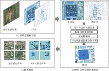
Fig. 1
Data production process for multimodal self-supervised pre-training datasets"

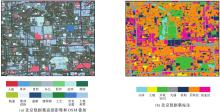
Fig. 2
Coverage of the Beijing dataset"

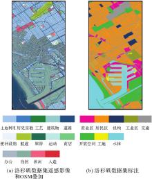
Fig. 3
Coverage of the Los Angeles dataset"

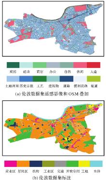
Fig. 4
Coverage of the London dataset"

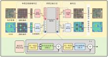
Fig. 5
Structure of the multimodal self-supervised pretraining model"

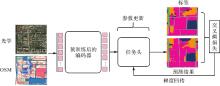
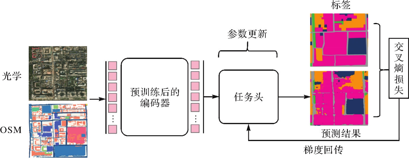
Fig. 6
The fine-tuning of urban functional area classification tasks"
Tab. 1
Quantitative results of comparative experiments on the Beijing dataset"
| 方法 | F1值 | Kappa系数 | ||||||
|---|---|---|---|---|---|---|---|---|
| 交通 | 商业区 | 居民区 | 机构区 | 工地 | 水体 | 开放空间 | ||
| SO-CNN | 0.684 | 0.310 | 0.760 | 0.528 | 0.238 | 0.649 | 0.555 | 0.514 |
| DIHIO | 0.666 | 0.490 | 0.748 | 0.377 | 0.541 | 0.732 | 0.537 | 0.544 |
| RPF | 0.706 | 0.375 | 0.766 | 0.636 | 0.323 | 0.619 | 0.554 | 0.518 |
| 本文方法 | 0.766 | 0.515 | 0.809 | 0.544 | 0.603 | 0.691 | 0.839 | 0.623 |
Tab. 2
Quantitative results of comparative experiments on the Los Angeles dataset"
| 方法 | F1值 | Kappa系数 | |||||||
|---|---|---|---|---|---|---|---|---|---|
| 交通 | 商业区 | 居民区 | 机构区 | 工地 | 水体 | 开放空间 | |||
| SO-CNN | 0.844 | 0.507 | 0.467 | 0.919 | 0.315 | 0.543 | 0.992 | 0.887 | 0.786 |
| DIHIO | 0.627 | 0.736 | 0.589 | 0.945 | 0.630 | 0.653 | 0.995 | 0.856 | 0.774 |
| RPF | 0.783 | 0.420 | 0.298 | 0.866 | 0.310 | 0.210 | 0.939 | 0.839 | 0.741 |
| 本文方法 | 0.708 | 0.810 | 0.948 | 0.849 | 0.790 | 0.912 | 0.899 | 0.932 | 0.827 |
Tab. 3
Quantitative results of comparative experiments on the London dataset"
| 方法 | F1值 | Kappa系数 | |||||||
|---|---|---|---|---|---|---|---|---|---|
| 交通 | 商业区 | 居民区 | 机构区 | 工地 | 水体 | 开放空间 | |||
| SO-CNN | 0.482 | 0.530 | 0.519 | 0.843 | 0.668 | 0.459 | 0.801 | 0.825 | 0.652 |
| DIHIO | 0.397 | 0.414 | 0.480 | 0.842 | 0.647 | 0.557 | 0.695 | 0.787 | 0.612 |
| RPF | 0.410 | 0.426 | 0.464 | 0.835 | 0.579 | 0.366 | 0.640 | 0.822 | 0.613 |
| 本文方法 | 0.772 | 0.542 | 0.474 | 0.933 | 0.693 | 0.494 | 0.889 | 0.928 | 0.791 |
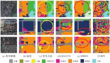
Fig. 7
Comparative results with different methods"
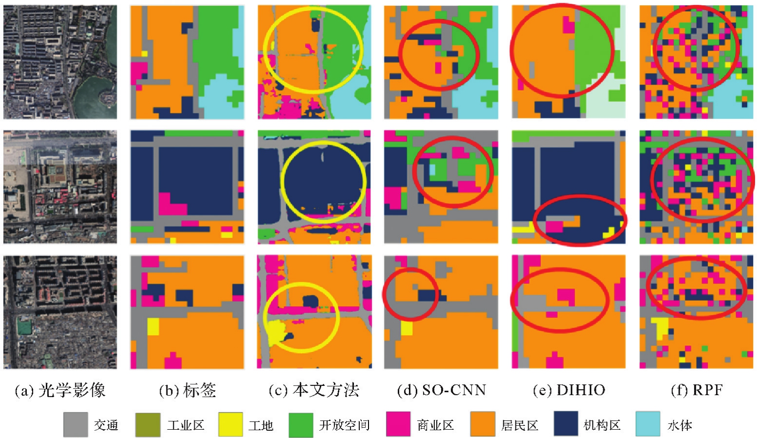

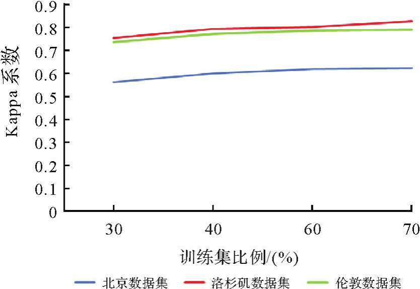
Fig. 8
Variation of Kappa coefficient with proportion of training set inputs"
Tab. 4
Quantitative results of fine-tuning models with different modalities input"
| 微调输入模态 | Kappa系数 | ||
|---|---|---|---|
| 北京数据集 | 洛杉矶数据集 | 伦敦数据集 | |
| 光学 | 0.609 | 0.796 | 0.765 |
| 光学+OSM | 0.623 | 0.827 | 0.791 |
| [1] | 杨小军. 城市遥感:城市环境监测、集成与建模[M]. 肖荣波,译. 北京: 高等教育出版社, 2015. |
| YANG Xiaojun. Urban remote sensing: monitoring, synthesis and modeling in the urban environment[M]. XIAO Rongbo, trans. Beijing: Higher Education Press, 2015. | |
| [2] | CHEN Lai, KANG Chaogui, YANG chao. Understanding citizens' emotion states under the urban livability environment through social media data: a case study of Wuhan[J]. Journal of Geodesy and Geoinformation Science, 2022, 5(2): 49-59. |
| [3] | XIAO Zhifeng, LIU Qing, TANG Gefu, et al. Elliptic Fourier transformation-based histograms of oriented gradients for rotationally invariant object detection in remote-sensing images[J]. International Journal of Remote Sensing, 2015, 36(2): 618-644. |
| [4] | ZHU Qiqi, ZHONG Yanfei, ZHANG Liangpei. Multi-feature probability topic scene classifier for high spatial resolution remote sensing imagery[C]//Proceedings of 2014 IEEE Geoscience and Remote Sensing Symposium. Quebec City: IEEE, 2014: 2854-2857. |
| [5] | WANG Kaijia, XU Weiming, LI Chuyu, et al. A study on the function and structure of mixed land use in urban built-up areas from the perspective of spatial governance[J]. Journal of Natural Resources, 2023, 38(6): 1496. |
| [6] |
龚健雅, 张觅, 胡翔云, 等. 智能遥感深度学习框架与模型设计[J]. 测绘学报, 2022, 51(4): 475-487. DOI:.
doi: 10.11947/j.AGCS.2022.20220027 |
|
GONG Jianya, ZHANG Mi, HU Xiangyun, et al. The design of deep learning framework and model for intelligent remote sensing[J]. Acta Geodaetica et Cartographica Sinica, 2022, 51(4): 475-487. DOI:.
doi: 10.11947/j.AGCS.2022.20220027 |
|
| [7] | GUO Zhou, WEN Jiangtian, XU Rui. A shape and size free-CNN for urban functional zone mapping with high-resolution satellite images and POI data[J]. IEEE Transactions on Geoscience and Remote Sensing, 2023, 61: 5622117. |
| [8] | JOHNSON N, TREIBLE W, CRISPELL D. OpenSentinelMap: a large-scale land use dataset using OpenStreetMap and Sentinel-2 imagery[C]//Proceedings of 2022 IEEE/CVF Conference on Computer Vision and Pattern Recognition Workshops. New Orleans: IEEE, 2022: 1332-1340. |
| [9] | LU Weipeng, TAO Chao, LI Haifeng, et al. A unified deep learning framework for urban functional zone extraction based on multi-source heterogeneous data[J]. Remote Sensing of Environment, 2022, 270: 112830. |
| [10] | GAO Mianxin, GUO Haijing, LIU Longwei, et al. Integrating street view imagery and taxi trajectory for identifying urban function of street space[J/OL]. Geo-spatial Information Science, 2024: 1-23[2023-12-10].https://doi.org/10.1080/10095020.2024.2311866. |
| [11] | SU Chen, HU Xinli, MENG Qingyan, et al. A multimodal fusion framework for urban scene understanding and functional identification using geospatial data[J]. International Journal of Applied Earth Observation and Geoinformation, 2024, 127: 103696. |
| [12] | ZHANG Yan, LIU Pengyuan, BILJECKI F. Knowledge and topology: a two layer spatially dependent graph neural networks to identify urban functions with time-series street view image[J]. ISPRS Journal of Photogrammetry and Remote Sensing, 2023, 198: 153-168. |
| [13] | 鲁伟鹏, 贺清康, 李佳铃, 等. 结合对象单元和Transformer网络的城市功能区分类[J]. 遥感学报, 2024, 28(8): 1927-1939. |
| LU Weipeng, HE Qingkang, LI Jialing, et al. Object units and Transformer networks combined with urban functional zone classification method[J]. National Remote Sensing Bulletin, 2024, 28(8): 1927-1939. | |
| [14] | WU Hao, LUO Wenting, LIN Anqi, et al. SALT: a multifeature ensemble learning framework for mapping urban functional zones from VGI data and VHR images[J]. Computers, Environment and Urban Systems, 2023, 100: 101921. |
| [15] | DU Shouji, DU Shihong, LIU Bo, et al. Large-scale urban functional zone mapping by integrating remote sensing images and open social data[J]. GIScience & Remote Sensing, 2020, 57(3): 411-430. |
| [16] | CAO Rui, TU Wei, YANG Cuixin, et al. Deep learning-based remote and social sensing data fusion for urban region function recognition[J]. ISPRS Journal of Photogrammetry and Remote Sensing, 2020, 163: 82-97. |
| [17] |
张良培, 何江, 杨倩倩, 等. 数据驱动的多源遥感信息融合研究进展[J]. 测绘学报, 2022, 51(7): 1317-1337. DOI:.
doi: 10.11947/j.AGCS.2022.20220171 |
|
ZHANG Liangpei, HE Jiang, YANG Qianqian, et al. Data-driven multi-source remote sensing data fusion: progress and challenges[J]. Acta Geodaetica et Cartographica Sinica, 2022, 51(7): 1317-1337. DOI:.
doi: 10.11947/j.AGCS.2022.20220171 |
|
| [18] | XU Shengyu, QING Linbo, HAN Longmei, et al. A new remote sensing images and point-of-interest fused (RPF) model for sensing urban functional regions[J]. Remote Sensing, 2020, 12(6): 1032. |
| [19] | CHEN Dongsheng, TU Wei, CAO Rui, et al. A hierarchical approach for fine-grained urban villages recognition fusing remote and social sensing data[J]. International Journal of Applied Earth Observation and Geoinformation, 2022, 106: 102661. |
| [20] |
张兵, 杨晓梅, 高连如, 等. 遥感大数据智能解译的地理学认知模型与方法[J]. 测绘学报, 2022, 51(7): 1398-1415. DOI:.
doi: 10.11947/j.AGCS.2022.20220279 |
|
ZHANG Bing, YANG Xiaomei, GAO Lianru, et al. Geo-cognitive models and methods for intelligent interpretation of remotely sensed big data[J]. Acta Geodaetica et Cartographica Sinica, 2022, 51(7): 1398-1415. DOI:.
doi: 10.11947/j.AGCS.2022.20220279 |
|
| [21] | BAI Lubin, HUANG Weiming, ZHANG Xiuyuan, et al. Geographic mapping with unsupervised multi-modal representation learning from VHR images and POIs[J]. ISPRS Journal of Photogrammetry and Remote Sensing, 2023, 201: 193-208. |
| [22] | ZAKERI F, MARIETHOZ G. A review of geostatistical simulation models applied to satellite remote sensing: methods and applications[J]. Remote Sensing of Environment, 2021, 259: 112381. |
| [23] |
陶超, 阴紫薇, 朱庆, 等. 遥感影像智能解译:从监督学习到自监督学习[J]. 测绘学报, 2021, 50(8): 1122-1134. DOI:.
doi: 10.11947/j.AGCS.2021.20210089 |
|
TAO Chao, YIN Ziwei, ZHU Qing, et al. Remote sensing image intelligent interpretation: from supervised learning to self-supervised learning[J]. Acta Geodaetica et Cartographica Sinica, 2021, 50(8): 1122-1134. DOI:.
doi: 10.11947/j.AGCS.2021.20210089 |
|
| [24] | TAO Chao, QI Ji, GUO Mingning, et al. Self-supervised remote sensing feature learning: learning paradigms, challenges, and future works[J]. IEEE Transactions on Geoscience and Remote Sensing, 2023, 61: 1-26. |
| [25] | BACHMANN R, MIZRAHI D, ATANOV A, et al. MultiMAE: multi-modal multi-task masked autoencoders[EB/OL]. [2023-12-10].https://arxiv.org/pdf/2204.01678. |
| [26] | 中国城市规划设计研究院. 城市用地分类与规划建设用地标准:GB 50137—2011[S]. 北京: 中国建筑工业出版社, 2011. |
| China Academy of Urban Planning and Design. Code for classification of urban land use and planning standards of development land: GB 50137—2011[S]. Beijing: China Architecture & Building Press, 2011. | |
| [27] | HE Kaiming, CHEN Xinlei, XIE Saining, et al. Masked autoencoders are scalable vision learners[C]//Proceedings of 2022 IEEE/CVF Conference on Computer Vision and Pattern Recognition. New Orleans: IEEE, 2022: 15979-15988. |
| [28] | DOSOVITSKIY A, BEYER L, KOLESNIKOV A, et al. An image is worth 16×16 words: Transformers for image recognition at scale[EB/OL]. [2023-12-10].https://arxiv.org/pdf/2010.11929. |
| [29] | LIU Zhuang, MAO Hanzi, WU Chaoyuan, et al. A ConvNet for the 2020s[C]//Proceedings of 2022 IEEE/CVF Conference on Computer Vision and Pattern Recognition. New Orleans: IEEE, 2022: 11966-11976. |
| [30] | ZHOU Wen, MING Dongping, LÜ Xianwei, et al. SO-CNN based urban functional zone fine division with VHR remote sensing image[J]. Remote Sensing of Environment, 2020, 236: 111458. |
| [31] | ZHAO Wenzhi, BO Yanchen, CHEN Jiage, et al. Exploring semantic elements for urban scene recognition: deep integration of high-resolution imagery and OpenStreetMap (OSM)[J]. ISPRS Journal of Photogrammetry and Remote Sensing, 2019, 151: 237-250. |
| [32] | GUO Yiwen, TANG Jianbo, LIU Huimin, et al. Identifying up-to-date urban land-use patterns with visual and semantic features based on multisource geospatial data[J]. Sustainable Cities and Society, 2024, 101: 105184. |
| [1] | Zhuang SUN, Po LIU, Liang ZHAI, Yu HE, Zutao ZHANG. A self-supervised matching method for polygonal geographic entity based on a three-branch attention network [J]. Acta Geodaetica et Cartographica Sinica, 2026, 55(1): 169-180. |
| [2] | Wenjian GAN, Yang ZHOU, Xiaofei HU, Luying ZHAO, Gaoshuang HUANG, Mingbo HOU. Combining projective transform and road segmentation for street view-satellite images cross-view geo-localization [J]. Acta Geodaetica et Cartographica Sinica, 2025, 54(8): 1489-1500. |
| [3] | Chao WANG, Tianyu CHEN, Tong ZHANG, Tanvir AHMED, Liqiang JI, Tao XIE, Jiajun YANG, Shuai WANG. Multi-sensor optical remote sensing images change detection based on global differential enhancement module and balance penalty loss [J]. Acta Geodaetica et Cartographica Sinica, 2025, 54(5): 873-887. |
| [4] | Qingdong WANG, Tengfei WANG, Li ZHANG. Cross-modal contrastive masked autoencoder pre-training for 3D real-scene point cloud [J]. Acta Geodaetica et Cartographica Sinica, 2025, 54(4): 675-687. |
| [5] | Zhanlong CHEN, Xiechun LU, Yongyang XU. A building aggregation method based on deep clustering of graph vertices [J]. Acta Geodaetica et Cartographica Sinica, 2024, 53(4): 736-749. |
| [6] | XUE Zhixiang, YU Xuchu, LIU Jingzheng, YANG Guopeng, LIU Bing, YU Anzhu, ZHOU Jianan, JIN Shanghong. A self-supervised pre-training scheme for multi-source heterogeneous remote sensing image land cover classification [J]. Acta Geodaetica et Cartographica Sinica, 2024, 53(3): 512-525. |
| [7] | Qin YAN, Haiyan GU, Yi YANG, Haitao LI, Hengtong SHEN, Shiqi LIU. Research progress and trend of intelligent remote sensing large model [J]. Acta Geodaetica et Cartographica Sinica, 2024, 53(10): 1967-1980. |
| [8] | YU Xuchu, LIU Bing, XUE Zhixiang. Potential analysis and prospect of hyperspectral ground object recognition [J]. Acta Geodaetica et Cartographica Sinica, 2023, 52(7): 1115-1125. |
| [9] | XU Tianhe, LI Song, WANG Shuaimin, JIANG Nan. Improved tropospheric delay model for China using RBF neural network and meteorological data [J]. Acta Geodaetica et Cartographica Sinica, 2022, 51(8): 1690-1707. |
| [10] | FAN Hongchao, KONG Gefei, YANG Anran. Current status and prospects of research for volunteered geographic information [J]. Acta Geodaetica et Cartographica Sinica, 2022, 51(7): 1653-1668. |
| [11] | TAO Chao, YIN Ziwei, ZHU Qing, LI Haifeng. Remote sensing image intelligent interpretation: from supervised learning to self-supervised learning [J]. Acta Geodaetica et Cartographica Sinica, 2021, 50(8): 1122-1134. |
| [12] | FU Peng, SUN Quansen, JI Zexuan. Noise Estimation from Remote Sensing Images by Fractal Theory and Adaptive Image Block Division [J]. Acta Geodaetica et Cartographica Sinica, 2015, 44(11): 1235-1245. |
| Viewed | ||||||
|
Full text |
|
|||||
|
Abstract |
|
|||||