

Acta Geodaetica et Cartographica Sinica ›› 2025, Vol. 54 ›› Issue (5): 853-872.doi: 10.11947/j.AGCS.2025.20240244
• Photogrammetry and Remote Sensing • Previous Articles Next Articles
Haifeng LI1( ), Wang GUO1, Mengwei WU1, Chengli PENG1, Qing ZHU2, Yu LIU3, Chao TAO1()
Received:2024-06-18
Revised:2025-03-27
Online:2025-06-23
Published:2025-06-23
Contact:
Chao TAO
E-mail:lihaifeng@csu.edu.cn;kingtaochao@csu.edu.cn
About author:LI Haifeng (1980—), male, PhD, professor, majors in general-purpose multimodal spatio-temporal foundation models and multimodal spatio-temporal memory models. E-mail: lihaifeng@csu.edu.cn
Supported by:CLC Number:
Haifeng LI, Wang GUO, Mengwei WU, Chengli PENG, Qing ZHU, Yu LIU, Chao TAO. Visual-language joint representation and intelligent interpretation of remote sensing geo-objects: principles, challenges and opportunities[J]. Acta Geodaetica et Cartographica Sinica, 2025, 54(5): 853-872.
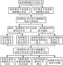
Fig. 1
Overall organizational structure of this paper"
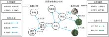
Fig. 2
Composition and interrelationships of the conceptual space for remote sensing geo-objects"
Tab. 1
Expression of geo-entities and geo-concepts by visual and language modalities"
| 地物概念 | 关系属性 | 视觉模态 | 语言模态 | ||
|---|---|---|---|---|---|
| 感知性 | 解析性 | 描述性 | 逻辑性 | ||
| 地物 | 实体属性 | √ | √ | × | × |
| 实体 | 实体关系 | √ | √ | × | × |
| 地物 | 本体属性 | × | √ | √ | √ |
| 本体 | 本体关系 | × | × | × | √ |
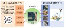
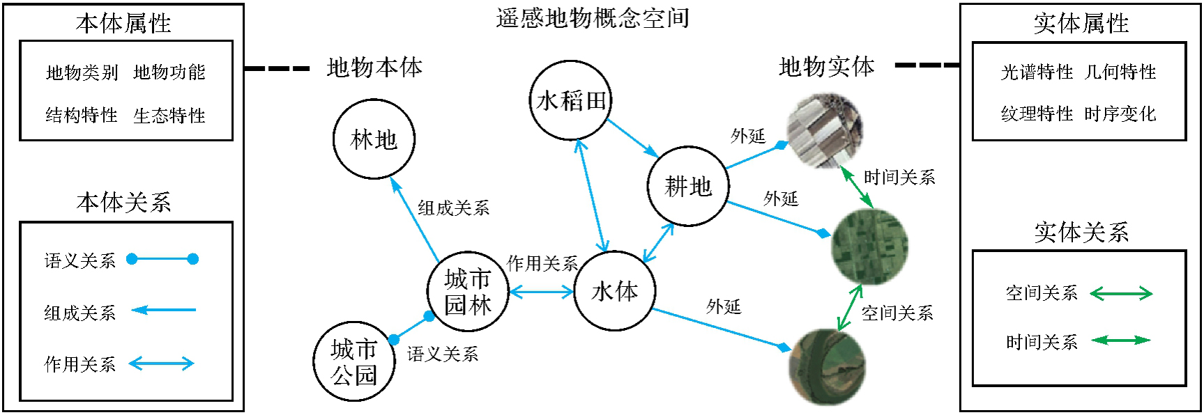
Fig. 3
Geo-object concept description within the unified visual-language conceptual space"
Fig. 4
Different geo-concept attributes for visually similar geo-entities"
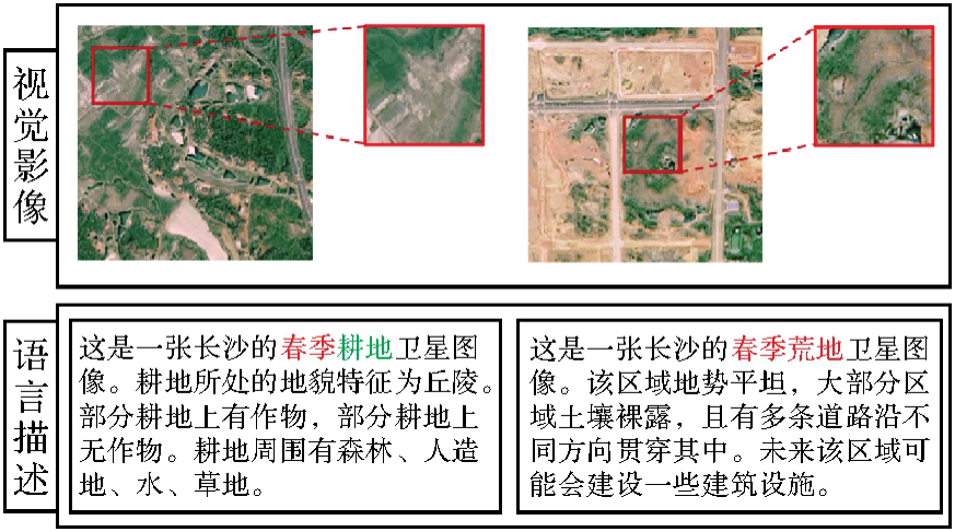
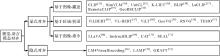
Fig. 5
Overall organizational structure of the remote sensing visual language alignment"
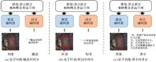
Fig. 6
The explicit alignment method"
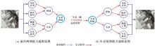
Fig. 7
Emergent abilities of vision-language model"

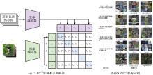
Fig. 8
Zero-shot recognition method and training dataset"
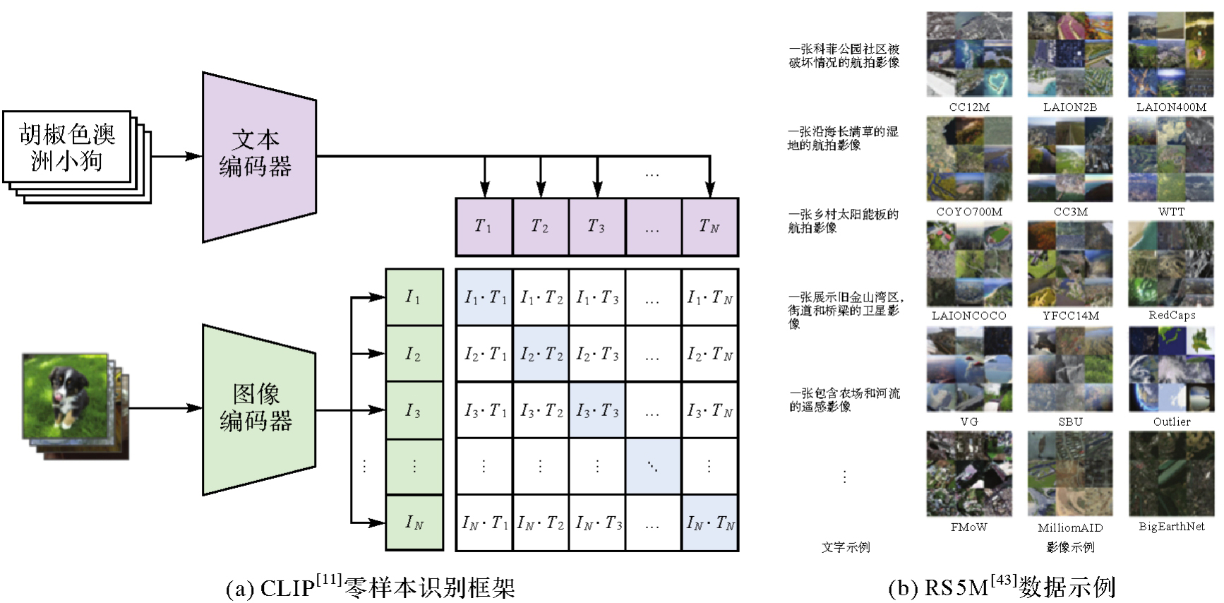
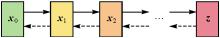
Fig. 9
Diffusion process concept of diffusion model"
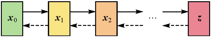
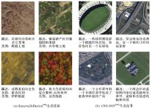
Fig. 10
Examples of text captions and remote sensing image generation results"

Tab. 2
Comparison of classification accuracy (OA)"
| 模型 | 方法 | 视觉骨干网络 | 数据集 | ||
|---|---|---|---|---|---|
| AID | RSC11 | WHU-RS19 | |||
| 视觉模型 | ImageNet[ | 83.00 | 79.68 | 95.63 | |
| SwAV[ | 86.00 | 84.86 | 96.12 | ||
| Barlow Twins[ | ResNet50[ | 88.25 | 85.26 | 97.09 | |
| VICReg[ | 88.10 | 84.46 | 96.60 | ||
| 视觉语言模型 | CLIP[ | 90.95 | 87.65 | 97.57 | |
| RemoteCLIP[ | 94.35 | 91.63 | 98.06 | ||
| 视觉模型 | ImageNet[ | 83.55 | 80.88 | 94.17 | |
| ViTAE[ | ViT-Base[ | 88.30 | 71.31 | 91.74 | |
| 视觉语言模型 | CLIP[ | 94.95 | 86.85 | 97.09 | |
| RemoteCLIP[ | 95.95 | 89.24 | 97.57 | ||
Tab. 3
Comparison of zero-shot scene classification accuracy (OA)"
| 方法 | 数据集 | ||
|---|---|---|---|
| SIRI-WHU | AID | WHU-RS19 | |
| GeoChat[ | 66.63 | 72.03 | 86.47 |
| LHRS-Bot[ | 62.66 | 91.26 | 93.17 |
| H2RSVLM[ | 68.50 | 89.33 | 97.00 |
| SkySenseGPT[ | 74.75 | 92.25 | 97.02 |
Tab. 4
Comparison of few-shot object detection performance (mAP)"
| 模型 | 方法 | 视觉骨干网络 | DIOR | NWPU VHR-10 | ||||
|---|---|---|---|---|---|---|---|---|
| 3例样本 | 5例样本 | 10例样本 | 3例样本 | 5例样本 | 10例样本 | |||
| 视觉模型 | Meta RCNN[ | 14.7 | 15.4 | 19.9 | 6.5 | 11.6 | 15.4 | |
| TFA[ | 20.8 | 21.9 | 26.7 | 13.2 | 16.5 | 14.5 | ||
| FSCE[ | ResNet101[ | 24.9 | 28.3 | 34.8 | 45.6 | 59.0 | 69.5 | |
| 视觉语言模型 | TEMO[ | 30.9 | 37.2 | 42.8 | 57.6 | 66.8 | 75.1 | |
| TSF-RGR[ | — | 42.0 | 49.0 | 57.0 | 66.0 | 77.0 | ||
Tab. 5
Comparison of few-shot semantic segmentation performance (mIoU)"
| 模型 | 方法 | 视觉骨干网络 | ISAID-5I | |
|---|---|---|---|---|
| 1例样本 | 5例样本 | |||
| 视觉模型 | PANet[ | 23.13 | 26.27 | |
| SDM[ | 25.92 | 28.27 | ||
| TBPN[ | ResNet50[ | 23.88 | 26.49 | |
| R2Net[ | 32.71 | 37.36 | ||
| PCNet[ | 32.06 | 36.95 | ||
| 视觉语言模型 | HSE[ | 39.72 | 43.15 | |
Tab. 6
Zero-shot remote sensing image semantic segmentation performance (mIoU)"
| 方法 | 数据集 | |||
|---|---|---|---|---|
| UAVid | LoveDA | Vaihingen | Potsdam | |
| SAM[ | 22.6 | 23.7 | 9.9 | 21.5 |
| SAM[ | 24.1 | 10.2 | 11.5 | 19.7 |
| GDINO[ | 49.4 | 30.5 | 32.2 | 45.3 |
Tab. 7
Comparison of scene recognition accuracy (OA)"
| 方法 | 训练数据 | 识别精度 |
|---|---|---|
| VGG19[ | 真实数据 | 95.72 |
| 生成数据 | 97.28 | |
| ResNet34[ | 真实数据 | 96.11 |
| 生成数据 | 99.22 | |
| ViT-B/32[ | 真实数据 | 93.77 |
| 生成数据 | 94.55 | |
| ViT-B/16[ | 真实数据 | 93.77 |
| 生成数据 | 95.33 |
| [1] |
龚健雅, 许越, 胡翔云, 等. 遥感影像智能解译样本库现状与研究[J]. 测绘学报, 2021, 50(8): 1013-1022. DOI: .
doi: 10.11947/j.AGCS.2021.20210085 |
|
GONG Jianya, XU Yue, HU Xiangyun, et al. Status analysis and research of sample database for intelligent interpretation of remote sensing image[J]. Acta Geodaetica et Cartographica Sinica, 2021, 50(8): 1013-1022. DOI: .
doi: 10.11947/j.AGCS.2021.20210085 |
|
| [2] | 刘大伟, 韩玲, 韩晓勇. 基于深度学习的高分辨率遥感影像分类研究[J]. 光学学报, 2016, 36(4): 428001. |
| LIU Dawei, HAN Ling, HAN Xiaoyong. High spatial resolution remote sensing image classification based on deep learning[J]. Acta Optica Sinica, 2016, 36(4): 428001. | |
| [3] | 李石华, 王金亮, 毕艳, 等. 遥感图像分类方法研究综述[J]. 国土资源遥感, 2005, 17(2): 1-6. |
| LI Shihua, WANG Jinliang, BI Yan, et al. A review of methods for classification of remote sensing images[J]. Remote Sensing for Land & Resources, 2005, 17(2): 1-6. | |
| [4] | 徐丰, 王海鹏, 金亚秋. 深度学习在SAR目标识别与地物分类中的应用[J]. 雷达学报, 2017, 6(2): 136-148. |
| XU Feng, WANG Haipeng, JIN Yaqiu. Deep learning as applied in SAR target recognition and terrain classification[J]. Journal of Radars, 2017, 6(2): 136-148. | |
| [5] | 聂光涛, 黄华. 光学遥感图像目标检测算法综述[J]. 自动化学报, 2021, 47(8): 1749-1768. |
| NIE Guangtao, HUANG Hua. A survey of object detection in optical remote sensing images[J]. Acta Automatica Sinica, 2021, 47(8): 1749-1768. | |
| [6] | ZHANG Xiangrong, ZHANG Tianyang, WANG Guanchun, et al. Remote sensing object detection meets deep learning: a metareview of challenges and advances[J]. IEEE Geoscience and Remote Sensing Magazine, 2023, 11(4): 8-44. |
| [7] | SUBRAMANYAM R, JAYRAM T S, ANIRUDH R, et al. CREPE: learnable prompting with CLIP improves visual relationship prediction[EB/OL]. [2024-01-20]. https://arxiv.org/abs/2307.04838v2. |
| [8] | 农元君, 王俊杰, 赵雪冰, 等. 遥感目标空间关系检测方法[J]. 光学学报, 2021, 41(16): 1628001. |
| NONG Yuanjun, WANG Junjie, ZHAO Xuebing, et al. Spatial relationship detection method of remote sensing objects[J]. Acta Optica Sinica, 2021, 41(16): 1628001. | |
| [9] | DU Yifan, LIU Zikang, LI Junyi, et al. A survey of vision-language pre-trained models[EB/OL]. [2024-01-20]. https://arxiv.org/abs/2202.10936v2. |
| [10] | WANG Z R, YU J H, YU A W, et al. SimVLM: simple visual language model pretraining with weak supervision[EB/OL]. [2024-01-20]. https://arxiv.org/abs/2108.10904v3. |
| [11] | RADFORD A, KIM J W, HALLACY C, et al. Learning transferable visual models from natural languagesupervision[C]//Proceedings of 2021 International Conference on Machine Learning. [S.l.]: PMLR, 2021: 8748-8763. |
| [12] | YANG Z Y, LI L J, LIN K, et al. The dawn of LMMs: preliminary explorations with GPT-4V (ision)[EB/OL]. [2024-01-20]. https://arxiv.org/abs/2309.17421v2. |
| [13] | ALAYRAC J B, DONAHUE J, LUC P, et al. Flamingo: a visual language model for few-shot learning[J]. Advances in Neural Information Processing Systems, 2022, 35: 23716-23736. |
| [14] | LIN T Y, MAIRE M, BELONGIE S, et al. Microsoft COCO: common objects in context[C]//Proceedings of 2014 ECCV. Zurich: Springer International Publishing, 2014: 740-755. |
| [15] | KRISHNA R, ZHU Y K, GROTH O, et al. Visual genome: connecting language and vision using crowdsourced dense image annotations[J]. International Journal of Computer Vision, 2017, 123(1): 32-73. |
| [16] | SCHUHMANN C, BEAUMONT R, VENCU R, et al. LAION-5B: an open large-scale dataset for training next generation image-text models[C]//Proceedings of the 36th International Conference on Neural Information Processing Systems. Red Hook: Curran Associates Inc., 2022: 25278-25294. |
| [17] | 张良培, 张乐飞, 袁强强. 遥感大模型:进展与前瞻[J]. 武汉大学学报(信息科学版), 2023, 48(10): 1574-1581. |
| ZHANG Liangpei, ZHANG Lefei, YUAN Qiangqiang. Large remote sensing model: progress and prospects[J]. Geomatics and Information Science of Wuhan University, 2023, 48(10): 1574-1581. | |
| [18] | SHAO Run, YANG Cheng, LI Qiujun, et al. AllSpark: a multimodal spatio-temporal general intelligence model with ten modalities via language as a reference framework[EB/OL]. [2023-12-20]. https://arxiv.org/abs/2401.00546v3. |
| [19] | LIU F, CHEN D L, GUAN Z, et al. RemoteCLIP: a vision language foundation model for remote sensing[EB/OL]. [2024-01-20]. https://arxiv.org/abs/2306.11029v4. |
| [20] | ZHANG Jingyi, HUANG Jiaxing, JIN Sheng, et al. Vision-language models for vision tasks: a survey[J]. IEEE Transactions on Pattern Analysis and Machine Intelligence, 2024, 46(8): 5625-5644. |
| [21] | LI Xiang, WEN Congcong, HU Yuan, et al. Vision-language models in remote sensing: current progress and future trends[EB/OL]. [2024-01-20]. https://arxiv.org/abs/2305.05726v2. |
| [22] | 诸云强, 孙凯, 王曙, 等. 顾及复杂时空特征及关系的地球科学知识图谱自适应表达模型[J]. 中国科学:地球科学, 2023, 53(11): 2609-2622. |
| ZHU Yunqiang, SUN Kai, WANG Shu, et al. An adaptive representation model for geoscience knowledge graphs considering complex spatiotemporal features and relationships[J]. Scientia Sinica (Terrae), 53(11): 2609-2622. | |
| [23] | 顾海燕, 李海涛, 闫利, 等. 地理本体驱动的遥感影像面向对象分析方法[J]. 武汉大学学报(信息科学版), 2018, 43(1): 31-36. |
| GU Haiyan, LI Haitao, YAN Li, et al. A geographic object-based image analysis methodology based on geo-ontology[J]. Geomatics and Information Science of Wuhan University, 2018, 43(1): 31-36. | |
| [24] | 孙敏, 陈秀万, 张飞舟. 地理信息本体论[J]. 地理与地理信息科学, 2004, 20(3): 6-11. |
| SUN Min, CHEN Xiuwan, ZHANG Feizhou. Geo-ontology[J]. Geography and Geo-Information Science, 2004, 20(3): 6-11. | |
| [25] | 李霖, 王红, 赵宁, 等. 基于本体论的基础地理信息分类研究[J]. 地理信息世界, 2004 (6): 21-25. |
| LI Lin, WANG Hong, ZHAO Ning, et al. Classification of fundamental geographical information based on ontology[J]. Geomatics World, 2004 (6): 21-25. | |
| [26] | 李彦胜, 张永军. 耦合知识图谱和深度学习的新一代遥感影像解译范式[J]. 武汉大学学报(信息科学版), 2022, 47(8): 1176-1190. |
| LI Yansheng, ZHANG Yongjun. A new paradigm of remote sensing image interpretation by coupling knowledge graph and deep learning[J]. Geomatics and Information Science of Wuhan University, 2022, 47(8): 1176-1190. | |
| [27] | 王志华, 杨晓梅, 周成虎. 面向遥感大数据的地学知识图谱构想[J]. 地球信息科学学报, 2021, 23(1): 16-28. |
| WANG Zhihua, YANG Xiaomei, ZHOU Chenghu. Geographic knowledge graph for remote sensing big data[J]. Journal of Geo-information Science, 2021, 23(1): 16-28. | |
| [28] | 刘峤, 李杨, 段宏, 等. 知识图谱构建技术综述[J]. 计算机研究与发展, 2016, 53(3): 582-600. |
| LIU Qiao, LI Yang, DUAN Hong, et al. Knowledge graph construction techniques[J]. Journal of Computer Research and Development, 2016, 53(3): 582-600. | |
| [29] | VINYALS O, TOSHEV A, BENGIO S, et al. Show and tell: a neural image caption generator[C]//Proceedings of 2015 IEEE Conference on Computer Vision and Pattern Recognition. Boston: IEEE, 2015: 3156-3164. |
| [30] | REED S, AKATA Z, YAN X, et al. Generative adversarial text to image synthesis[EB/OL]//Proceedings of 2016 International Conference on Machine Learning. [S.l.]: PMLR, 2016: 1060-1069. |
| [31] | ALEC R, KIM J M, CHRIS H. Learning transferable visual models from natural language supervision[C]//Proceedings of 2021 International Conference on Machine Learning. [S.l.]: ICML, 2021: 1-16. |
| [32] | LIU Jing, ZHU Xinxin, LIU Fei, et al. OPT: omni-perception pre-trainer for cross-modal understanding and generation[EB/OL]. [2024-01-20]. https://arxiv.org/abs/2107.00249v2. |
| [33] | ADENIJI A, XIE A, SFERRAZZA C, et al. Language reward modulation for pretraining reinforcement learning[EB/OL]. [2024-01-20]. https://arxiv.org/abs/2308.12270v1. |
| [34] | PANG Ziqi, XIE Ziyang, MAN Yunze, et al. Frozen transformers in language models are effective visual encoder layers[EB/OL]. [2024-01-20]. https://arxiv.org/abs/2310.12973v2. |
| [35] | YANG Jianwei, LI Chunyuan, ZHANG Pengchuan, et al. Unified contrastive learning in image-text-label space[C]//Proceedings of 2022 IEEE/CVF Conference on Computer Vision and Pattern Recognition. New Orleans: IEEE, 2022. |
| [36] | SHEN S, LI C, HU X, et al. K-lite: learning transferable visual models with external knowledge[J]. Advances in Neural Information Processing Systems, 2022, 35: 15558-15573. |
| [37] | FAN L, KRISHNAN D, ISOLA P, et al. Improving CLIP training with language rewrites[EB/OL]. [2024-01-02]. https://arxiv.org/pdf/2305.20088. |
| [38] | LI Junnan, LI Dongxu, XIONG Caiming, et al. BLIP: Bootstrapping language-image pre-training for unified vision-language understanding and generation[EB/OL]. [2024-01-02]. https://arxiv.org/pdf/2201.12086. |
| [39] | QU Bo, LI Xuelong, TAO Dacheng, et al. Deep semantic understanding of high resolution remote sensing image[C]//Proceedings of 2016 International Conference on Computer, Information and Telecommunication Systems. Kunming: IEEE, 2016: 1-5. |
| [40] | YANG Y, NEWSAM S. Bag-of-visual-words and spatial extensions for land-use classification[C]//Proceedings of 2020 SIGSPA-TIAL International Conference on Advances in Geographic Information Systems. San Jose: ACM Press, 2010: 270-279. |
| [41] | LU Xiaoqiang, WANG Binqiang, ZHENG Xiangtao, et al. Exploring models and data for remote sensing image caption generation[J]. IEEE Transactions on Geoscience and Remote Sensing, 2018, 56(4): 2183-2195. |
| [42] | YUAN Zhiqiang, ZHANG Wenkai, FU Kun, et al. Exploring a fine-grained multiscale method for cross-modal remote sensing image retrieval[EB/OL]. [2023-12-02]. https://arxiv.org/abs/2204.09868. |
| [43] | ZHANG Zilun, ZHAO Tiancheng, GUO Yulong, et al. RS5M: a large scale vision-language dataset for remote sensing vision-language foundation model[EB/OL]. [2023-12-02]. https://arxiv.org/abs/2306.11300. |
| [44] | VASWANI A. Attention is all you need[EB/OL]. [2023-12-02]. https://arxiv.org/abs/1706.03762. |
| [45] | LU J S, BATRA D, PARIKH D, et al. ViLBERT: pretraining task-agnostic visiolinguistic representations for vision-and-language tasks[EB/OL]. [2024-02-01]. https://arxiv.org/abs/1908.02265. |
| [46] | HE K M, GKIOXARI G, DOLLÁR P, et al. Mask R-CNN[C]//Proceedings of 2017 IEEE International Conference on Computer Vision. Venice: IEEE, 2017. |
| [47] | SU Weijie, ZHU Xizhou, CAO Yue, et al. VL-BERT: pre-training of generic visual-linguistic representations[EB/OL]. [2023-12-02]. https://arxiv.org/abs/1908.08530. |
| [48] | KIM W, SON B, KIM I. ViLT: vision-and-language transformer without convolution or region supervision[EB/OL]. [2023-12-02]. https://arxiv.org/abs/2102.03334. |
| [49] | YANG Lingfeng, WANG Yueze, LI Xiang, et al. Fine-grained visual prompting[EB/OL]. [2024-01-02]. https://arxiv.org/abs/2306.04356. |
| [50] | SUN Zeyi, FANG Ye, WU Tong, et al. Alpha-CLIP: a clip model focusing on wherever you want[EB/OL]. [2024-01-02]. https://arxiv.org/abs/2312.03818. |
| [51] | WANG Weiyun, SHI Min, LI Qingyun, et al. The all-seeing project: towards panoptic visual recognition and understanding of the open world[EB/OL]. [2024-01-02]. https://arxiv.org/abs/2308.01907. |
| [52] | SHI Zhenwei, ZOU Zhengxia. Can a machine generate humanlike language descriptions for a remote sensing image?[J]. IEEE Transactions on Geoscience and Remote Sensing, 2017, 55(6): 3623-3634. |
| [53] | ZHANG Xueting, WANG Qi, CHEN Shangdong, et al. Multi-scale cropping mechanism for remote sensing image captioning[C]//Proceedings of 2019 IEEE International Geoscience and Remote Sensing Symposium. Yokohama: IEEE, 2019: 10039-10042. |
| [54] | ZHAO Rui, SHI Zhenwei, ZOU Zhengxia. High-resolution remote sensing image captioning based on structured attention[J]. IEEE Transactions on Geoscience and Remote Sensing, 2022, 60: 5603814. |
| [55] | SUN Yuxi, FENG Shanshan, LI Xutao, et al. Visual grounding in remote sensing images[C]//Proceedings of the 30th ACM International Conference on Multimedia. Lisboa: ACM Press, 2022: 404-412. |
| [56] | ZHAN Yang, XIONG Zhitong, YUAN Yuan. RSVG: exploring data and models for visual grounding on remote sensing data[J]. IEEE Transactions on Geoscience and Remote Sensing, 2023, 61: 1-13. |
| [57] | LU Xiaonan, SUN Xian, DIAO Wenhui, et al. Few-shot object detection in aerial imagery guided by text-modal knowledge[J]. IEEE Transactions on Geoscience and Remote Sensing, 2023, 61: 3250448. |
| [58] | LIU C, YANG S, SABA-SADIYA S, et al. Jointly learning grounded task structures from language instruction and visual demonstration[C]//Proceedings of 2016 Conference on Empirical Methods in Natural Language Processing. Austin: ACL, 2016: 1482-1492. |
| [59] | REN M, KIROS R, ZEMEL R. Exploring models and data for image question answering[EB/OL]. [2024-01-02]. https://arxiv.org/abs/1505.02074. |
| [60] | YAMASHITA R, NISHIO M, DO R K G, et al. Convolutional neural networks: an overview and application in radiology[J]. Insights into Imaging, 2018, 9: 611-629. |
| [61] | MEDSKER L R, JAIN L. Recurrent neural networks[J]. Design and Applications, 2001, 5(64-67): 2. |
| [62] | HOCHREITER S, SCHMIDHUBER J. Long short-term memory[J]. Neural computation, 1997, 9(8): 1735-1780. |
| [63] | LOBRY S, MARCOS D, MURRAY J, et al. RSVQA: visual question answering for remote sensing data[J]. IEEE Transactions on Geoscience and Remote Sensing, 2020, 58(12): 8555-8566. |
| [64] | OpenAI. Introduction ChatGPT[EB/OL]. [2024-01-20]. https://openai.com/blog/chatgpt/. |
| [65] | LI L H, YATSKAR M, YIN D, et al. VisualBERT: a simple and performant baseline for vision and language[EB/OL]. [2024-01-02]. https://arxiv.org/abs/1908.03557v1. |
| [66] | TAN H, BANSAL M. LXMERT: learning cross-modality encoder representations from transformers[EB/OL]. [2024-01-02]. https://arxiv.org/abs/1908.07490v3. |
| [67] | AL RAHHAL M M, BAZI Y, ALSALEH S Oingyang, et al. Open-ended remote sensing visual question answering with transformers[J]. International Journal of Remote Sensing, 2022, 43(18): 6809-6823. |
| [68] | LIU Haotian, LI Chunyuan, WU Qingyang, et al. Visual instruction tuning[EB/OL]. [2024-01-02]. https://arxiv.org/abs/2304.08485. |
| [69] | DAI Wenliang, LI Junnan, LI Dorgxu, et al. InstructBLIP: towards general-purpose vision-language models with instruction tuning[EB/OL]. [2024-01-02]. https://arxiv.org/abs/2305.06500. |
| [70] | WANG Teng, ZHANG Jinrui, FEI Junjie, et al. Caption anything: interactive image description with diverse multimodal controls[EB/OL]. [2024-01-02]. https://arxiv.org/abs/2305.02677v3. |
| [71] | WU Penghao, XIE Saining. V*: guided visual search as a core mechanism in multimodal LLMs[EB/OL]. [2024-01-02]. https://arxiv.org/abs/2312.14135v2. |
| [72] | HUH M, CHEUNG B, WANG Tongzhou, et al. The platonic representation hypothesis[EB/OL]. [2024-01-02]. https://arxiv.org/abs/2405.07987v5. |
| [73] | MANIPARAMBIL M, AKSHULAKOV R, DJILALI Y A D, et al. Do vision and language encoders represent the world similarly?[EB/OL]. [2023-12-02]. https://arxiv.org/abs/2401.05224v2. |
| [74] | MALL U, PHOO C P, LIU M K, et al. Remote sensing vision-language foundation models without annotations via ground remote alignment[EB/OL]. [2024-01-02]. https://arxiv.org/abs/2312.06960v1. |
| [75] | CHURCH K W. Word2Vec[J]. Natural Language Engineering, 2017, 23(1): 155-162. |
| [76] | PENNINGTON J, SOCHER R, MANNING C D. GloVe: global vectors for word representation[C]//Proceedings of 2014 Conference on Empirical Methods in Natural Language Processing. Stroudsburg: ACL, 2014: 1532-1543. |
| [77] | JOULIN A, GRAVE E, BOJANOWSKI P, et al. FastText.zip: compressing text classification models[EB/OL]. [2024-01-02]. https://arxiv.org/abs/1612.03651v1. |
| [78] | KODIROV E, XIANG Tao, GONG Shaogang. Semantic autoencoder for zero-shot learning[C]//Proceedings of 2017 IEEE Conference on Computer Vision and Pattern Recognition. Honolulu: IEEE, 2017: 3174-3183. |
| [79] | 吴晨, 王宏伟, 袁昱纬, 等. 基于图像特征融合的遥感场景零样本分类算法[J]. 光学学报, 2019, 39(6): 0610002. |
| WU Chen, WANG Hongwei, YUAN Yuwei, et al. Image feature fusion based remote sensing scene zero-shot classification algorithm[J]. Acta Optica Sinica, 2019, 39(6): 0610002. | |
| [80] |
李彦胜, 孔德宇, 张永军, 等. 联合稳健跨域映射和渐进语义基准修正的零样本遥感影像场景分类[J]. 测绘学报, 2020, 49(12): 1564-1574. DOI: .
doi: 10.11947/j.AGCS.2020.20200139 |
|
LI Yansheng, KONG Deyu, ZHANG Yongjun, et al. Zero-shot remote sensing image scene classification based on robust cross- domain mapping and gradual refinement of semantic space[J]. Acta Geodaetica et Cartographica Sinica, 2020, 49(12): 1564-1574. DOI: .
doi: 10.11947/j.AGCS.2020.20200139 |
|
| [81] | SARZYNSKA-WAWER J, WAWER A, PAWLAK A, et al. Detecting formal thought disorder by deep contextualized word representations[J]. Psychiatry Research, 2021, 304: 114135. |
| [82] | DEVLIN J, CHANG Mingwei, LEE K, et al. BERT: pre-training of deep bidirectional transformers for language understanding[EB/OL]. [2024-01-02]. https://arxiv.org/abs/1810.04805v2. |
| [83] | BROWN T, MANN B, RYDER N, et al. Language models are few-shot learners[J]. Advances in Neural Information Processing Systems, 2020, 33: 1877-1901. |
| [84] | JIA Chao, YANG Yinfei, XIA Ye, et al. Scaling up visual and vision-language representation learning with noisy text supervision[EB/OL]. [2024-01-02]. https://arxiv.org/abs/2102.05918. |
| [85] | HO J, JAIN A, ABBEEL P. Denoising diffusion probabilistic models[J]. Advances in Neural Information Processing Systems, 2020, 33: 6840-6851. |
| [86] | CAO Zihan, CAO Shiqi, WU Xiao, et al. DDRF: denoising diffusion model for remote sensing image fusion[EB/OL]. [2024-01-02]. https://arxiv.org/abs/2304.04774v1. |
| [87] | LIU Jinzhe, YUAN Zhiqiang, PAN Zhaoying, et al. Diffusion model with detail complement for super-resolution of remote sensing[J]. Remote Sensing, 2022, 14(19): 4834. |
| [88] | KASODEKAR K S. Remote diffusion[EB/OL]. [2023-12-02]. https://arxiv.org/abs/2405.04717v1. |
| [89] | TANG Datao, CAO Xiangyong, HOU Xingsong, et al. CRS-Diff: controllable generative remote sensing foundation model[EB/OL]. [2023-12-02]. https://arxiv.org/html/2403.11614v3. |
| [90] | KHANNA S, LIU P, ZHOU Linqi, et al. DiffusionSat: a generative foundation model for satellite imagery[EB/OL]. [2024-01-02]. https://arxiv.org/abs/2312.03606v2. |
| [91] | HE Kaiming, ZHANG Xiangyu, REN Shaoqing, et al. Deep residual learning for image recognition[C]//Proceedings of 2016 IEEE Conference on Computer Vision and Pattern Recognition. Las Vegas: IEEE, 2016: 770-778. |
| [92] | DOSOVITSKIY A. An image is worth 16×16 words: Transformers for image recognition at scale[EB/OL]. [2024-01-02]. https://arxiv.org/abs/2010.11929. |
| [93] | XIA Guisong, HU Jingwen, HU Fan, et al. AID: a benchmark data set for performance evaluation of aerial scene classification[J]. IEEE Transactions on Geoscience and Remote Sensing, 2017, 55(7): 3965-3981. |
| [94] | ZHAO Lijun, TANG Ping, HUO Lianzhi. Feature significance-based multibag-of-visual-words model for remote sensing image scene classification[J]. Journal of Applied Remote Sensing, 2016, 10(3): 035004. |
| [95] | XIA Guisong, YANG Wen, DELON J, et al. Structural high-resolution satellite image indexing[C]//Proceedings of 2010 ISPRS TC VII Symposium-100 Years ISPRS. Vienna: [s.n.], 2010: 298-303. |
| [96] | DENG Jia, DONG Wei, SOCHER R, et al. ImageNet: a large-scale hierarchical image database[C]//Proceedings of 2009 IEEE Conference on Computer Vision and Pattern Recognition. Miami: IEEE, 2009: 248-255. |
| [97] | CARON M, MISRA I, MAIRAL J, et al. Unsupervised learning of visual features by contrasting cluster assignments[J]. Advances in Neural Information Processing Systems, 2020, 33: 9912-9924. |
| [98] | ZBONTAR J, JING L, MISRA I, et al. Barlow twins: self-supervised learning via redundancy reduction[EB/OL]. [2024-01-02]. https://arxiv.org/abs/2103.03230. |
| [99] | DBARDES A, PONCE J, LECUN Y. VICReg: variance-invariance-covariance regularization for self-supervised learning[EB/OL]. [2024-01-02]. https://arxiv.org/abs/2105.04906v3. |
| [100] | XU Yufei, ZHANG Qiming, ZHANG Jing, et al. ViTAE: vision transformer advanced by exploring intrinsic inductive bias[J]. Advances in Neural Information Processing Systems, 2021, 34: 28522-28535. |
| [101] | KUCKREJA K, DANISH M S, NASEER M, et al. GeoChat: grounded large vision-language model for remote sensing[C]//Proceedings of 2024 IEEE/CVF Conference on Computer Vision and Pattern Recognition. [S.l.]: IEEE, 2024: 27831-27840. |
| [102] | MUHTAR D, LI Zhenshi, GU Feng, et al. LHRS-bot: empowering remote sensing with VGI-enhanced large multimodal language model[EB/OL]. [2023-12-02]. https://arxiv.org/abs/2402.02544v4. |
| [103] | PANG Chao, WU Jiang, LI Jiayu, et al. H2RSVLM: towards helpful and honest remote sensing large vision language model[EB/OL]. [2023-12-02]. https://arxiv.org/abs/2403.20213. |
| [104] | LUO Junwei, PANG Zhen, ZHANG Yongjun, et al. SkySenseGPT: a fine-grained instruction tuning dataset and model for remote sensing vision-language understanding[EB/OL]. [2023-12-02]. https://arxiv.org/abs/2406.10100v2. |
| [105] | ZHU Qiqi, ZHONG Yanfei, ZHAO Bei, et al. Bag-of-visual-words scene classifier with local and global features for high spatial resolution remote sensing imagery[J]. IEEE Geoscience and Remote Sensing Letters, 2016, 13(6): 747-751. |
| [106] | ZHANG Sanxing, SONG Fei, LIU Xianyuan, et al. Text semantic fusion relation graph reasoning for few-shot object detection on remote sensing images[J]. Remote Sensing, 2023, 15(5): 1187. |
| [107] | YAN Xiaopeng, CHEN Ziliang, XU Anni, et al. Meta R-CNN: towards general solver for instance-level low-shot learning[C]//Proceedings of 2019 IEEE/CVF International Conference on Computer Vision. Seoul: IEEE, 2019: 9577-9586. |
| [108] | WANG Xin, HUANG T E, DARRELL T, et al. Frustratingly simple few-shot object detection[EB/OL]. [2023-12-02]. https://arxiv.org/abs/2003.06957v1. |
| [109] | SUN Bo, LI Banghuai, CAI Shengcai, et al. FSCE: few-shot object detection via contrastive proposal encoding[C]//Proceedings of 2021 IEEE/CVF Conference on Computer Vision and Pattern Recognition. Nashville: IEEE, 2021. |
| [110] | LI Xiang, DENG Jingyu, FANG Yi. Few-shot object detection on remote sensing images[J]. IEEE Transactions on Geoscience and Remote Sensing, 2022, 60: 5601614. |
| [111] | LI Ke, WAN Gang, CHENG Gong, et al. Object detection in optical remote sensing images: a survey and a new benchmark[J]. ISPRS Journal of Photogrammetry and Remote Sensing, 2020, 159: 296-307. |
| [112] | WANG Kaixin, LIEW J H, ZOU Yingtian, et al. PANet: few-shot image semantic segmentation with prototype alignment[C]//Proceedings of 2019 IEEE/CVF International Conference on Computer Vision. Seoul: IEEE, 2019. |
| [113] | PUTHUMANAILLAM G, VERMA U. Texture based prototypical network for few-shot semantic segmentation of forest cover: generalizing for different geographical regions[J]. Neurocomputing, 2023, 538: 126201. |
| [114] | LANG Chunbo, WANG Junyi, CHENG Gong, et al. Progressive parsing and commonality distillation for few-shot remote sensing segmentation[J]. IEEE Transactions on Geoscience and Remote Sensing, 2023, 61: 3286183. |
| [115] | JIA Yuyu, HUANG Wei, GAO Junyu, et al. Embedding generalized semantic knowledge into few-shot remote sensing segmentation[EB/OL]. [2023-12-02]. https://arxiv.org/abs/2405.13686v1. |
| [116] | YAO Xiwen, CAO Qinglong, FENG Xiaoxu, et al. Scale-aware detailed matching for few-shot aerial image semantic segmentation[J]. IEEE Transactions on Geoscience and Remote Sensing, 2022, 60: 3119852. |
| [117] | XIE Guosen, LIU Jie, XIONG Huan, et al. Scale-aware graph neural network for few-shot semantic segmentation[C]//Proceedings of 2021 EEE/CVF Conference on Computer Vision and Pattern Recognition. Nashville: IEEE, 2021. |
| [118] | LANG Chunbo, CHENG Gong, TU Binfei, et al. Global rectification and decoupled registration for few-shot segmentation in remote sensing imagery[J]. IEEE Transactions on Geoscience and Remote Sensing, 2023, 61: 3301003. |
| [119] | KIRILLOV A, MINTUN E, RAVI N, et al. Segment anything[C]//Proceedings of 2023 IEEE/CVF International Conference on Computer Vision. Paris: IEEE, 2023: 4015-4026. |
| [120] | LIU Shilong, ZENG Zhaoyang, REN Tianhe, et al. Grounding DINO: marrying DINO with grounded pre-training for open-set object detection[C]//Proceedings of 2025 European Conference on Computer Vision. Cham: Springer, 2025: 38-55. |
| [121] | ZHANG Jielu, ZHOU Zhongliang, MAI Gengchen, et al. Text2Seg: zero-shot remote sensing image semantic segmentation via text-guided visual foundation models[C]//Proceedings of the 7th ACM SIGSPATIAL International Workshop on AI for Geographic Knowledge Discovery. Atlanta: ACM Press, 2024: 63-66. |
| [122] | LI Yi, WANG Hualiang, DUAN Yiqun, et al. Clip surgery for better explainability with enhancement in open-vocabulary tasks[EB/OL]. [2023-12-02]. https://arxiv.org/abs/2304.05653. |
| [123] | LÜ Ye, VOSSELMAN G, XIA Guisong, et al. UAVid: a semantic segmentation dataset for UAV imagery[J]. ISPRS Journal of Photogrammetry and Remote Sensing, 2020, 165: 108-119. |
| [124] | WANG Junjue, ZHENG Zhuo, MA Ailong, et al. LoveDA: a remote sensing land-cover dataset for domain adaptive semantic segmentation[EB/OL]. [2023-12-02]. https://arxiv.org/abs/2110.08733v6. |
| [125] | ROTTENSTEINER F, SOHN G, JUNG J, et al. The ISPRS benchmark on urban object classification and 3D building reconstruction[J]. ISPRS Annals of the Photogrammetry, Remote Sensing and Spatial Information Sciences, 2012, 1(1): 293-298. |
| [126] | YU Zhiping, LIU Chenyang, LIU Liqin, et al. MetaEarth: a generative foundation model for global-scale remote sensing image generation[EB/OL]. [2023-12-02]. https://arxiv.org/abs/2405.13570v3. |
| [127] | SIMONYAN K, ZISSERMAN A. Very deep convolutional networks for large-scale image recognition[EB/OL]. [2023-12-02]. https://arxiv.org/abs/1409.1556. |
| [128] | KOERNER E F. The Sapir-Whorf hypothesis: a preliminary history and a bibliographical essay[J]. Journal of Linguistic Anthropology, 1992, 2(2): 173-198. |
| [1] | TAO Chao, YIN Ziwei, ZHU Qing, LI Haifeng. Remote sensing image intelligent interpretation: from supervised learning to self-supervised learning [J]. Acta Geodaetica et Cartographica Sinica, 2021, 50(8): 1122-1134. |
| Viewed | ||||||
|
Full text |
|
|||||
|
Abstract |
|
|||||