

Acta Geodaetica et Cartographica Sinica ›› 2025, Vol. 54 ›› Issue (7): 1170-1177.doi: 10.11947/j.AGCS.2025.20250020
• Geodesy and Navigation • Previous Articles Next Articles
Jianzhang LI1,2,3( ), Haowen YAN1,2,3(), Weifang YANG1,2,3, Xiaoning SU1,2,3
Received:2025-01-14
Revised:2025-06-26
Online:2025-08-18
Published:2025-08-18
Contact:
Haowen YAN
E-mail:lijianzhang@mail.lzjtu.cn;haowen2010@gmail.com
About author:LI Jianzhang (1974—), male, PhD, associate professor, majors in data processing of high speed railway control network. E-mail: lijianzhang@mail.lzjtu.cn
Supported by:CLC Number:
Jianzhang LI, Haowen YAN, Weifang YANG, Xiaoning SU. GNSS pseudo trigonometric leveling method[J]. Acta Geodaetica et Cartographica Sinica, 2025, 54(7): 1170-1177.

Fig. 1
GNSS pseudo trigonometric leveling schematic diagram"
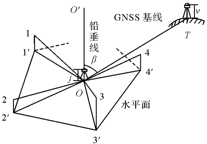

Fig. 2
E and auxiliary point distribution"


Fig. 3
F and auxiliary point distribution"

Tab. 1
Geodetic coordinates of each point"
| 点号 | 纬度 | 经度 | 大地高/m |
|---|---|---|---|
| E | 36°07′44.359 04″N | 103°43′34.945 72″E | 16 59.894 90 |
| K0D1 | 36°07′46.008 40″N | 103°43′32.565 63″E | 1 659.999 00 |
| K0D2 | 36°07′45.503 66″N | 103°43′35.870 95″E | 1 660.485 90 |
| K0D3 | 36°07′43.282 04″N | 103°43′38.833 00″E | 1 660.631 00 |
| K0D4 | 36°07′41.589 45″N | 103°43′36.472 20″E | 1 659.497 90 |
| K0D5 | 36°07′42.348 62″N | 103°43′32.256 22″E | 1 658.404 20 |
| F | 36°09′31.171 04″N | 103°43′11.497 58″E | 1 754.421 20 |
| K0H1 | 36°09′30.509 53″N | 103°43′08.706 11″E | 1 753.236 89 |
| K0H2 | 36°09′32.485 81″N | 103°43′09.251 00″E | 1 754.929 80 |
| K0H3 | 36°09′35.220 34″N | 103°43′12.667 73″E | 1 757.545 80 |
| K0H4 | 36°09′33.847 61″N | 103°43′15.185 55″E | 1 757.535 67 |
| K0H5 | 36°09′30.131 09″N | 103°43′13.794 09″E | 1 754.902 51 |
Tab. 2
Height difference from the center point to each auxiliary point"
| 测段号 | 高差 | 测段号 | 高差 |
|---|---|---|---|
| E-K0D1 | 0.105 10 | F-K0H1 | -1.183 10 |
| E-K0D2 | 0.590 20 | F-K0H2 | 0.509 60 |
| E-K0D3 | 0.732 30 | F-K0H3 | 3.123 90 |
| E-K0D4 | -0.397 70 | F-K0H4 | 3.112 00 |
| E-K0D5 | -1.488 90 | F-K0H5 | 0.479 50 |
Tab. 3
The projection of the baseline vector from the center point to each auxiliary point on the horizontal plane"
| 基线名 | ΔX | ΔY | ΔZ |
|---|---|---|---|
| E-K0D1 | 64.943 30 | -15.013 16 | 41.087 32 |
| E-K0D2 | -17.435 90 | -25.590 33 | 28.388 39 |
| E-K0D3 | -98.931 02 | -3.952 88 | -26.891 12 |
| E-K0D4 | -48.879 61 | 39.894 30 | -68.977 13 |
| E-K0D5 | 56.689 40 | 51.457 18 | -50.053 20 |
| F-K0H1 | 64.947 50 | 28.242 25 | -16.467 29 |
| F-K0H2 | 60.239 00 | -9.913 80 | 32.727 79 |
| F-K0H3 | -10.950 47 | -78.497 92 | 100.798 64 |
| F-K0H4 | -78.027 48 | -69.167 95 | 66.629 02 |
| F-K0H5 | -60.266 59 | 4.761 39 | -25.885 99 |
Tab. 4
Other experimental results"
| 序号 | 水准线路长/km | GNSS伪三角高程测量高差/m | 精密水准测量高差/m | 较差/mm | 二等水准测量限差/mm | |||
|---|---|---|---|---|---|---|---|---|
| 往测 | 反测 | 平均 | 中误差 | |||||
| 1 | 2.5 | 65.935 3 | -66.819 6 | 66.377 5 | 0.004 2 | 66.381 0 | -3.5 | 9.4 |
| 2 | 2.5 | 65.933 1 | -66.817 4 | 66.375 3 | 0.003 6 | 66.381 0 | -5.7 | 9.4 |
| 3 | 3.8 | 95.329 1 | -97.082 9 | 96.206 0 | 0.004 1 | 96.210 6 | -4.6 | 11.7 |
| 4 | 3.8 | 95.335 0 | -97.089 0 | 96.212 0 | 0.003 9 | 96.210 6 | 1.4 | 11.7 |
| [1] | 蒋利龙. 精密EDM三角高程测量中的折光改正实用方法[J]. 测绘科学, 2006, 31(6): 129-130, 132, 8-9. |
| JIANG Lilong. A practicable method of correction for atmospheric refraction in precise EDM trigonometric leveling[J]. Science of Surveying and Mapping, 2006, 31(6): 129-130, 132, 8-9. | |
| [2] | 杨立华, 高平和. 三角高程测量中“两差”改正系数C的确定方法[J]. 长春工程学院学报(自然科学版), 2009, 10(3): 83-85. |
| YANG Lihua, GAO Pinghe. Method for determine double-difference correction coefficient C in triangle leveling[J]. Journal of Changchun Institute of Technology (Natural Sciences Edition), 2009, 10(3): 83-85. | |
| [3] | 刘念, 盛新蒲. 三角高程测量中大气折光影响的分析[J]. 测绘科学, 2012, 37(6): 26-28, 36. |
| LIU Nian, SHENG Xinpu. Influence of atmospheric refraction in trigonometric leveling[J]. Science of Surveying and Mapping, 2012, 37(6): 26-28, 36. | |
| [4] | 刘新峰. 大气竖直折光对三角高程测量影响因素的研究[J]. 东华理工大学学报(自然科学版), 2016, 39(): 166-168. |
| LIU Xinfeng. Study on the influence factors of atmospheric vertical refraction on trigonometric leveling[J]. Journal of East China University of Technology (Natural Science), 2016, 39(): 166-168. | |
| [5] | 王欢, 刘成龙, 杨雪峰, 等. 大气折光系数测定及在悬索桥基准索股线形测量中的应用[J]. 测绘通报, 2019(5): 129-133. |
| WANG Huan, LIU Chenglong, YANG Xuefeng, et al. Surveying and calculating single-refraction coefficient and using in surveying the linear of datum strand of suspension bridge[J]. Bulletin of Surveying and Mapping, 2019(5): 129-133. | |
| [6] | 张正禄, 邓勇, 罗长林, 等. 精密三角高程代替一等水准测量的研究[J]. 武汉大学学报(信息科学版), 2006, 31(1): 5-8. |
| ZHANG Zhenglu, DENG Yong, LUO Changlin, et al. Research on precise triangulated height surveying in place of first order leveling[J]. Geomatics and Information Science of Wuhan University, 2006, 31(1): 5-8. | |
| [7] | 白少云, 杨琦. 基于MS05AX测量机器人的精密三角高程误差来源与精度分析[J]. 测绘通报, 2015(2): 58-63. |
| BAI Shaoyun, YANG Qi. Analysis of errors and precision for precise triangulated height based on MS05AX measuring robots[J]. Bulletin of Surveying and Mapping, 2015(2): 58-63. | |
| [8] | 郑德华. 精密测距三角高程精度分析及高程混合网定权[J]. 同济大学学报(自然科学版), 2004, 32(4): 507-512. |
| ZHENG Dehua. Accuracy analysis of subtend trigonometric leveling and determination of weight matrix for adjustment of elevation mixed network[J]. Journal of Tongji University (Natural Science), 2004, 32(4): 507-512. | |
| [9] | 施一民. 现代大地控制测量[M]. 2版. 北京: 测绘出版社, 2008. |
| SHI Yimin. Contemporary geodetic control survey[M]. 2nd ed. Beijing: Surveying and Mapping Press, 2008. | |
| [10] | 徐亚明, 施斌, 王代雄, 等. 改进的三角高程法在跨海高程传递中的应用[J]. 测绘通报, 2014(4): 65-67, 78. |
| XU Yaming, SHI Bin, WANG Daixiong, et al. An improved trigonometric leveling method for cross-sea elevation transfer[J]. Bulletin of Surveying and Mapping, 2014(4): 65-67, 78. | |
| [11] | 吴迪军, 李剑坤, 何广源. 三角高程法超长距离跨海高程传递实验研究[J]. 测绘科学, 2017, 42(12): 195-200. |
| WU Dijun, LI Jiankun, HE Guangyuan. Study of extra-long distance sea-crossing elevation transference based on trigonometric levelling[J]. Science of Surveying and Mapping, 2017, 42(12): 195-200. | |
| [12] | 王文利, 王斌, 马新莹, 等. 2020年珠峰三角高程测量数据处理与结果分析[J]. 测绘科学, 2022, 47(10): 96-104, 131. |
| WANG Wenli, WANG Bin, MA Xinying, et al. 2020 Mount Qomolangma triangle elevation survey data processing and result analysis[J]. Science of Surveying and Mapping, 2022, 47(10): 96-104, 131. | |
| [13] | 李志伟, 李克昭, 赵磊杰. 精密三角高程测量在港珠澳青州航道桥中的应用[J]. 测绘工程, 2016, 25(9): 35-39. |
| LI Zhiwei, LI Kezhao, ZHAO Leijie. Application of precise trigonometric leveling measurement to the Hong Kong-Zhuhai-Macao bridge Qingzhou channel bridge[J]. Engineering of Surveying and Mapping, 2016, 25(9): 35-39. | |
| [14] | LI J, YAN H. Parameter method data processing for CPⅢ precise trigonometric leveling network[J]. Journal of Geodesy and Geoinformation Science, 2020, 3(3): 67-75. |
| [15] | 张恒, 胡波, 袁长征. 精密三角高程代替二等水准实现跨河水准测量的研究与应用[J]. 测绘通报, 2019(11): 121-125. |
| ZHANG Heng, HU Bo, YUAN Changzheng. Research and application of precise trigonometric leveling to replace second-class leveling achieving river-crossing leveling[J]. Bulletin of Surveying and Mapping, 2019(11): 121-125. | |
| [16] | 郝旦, 王芬. 自动照准全站仪精密三角高程测量在跨河水准测量中的应用[J]. 测绘通报, 2019(3): 159-162. |
| HAO Dan, WANG Fen. Application of precision trigonometric elevation measurement in river-crossing leveling based on autocollimation total station[J]. Bulletin of Surveying and Mapping, 2019(3): 159-162. | |
| [17] | 赖鸿斌, 马德英, 梅熙, 等. 山区二等三角高程测量方法的应用研究[J]. 铁道工程学报, 2012, 29(6): 15-19, 23. |
| LAI Hongbin, MA Deying, MEI Xi, et al. Application research on the second trigonometric leveling method in mountain area[J]. Journal of Railway Engineering Society, 2012, 29(6): 15-19, 23. | |
| [18] | 韩昀, 程新文, 刘成, 等. 精密三角高程代替二等水准测量在山区铁路勘测中的运用[J]. 测绘科学, 2011, 36(4): 106-107. |
| HAN Yun, CHENG Xinwen, LIU Cheng, et al. Application of precision triangle elevation instead of second-order leveling in the use of railway survey in the mountains area[J]. Science of Surveying and Mapping, 2011, 36(4): 106-107. | |
| [19] | 邹进贵, 朱勇超, 童魁. 精密三角高程测量技术在高海拔山区的应用[J]. 测绘地理信息, 2013, 38(6): 6-9. |
| ZOU Jingui, ZHU Yongchao, TONG Kui. Application of precise trigonometric leveling technology at high altitude[J]. Journal of Geomatics, 2013, 38(6): 6-9. | |
| [20] | 邹进贵, 徐亚明, 潘正风, 等. 基于TCRP1201全站仪的高程自动测量系统开发与应用研究[J]. 测绘通报, 2007(12): 30-33. |
| ZOU Jingui, XU Yaming, PAN Zhengfeng, et al. The research on the development and application of auto-height surveying system based on TCRP1201 total station[J]. Bulletin of Surveying and Mapping, 2007(12): 30-33. | |
| [21] | 刘成龙, 杨雪峰, 张阅川. 基于测量机器人的二等高程控制测量新方法[J]. 西南交通大学学报, 2013, 48(1): 69-74. |
| LIU Chenglong, YANG Xuefeng, ZHANG Yuechuan. New method of second-order height control surveying based on georobot[J]. Journal of Southwest Jiaotong University, 2013, 48(1): 69-74. | |
| [22] | 肖根旺, 许提多, 周文健, 等. 高精度三角高程测量的严密公式[J]. 测绘通报, 2004(10): 15-17, 45. |
| XIAO Genwang, XU Tiduo, ZHOU Wenjian, et al. The strict formula of high precise trigonometric leveling[J]. Bulletin of Surveying and Mapping, 2004(10): 15-17, 45. | |
| [23] | 程效军, 鲍峰, 顾孝烈. 测量学[M]. 5版. 上海: 同济大学出版社, 2016. |
| CHENG Xiaojun, BAO Feng, GU Xiaolie. Elementary surveying[M]. 5th ed. Shanghai: Tongji University Press, 2016. | |
| [24] | 潘正风, 程效军, 成枢, 等. 数字地形测量学[M]. 武汉: 武汉大学出版社, 2015. |
| PAN Zhengfeng, CHENG Xiaojun, CHENG Shu, et al. Digital topographic survey[M]. Wuhan: Wuhan University Press, 2015. | |
| [25] | 张正禄. 工程测量学[M]. 2版. 武汉: 武汉大学出版社, 2013. |
| ZHANG Zhenglu. Engineering surveying[M]. 2nd ed. Wuhan: Wuhan University Press, 2013. | |
| [26] | 国家质量监督检验检疫总局, 中国国家标准化管理委员会. 国家一、二等水准测量规范:GB/T 12897—2006E[S]. 北京: 中国标准出版社, 2006. |
| General Administration of Quality Supervision, Inspection and Quarantine of the People's Republic of China, Standardization Administration of the People's Republic of China. Specifications for the first and second order leveling: GB/T 12897—2006E[S]. Beijing: Standards Press of China, 2006. |
| [1] | ZHANG Chuanyin, MA Xu, ZHANG Lei, DING Jian. Accuracy assessment method of geoid based on GNSS-leveling and gravity field error characteristics [J]. Acta Geodaetica et Cartographica Sinica, 2021, 50(1): 12-17. |
| [2] | LI Jianzhang, YAN Haowen. Parameter method data processing for CPⅢ precise trigonometric leveling network [J]. Acta Geodaetica et Cartographica Sinica, 2019, 48(4): 431-438. |
| [3] | WANG Wenli, GUO Chunxi, DING Li, ZHAO Hong. Elevation change analysis of the national first order leveling points in recent 20 years [J]. Acta Geodaetica et Cartographica Sinica, 2019, 48(1): 1-8. |
| [4] | WU Fumei, WEI Ziqing, LIU Guangming. Determination of the Vertical Deviation for China Height Datum with Coordinates of Dagang Tidal Gauge [J]. Acta Geodaetica et Cartographica Sinica, 2018, 47(10): 1295-1300. |
| [5] | ZHANG Chuanyin, JIANG Tao, KE Baogui, WANG Wei. The Analysis of Height System Definition and the High Precision GNSS Replacing Leveling Method [J]. Acta Geodaetica et Cartographica Sinica, 2017, 46(8): 945-951. |
| [6] | LI Jiancheng, CHU Yonghai, XU Xinyu. Determination of Vertical Datum Offset between the Regional and the Global Height Datum [J]. Acta Geodaetica et Cartographica Sinica, 2017, 46(10): 1262-1273. |
| [7] | HE Lin, LI Jiancheng, CHU Yonghai. The Vertical Shift between 1985 National Height Datum and Global Vertical Datum [J]. Acta Geodaetica et Cartographica Sinica, 2016, 45(7): 768-774. |
| [8] | . Evaluation and analysis of GOCE earth gravity field model in Qinghai-Tibet region [J]. Acta Geodaetica et Cartographica Sinica, 2014, 43(1): 21-29. |
| Viewed | ||||||
|
Full text |
|
|||||
|
Abstract |
|
|||||