

Acta Geodaetica et Cartographica Sinica ›› 2026, Vol. 55 ›› Issue (2): 315-327.doi: 10.11947/j.AGCS.2026.20250451
• Geodesy and Navigation • Previous Articles Next Articles
Qingyun YAN1( ), Zixuan GUO1, Yuanjin PAN1, Yan JIA2, Shuanggen JIN1,3()
Received:2025-10-30
Revised:2026-01-11
Online:2026-03-13
Published:2026-03-13
Contact:
Shuanggen JIN
E-mail:003257@nuist.edu.cn;sgjin@hpu.edu.cn
About author:YAN Qingyun (1992—), male, PhD, associate professor, majors in GNSS-R remote sensing. E-mail: 003257@nuist.edu.cn
Supported by:CLC Number:
Qingyun YAN, Zixuan GUO, Yuanjin PAN, Yan JIA, Shuanggen JIN. Quantitative driving factors and zoning patterns of GNSS-R land surface reflectivity spatial heterogeneity[J]. Acta Geodaetica et Cartographica Sinica, 2026, 55(2): 315-327.
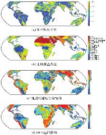
Fig. 1
Spatial data distribution"
Tab. 1
Selection of model driving factors for geographic detectors"
| 表征类型 | 驱动因子 | 因变量 |
|---|---|---|
| 地形 | 坡向 | 地表反射率 |
| 地形高程 | ||
| 粗糙度 | ||
| 坡度 | ||
| 植被 | 生物量 | |
| 叶面积指数 | ||
| 归一化植被指数 | ||
| 树干高 | ||
| 植被含水量 | ||
| 植被光学厚度 | ||
| 土壤 | 土壤湿度 | |
| 地表覆盖 | 土地覆盖类型 |
Tab. 2
Driving factors explaining the spatial variation in reflectivity (q value)"
| 驱动因子 | q值 |
|---|---|
| 粗糙度 | 0.203 3 |
| 地形高程 | 0.180 0 |
| 土地覆盖类型 | 0.146 3 |
| 坡度 | 0.104 0 |
| 植被光学厚度 | 0.078 1 |
| 树干高 | 0.050 6 |
| 归一化植被指数 | 0.046 1 |
| 生物量 | 0.044 3 |
| 叶面积指数 | 0.042 1 |
| 植被含水量 | 0.040 0 |
| 土壤湿度 | 0.011 7 |
| 坡向 | 0.005 2 |
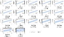
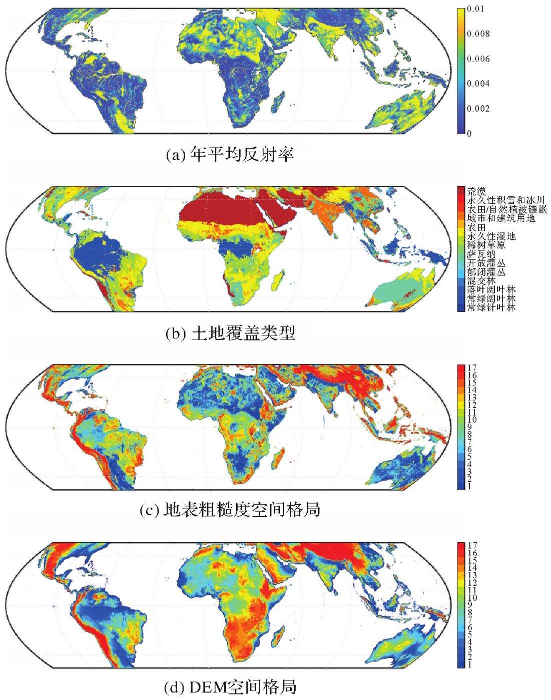
Fig. 2
Univariate regression of SM"
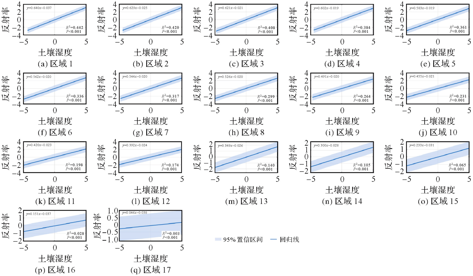
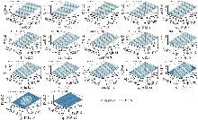
Fig. 3
Bivariate regression of SM+VWC"
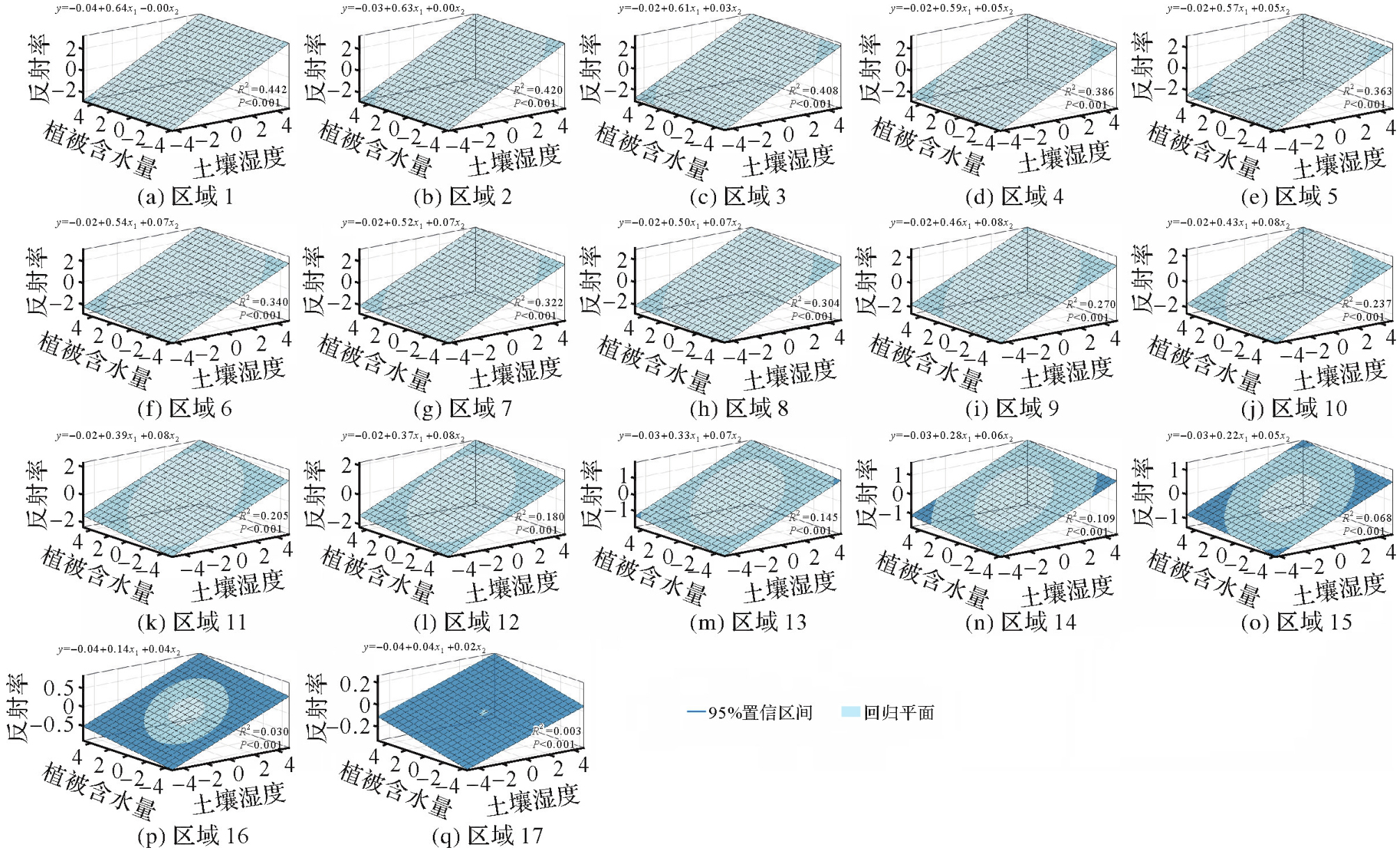
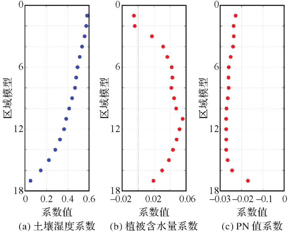
Fig. 4
Multiple regression of SM+VWC+PN"
Tab. 3
Three-predictor regression model:results of fitting and statistical tests"
| 区域模型 | 决定系数 | F检验 | 样本量 |
|---|---|---|---|
| 区域1 | 0.490 | P<0.01 | 3 045 056 |
| 区域2 | 0.472 | P<0.01 | 2 817 486 |
| 区域3 | 0.461 | P<0.01 | 2 550 345 |
| 区域4 | 0.441 | P<0.01 | 2 452 543 |
| 区域5 | 0.425 | P<0.01 | 2 519 719 |
| 区域6 | 0.407 | P<0.01 | 2 613 219 |
| 区域7 | 0.391 | P<0.01 | 2 710 157 |
| 区域8 | 0.374 | P<0.01 | 2 811 814 |
| 区域9 | 0.345 | P<0.01 | 2 888 756 |
| 区域10 | 0.316 | P<0.01 | 2 918 090 |
| 区域11 | 0.287 | P<0.01 | 2 904 416 |
| 区域12 | 0.262 | P<0.01 | 2 907 206 |
| 区域13 | 0.228 | P<0.01 | 2 891 118 |
| 区域14 | 0.194 | P<0.01 | 2 933 460 |
| 区域15 | 0.152 | P<0.01 | 2 934 648 |
| 区域16 | 0.103 | P<0.01 | 2 914 891 |
| 区域17 | 0.039 | P<0.01 | 2 495 777 |
Tab. 4
WeightedR2 as a function of zoning scheme and input parameters"
| 分区类型 | 输入参数 | 加权R2 |
|---|---|---|
| 粗糙度 | SM | 0.243 3 |
| SM、VWC | 0.246 7 | |
| SM、VWC、PN | 0.315 2 | |
| 地形高程 | SM | 0.225 0 |
| SM、VWC | 0.228 9 | |
| SM、VWC、PN | 0.303 1 | |
| 土地覆盖类型 | SM | 0.238 2 |
| SM、VWC | 0.239 3 | |
| SM、VWC、PN | 0.316 5 | |
| 粗糙度+土壤湿度 | SM | 0.250 3 |
| SM、VWC | 0.252 7 | |
| SM、VWC、PN | 0.323 8 | |
| 粗糙度+植被 | SM | 0.254 5 |
| SM、VWC | 0.256 0 | |
| SM、VWC、PN | 0.326 8 |
Tab. 5
R2 Comparison of models under different overlay zoning"
| 分区组合 | 自变量 | 加权R2(9类分区) | 加权R2(16类分区) |
|---|---|---|---|
| 粗糙度+土壤湿度 | SM | 0.243 9 | 0.248 5 |
| SM、VWC | 0.246 5 | 0.250 9 | |
| SM、VWC、PN | 0.318 1 | 0.322 3 | |
| 粗糙度+植被 | SM | 0.246 6 | 0.252 0 |
| SM、VWC | 0.248 8 | 0.253 5 | |
| SM、VWC、PN | 0.319 9 | 0.324 5 |
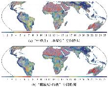
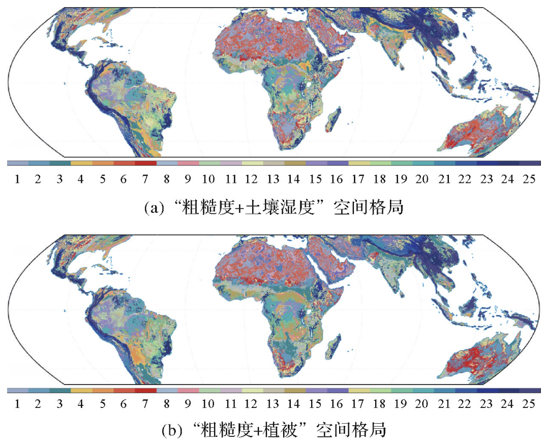
Fig. 5
Zones distribution"
| [1] | YAN Qingyun, HUANG Weimin. Sea ice remote sensing using GNSS-R: a review[J]. Remote Sensing, 2019, 11(21): 2565. |
| [2] | 李黄, 夏青, 尹聪, 等. 我国GNSS-R遥感技术的研究现状与未来发展趋势[J]. 雷达学报, 2013, 2(4): 389-399. |
| LI Huang, XIA Qing, YIN Cong, et al. The current status of research on GNSS-R remote sensing technology in China and future development[J]. Journal of Radars, 2013, 2(4): 389-399. | |
| [3] | MARTIN-NEIRA M. A passive reflectometry and interferometry system (PARIS): application to ocean altimetry[J]. ESA Journal, 1993, 17(4): 331-355. |
| [4] | RUF C, LYONS A, UNWIN M, et al. CYGNSS: enabling the future of hurricane prediction[J]. IEEE Geoscience and Remote Sensing Magazine, 2013, 1(2): 52-67. |
| [5] | LI Bowen, YANG Dongkai, ZHANG Bo. Simulation of multi-satellite GNSS reflected signals and design of simulator[J]. Journal of Geodesy and Geoinformation Science, 2021, 4(2): 36-46. |
| [6] | QIAO Xin, YAN Qingyun, HUANG Weimin. Hybrid CNN-Transformer network with a weighted MSE loss for global sea surface wind speed retrieval from GNSS-R data[J]. IEEE Transactions on Geoscience and Remote Sensing, 2025, 63: 4207013. |
| [7] | LIU Yunxiang, COLLETT I, MORTON JADE Y. Application of neural network to GNSS-R wind speed retrieval[J]. IEEE Transactions on Geoscience and Remote Sensing, 2019, 57(12): 9756-9766. |
| [8] |
布金伟, 余科根, 汪秋兰, 等. 融合星载GNSS-R数据和多变量参数全球海洋有效波高深度学习反演法[J]. 测绘学报, 2024, 53(7): 1321-1335. DOI: .
doi: 10.11947/j.AGCS.2024.20230050 |
|
BU Jinwei, YU Kegen, WANG Qiulan, et al. Deep learning retrieval method for global ocean significant wave height by integrating spaceborne GNSS-R data and multivariable parameters[J]. Acta Geodaetica et Cartographica Sinica, 2024, 53(7): 1321-1335. DOI: .
doi: 10.11947/j.AGCS.2024.20230050 |
|
| [9] | YAN Qingyun, HUANG Weimin. Spaceborne GNSS-R sea ice detection using delay-Doppler maps: first results from the UK TechDemo Sat-1 mission[J]. IEEE Journal of Selected Topics in Applied Earth Observations and Remote Sensing, 2016, 9(10): 4795-4801. |
| [10] | RODRIGUEZ-ALVAREZ N, HOLT B, JARUWATANADILOK S, et al. An Arctic sea ice multi-step classification based on GNSS-R data from the TDS-1 mission[J]. Remote Sensing of Environment, 2019, 230: 111202. |
| [11] | YAN Qingyun, HUANG Weimin. Tsunami detection and parameter estimation from GNSS-R delay-Doppler map[J]. IEEE Journal of Selected Topics in Applied Earth Observations and Remote Sensing, 2016, 9(10): 4650-4659. |
| [12] | MA Zhongmin, ZHANG Shuangcheng, LIU Qi, et al. Using CYGNSS and L-band radiometer observations to retrieve surface water fraction: a case study of the catastrophic flood of 2022 in Pakistan[J]. IEEE Transactions on Geoscience and Remote Sensing, 2024, 62: 1-17. |
| [13] |
王泽民, 刘智康, 安家春, 等. 基于GPS和北斗信噪比观测值的雪深反演及其误差分析[J]. 测绘学报, 2018, 47(1): 8-16. DOI: .
doi: 10.11947/j.AGCS.2018.20160644 |
|
WANG Zemin, LIU Zhikang, AN Jiachun, el al. Snow depth detection and error analysis ferived from SNR of GPS and BDS[J]. Acta Geodaetica et Cartographica Sinica, 2018, 47(1): 8-16. DOI: .
doi: 10.11947/j.AGCS.2018,20160644 |
|
| [14] | 严清赟, 金双根, 黄为民, 等. 基于CyGNSS数据的土壤水分与植被光学厚度反演研究[J]. 南京信息工程大学学报(自然科学版), 2021, 13(2): 194-203. |
| YAN Qingyun, JIN Shuanggen, HUANG Weimin, el al. Retrievals of soil moisture and vegetation optical depth using CyGNSS data[J]. Journal of Nanjing University of Information Science and Technology (Natural Science Edition), 2021, 13(2): 194-203. | |
| [15] | UNNITHAN S L K, BISWAL B, RÜDIGER C. Flood inundation mapping by combining GNSS-R signals with topographical information[J]. Remote Sensing, 2020, 12(18): 3026. |
| [16] | ZHU Jianjun, WANG Leyang, HU Jun, et al. Recent advances in the geodesy data processing[J]. Journal of Geodesy and Geoinformation Science, 2023, 6(3): 33-45. |
| [17] | EDOKOSSI K, CALABIA A, JIN Shuanggen, et al. GNSS-reflectometry and remote sensing of soil moisture: a review of measurement techniques, methods, and applications[J]. Remote Sensing, 2020, 12(4): 614. |
| [18] | JIA Yan, JIN Shuanggen, YAN Qingyun, et al. An effective land type labeling approach for independently exploiting high-resolution soil moisture products based on CYGNSS data[J]. IEEE Journal of Selected Topics in Applied Earth Observations and Remote Sensing, 2022, 15: 4234-4247. |
| [19] | YAN Qingyun, GONG Shaoqi, JIN Shuanggen, et al. Near real-time soil moisture in China retrieved from CyGNSS reflectivity[J]. IEEE Geoscience and Remote Sensing Letters, 2022, 19: 8004205. |
| [20] | 姚洋, 欧阳渊, 袁涛, 等. 基于遥感植被指数的土壤重金属含量分区反演[J]. 中国资源综合利用, 2022, 40(9): 131-133, 139. |
| YAO Yang, OUYANG Yuan, YUAN Tao, el al. Zonal inversion of soil heavy metal content based on remote sensing vegetation index[J]. China Resources Comprehensive Utilization, 2022, 40(9): 131-133, 139. | |
| [21] | BRINKERHOFF C B, GLEASON C J, FENG D, et al. Constraining remote river discharge estimation using reach-scale geomorphology[J]. Water Resources Research, 2020, 56(11): e2020WR027949. |
| [22] | 张起鹏, 田富恒, 卓玛兰草, 等. 基于高分遥感影像的亚高寒草甸土壤水分含量反演[J]. 干旱地区农业研究, 2024, 42(3): 225-235. |
| ZHANG Qipeng, TIAN Fuheng, ZHUOMALANCAO, el al. Soil moisture content inversion of subalpine meadow based on high-resolution remote sensing image[J]. Agricultural Research in the Arid Areas, 2024, 42(3): 225-235. | |
| [23] | RUF C. CYGNSS handbook[M]. Michigan: Michigan Publishing Services, 2022. |
| [24] | LIU Qi, ZHANG Shuangcheng, LI Weiqiang, et al. Using robust regression to retrieve soil moisture from CyGNSS data[J]. Remote Sensing, 2023, 15(14): 3669. |
| [25] | CHEN Yuhan, YAN Qingyun, JIN Shuanggen, et al. DiffWater: a conditional diffusion model for estimating surface water fraction using CyGNSS data[J]. IEEE Transactions on Geoscience and Remote Sensing, 2025, 63: 1-17. |
| [26] | YAN Qingyun, CHEN Yuhan, PAN Yuanjin, et al. A modified hierarchical vision transformer for soil moisture retrieval from CYGNSS Data[J]. Water Resources Research, 2026, 62(1): e2024WR039476. |
| [27] | CHAN S K, BINDLISH R, O'NEILL P E, et al. Assessment of the SMAP passive soil moisture product[J]. IEEE Transactions on Geoscience and Remote Sensing, 2016, 54(8): 4994-5007. |
| [28] | SULLA-MENASHE D, GRAY J M, ABERCROMBIE S P, et al. Hierarchical mapping of annual global land cover 2001 to present: the MODIS collection 6 land cover product[J]. Remote Sensing of Environment, 2019, 222: 183-194. |
| [29] | LOVELAND T R, REED B C, BROWN J F, et al. Development of a global land cover characteristics database and IGBP DISCover from 1 km AVHRR data[J]. International Journal of Remote Sensing, 2010, 21(6/7): 1303-1330. |
| [30] | ZAVOROTNY V U, VORONOVICH A G. Scattering of GPS signals from the ocean with wind remote sensing application[J]. IEEE Transactions on Geoscience and Remote Sensing, 2002, 38(2): 951-964. |
| [31] | KATZBERG S J, TORRES O, GRANT M S, et al. Utilizing calibrated GPS reflected signals to estimate soil reflectivity and dielectric constant: results from SMEX02[J]. Remote Sensing of Environment, 2006, 100(1): 17-28. |
| [32] | CHEW C C, SMALL E E. Soil moisture sensing using spaceborne GNSS reflections: comparison of CYGNSS reflectivity to SMAP soil moisture[J]. Geophysical Research Letters, 2018, 45(9): 4049-4057. |
| [33] | WANG Jinfeng, LI Xinhu, CHRISTAKOA G, et al. Geographical detectors-based health risk assessment and its application in the neural tube defects study of the Heshun Region, China[J]. International Journal of Geographical Information Science, 2010, 24(1): 107-127. |
| [34] | 王劲峰, 徐成东. 地理探测器:原理与展望[J]. 地理学报, 2017, 72(1): 116-134. |
| WANG Jinfeng, XU Chengdong. Geodetector: principle and prospective[J]. Acta Geographica Sinica, 2017, 72(1): 116-134. | |
| [35] | FERREIRA A, FIGUEIREDO M. Relevance and mutual information-based feature discretization[C]//Proceedings of 2013 International Conference on Pattern Recognition Applications and Methods. Setúbal: SciTePress, 2013: 68-77. |
| [1] | Jinwei BU, Shuhui LIU, Shunshuang XU, Tongsu XIANG, Qiulan WANG, Chaoying JI, Xiaoqing ZUO. Construction of an empirical model for estimating the global wave period of spaceborne GNSS-R [J]. Acta Geodaetica et Cartographica Sinica, 2026, 55(4): 684-697. |
| [2] | Zhongmin MA, Shuangcheng ZHANG, Xin ZHOU, Qi LIU, Ning LIU, Hengli WANG. A flood monitoring method using FY-3 GNSS-R accounting for surface reflectivity uncertainty: a case study of the August 2 Guangdong rainstorm disaster [J]. Acta Geodaetica et Cartographica Sinica, 2026, 55(3): 451-464. |
| [3] | Dongliang CHENG, Lingqiu CHEN, Zhiyong HUANG, Shubo QIAO, Dandan WANG, Yaming YAN. Performance evaluation of COATS-based multi-mode and multi-frequency iGNSS-R altimetry [J]. Acta Geodaetica et Cartographica Sinica, 2026, 55(1): 73-89. |
| [4] | Qiqian SUN, Shuaidong JIA, Zhicheng LIANG, Xianpeng LIU, Haoshi SONG. A method for constructing digital depth model of strait passage considering crowdsourced bathymetric data characteristics [J]. Acta Geodaetica et Cartographica Sinica, 2026, 55(1): 90-100. |
| [5] | Min DENG, Chong PENG, Kaiqi CHEN. A predictability measurement methodology for spatial panel data considering geo-spatial effects [J]. Acta Geodaetica et Cartographica Sinica, 2025, 54(7): 1305-1317. |
| [6] | Yating LIU, Chuanfa CHEN. Landslide susceptibility evaluation method considering spatial heterogeneity and feature selection [J]. Acta Geodaetica et Cartographica Sinica, 2024, 53(7): 1417-1428. |
| [7] | HUANG Lingyong, LI Shizhong, XIA Junming, WANG Haiyan, SUN Yueqiang, YANG Rixin, DU Qifei, HUANG Zhiyong. Accurate verification and evaluation of on-board GNSS-R interferometric altimetry under on-shore conditions [J]. Acta Geodaetica et Cartographica Sinica, 2024, 53(2): 239-251. |
| [8] | WANG Zeming, LI Haojun, SUN Yafeng. Robust estimation of GNSS-R tide level monitoring [J]. Acta Geodaetica et Cartographica Sinica, 2023, 52(2): 195-205. |
| [9] | PI Xinyu, ZENG Yongnian, WANG Pancheng. Spatially enhanced spatio-temporal fusion model for heterogeneity regions [J]. Acta Geodaetica et Cartographica Sinica, 2023, 52(10): 1714-1723. |
| [10] | TAO Tingye, LI Jiangyang, ZHU Yongchao, WANG Juntao, CHEN Hao, SHI Mengjie. Spaceborne GNSS-R for retrieving soil moisture based on the correction of stage model [J]. Acta Geodaetica et Cartographica Sinica, 2022, 51(9): 1942-1950. |
| [11] | BU Jinwei, YU Kegen, HAN Shuai. Construction of spaceborne GNSS-R ocean waves significant wave height retrieval model [J]. Acta Geodaetica et Cartographica Sinica, 2022, 51(9): 1920-1930. |
| [12] | WU Xuerui, XIA Junming, BAI Weihua, ZHANG Xinggang. Theoretical analysis of soil freeze/thaw process on DDM waveform and multipath in order for GNSS-R/IR applications [J]. Acta Geodaetica et Cartographica Sinica, 2019, 48(8): 1059-1066. |
| [13] | CHEN Ruizhi, WANG Lei, LI Deren, CHEN Liang, FU Wenju. A survey on the fusion of the navigation and the remote sensing techniques [J]. Acta Geodaetica et Cartographica Sinica, 2019, 48(12): 1507-1522. |
| [14] | WU Xuerui, JIN Shuanggen. Theoretical DDM Modeling of GNSS-R Fully Polarization Land Surface Geophysical Parameters [J]. Acta Geodaetica et Cartographica Sinica, 2018, 47(S0): 101-108. |
| [15] | YANG Lei, YANG Dongkai, ZHU Yunlong, GAO Chaoqun. Traffic Flow Detection Using GNSS-R Signals [J]. Acta Geodaetica et Cartographica Sinica, 2018, 47(3): 370-375. |
| Viewed | ||||||
|
Full text |
|
|||||
|
Abstract |
|
|||||