

Acta Geodaetica et Cartographica Sinica ›› 2026, Vol. 55 ›› Issue (7): 1306-1320.doi: 10.11947/j.AGCS.2026.20250371
• Cartography and Geographic Information • Previous Articles
Qinghua Tan1( ), Heng Qi1, Hongyu Shi1, Luliang Tang1,2(), Zihan Kan3,4, Hong Yang1, Lele Sun1, Yafei Liu5,6, Zhengxiong Gu5,6
Received:2025-09-25
Revised:2026-07-10
Published:2026-08-18
Contact:
Luliang Tang
E-mail:tanqinghua@whu.edu.cn;tll@whu.edu.cn
About author:Tan Qinghua (2004—), male, postgraduate, majors in low-altitude risk quantification and route generation. E-mail: tanqinghua@whu.edu.cn
Supported by:CLC Number:
Qinghua Tan, Heng Qi, Hongyu Shi, Luliang Tang, Zihan Kan, Hong Yang, Lele Sun, Yafei Liu, Zhengxiong Gu. Multi-source low-altitude risk quantification and route generation in urban environments[J]. Acta Geodaetica et Cartographica Sinica, 2026, 55(7): 1306-1320.
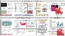
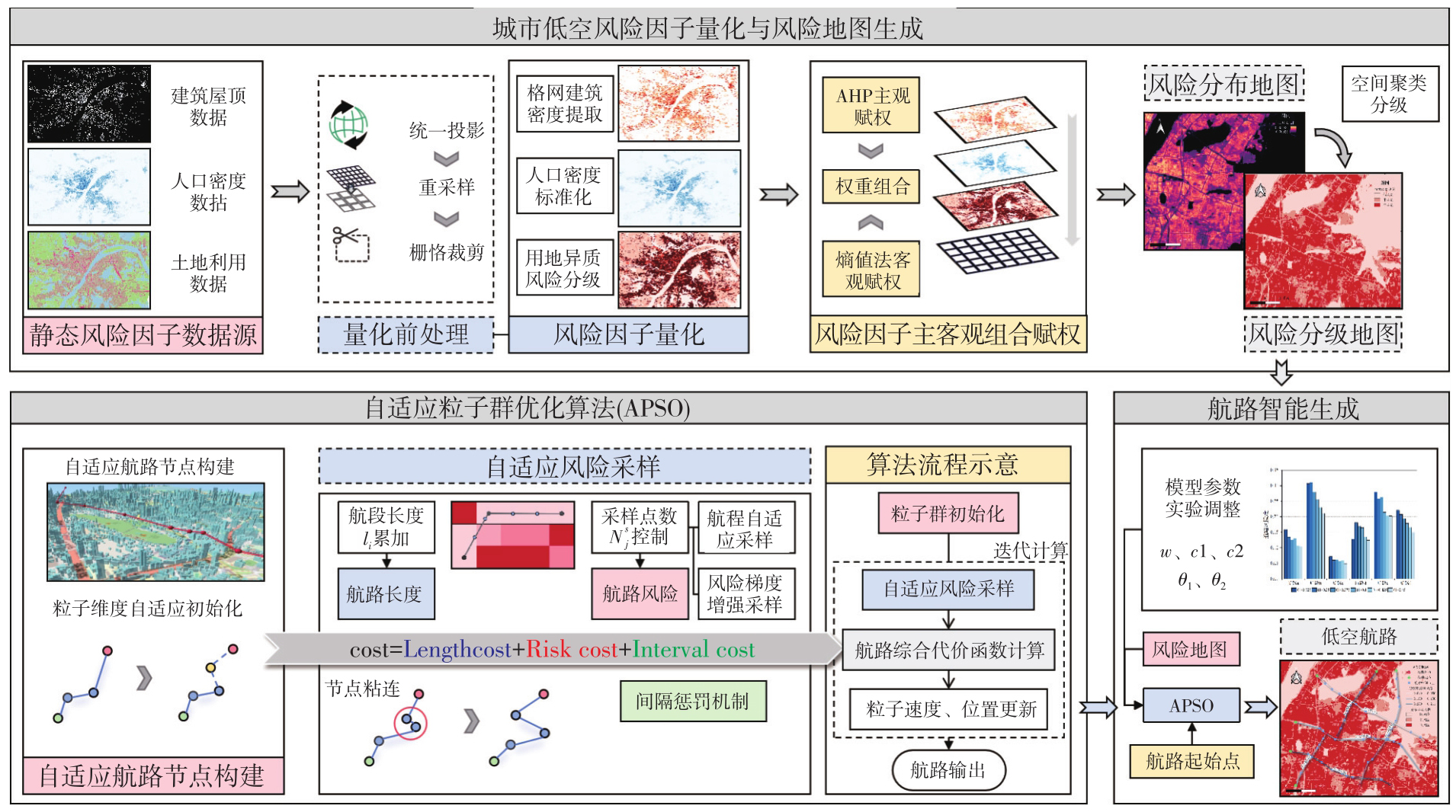
Fig. 1
The overall modeling framework"

Tab. 1
Quantitative standard of low-altitude risk corresponding to land use type"
| 风险度 | 风险区域 | 风险类型 | 用地分类 |
|---|---|---|---|
| 0.85 | 建筑 | 硬性聚集风险 | H-建设用地、R-居住用地、A-公共管理与公共服务用地、B-商业服务业设施用地、M-工业用地、W-物流仓储用地 |
| 0.50 | 道路 | 动态损失风险 | S-道路与交通设施用地 |
| 0.25 | 植被 | 柔性缓冲风险 | G-绿地与广场用地、E-非建设用地 |
| 0.10 | 水域 | E-非建设用地(E1水域) |
Tab. 2
AHP weighting results"
| 风险因子 | 特征向量 | 权重值/(%) | 最大特征根 | CR值 |
|---|---|---|---|---|
| 人口密度 | 1.471 | 49.048 | 3.054 | 0.027 |
| 建筑密度 | 0.593 | 19.762 | ||
| 土地覆盖 | 0.936 | 31.190 |
Tab. 3
Risk factor portfolio weight"
| 风险因子 | AHP权重 | 熵值法权重 | 组合权重 |
|---|---|---|---|
| 人口 | 0.490 | 0.395 | 0.44 |
| 建筑 | 0.198 | 0.418 | 0.31 |
| 土地 | 0.312 | 0.188 | 0.25 |
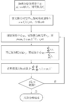
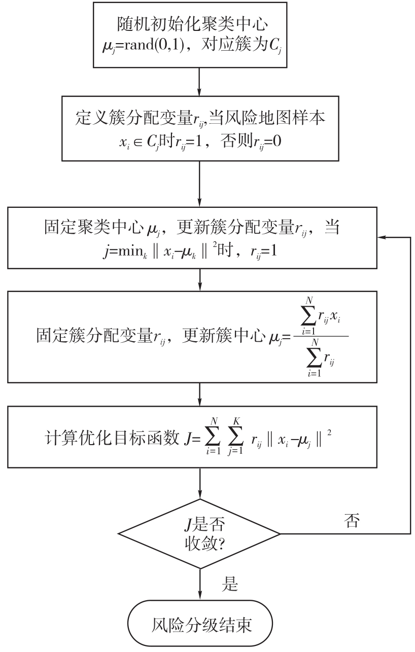
Fig. 2
Risk classification of low-altitude risk distribution map using K-Means clustering algorithm"
Tab. 4
Risk classification threshold"
| 风险级别 | 聚类中心 | 风险值下界 | 风险值上界 |
|---|---|---|---|
| 低风险 | 0.024 0 | 0.000 0 | 0.184 1 |
| 中风险 | 0.344 1 | 0.184 1 | 0.446 1 |
| 高风险 | 0.548 1 | 0.446 1 | 1.000 0 |
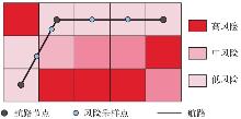
Fig. 3
Risk map sampling"
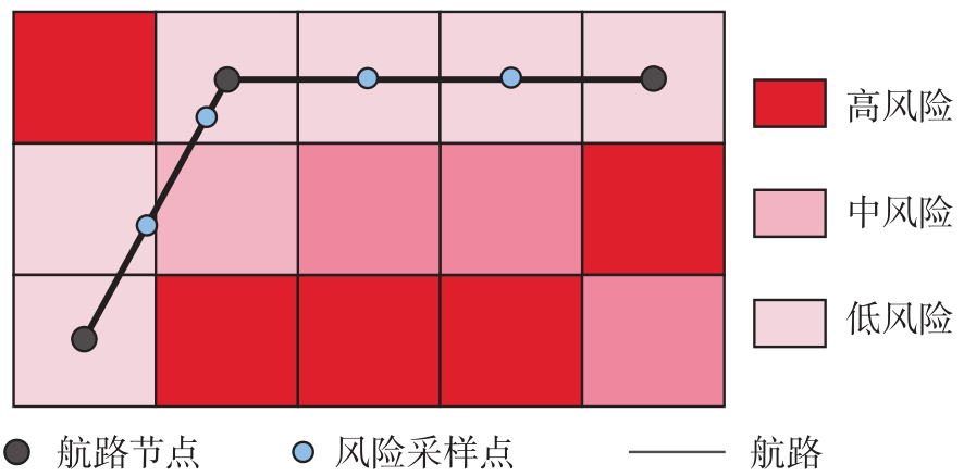
Fig. 4
Flowchart of APSO-AR"
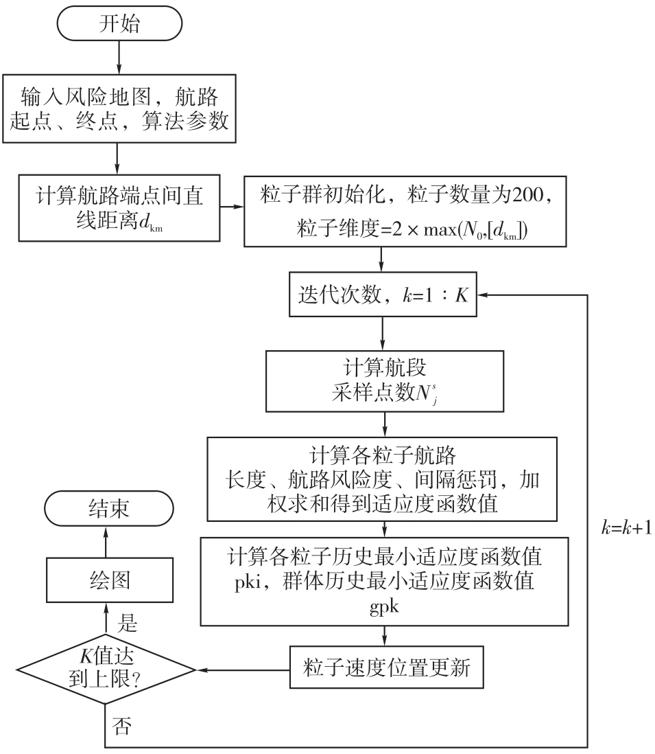
Fig. 5
Overview of route generation area"
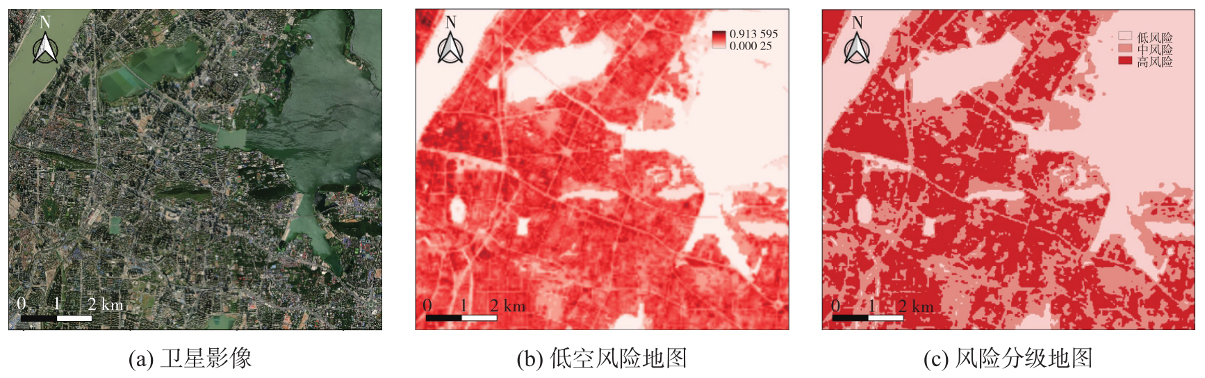
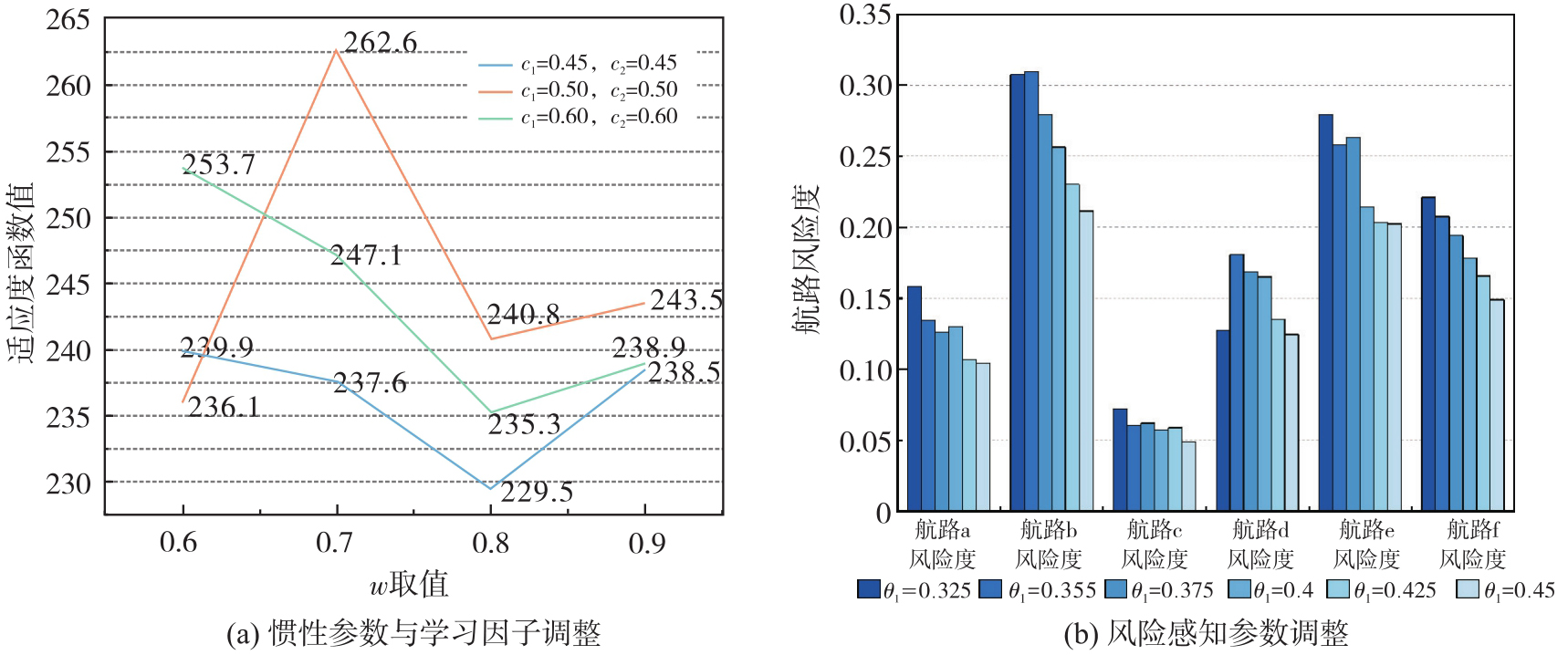
Fig. 6
Model parameters setting"
Tab. 5
Route endpoint and risk situation"
| 航路名称 | 起点 | 终点 | APSO-AR生成航路情况 | ||||
|---|---|---|---|---|---|---|---|
| 像素坐标 | 地理坐标 | 像素坐标 | 地理坐标 | 航路综合代价 | 航路长度/m | 风险度 | |
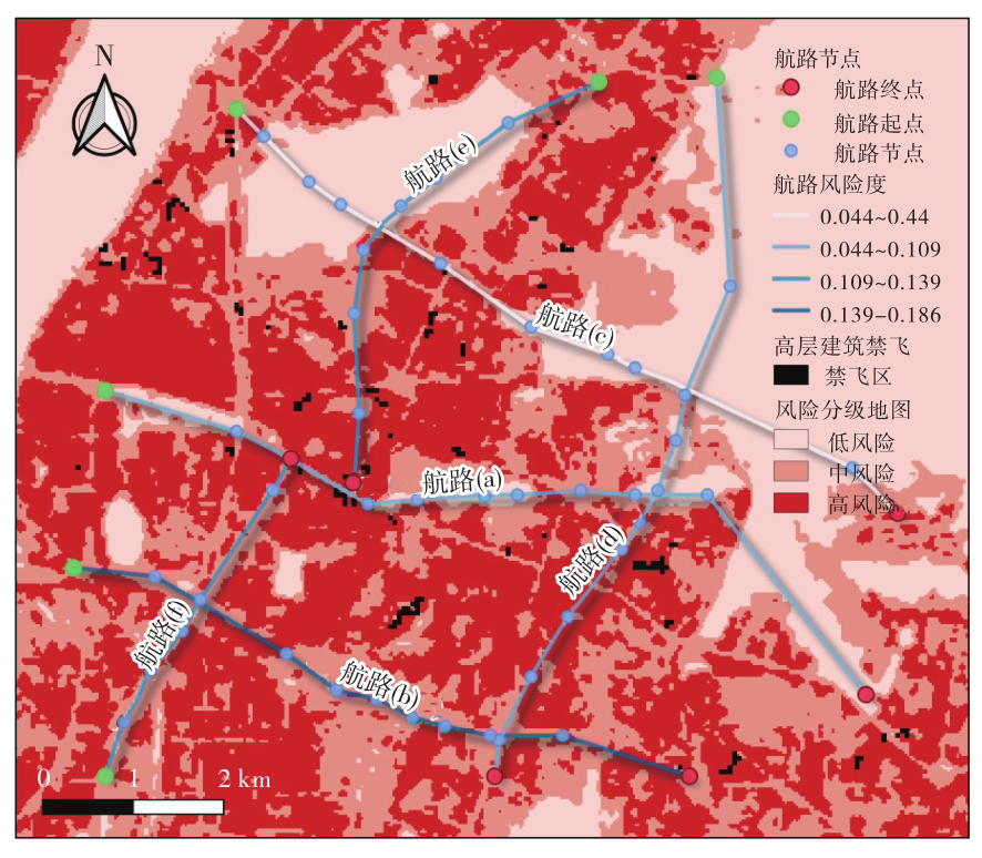
| 航路a | (85,7) | 30.546°N,114.298°E | (18,175) | 30.519°N,114.382°E | 96.94 | 9 767.02 | 0.084 |
| 航路b | (46,0) | 30.528°N,114.294°E | (0,136) | 30.508°N,114.363°E | 81.00 | 7 336.45 | 0.186 |
| 航路c | (147,36) | 30.576°N,114.312°E | (58,182) | 30.533°N,114.389°E | 82.00 | 8 647.15 | 0.044 |
| 航路d | (0,93) | 30.508°N,114.341°E | (154,142) | 30.577°N,114.367°E | 85.44 | 8 379.25 | 0.109 |
| 航路e | (153,116) | 30.576°N,114.354°E | (65,62) | 30.536°N,114.325°E | 60.92 | 5 786.55 | 0.139 |
| 航路f | (0,7) | 30.508°N,114.297°E | (70,48) | 30.539°N,114.319°E | 42.65 | 4 070.69 | 0.134 |
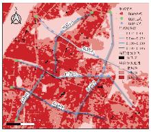
Fig. 7
Low-altitude route generated by APSO-AR"
Tab. 6
Performances of different route planning algorithms"
| 模型 | 航路综合代价 | 航路长度/m | 航路风险度 | 收敛代数 | 运行时长/s | 风险等级 |
|---|---|---|---|---|---|---|
| risk A* | 92.414 | 8247 | 0.206 | — | 0.227 | 中 |
| PSO | 85.274 | 7895 | 0.167 | 207 | 63.299 | 低 |
| GA | 91.842 | 8228 | 0.189 | 540 | 38.447 | 中 |
| ACO | 96.297 | 8882 | 0.173 | 238 | 245.386 | 低 |
| APSO-AR | 75.593 | 7318 | 0.128 | 112 | 19.605 | 低 |
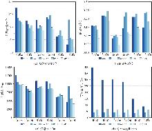
Fig. 8
Comprehensive performances comparison of different route planning algorithoms"
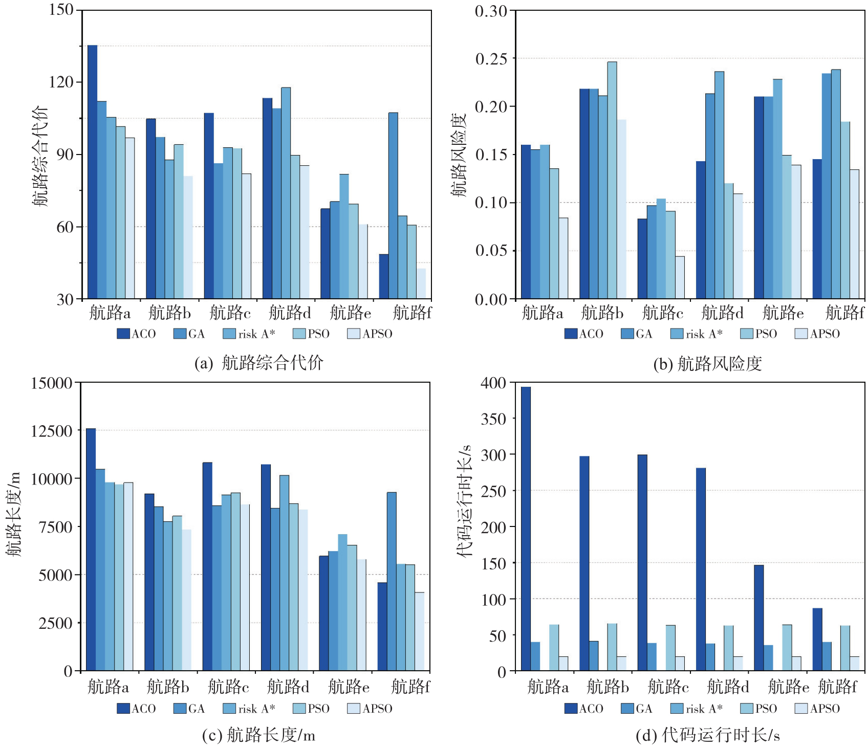
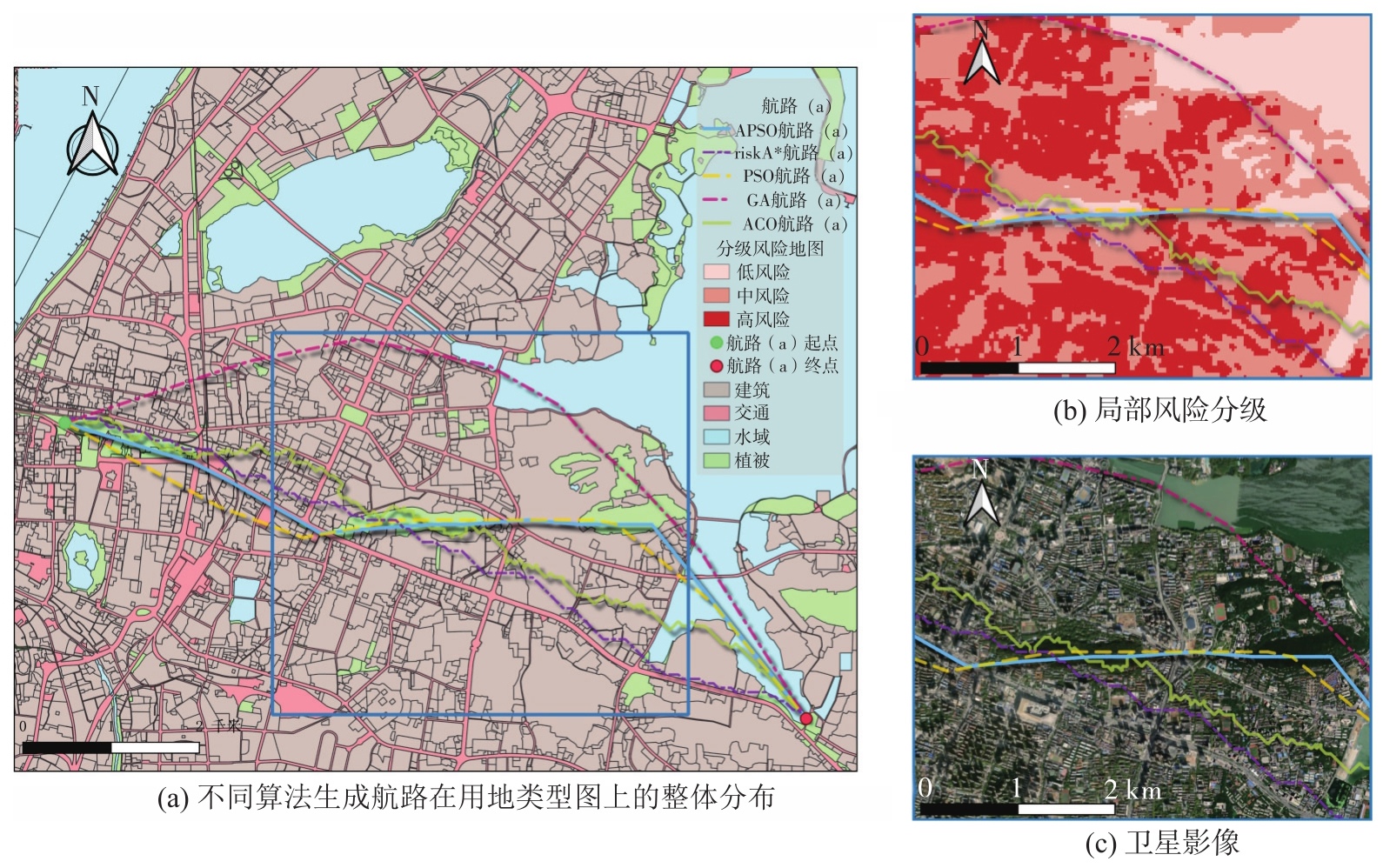
Fig. 9
Spatial distribution and ground-risk avoidance comparison of routes generated by different algorithms"
| [1] | 唐炉亮, 齐恒, 施泓羽, 等. 低空航路地图:支撑低空经济规模化飞行安全的公共基础设施[J]. 科学通报, 2026, 71(13): 2919-2932. |
| Tang Luliang, Qi Heng, Shi Hongyu, et al. Low-altitude sky-lane map: a new infrastructure of the high-density flying safety for low-altitude economy[J]. Science Bulletin, 2026, 71(13): 2919-2932. | |
| [2] | 李晓华. 我国低空消费的发展现状与前景[J]. 人民论坛, 2026(2): 74-78. |
| Li Xiaohua. Current status and prospects of low-altitude consumption in China[J]. People's Tribune, 2026(2): 74-78. | |
| [3] | 廖小罕, 屈文秋, 徐晨晨, 等. 城市空中交通及其新型基础设施低空公共航路研究综述[J]. 航空学报, 2023, 44(24): 1-29. |
| Liao Xiaohan, Qu Wenqiu, Xu Chenchen, et al. A review of urban air mobility and its new infrastructure low-altitude public routes[J]. Acta Aeronautica et Astronautica Sinica, 2023, 44(24): 1-29. | |
| [4] | 晏磊, 廖小罕, 周成虎, 等. 中国无人机遥感技术突破与产业发展综述[J]. 地球信息科学学报, 2019, 21(4): 475-495. |
| Yan Lei, Liao Xiaohan, Zhou Chenghu, et al. The impact of UAV remote sensing technology on the industrial development of China: a review[J]. Journal of Geo-Information Science, 2019, 21(4): 475-495. | |
| [5] | 贾永楠. 低空空域无人系统交通管理方案初探[J]. 航空学报, 2025, 46(11): 114-140. |
| Jia Yongnan. A scheme for unmanned aerial system traffic management in low-altitude airspace[J]. Acta Aeronautica et Astronautica Sinica, 2025, 46(11): 114-140. | |
| [6] | 全权, 李刚, 柏艺琴, 等. 低空无人机交通管理概览与建议[J]. 航空学报, 2020, 41(1): 023238. |
| Quan Quan, Li Gang, Bai Yiqin, et al. Low altitude UAV traffic management: an introductory overview and proposal[J]. Acta Aeronautica et Astronautica Sinica, 2020, 41(1): 023238. | |
| [7] | 徐晨晨, 叶虎平, 岳焕印, 等. 城镇化区域无人机低空航路网迭代构建的理论体系与技术路径[J]. 地理学报, 2020, 75(5): 917-930. |
| Xu Chenchen, Ye Huping, Yue Huanyin, et al. Iterative construction of UAV low-altitude air route network in an urbanized region: theoretical system and technical roadmap[J]. Acta Geographica Sinica, 2020, 75(5): 917-930. | |
| [8] | 张洪海, 李姗, 夷珈, 等. 城市低空航路规划研究综述[J]. 南京航空航天大学学报, 2021, 53(6): 827-838. |
| Zhang Honghai, Li Shan, Yi Jia, et al. Review on urban low-altitude air route planning[J]. Journal of Nanjing University of Aeronautics & Astronautics, 2021, 53(6): 827-838. | |
| [9] | 廖小罕, 徐晨晨, 叶虎平. 低空经济发展与低空路网基础设施建设的效益和挑战[J]. 中国科学院院刊, 2024, 39(11): 1966-1981. |
| Liao Xiaohan, Xu Chenchen, Ye Huping. Benefits and challenges of constructing low-altitude air route network infrastructure for developing low-altitude economy[J]. Bulletin of Chinese Academy of Sciences, 2024, 39(11): 1966-1981. | |
| [10] | La Cour-Harbo A. Quantifying risk of ground impact fatalities for small unmanned aircraft[J]. Journal of Intelligent & Robotic Systems, 2019, 93(1): 367-384. |
| [11] | 郑秀梅, 李智恒. 城市空中交通感知风险识别与评价:基于在线评论数据[J]. 安全与环境学报, 2025, 25(8): 3143-3150. |
| Zheng Xiumei, Li Zhiheng. Identification and assessment of perceived risks in UAM based on online review data[J]. Journal of Safety and Environment, 2025, 25(8): 3143-3150. | |
| [12] | Sunil E, Ellerbroek J, Hoekstra J, et al. Analysis of airspace structure and capacity for decentralized separation using fast-time simulations[J]. Journal of Guidance, Control, and Dynamics, 2017, 40(1): 38-51. |
| [13] | He Xinyu, Li Lishuai, Mo Yanfang, et al. Air corridor planning for urban drone delivery: complexity analysis and comparison via multi-commodity network flow and graph search[J]. Transportation Research Part E: Logistics and Transportation Review, 2025, 193: 103859. |
| [14] | Primatesta S, Rizzo A, La Cour-Harbo A. Ground risk map for unmanned aircraft in urban environments[J]. Journal of Intelligent & Robotic Systems, 2020, 97(3): 489-509. |
| [15] | 胡莘婷, 戴福青. 基于城区行人安全的无人机运行风险评估[J]. 中国安全科学学报, 2020, 30(8): 137-142. |
| Hu Xinting, Dai Fuqing. Risk assessment model for UAV operation considering safety of ground pedestrians in urban areas[J]. China Safety Science Journal, 2020, 30(8): 137-142. | |
| [16] | 王文涛, 甘旭升, 吴亚荣, 等. 考虑不确定性的低空无人机运行风险评估方法[J]. 现代防御技术, 2022, 50(5): 14-21. |
| Wang Wentao, Gan Xusheng, Wu Yarong, et al. Low-altitude UAV operation risk assessment method considering the uncertainty[J]. Modern Defense Technology, 2022, 50(5): 14-21. | |
| [17] | Zhang Honghai, Zou Yiyuan, Wang Zhongye, et al. Assessment model of safety situation in low-altitude airspace based on AGA-FCM[C]//Proceedings of 4th International Conference on Electromechanical Control Technology and Transportation (ICECTT). Guilin: IEEE, 2019: 10-17. |
| [18] | Zhao Zhenyu, Zhang Lanfang, Zhou Ruida, et al. A flight risk field model for advanced low-altitude transportation system using field theory[J]. Transportation Research Part A: Policy and Practice, 2024, 190: 104268. |
| [19] | Levitt I, Phojanamongkolkij N, Horn A, et al. UAM airspace research roadmap-Rev.2.0[R/OL]. (2023-03-01) [2025-04-09]. https://ntrs.nasa.gov/citations/20230002647. |
| [20] | McFadyen A, Bruggemann T. Unmanned air traffic network design concepts[C]//Proceedings of 2017 IEEE International Conference on Intelligent Transportation Systems. Yokohama: IEEE, 2017: 1-7. |
| [21] | Fu Yangguang, Ding Mingyue, Zhou Chengping, et al. Route planning for unmanned aerial vehicle (UAV) on the sea using hybrid differential evolution and quantum-behaved particle swarm optimization[J]. IEEE Transactions on Systems, Man, and Cybernetics: Systems, 2013, 43(6): 1451-1465. |
| [22] | Gharibi M, Boutaba R, Waslander S L. Internet of drones[J]. IEEE Access, 2016, 4: 1148-1162. |
| [23] | 张海阔, 孟秀云. 基于改进粒子群算法的无人机航迹规划[J]. 飞行力学, 2024, 42(2): 29-35. |
| Zhang Haikuo, Meng Xiuyun. UAV route planning based on improved particle swarm optimization algorithm[J]. Flight Dynamics, 2024, 42(2): 29-35. | |
| [24] | Zhao Pengfei. Optimization of LSTM ship trajectory prediction based on hybrid genetic algorithm[J]. Journal of Geodesy and Geoinformation Science, 2024, 7(3): 89-102. |
| [25] | 徐晨晨, 廖小罕, 岳焕印, 等. 基于改进蚁群算法的无人机低空公共航路构建方法[J]. 地球信息科学学报, 2019, 21(4): 570-579. |
| Xu Chenchen, Liao Xiaohan, Yue Huanyin, et al. Construction of a UAV low-altitude public air route based on an improved ant colony algorithm[J]. Journal of Geo-Information Science, 2019, 21(4): 570-579. | |
| [26] | 李士途, 姜灵芝. 基于A*算法的无人机智能避障路径及实时航路规划研究[J]. 自动化与仪器仪表, 2024(12): 67-71. |
| Li Shitu, Jiang Lingzhi. Intelligent obstacle avoidance path and real-time navigation route planning of UAV based on A* algorithm[J]. Automation & Instrumentation, 2024(12): 67-71. | |
| [27] | Rudnick-Cohen E, Herrmann J W, Azarm S. Risk-based path planning optimization methods for unmanned aerial vehicles over inhabited Areas1[J]. Journal of Computing and Information Science in Engineering, 2016, 16(2): 021004. |
| [28] | 张宏宏, 甘旭升, 李双峰, 等. 复杂低空环境下考虑区域风险评估的无人机航路规划[J]. 仪器仪表学报, 2021, 42(1): 257-266. |
| Zhang Honghong, Gan Xusheng, Li Shuangfeng, et al. UAV route planning considering regional risk assessment under complex low altitude environment[J]. Chinese Journal of Scientific Instrument, 2021, 42(1): 257-266. | |
| [29] | Primatesta S, Guglieri G, Rizzo A. A risk-aware path planning strategy for UAVs in urban environments[J]. Journal of Intelligent & Robotic Systems, 2019, 95(2): 629-643. |
| [30] |
张瑞鑫, 徐青, 吕峥, 等. 基于高斯混合回归与改进A*算法的时间最优路径规划方法[J]. 测绘学报, 2025, 54(6): 1139-1151. DOI: .
doi: 10.11947/j.AGCS.2025.20240478 |
|
Zhang Ruixin, Xu Qing, Lü Zheng, et al. Time optimal path planning method based on Gaussian mixture regression and improved A* algorithm[J]. Acta Geodaetica et Cartographica Sinica, 2025, 54(6): 1139-1151. DOI: .
doi: 10.11947/j.AGCS.2025,20240478 |
|
| [31] | Washington A, Clothier R A, Silva J. A review of unmanned aircraft system ground risk models[J]. Progress in Aerospace Sciences, 2017, 95: 24-44. |
| [32] | Dobson J E, Bright E A, Coleman P R, et al. LandScan: a global population database for estimating populations at risk[J]. Photogrammetric Engineering and Remote Sensing, 66(7): 849-857. |
| [33] | Batista e Silva F, Freire S, Schiavina M, et al. Uncovering temporal changes in Europe's population density patterns using a data fusion approach[J]. Nature Communications, 2020, 11: 4631. |
| [34] | Deville P, Linard C, Martin S, et al. Dynamic population mapping using mobile phone data[J]. Proceedings of the National Academy of Sciences of the United States of America, 2014, 111(45): 15888-15893. |
| [35] | GB 50137—2011城市用地分类与规划建设用地标准[S]. |
| GB 50137—2011 Code for classification of urban land use and planning standards of development land[S]. | |
| [36] | 高玉琴, 王慧, 刘钺, 等. 基于空间信息格网的南京市洪水风险评估[J]. 水利水电科技进展, 2024, 44(6): 6-12. |
| Gao Yuqin, Wang Hui, Liu Yue, et al. Flood disaster risk assessment in Nanjing city based on spatial information grids[J]. Advances in Science and Technology of Water Resources, 2024, 44(6): 6-12. | |
| [37] | 郭金玉, 张忠彬, 孙庆云. 层次分析法的研究与应用[J]. 中国安全科学学报, 2008, 18(5): 148-153. |
| Guo Jinyu, Zhang Zhongbin, Sun Qingyun. Study and applications of analytic hierarchy process[J]. China Safety Science Journal, 2008, 18(5): 148-153. | |
| [38] | Sinaga K P, Yang M S. Unsupervised K-means clustering algorithm[J]. IEEE Access, 2020, 8: 80716-80727. |
| [39] | 冯茜, 李擎, 全威, 等. 多目标粒子群优化算法研究综述[J]. 工程科学学报, 2021, 43(6): 745-753. |
| Feng Qian, Li Qing, Quan Wei, et al. Overview of multiobjective particle swarm optimization algorithm[J]. Chinese Journal of Engineering, 2021, 43(6): 745-753. | |
| [40] | Dorigo M, Maniezzo V, Colorni A. Ant system: optimization by a colony of cooperating agents[J]. IEEE Transactions on Systems, Man, and Cybernetics, Part B (Cybernetics), 1996, 26(1): 29-41. |
| [41] | 范洪达, 叶文, 马向玲. 基于遗传算法的飞机低空突防航路规划[J]. 航空计算技术, 2003, 33(1): 13-17. |
| Fan Hongda, Ye Wen, Ma Xiangling. Low altitude penetration route planning of the plane based on genetic algorithm[J]. Aeronautical Computer Technique, 2003, 33(1): 13-17. | |
| [42] | Ramírez-Ochoa D D, Pérez-Domínguez L A, Martínez-Gómez E A, et al. PSO, a swarm intelligence-based evolutionary algorithm as a decision-making strategy: a review[J]. Symmetry, 2022, 14(3): 455. |
| [43] | 武汉市人民政府门户网站. 市人民政府关于印发武汉市支持低空经济高质量发展若干措施的通知[EB/OL]. [2025-08-29]. https://www.wuhan.gov.cn/zwgk/xxgk/zfwj/gfxwj/202406/t20240607_2413516.shtml. |
| Wuhan Municipal People's Government. Notice of the Wuhan Municipal People's Government on Issuing Several Measures to Support the High-quality Development of the Low-altitude Economy in Wuhan[EB/OL]. [2025-08-29]. https://www.wuhan.gov.cn/zwgk/xxgk/zfwj/gfxwj/202406/t20240607_2413516.shtml. | |
| [44] | Chen Yuehong, Xu Congcong, Ge Yong, et al. A 100 m gridded population dataset of China's seventh census using ensemble learning and big geospatial data[J]. Earth System Science Data, 2024, 16(8): 3705-3718. |
| [45] | Liu Zeping, Tang Hong, Feng Lin, et al. CBRA: The first multi-annual (2016-2021) and high-resolution (2.5 m) building rooftop area dataset in China derived with Super-resolution Segmentation from Sentinel-2 imagery[DS/OL]. [2025-08-28]. https://zenodo.org/records/7500612. |
| [46] | Aleti A, Moser I. A systematic literature review of adaptive parameter control methods for evolutionary algorithms[J]. ACM Computing Surveys, 2016, 49(3): 1-35. |
| [47] | Trelea I C. The particle swarm optimization algorithm: convergence analysis and parameter selection[J]. Information Processing Letters, 2003, 85(6): 317-325. |
| [1] | Qinghua GUO, Zekun YANG, Zhiyong QI, Yixuan ZHANG, Zhixin CHENG, Kang LIU, Kai CHENG, Ang CHEN, Luyi YANG. Geospatial information empowering the low-altitude economy: key technological breakthroughs and industrial development [J]. Acta Geodaetica et Cartographica Sinica, 2026, 55(6): 975-989. |
| [2] | Bisheng YANG, You LI, Chi CHEN. Autonomous surveying and mapping for shaping the foundation of low-altitude economy [J]. Acta Geodaetica et Cartographica Sinica, 2026, 55(6): 961-974. |
| [3] | Han WANG, Yun XIAO, Huaikui GUAN, Weixuan SUN. An improved Butterworth gravity downward continuation method driven by entropy-PSO dual optimization [J]. Acta Geodaetica et Cartographica Sinica, 2025, 54(9): 1620-1632. |
| [4] | Zhaoying WANG, Hongzhou CHAI, Zhenqiang DU. Hierarchical modeling of sound velocity field based on improved BPNN [J]. Acta Geodaetica et Cartographica Sinica, 2024, 53(12): 2316-2327. |
| [5] | . Remote Sensing Image Change Detection Using Particle Swarm Optimization Algorithm [J]. Acta Geodaetica et Cartographica Sinica, 2012, 41(6): 857-863. |
| Viewed | ||||||
|
Full text |
|
|||||
|
Abstract |
|
|||||
