


测绘学报 ›› 2024, Vol. 53 ›› Issue (6): 1165-1179.doi: 10.11947/j.AGCS.2024.20230469
顾海燕1,2( ), 杨懿1,2, 李海涛1,2(), 孙立坚1,2, 丁少鹏1,2, 刘世琦1,2
收稿日期:2023-10-11
发布日期:2024-07-22
通讯作者:
李海涛
E-mail:guhy@casm.ac.cn;lhtao@casm.ac.cn
作者简介:顾海燕(1982—),女,博士,研究员,研究方向为遥感影像智能解译与高性能计算。 E-mail:guhy@casm.ac.cn
基金资助:
Haiyan GU1,2(), Yi YANG1,2, Haitao LI1,2(), Lijian SUN1,2, Shaopeng DING1,2, Shiqi LIU1,2
Received:2023-10-11
Published:2024-07-22
Contact:
Haitao LI
E-mail:guhy@casm.ac.cn;lhtao@casm.ac.cn
About author:GU Haiyan (1982—), female, PhD, researcher, majors in intelligent interpretation and high-performance computing of remote sensing images. E-mail: guhy@casm.ac.cn
Supported by:摘要:
在人工智能时代,遥感影像解译朝着自动化智能化方向发展,高质量的样本数据集是其核心。我国积累了海量优质的时空地理信息基础数据及衍生产品,是深度学习驱动的遥感影像智能解译样本的重要来源。盘活现有数据资源,可推动人工智能与遥感解译的应用深度与广度。本文基于现有数据资源,针对样本数据集区域受限、时效性不强、类型单一等问题,研究了面向深度学习的高分遥感影像智能解译样本库动态构建技术。首先,分析了要素提取、地表覆盖分类、变化检测方面的公开样本数据集的特点,提出业务驱动的样本应需生成-动态构建-智能应用思路;其次,研究了基于历史解译成果的样本自动生成、SAM大模型提示学习引导的样本清洗精化方法及实现过程;再次,设计了具有区域性、时序性、尺度性、多传感器、多类型的样本库,以及顾及空间-时间-地类关系的动态样本数据库架构,研究了样本数据集“量化-检索-组合”动态重构过程,实现时空样本的动态管理与多维检索;最后,开展了地表覆盖分类、要素提取、变化检测等智能解译应用,验证了本文研究思路及方法的可行性,以期推动基于已有基础数据的样本数据集的有效利用,以及样本构建-管理-应用及数据-模型-业务的互联互通,为高分遥感影像智能解译样本库构建与应用提供参考思路。
中图分类号:
顾海燕, 杨懿, 李海涛, 孙立坚, 丁少鹏, 刘世琦. 高分辨率遥感影像样本库动态构建与智能解译应用[J]. 测绘学报, 2024, 53(6): 1165-1179.
Haiyan GU, Yi YANG, Haitao LI, Lijian SUN, Shaopeng DING, Shiqi LIU. Dynamic construction of high-resolution remote sensing image sample datasets and intelligent interpretation applications[J]. Acta Geodaetica et Cartographica Sinica, 2024, 53(6): 1165-1179.
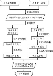
图1
基于历史解译成果的样本自动生成流程"
表1
编码转换"
| 地理国情信息分类码 | 深度学习的自定义编码 | ||||
|---|---|---|---|---|---|
| 代码 | 一级 | 二级 | 三级 | 代码 | 类别 |
| 100 | 种植土地 | 1 | 水田 | ||
| 110 | 水田 | 1 | |||
| 120 | 旱地 | 2 | 旱地 | ||
| 130 | 果园 | 3 | 园地 | ||
| 131 | 乔灌果园 | 3 | |||
| 132 | 藤本果园 | 3 | |||
| 133 | 草本果园 | 3 | |||
| 140 | 茶园 | 3 | |||
| 150 | 桑园 | 3 | |||
| 160 | 橡胶园 | 3 | |||
| 170 | 苗圃 | 3 | |||
| 180 | 花圃 | 3 | |||
| 190 | 其他经济苗木 | 3 | |||
| 191 | 其他乔灌经济苗木 | 3 | |||
| 192 | 其他藤本经济苗木 | 3 | |||
| 193 | 其他草本经济苗木 | 3 | |||
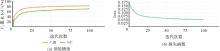
图2
精度指标一致性分析"

图3
自动生成样本示例"
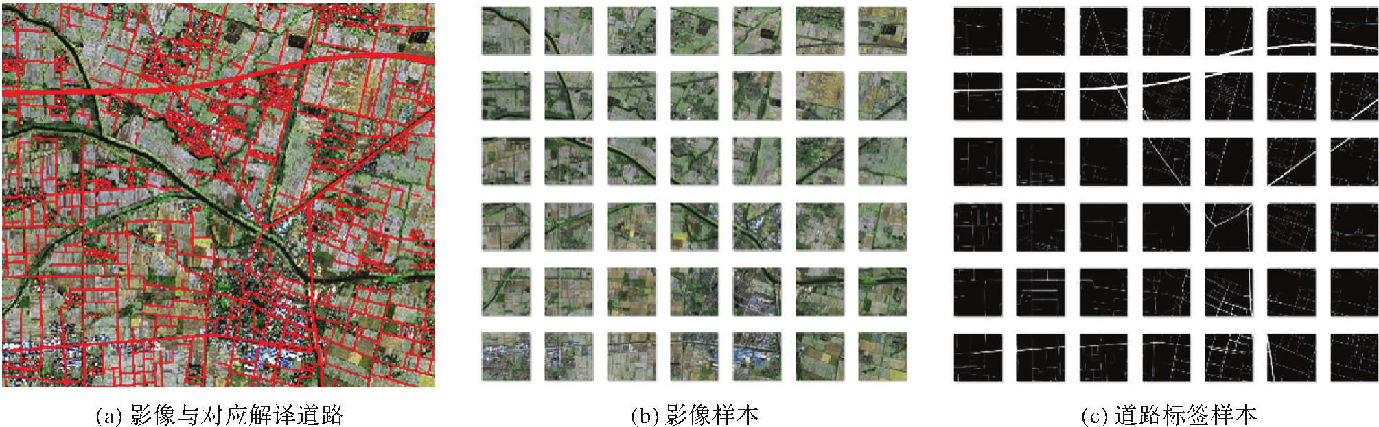

图4
样本清洗方法注:Fi为输入数据;Fie为强化输出数据;Q、K、V分别表示查询、键和值。"
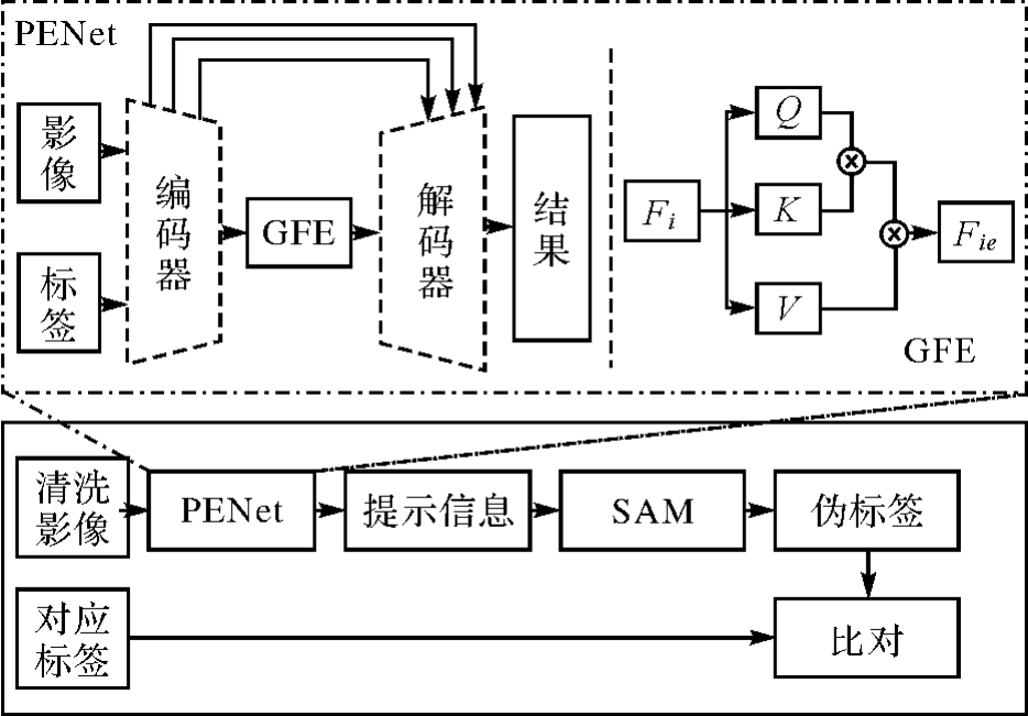
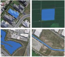
图5
SAM精化结果"
表2
时空样本数据集设计内容"
| 项目 | 内容 |
|---|---|
| 分区 | 东北、华北、华东、华中、华南、西南、西北 |
| 时相 | 覆盖全年多时相,主要考虑夏季和冬季两个差异度最大的时相,其中冬季时相的时间跨度设定为12月—次年3月,夏季时相的时间跨度设定为6—9月 |
| 地形地貌 | 平地、丘陵地、山地、高山地 |
| 影像类型 | 分辨率优于2 m的高分辨率遥感影像(如北京二号、高分一号、高分二号、资源三号等) |
| 数据集类型 | 要素提取、地表覆盖分类、变化检测 |
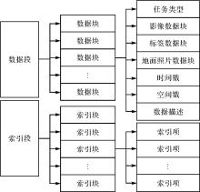
图6
动态样本数据库模型结构"


图7
样本数据集动态重构过程"
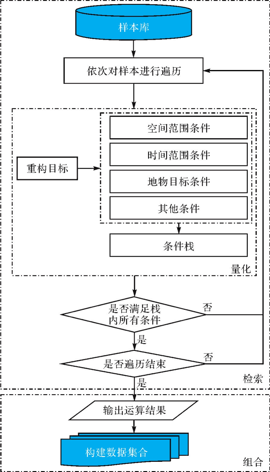

图8
样本库存储结构"
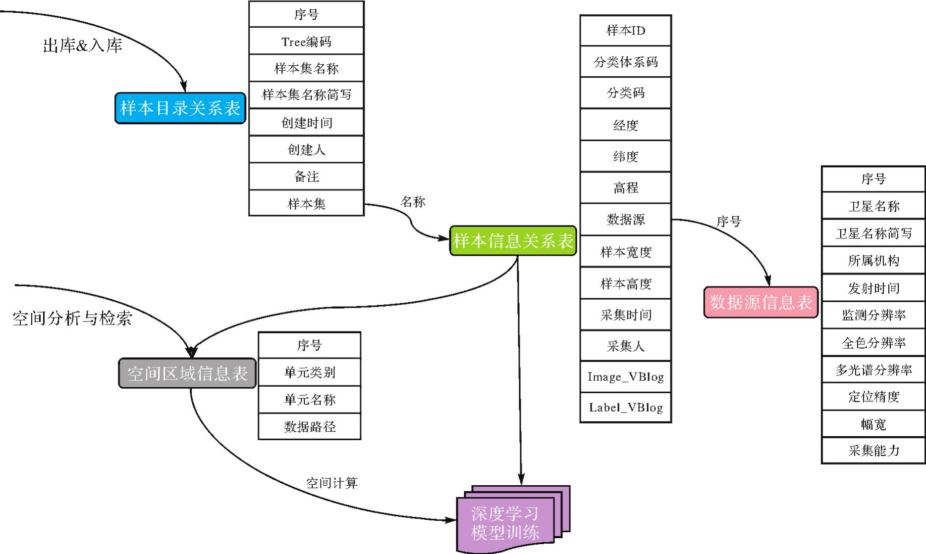
表3
样本目录关系"
| 序号 | 字段名 | 字段简写 | 字段含义 | 填写规则 | 填写方式 | 类型 | 示例 |
|---|---|---|---|---|---|---|---|
| 1 | FID | FID | 序号ID | 自增ID | 自动 | Int | 27 |
| 2 | TreeID | TreeID | Tree编码 | 样本的Tree编码,采用3位序列编码,同层最大编码不超过1000个节点 | 自动 | String | 003029 |
| 3 | SamSet Name | YBMC | 样本集名称 | 对应并总结概括样本集中样本内容 | 人工 | String | 内蒙古耕地 |
| 4 | SampSet Nano | YBJX | 样本集名称简写 | 样本集名称的简写形式 | 人工 | String | 蒙耕地 |
| 5 | SampSetDate | JCJSJ | 创建时间 | 采集时间 | 自动 | Date | 2022-08-30 |
| 6 | Creator | JCJR | 创建人 | 操作人员姓名 | 人工 | String | 张三 |
| 7 | SampBak | JBak | 备注 | 样本集的辅助性说明 | 人工 | String | 该样本集主要针对草原生态监测有关的科研样本 |
| 8 | SampSet Link | YBJ | 样本集 | 关联样本信息表 | 自动 | String | YB3715_2022 |
表4
样本信息关系"
| 序号 | 字段名 | 字段简写 | 字段含义 | 填写规则 | 填写方式 | 类型 | 示例 |
|---|---|---|---|---|---|---|---|
| 1 | FID | FID | 数据记录ID | 自增ID | 自动 | Int | 99 |
| 2 | SampleID | YBID | 样本ID | 样本唯一标识码:数据源_X_Y | 自动 | Int | GF1293_75 |
| 3 | Classification scheme | YBCS | 分类体系码 | — | 自动 | Int | 2 |
| 4 | Classification Code | CC | 分类码 | — | 自动 | Int | |
| 5 | Longitude | X | 经度 | 度(小数) | 自动 | Double | 118.653 498 7 |
| 6 | Latitude | Y | 纬度 | 度(小数) | 自动 | Double | 41.349 348 47 |
| 7 | Elevation | Z | 高程 | 整数(米) | 自动 | Double | 155 |
| 8 | DataSource | SJY | 数据源 | 数据源信息表中序号 | 自动 | Int | 14 |
| 9 | SampleWidth | YBKD | 样本宽度 | 样本宽度(像素) | 人工 | Int | 1024 |
| 10 | Sample Height | YBGD | 样本高度 | 样本高度(像素) | 人工 | Int | 1024 |
| 11 | SampleDate | CJSJ | 采集时间 | 采集时间 | 自动 | Date | 2021-08-30 |
| 12 | Operator | CJR | 采集人 | 人名 | 人工 | String | 张某 |
| 13 | Bak | Bak | 备注 | 辅助性说明 | 人工 | String | 钢架大棚房 |
| 14 | SampleImage | YBIM | 样本影像 | 大对象 | 自动 | Blob | |
| 15 | SampleLabel | YBLB | 样本标签 | 大对象 | 自动 | Blob |
表5
数据源信息"
| 序号 | 国产光学卫星名称 | 卫星名称简写 | 全色分辨率/m | 多光谱分辨率/m | 幅宽/km |
|---|---|---|---|---|---|
| 1 | 北京二号 | BJ2 | 0.8 | 3.2 | 24 |
| 2 | 高分一号 | GF1 | 2 | 8 | 35 |
| 3 | 高分二号 | GF2 | 0.8 | 3.2 | 45 |
| 4 | 高分六号 | GF6 | 2 | 8 | 90 |
| 5 | 资源三号 | ZY3 | 2.1 | 5.8 | 50 |
| 6 | 高景一号 | GJ1 | 0.5 | 2 | 12 |
表6
空间区域信息"
| 代码 | 地理单元类别 | 地理单元名称 | 数据路径 |
|---|---|---|---|
| 1 | 行政区域 | 全国行政区划单元(省域) | \a.shp |
| 2 | 行政区域 | 全国行政区划单元(地、市域) | \b.shp |
| 3 | 行政区域 | 全国行政区划单元(县域) | \c.shp |
| 4 | 格网 | 全国10 km地理格网单元 | \d.shp |
| 5 | 格网 | 全国5 km地理格网单元 | \e.shp |
| 6 | 格网 | 全国3 km地理格网单元 | \f.shp |
| 7 | 其他 | 其他,如地形地貌、流域、保护区、草原、粮食主产区、经济开发区等 | \** |
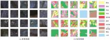
图9
地表覆盖分类样本示例"

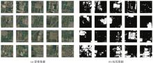
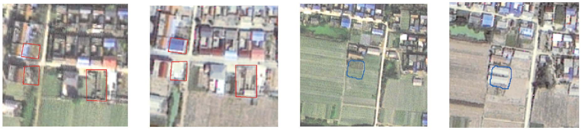
图10
单要素建筑物样本示例"
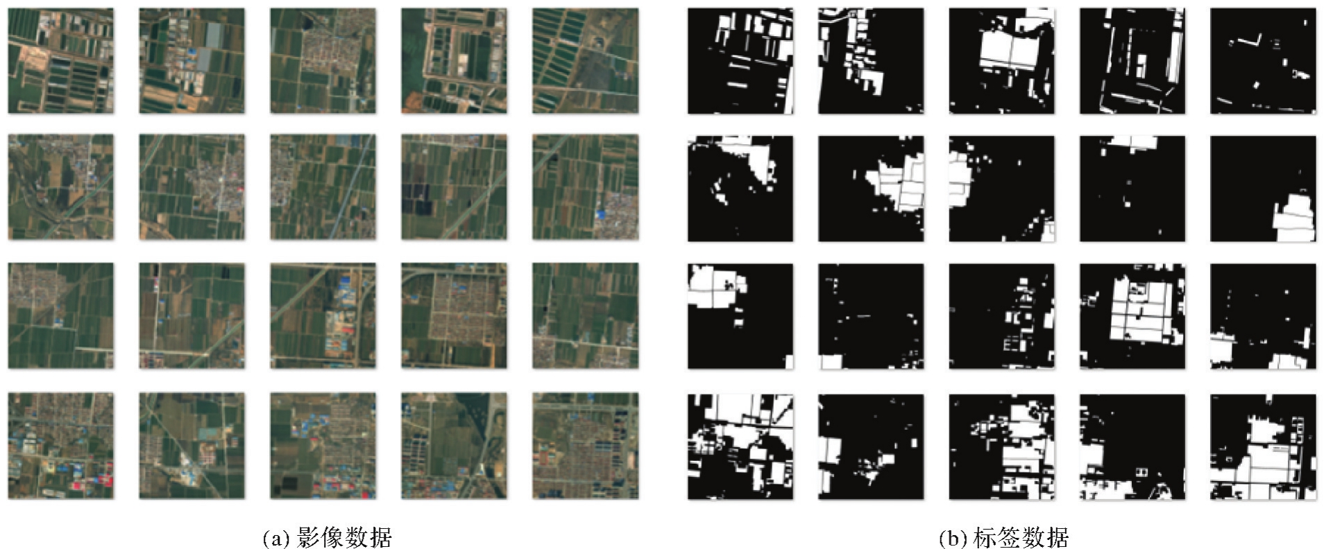
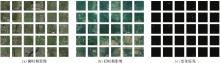
图11
变化检测样本示例"
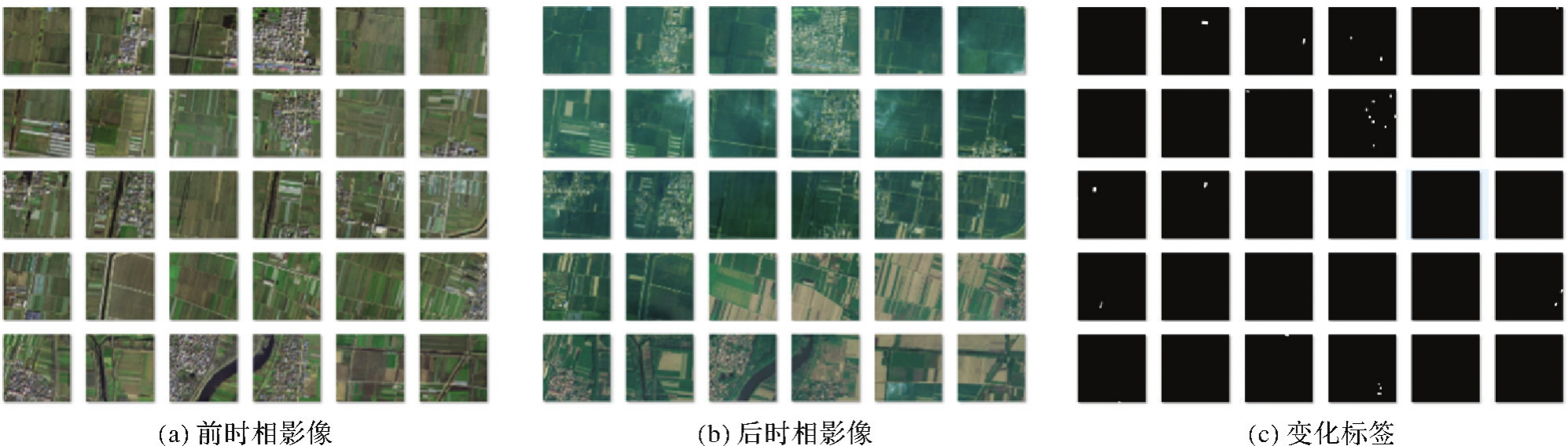

图12
地表覆盖分类结果"
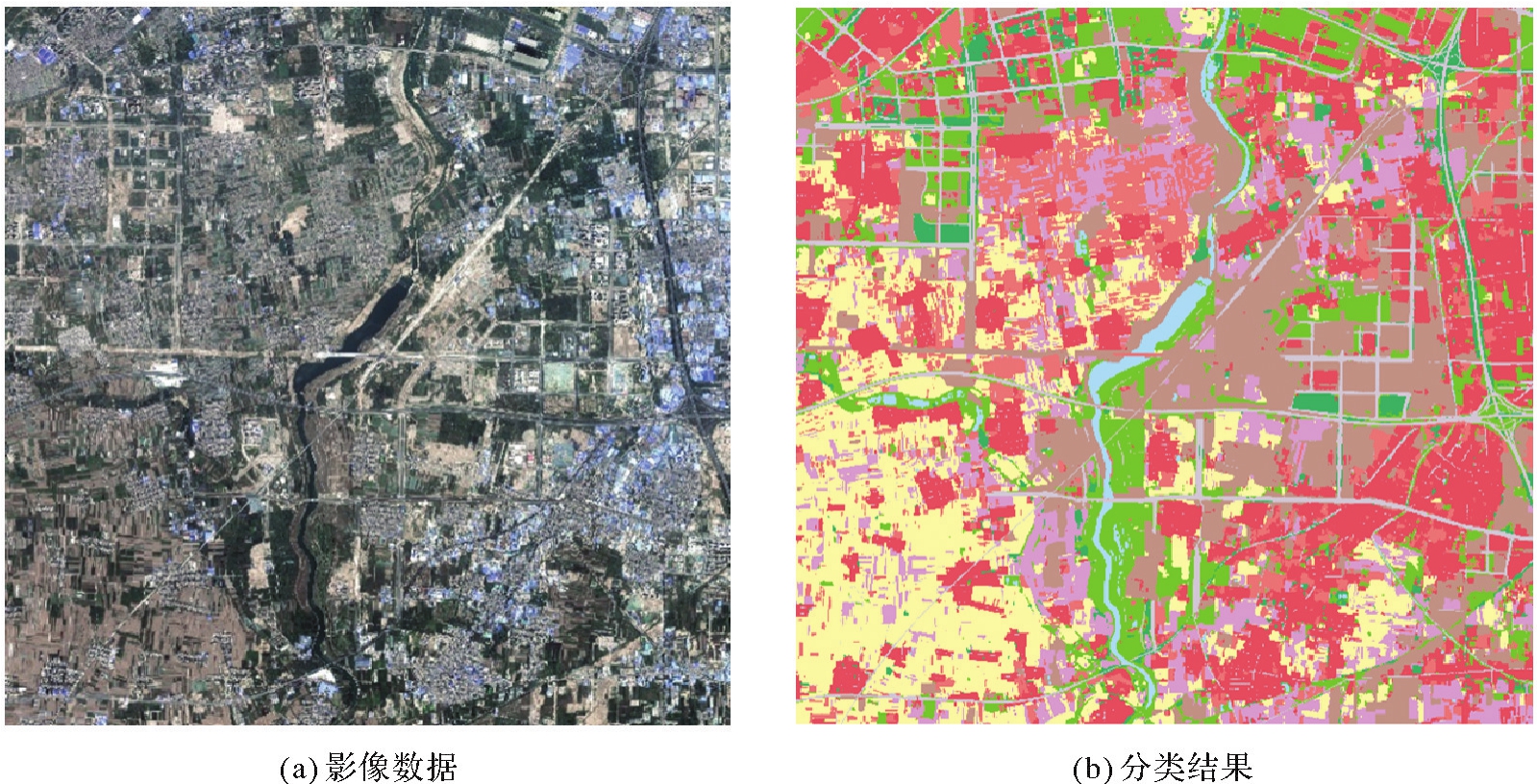
表7
地表覆盖分类精度"
| 指标 | 耕地 | 园地 | 林地 | 草地 | 建筑物 | 道路 | 构筑物 | 人工堆砌地 | 裸地 | 水域 | 平均 |
|---|---|---|---|---|---|---|---|---|---|---|---|
| OA | 88.95 | 81.0 | 60.49 | 83.53 | 91.0 | 67.88 | 72.21 | 88.97 | 71.04 | 75.26 | 78.03 |
| IoU | 78.41 | 68.23 | 51.16 | 66.72 | 78.4 | 56.92 | 63.08 | 79.84 | 64.63 | 68.39 | 67.58 |
图13
建筑物提取结果"
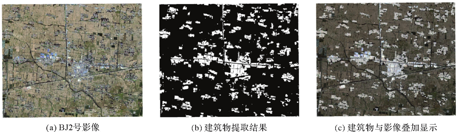
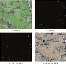
图14
建筑物变化检测结果"

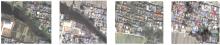
图15
局部变化结果"
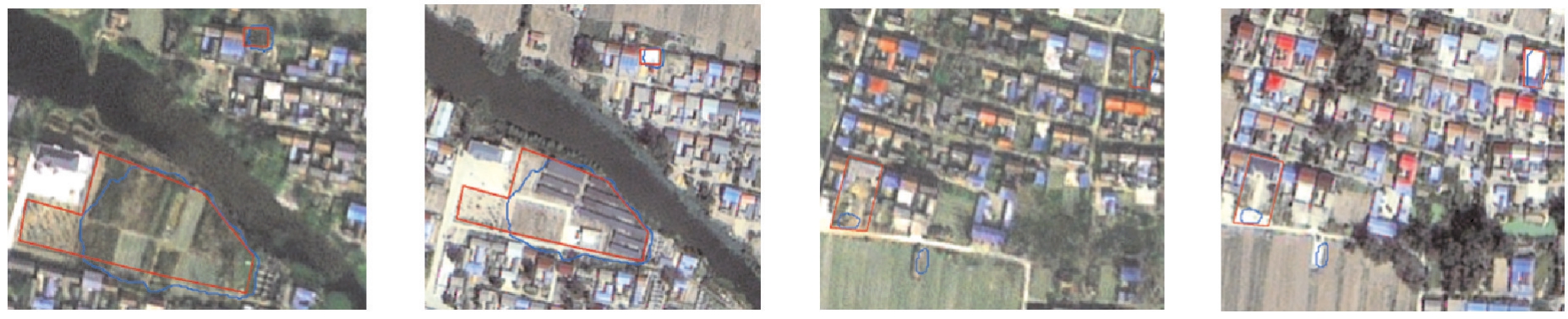

图16
错检漏检"
| [1] | 李德仁, 童庆禧, 李荣兴, 等. 高分辨率对地观测的若干前沿科学问题[J]. 中国科学:地球科学, 2012, 42(6):805-813. |
| LI Deren, TONG Qingxi, LI Rongxing, et al. Current issues in high-resolution Earth observation technology[J]. Scientia Sinica (Terrae), 2012, 42(6):805-813. | |
| [2] | 李德仁, 王密, 沈欣, 等. 从对地观测卫星到对地观测脑[J]. 武汉大学学报(信息科学版), 2017, 42(2):143-149. |
| LI Deren, WANG Mi, SHEN Xin, et al. From earth observation satellite to earth observation brain[J]. Geomatics and Information Science of Wuhan University, 2017, 42(2):143-149. | |
| [3] | 张继贤, 顾海燕, 杨懿, 等. 高分辨率遥感影像智能解译研究进展与趋势[J]. 遥感学报, 2021, 25(11):2198-2210. |
| ZHANG Jixian, GU Haiyan, YANG Yi, et al. Research progress and trend of high-resolution remote sensing imagery intelligent interpretation[J]. National Remote Sensing Bulletin, 2021, 25(11):2198-2210. | |
| [4] | 张继贤, 李海涛, 顾海燕, 等. 人机协同的自然资源要素智能提取方法[J]. 测绘学报, 2021, 50(8):1023-1032.DOI:10.11947/j.AGCS.2021.20210102. |
| ZHANG Jixian, LI Haitao, GU Haiyan, et al. Study on man-machine collaborative intelligent extraction for natural resource features[J]. Acta Geodaetica et Cartographica Sinica, 2021, 50(8):1023-1032.DOI:10.11947/j.AGCS.2021.20210102. | |
| [5] | 冯权泷, 陈泊安, 李国庆, 等. 遥感影像样本数据集研究综述[J]. 遥感学报, 2022, 26(4):589-605. |
| FENG Quanlong, CHEN Boan, LI Guoqing, et al. A review for sample datasets of remote sensing imagery[J]. National Remote Sensing Bulletin, 2022, 26(4):589-605. | |
| [6] | 龚健雅, 许越, 胡翔云, 等. 遥感影像智能解译样本库现状与研究[J]. 测绘学报, 2021, 50(8):1013-1022. DOI:10.11947/j.AGCS.2021.20210085. |
| GONG Jianya, XU Yue, HU Xiangyun, et al. Status analysis and research of sample database for intelligent interpretation of remote sensing image[J]. Acta Geodaetica et Cartographica Sinica, 2021, 50(8):1013-1022.DOI:10.11947/j.AGCS.2021.20210085. | |
| [7] | MNIH V. Machine learning for aerial image labeling[D]. Toronto: University of Toronto, 2013. |
| [8] | LU Xiaoqiang, WANG Binqiang, ZHENG Xiangtao, et al. Exploring models and data for remote sensing image caption generation[J]. IEEE Transactions on Geoscience and Remote Sensing, 2018, 56(4):2183-2195. |
| [9] | MAGGIORI E, TARABALKA Y, CHARPIAT G, et al. Can semantic labeling methods generalize to any city? The Inria aerial image labeling benchmark[C]//Proceedings of 2017 IEEE International Geoscience and Remote Sensing Symposium. Fort Worth: IEEE, 2017. |
| [10] | JI Shunping, WEI Shiqing, LU Meng. Fully convolutional networks for multisource building extraction from an open aerial and satellite imagery dataset[J]. IEEE Transactions on Geoscience and Remote Sensing, 2019, 57(1):574-586. |
| [11] | YANG Yongke, XIAO Pengfeng, FENG Xuezhi, et al. Accuracy assessment of seven global land cover datasets over China[J]. ISPRS Journal of Photogrammetry and Remote Sensing, 2017, 125:156-173. |
| [12] | FRIEDLM A, SULLA-MENASHE D, TAN Bin, et al. MODIS collection 5 global land cover: algorithm refinements and characterization of new datasets[J]. Remote Sensing of Environment, 2010, 114(1):168-182. |
| [13] | JOHNSON B, XIE Zhixiao. Classifying a high resolution image of an urban area using super-object information[J]. ISPRS Journal of Photogrammetry and Remote Sensing, 2013, 83:40-49. |
| [14] | VOLPI M, FERRARI V. Semantic segmentation of urban scenes by learning local class interactions[C]//Proceedings of 2015 IEEE Conferenceon Computer Vision and Pattern Recognition Workshops. Boston: IEEE, 2015. |
| [15] | TONG Xinyi, XIA Guisong, LU Qikai, et al. Land-cover classification with high-resolution remote sensing images using transferable deep models[J]. Remote Sensing of Environment, 2020, 237:111322. |
| [16] | TIAN Shiqi, ZHENG Zhuo, MA Ailong, et al. Hi-UCD: a large-scale dataset for urban semantic change detection in remote sensing imagery[EB/OL]. [2023-10-08]. https://arxiv.org/pdf/2011.03247. |
| [17] | CHEN Hao, SHI Zhenwei. A spatial-temporal attention-based method and a new dataset for remote sensing image change detection[J]. Remote Sensing, 2020, 12(10):1662. |
| [18] | PETRIŞOR A. Assessment of the green infrastructure of bucharest using corine and urban atlas data[J]. Urbanism, Arhitectura, Constructii, 2015, 6(2):19-24. |
| [19] | LONG Yang, XIA Guisong, LI Shengyang, et al. On creating benchmark dataset for aerial image interpretation: reviews, guidances, and million-AID[J]. IEEE Journal of Selected Topics in Applied Earth Observations and Remote Sensing, 2021, 14:4205-4230. |
| [20] | ZUO Yi, LI Lingling, LIU Xu, et al. Robust instance-based semi-supervised learning change detection for remote sensing images[J]. IEEE Transactions on Geoscience and Remote Sensing, 2024, 62:1-15. |
| [21] | WANG Lukang, ZHANG Min, SHI Wenzhong. CS-WSCDNet: class activation mapping and segment anything model-based framework for weakly supervised change detection[J]. IEEE Transactions on Geoscience and Remote Sensing, 2023, 61:1-12. |
| [22] | RUSSELL B C, TORRALBA A, MURPHY K P, et al. LabelMe: a database and web-based tool for image annotation[J]. International Journal of Computer Vision, 2008, 77(1):157-173. |
| [23] | DUTTA A, ZISSERMAN A. The VIA annotation software for images, audio and video[C]//Proceedings of the 27th ACM International Conference on Multimedia. Nice: ACM Press, 2019: 2276-2279. |
| [24] | CASTREJON L, KUNDU K, URTASUN R, et al. Annotating object instances with a polygon-RNN[C]//Proceedings of 2017 IEEE Conference on Computer Vision and Pattern Recognition. Honolulu: IEEE, 2017. |
| [25] | ACUNA D, LING Huan, KAR A, et al. Efficient interactive annotation of segmentation datasets with polygon-RNN++[C]//Proceedings of 2018 IEEE/CVF Conferenceon Computer Vision and Pattern Recognition. Salt Lake City: IEEE, 2018: 859-868. |
| [26] | KIRILLOV A, MINTUN E, RAVI N, et al. Segment anything[EB/OL]. [2023-10-08]. https://arxiv.org/abs/2304.02643. |
| [27] | ZOU Xueyan, YANG Jianwei, ZHANG Hao, et al. Segment everything everywhere all at once[EB/OL]. [2023-10-08]. https://arxiv.org/pdf/2304.06718. |
| [28] | ZHANG Chaoning, HAN Dongshen, QIAO Yu, et al. Faster segment anything: towards lightweight SAM for mobile applications[EB/OL]. [2023-10-08]. https://arxiv.org/pdf/2306.14289. |
| [29] | XIONG Yunyang, VARADARAJAN B, WU Lemeng, et al. EfficientSAM: leveraged masked image pretraining for efficient segment anything[EB/OL]. [2023-10-08]. https://arxiv.org/pdf/2312.00863. |
| [30] | SONG Yanfei, PU Bangzheng, WANG Peng, et al. SAM-lightening: alightweight segment anything model with dilated flash attention to achieve 30 times acceleration[EB/OL]. [2023-10-08]. https://arxiv.org/pdf/2403.09195. |
| [31] | 蒋正锋, 何韬, 施艳玲, 等. 融合卷积注意力机制与深度残差网络的遥感图像分类[J]. 激光杂志, 2022, 43(4):76-81. |
| JIANG Zhengfeng, HE Tao, SHI Yanling, et al. Remote sensing image classification based on convolutional block attention module and deep residual network[J]. Laser Journal, 2022, 43(4):76-81. | |
| [32] | 李道纪, 郭海涛, 卢俊, 等. 遥感影像地物分类多注意力融和U型网络法[J]. 测绘学报, 2020, 49(8):1051-1064.DOI:10.11947/j.AGCS.2020.20190407. |
| LI Daoji, GUO Haitao, LU Jun, et al. A remote sensing image classification procedure based on multilevel attention fusion U-Net[J]. Acta Geodaetica et Cartographica Sinica, 2020, 49(8):1051-1064. DOI:10.11947/j.AGCS.2020.20190407. | |
| [33] | ZHENG Xianwei, HUAN Linxi, XIA Guisong, et al. Parsing very high resolution urban scene images by learning deep ConvNets with edge-aware loss[J]. ISPRS Journal of Photogrammetry and Remote Sensing, 2020, 170:15-28. |
| [34] | 张永生, 张振超, 童晓冲, 等. 地理空间智能研究进展和面临的若干挑战[J]. 测绘学报, 2021, 50(9):1137-1146.DOI:10.11947/j.AGCS.2021.20200420. |
| ZHANG Yongsheng, ZHANG Zhenchao, TONG Xiaochong, et al. Progress and challenges of geospatial artificial intelligence[J]. Acta Geodaetica et Cartographica Sinica, 2021, 50(9):1137-1146.DOI:10.11947/j.AGCS.2021.20200420. | |
| [35] | 史文中, 张敏. 人工智能用于遥感目标可靠性识别:总体框架设计、现状分析及展望[J]. 测绘学报, 2021, 50(8):1049-1058.DOI:10.11947/j.AGCS.2021.20210095. |
| SHI Wenzhong, ZHANG Min. Artificial intelligence for reliable object recognition from remotely sensed data: overall framework design, review and prospect[J]. Acta Geodaetica et Cartographica Sinica, 2021, 50(8):1049-1058.DOI:10.11947/j.AGCS.2021.20210095. | |
| [36] | 龚健雅, 张觅, 胡翔云, 等. 智能遥感深度学习框架与模型设计[J]. 测绘学报, 2022, 51(4):475-487.DOI:10.11947/j.AGCS.2022.20220027. |
| GONG Jianya, ZHANG Mi, HU Xiangyun, et al. The design of deep learning framework and model for intelligent remote sensing[J]. Acta Geodaetica et Cartographica Sinica, 2022, 51(4):475-487.DOI:10.11947/j.AGCS.2022.20220027. | |
| [37] | TAO Cheng, YANG Zhang, JAMES H. Network spacetime AI: concepts, methods and applications[J]. Journal of Geodesy and Geoinformation Science, 2022, 5(3):78-92. |
| [38] | GONG Jianya, JI Shunping. Photogrammetry and deep learning[J]. Journal of Geodesy and Geoinformation Science, 2018, 1(1):1-15. |
| [39] | 陈军, 刘万增, 武昊, 等. 智能化测绘的基本问题与发展方向[J]. 测绘学报, 2021, 50(8):995-1005.DOI:10.11947/j.AGCS.2021.20210235. |
| CHEN Jun, LIU Wanzeng, WU Hao, et al. Smart surveying and mapping: fundamental issues and research agenda[J]. Acta Geodaetica et Cartographica Sinica, 2021, 50(8):995-1005.DOI:10.11947/j.AGCS.2021.20210235. | |
| [40] | 陈军, 艾廷华, 闫利, 等. 智能化测绘的混合计算范式与方法研究[J/OL]. 测绘学报: 1-19 [2024-05-18]. http://kns.cnki.net/kcms/detail/11.2089.P.20240415.1049.002.html. |
| CHEN Jun, AI Tinghua, YAN Li, et al. Hybrid computational paradigm and methods for intelligentized surveying and mapping[J/OL]. Acta Geodaetica et Cartographica Sinica: 1-19 [2024-05-18]. http://kns.cnki.net/kcms/detail/11.2089.P.20240415.1049.002.html. | |
| [41] | CHEN Jun, LI Zhilin, LI songnian, et al. From digitalized to intelligentized surveying and mapping: fundamental issues and research agenda[J]. Journal of Geodesy and Geoinformation Science, 2022, 5(2):148-160. DOI:10.11947/j.JGGS.2022.0213. |
| [1] | 吴岚昕, 彭江涛, 孙伟伟, 杨冰. 面向海岸带湿地高光谱遥感的欧拉映射与互补特征建模变化检测方法[J]. 测绘学报, 2026, 55(4): 618-631. |
| [2] | 王家耀, 陈琳, 程士源, 王利军, 熊思奇. 人工智能赋能地图科学数智化[J]. 测绘学报, 2026, 55(3): 381-389. |
| [3] | 禄小敏, 张志义, 闫浩文, 何毅, 苏小宁. 融合深度图信息最大化和多层感知机的建筑物群组模式识别方法[J]. 测绘学报, 2026, 55(3): 425-438. |
| [4] | 彭代锋, 刘雪莲, 鲁梦飞, 管海燕. 基于多尺度跨模态特征融合的异源遥感影像洪水变化检测[J]. 测绘学报, 2026, 55(2): 328-343. |
| [5] | 胡浩鹏, 吴杭彬, 战仕浩, 温在豪, 刘春. 视觉点云质量优化支持的道路杆状物变化检测[J]. 测绘学报, 2026, 55(2): 344-358. |
| [6] | 季顺平, 刘瑾, 高建, 龚健雅. 多视影像深度学习密集匹配三维重建智能框架[J]. 测绘学报, 2025, 54(9): 1633-1646. |
| [7] | 张继贤, 顾海燕, 倪欢, 李海涛, 杨懿, 丁少鹏, 隋淞蔓. 遥感智能变化检测的深度学习方法:演变与发展趋势[J]. 测绘学报, 2025, 54(8): 1347-1370. |
| [8] | 方帅, 刘加恩, 张晶. 自适应参考特征引入与多尺度特征聚合的时空融合算法[J]. 测绘学报, 2025, 54(8): 1476-1488. |
| [9] | 孟妮娜, 李凤梅, 周校东. 数据与认知双驱动的建筑物群制图综合结果与尺度一致性识别[J]. 测绘学报, 2025, 54(7): 1318-1331. |
| [10] | 王亚青, 王中辉. 异构图卷积网络支持下的河系自动选取方法[J]. 测绘学报, 2025, 54(7): 1332-1345. |
| [11] | 安晓亚, 郭伟茹, 张鹏鑫, 李欣欣, 石磊. 顾及几何位置和移动特征相似性的船舶轨迹聚类方法[J]. 测绘学报, 2025, 54(6): 1107-1121. |
| [12] | 李海峰, 郭旺, 吴梦伟, 彭程里, 朱庆, 刘瑜, 陶超. 视觉-语言联合的遥感地物概念表达与智能解译:原理、挑战与机遇[J]. 测绘学报, 2025, 54(5): 853-872. |
| [13] | 王超, 陈天宇, 张同, AhmedTanvir, 纪立强, 谢涛, 杨佳俊, 王帅. 基于全局差分增强模块和平衡惩罚损失的多源光学遥感影像变化检测[J]. 测绘学报, 2025, 54(5): 873-887. |
| [14] | 罗卿莉, 李雪岩, 黄国满, 陈红辉, 薛铭龙, 李健. AOSN:α-最优网络模型的山区单通道SAR高程重建方法[J]. 测绘学报, 2025, 54(5): 888-898. |
| [15] | 涂伟, 池向沅, 赵天鸿, 杨剑, 朱世平, 陈德莉. 城市排水管网流量预测多视图时空图神经网络模型[J]. 测绘学报, 2025, 54(2): 334-344. |
| 阅读次数 | ||||||
|
全文 |
|
|||||
|
摘要 |
|
|||||