


测绘学报 ›› 2025, Vol. 54 ›› Issue (1): 182-193.doi: 10.11947/j.AGCS.2025.20240101
唐建波1,2( ), 胡致远1, 彭举1(), 夏何炎1, 丁俊杰1, 张玉玉1, 梅小明1
收稿日期:2024-03-14
修回日期:2024-12-12
出版日期:2025-02-17
发布日期:2025-02-17
通讯作者:
彭举
E-mail:jianbo.tang@csu.edu.cn;daisy_pj@csu.edu.cn
作者简介:唐建波(1987—),男,博士,副教授,研究方向为时空大数据挖掘与分析。 E-mail:jianbo.tang@csu.edu.cn
基金资助:
Jianbo TANG1,2(), Zhiyuan HU1, Ju PENG1(), Heyan XIA1, Junjie DING1, Yuyu ZHANG1, Xiaoming MEI1
Received:2024-03-14
Revised:2024-12-12
Online:2025-02-17
Published:2025-02-17
Contact:
Ju PENG
E-mail:jianbo.tang@csu.edu.cn;daisy_pj@csu.edu.cn
About author:TANG Jianbo (1987—), male, PhD, associate professor, majors in spatio-temporal big data mining and analysis. E-mail: jianbo.tang@csu.edu.cn
Supported by:摘要:
随着移动定位技术的快速发展,众源车辆轨迹数据已成为导航路网地图构建与实时更新的重要数据源。道路交叉口是路网地图和路径规划的关键结点,准确识别轨迹数据中的道路交叉口是基于众源轨迹数据构建导航路网地图的重要基础。目前基于众源轨迹数据的道路交叉口识别方法主要分为基于运动特征、视觉特征和深度学习的方法。然而,由于交叉口形状、大小的差异性及轨迹数据密度分布的异质性,采用单一策略或方法难以满足不同轨迹数据场景下(如轨迹稀疏区域和交叉口分布密集区域)的道路交叉口准确完整提取,而导致交叉口的漏提取或错误识别等问题。为此,本文基于组合优化思想,提出了一种融合视觉特征与运动特征的众源轨迹数据道路交叉口识别方法。该方法在提取车辆运动特征识别道路交叉口的基础上,结合人类在观察轨迹数据时的视觉认知过程,通过融合轨迹数据的运动特征与视觉特征,实现不同复杂场景下的道路交叉口识别与结果优化。采用成都市网约车轨迹数据和武汉市出租车轨迹数据进行试验与对比分析,结果表明相比于现有代表性方法,本文方法对道路交叉口识别精度和召回率均具有显著提升。
中图分类号:
唐建波, 胡致远, 彭举, 夏何炎, 丁俊杰, 张玉玉, 梅小明. 融合视觉特征与运动特征的众源轨迹数据道路交叉口识别方法[J]. 测绘学报, 2025, 54(1): 182-193.
Jianbo TANG, Zhiyuan HU, Ju PENG, Heyan XIA, Junjie DING, Yuyu ZHANG, Xiaoming MEI. A road intersection recognition method in crowdsourced trajectory data by fusing visual features and motion features[J]. Acta Geodaetica et Cartographica Sinica, 2025, 54(1): 182-193.
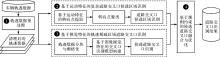
图1
融合视觉特征与运动特征的道路交叉口提取方法框架"
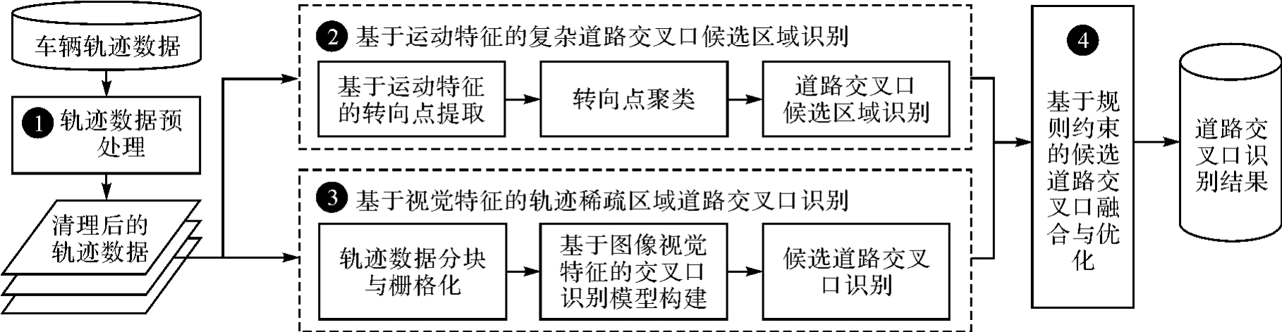
图2
轨迹数据清理与栅格化处理"
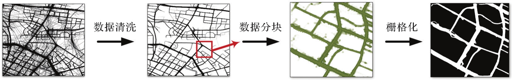
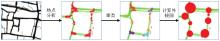
图3
道路交叉口候选区域识别"
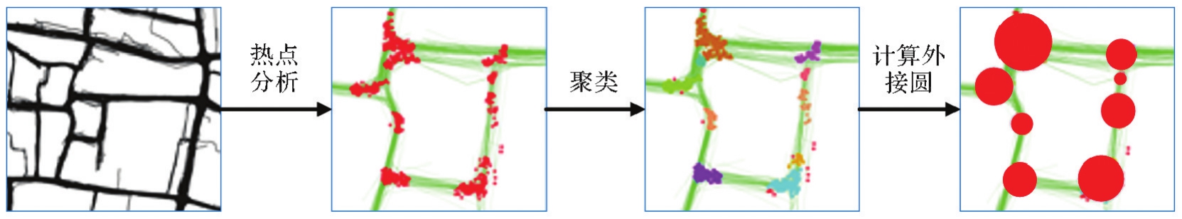

图4
基于视觉特征的道路交叉口识别模型"
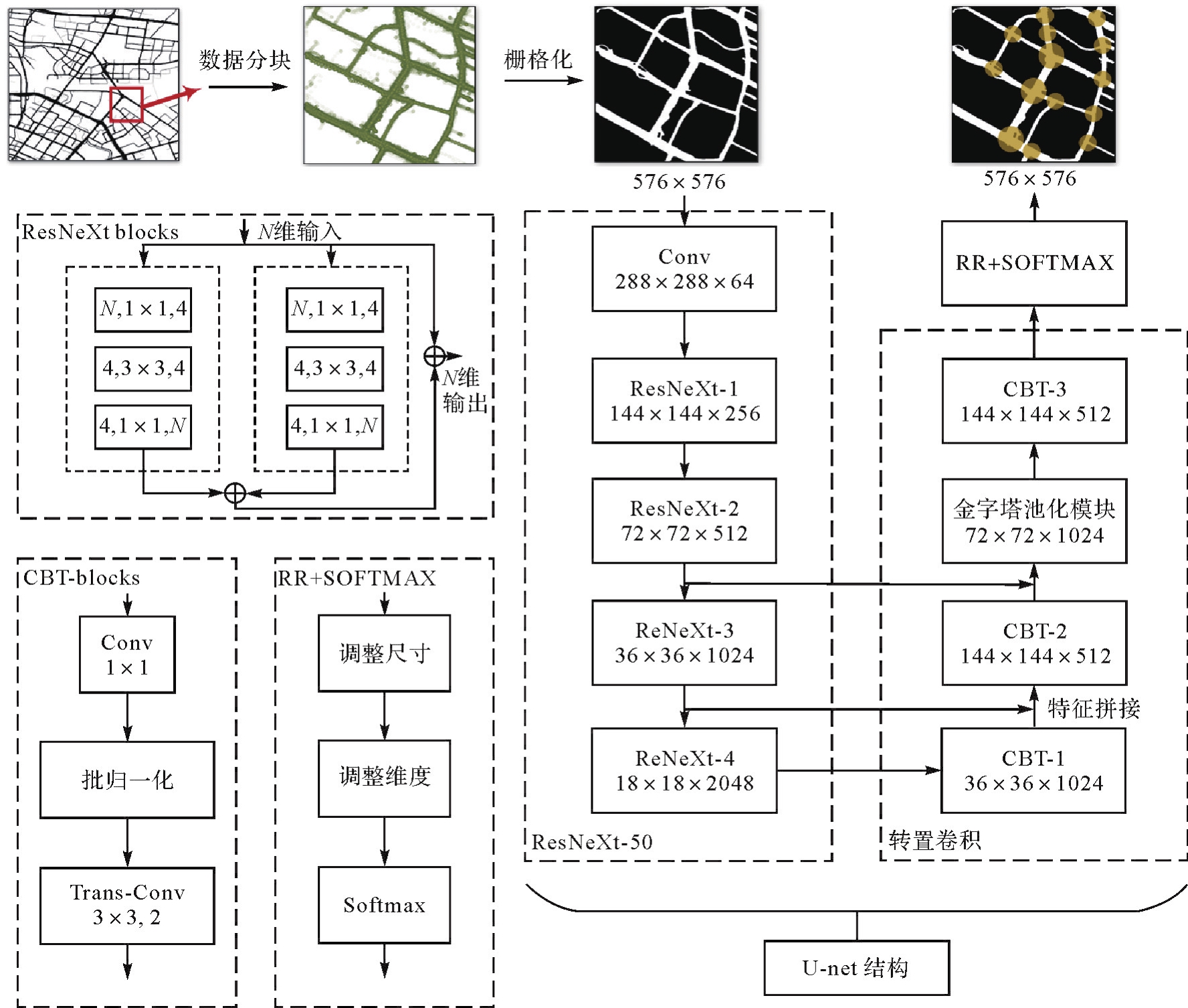
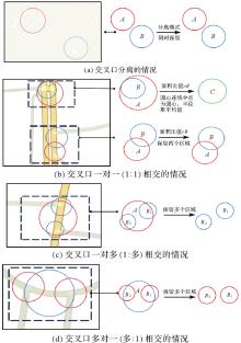
图5
不同道路交叉口的融合策略"
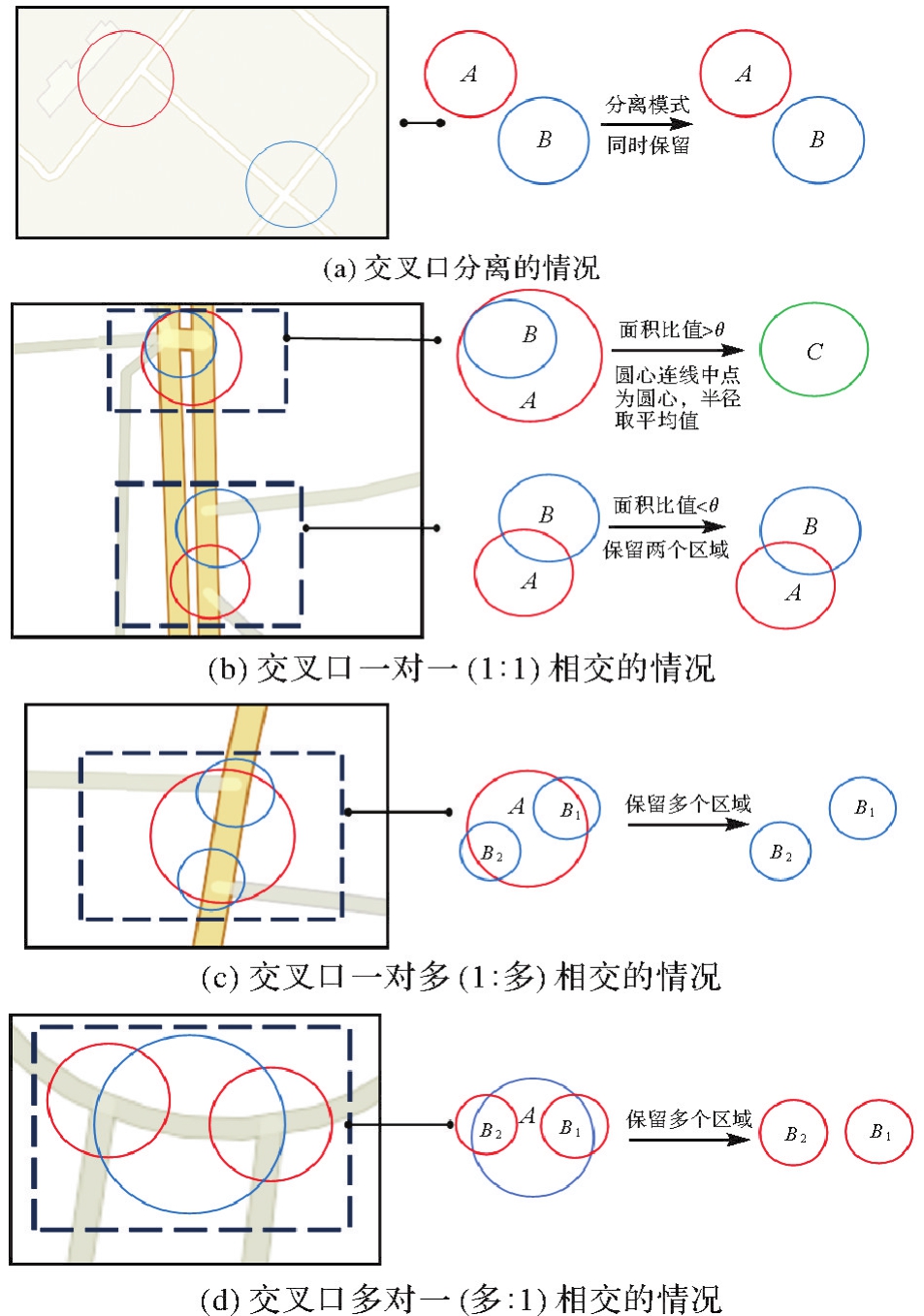
图6
研究区域与试验数据"
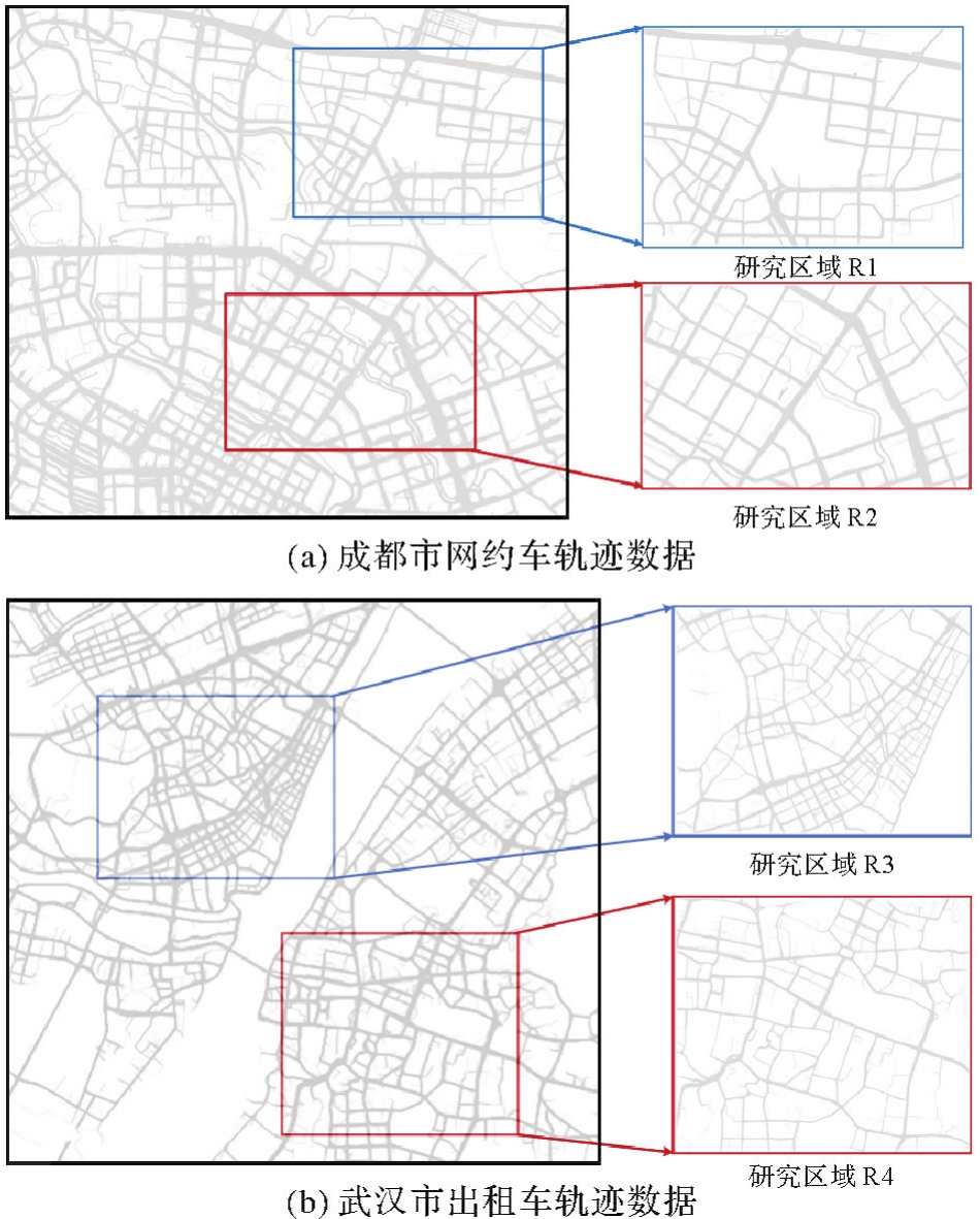
图7
基于视觉特征的道路交叉口识别结果"
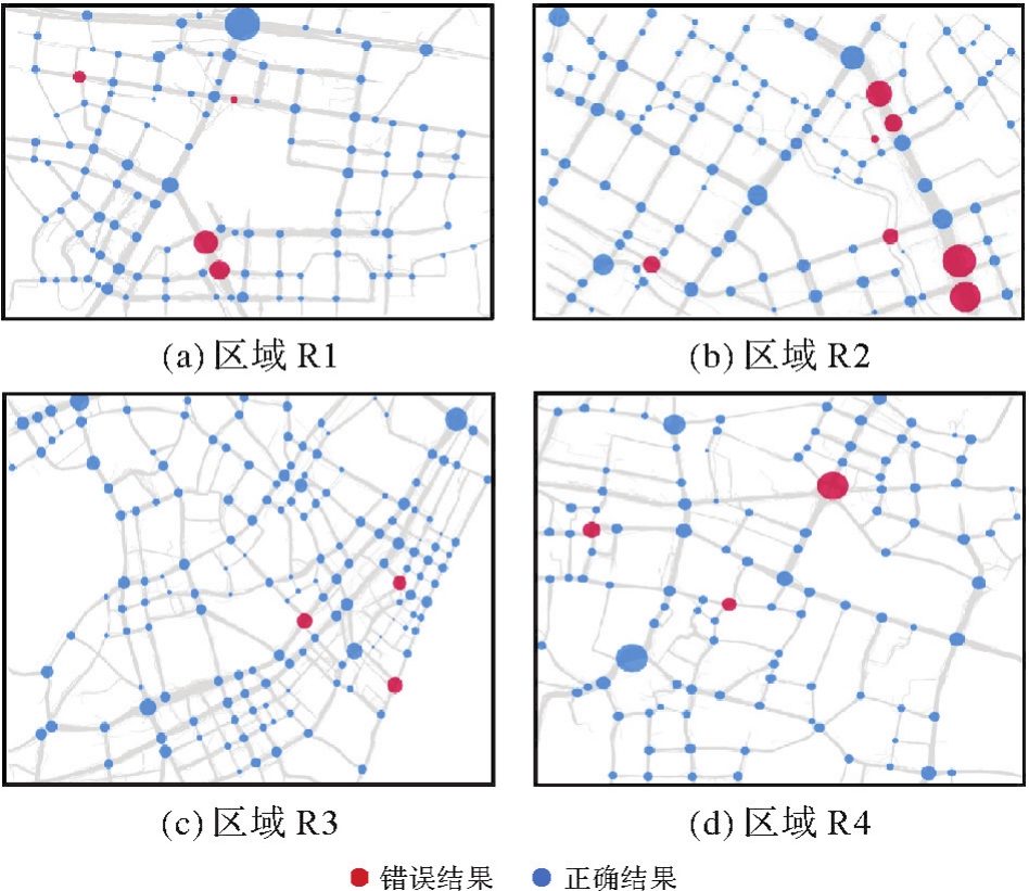
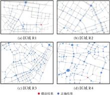
图8
基于运动特征的道路交叉口识别结果"
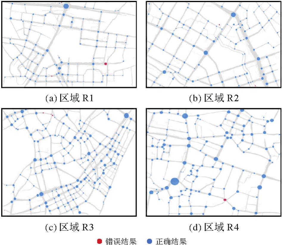
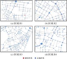
图9
融合视觉与运动特征的交叉口识别结果"

表1
交叉口识别结果精度评价"
| 研究区 | 指标 | 基于视觉特征的识别方法[ | 基于转向角权重的均值漂移聚类方法[ | 基于运动特征的识别方法[ | 密度峰值聚类与数学形态学融合的方法[ | 转向点对聚类方法[ | VM-UNet[ | 本文方法 |
|---|---|---|---|---|---|---|---|---|
| R1 | 精确度/(%) | 96.43 | 70.87 | 97.27 | 71.05 | 78.85 | 73.44 | 98.44 |
| 召回率/(%) | 82.44 | 55.73 | 81.68 | 61.83 | 62.60 | 71.76 | 96.18 | |
| F1值 | 0.888 9 | 0.623 9 | 0.888 0 | 0.661 2 | 0.697 9 | 0.725 9 | 0.973 0 | |
| R2 | 精确度/(%) | 94.12 | 71.54 | 97.58 | 70.21 | 77.17 | 80.83 | 96.67 |
| 召回率/(%) | 75.17 | 59.06 | 81.21 | 66.44 | 65.77 | 65.10 | 97.32 | |
| F1值 | 0.835 8 | 0.647 1 | 0.886 4 | 0.682 8 | 0.710 1 | 0.721 2 | 0.969 9 | |
| R3 | 精确度/(%) | 96.88 | 72.52 | 97.04 | 79.51 | 75.11 | 75.59 | 97.12 |
| 召回率/(%) | 64.05 | 78.51 | 81.40 | 67.36 | 68.60 | 79.34 | 97.52 | |
| F1值 | 0.771 1 | 0.754 0 | 0.885 4 | 0.729 3 | 0.717 1 | 0.774 2 | 0.973 2 | |
| R4 | 精确度/(%) | 96.36 | 73.53 | 97.40 | 76.16 | 80.67 | 71.05 | 98.20 |
| 召回率/(%) | 63.10 | 74.40 | 89.29 | 68.45 | 72.02 | 80.36 | 97.62 | |
| F1值 | 0.762 6 | 0.739 6 | 0.931 7 | 0.721 0 | 0.761 0 | 0.754 2 | 0.979 1 |
表2
交叉口识别方法运行时间"
| 方法 | R1识别用时 | R2识别用时 | R3识别用时 | R4识别用时 |
|---|---|---|---|---|
| 基于视觉特征的识别方法[ | 29.81 | 49.63 | 30.87 | 33.09 |
| 基于转向角权重的均值漂移聚类方法[ | 3 186.18 | 12 183.47 | 1 966.00 | 1 921.70 |
| 基于运动特征的识别方法[ | 324.34 | 1 300.60 | 105.06 | 131.26 |
| 密度峰值聚类与数学形态学融合的识别方法[ | 348.24 | 740.25 | 80.20 | 81.65 |
| 转向点对聚类方法[ | 1 359.30 | 2 512.02 | 700.07 | 737.13 |
| VM-U Net[ | 31.72 | 51.52 | 33.28 | 35.79 |
| 本文方法 | 355.77 | 1 351.90 | 136.24 | 164.57 |
表3
研究区域R4交叉口融合阈值分析"
| 阈值 | 10% | 20% | 30% | 40% | 50% | 60% | 70% | 80% | 90% | 95% |
|---|---|---|---|---|---|---|---|---|---|---|
| 精确度/(%) | 96.97 | 96.97 | 98.20 | 98.20 | 98.20 | 98.20 | 98.20 | 98.20 | 98.20 | 98.20 |
| 召回率/(%) | 95.24 | 95.24 | 97.62 | 97.62 | 97.62 | 97.62 | 97.62 | 97.62 | 97.62 | 97.62 |
| F1值 | 0.961 0 | 0.961 0 | 0.979 1 | 0.979 1 | 0.979 1 | 0.979 1 | 0.979 1 | 0.979 1 | 0.979 1 | 0.979 1 |
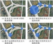
图10
复杂交叉口区域提取结果"

| [1] | CHEN Ziyi, DENG Liai, LUO Yuhua, et al. Road extraction in remote sensing data: a survey[J]. International Journal of Applied Earth Observation and Geoinformation, 2022, 112: 102833. |
| [2] | 王建伟, 高超, 董是, 等. 道路基础设施数字化研究进展与展望[J]. 中国公路学报, 2020, 33(11): 101-124. |
| WANG Jianwei, GAO Chao, DONG Shi, et al. Current status and future prospects of existing research on digitalization of highway infrastructure[J]. China Journal of Highway and Transport, 2020, 33(11): 101-124. | |
| [3] |
刘经南, 詹骄, 郭迟, 等. 智能高精地图数据逻辑结构与关键技术[J]. 测绘学报, 2019, 48(8): 939-953. DOI:.
doi: 10.11947/j.AGCS.2019.20190125 |
|
LIU Jingnan, ZHAN Jiao, GUO Chi, et al. Data logic structure and key technologies on intelligent high-precision map[J]. Acta Geodaetica et Cartographica Sinica, 2019, 48(8): 939-953. DOI:.
doi: 10.11947/j.AGCS.2019.20190125 |
|
| [4] |
吴华意, 黄蕊, 游兰, 等. 出租车轨迹数据挖掘进展[J]. 测绘学报, 2019, 48(11): 1341-1356. DOI:.
doi: 10.11947/j.AGCS.2019.20190210 |
|
WU Huayi, HUANG Rui, YOU Lan, et al. Recent progress in taxi trajectory data mining[J]. Acta Geodaetica et Cartographica Sinica, 2019, 48(11): 1341-1356. DOI:.
doi: 10.11947/j.AGCS.2019.20190210 |
|
| [5] |
唐炉亮, 牛乐, 杨雪, 等. 利用轨迹大数据进行城市道路交叉口识别及结构提取[J]. 测绘学报, 2017, 46(6): 770-779. DOI:.
doi: 10.11947/j.AGCS.2017.20160614 |
|
TANG Luliang, NIU Le, YANG Xue, et al. Urban intersection recognition and construction based on big trace data[J]. Acta Geodaetica et Cartographica Sinica, 2017, 46(6): 770-779. DOI:.
doi: 10.11947/j.AGCS.2017.20160614 |
|
| [6] | GONG Jianya, JI Shunping. Photogrammetry and deep learning[J]. Journal of Geodesy and Geoinformation Science, 2018, 1(1): 1-15. |
| [7] | HE Hao, WANG Shuyang, WANG Shicheng, et al. A road extraction method for remote sensing image based on encoder-decoder network[J]. Journal of Geodesy and Geoinformation Science, 2020, 3(2): 16-25. |
| [8] | 邵小美, 张春亢, 韦永昱, 等. 改进YOLOv3算法的遥感图像道路交叉口自动识别[J]. 航天返回与遥感, 2022, 43(5): 123-132. |
| SHAO Xiaomei, ZHANG Chunkang, WEI Yongyu, et al. Improved YOLOv3 algorithm for remote sensing image road automatic intersection identification[J]. Spacecraft Recovery & Remote Sensing, 2022, 43(5): 123-132. | |
| [9] | TANG Jianbo, DENG Min, HUANG Jincai, et al. An automatic method for detection and update of additive changes in road network with GPS trajectory data[J]. ISPRS International Journal of Geo-Information, 2019, 8(9): 411. |
| [10] |
唐炉亮, 刘章, 杨雪, 等. 符合认知规律的时空轨迹融合与路网生成方法[J]. 测绘学报, 2015(11): 1271-1276. DOI:.
doi: 10.11947/j.AGCS.2015.20140591 |
|
TANG Luliang, LIU Zhang, YANG Xue, et al. A method of spatio-temporal trajectory fusion and road network generation based on cognitive law[J]. Acta Geodaetica et Cartographica Sinica, 2015(11): 1271-1276. DOI:.
doi: 10.11947/j.AGCS.2015.20140591 |
|
| [11] | WANG Jing, RUI Xiaoping, SONG Xianfeng, et al. A novel approach for generating routable road maps from vehicle GPS traces[J]. International Journal of Geographical Information Science, 2015, 29(1): 69-91. |
| [12] | LI Yali, XIANG Longgang, ZHANG Caili, et al. A guided deep learning approach for joint road extraction and intersection detection from RS images and taxi trajectories[J]. IEEE Journal of Selected Topics in Applied Earth Observations and Remote Sensing, 2021, 14: 8008-8018. |
| [13] | CHEN Xin, XIANG Longgang, JIAO Fengwei, et al. Detecting turning relationships and time restrictions of OSM road intersections from crowdsourced trajectories[J]. ISPRS International Journal of Geo-Information, 2023, 12(9): 372. |
| [14] | 陈伟亮, 杜久升. 一种利用低频轨迹数据提取道路交叉口的方法[J]. 测绘通报, 2023(1): 127-133. |
| CHEN Weiliang, DU Jiusheng. A method of extracting road intersections using low frequency trajectory data[J]. Bulletin of Surveying and Mapping, 2023(1): 127-133. | |
| [15] | 孟秋宇, 宋子昂, 王金, 等. 利用浮动车GPS轨迹识别与提取城市道路交叉口[J]. 测绘通报, 2021(9): 59-63. |
| MENG Qiuyu, SONG Ziang, WANG Jin, et al. Detection and extraction of urban road intersections using GPS trajectories of floating vehicles[J]. Bulletin of Surveying and Mapping, 2021(9): 59-63. | |
| [16] | EZZAT M, SAKR M, ELGOHARY R, et al. Building road segments and detecting turns from GPS tracks[J]. Journal of Computational Science, 2018, 29: 81-93. |
| [17] | DENG Min, HUANG Jincai, ZHANG Yunfei, et al. Generating urban road intersection models from low-frequency GPS trajectory data[J]. International Journal of Geographical Information Science, 2018, 32(12): 2337-2361. |
| [18] | LIU Yizhi, QING Rutian, ZHAO Yijiang, et al. Road intersection recognition via combining classification model and clustering algorithm based on GPS data[J]. ISPRS International Journal of Geo-Information, 2022, 11(9): 487. |
| [19] | DAVIES J J, BERESFORD A R, HOPPER A. Scalable, distributed, real-time map generation[J]. IEEE Pervasive Computing, 2006, 5(4): 47-54. |
| [20] | BIAGIONI J, ERIKSSON J. Map inference in the face of noise and disparity[C]//Proceedings of the 20th International Conference on Advances in Geographic Information Systems. New York: ACM Press, 2012: 79-88. |
| [21] | KUNTZSCH C, SESTER M, BRENNER C. Generative models for road network reconstruction[J]. International Journal of Geographical Information Science, 2016, 30(5): 1012-1039. |
| [22] | MARIESCU-ISTODOR R, FRÄNTI P. CellNet: inferring road networks from GPS trajectories[J]. ACM Transactions on Spatial Algorithms and Systems, 2018, 4(3): 1-22. |
| [23] | ZHANG Ju, HU Qingwu, LI Jiayuan, et al. Learning from GPS trajectories of floating car for CNN-based urban road extraction with high-resolution satellite imagery[J]. IEEE Transactions on Geoscience and Remote Sensing, 2021, 59(3): 1836-1847. |
| [24] | YIN Yifang, SUNDERRAJAN A, HUANG Xiaocheng, et al. Multi-scale graph convolutional network for intersection detection from GPS trajectories[C]//Proceedings of the 3rd ACM SIGSPATIAL International Workshop on AI for Geographic Knowledge Discovery. Chicago: ACM Press, 2019: 36-39. |
| [25] |
邓敏, 罗斌, 唐建波, 等. 顾及轨迹密度分布异质性的道路交叉口提取方法[J]. 测绘学报, 2023, 52(6): 1000-1009. DOI:.
doi: 10.11947/j.AGCS.2023.20210173 |
|
DENG Min, LUO Bin, TANG Jianbo, et al. Extracting road intersections from vehicle trajectory data in the face of trace density disparity[J]. Acta Geodaetica et Cartographica Sinica, 2023, 52(6): 1000-1009. DOI:.
doi: 10.11947/j.AGCS.2023.20210173 |
|
| [26] | ERRAMALINE A, BADARD T, CÔTÉ M P, et al. Identification of road network intersection types from vehicle telemetry data using a convolutional neural network[J]. ISPRS International Journal of Geo-Information, 2022, 11(9): 475. |
| [27] | 李思宇, 向隆刚, 张彩丽, 等. 基于低频出租车轨迹的城市路网交叉口提取研究[J]. 地球信息科学学报, 2019, 21(12): 1845-1854. |
| LI Siyu, XIANG Longgang, ZHANG Caili, et al. Extraction of urban road network intersections based on low-frequency taxi trajectory data[J]. Journal of Geo-information Science, 2019, 21(12): 1845-1854. | |
| [28] |
李雅丽, 向隆刚, 张彩丽, 等. 车辆轨迹与遥感影像多层次融合的道路交叉口识别[J]. 测绘学报, 2021, 50(11): 1546-1557. DOI:.
doi: 10.11947/j.AGCS.2021.20210255 |
|
LI Yali, XIANG Longgang, ZHANG Caili, et al. Road intersection recognition based on a multi-level fusion of vehicle trajectory and remote sensing image[J]. Acta Geodaetica et Cartographica Sinica, 2021, 50(11): 1546-1557. DOI:.
doi: 10.11947/j.AGCS.2021.20210255 |
|
| [29] | GETIS A, ORD J K. The analysis of spatial association by use of distance statistics[J]. Geographical Analysis, 1992, 24(3): 189-206. |
| [30] | DENG Min, LIU Qiliang, CHENG Tao, et al. An adaptive spatial clustering algorithm based on delaunay triangulation[J]. Computers, Environment and Urban Systems, 2011, 35(4): 320-332. |
| [31] | XIE Saining, GIRSHICK R, DOLLAR P, et al. Aggregated residual transformations for deep neural networks[C]//Proceedings of 2017 IEEE Conference on Computer Vision and Pattern Recognition. Honolulu: IEEE, 2017: 1492-1500. |
| [32] | RONNEBERGER O, FISCHER P, BROX T. U-Net: convolutional networks for biomedical image segmentation[C]//Proceedings of 2015 Medical Image Computing and Computer-Assisted Intervention. Cham: Springer, 2015: 234-241. |
| [33] | FRAENKEL A, BAR-HILLEL Y, LEVY A. Foundations of set theory[M]. [S.l.]: Elsevier, 1973: 15-153. |
| [34] | FREMLIN D. Measure theory[M]. Torres England: Fremlin, 2000: 9-34. |
| [35] | LYU Haiyang, PFOSER D, SHENG Yehua. Movement-aware map construction[J]. International Journal of Geographical Information Science, 2021, 35(6): 1065-1093. |
| [36] | RUAN Jiacheng, XIANG Suncheng. VM-UNet: vision mamba UNet for medical image segmentation[EB/OL]. [2024-02-04]. https://arxiv.org/pdf/2402.02491. |
| [1] | 黄文君, 孙群, 徐青, 范龙, 余岸竹, 张付兵. 融合频域特征与地形先验的全球沿海DEM超分辨率重建方法[J]. 测绘学报, 2025, 54(8): 1518-1531. |
| [2] | 万杰, 谢忠, 徐永洋, 陶留锋. 面向城市道路场景的车载LiDAR点云语义分割U形图卷积网络方法[J]. 测绘学报, 2025, 54(7): 1280-1293. |
| [3] | 赵一鸣, 胡克林, 涂可龙, 卿雅娴, 杨超, 祁昆仑, 吴华意. 基于SAR与光学遥感影像融合的多标签场景分类方法[J]. 测绘学报, 2025, 54(5): 911-923. |
| [4] | 焦凤伟, 向隆刚, 邓媛媛, 陈欣, 吴华意. 轨迹局部和长序特征结合的立交桥路网构建方法[J]. 测绘学报, 2025, 54(5): 950-962. |
| [5] | 曹云刚, 杨鹏, 龚江波, 朱高, 沈星宇. 空间关系增强与异构特征融合相结合的道路信息提取方法[J]. 测绘学报, 2025, 54(12): 2219-2232. |
| [6] | 龚良雄, 李星华, 程远明, 赵兴友, 谢仁平, 王红根. 时空差异增强与自适应特征融合的轻量级遥感影像变化检测网络[J]. 测绘学报, 2025, 54(1): 136-153. |
| [7] | 张付兵, 孙群, 马京振, 孙士杰, 温伯威. 融合全局和局部特征的建筑物形状智能分类方法[J]. 测绘学报, 2024, 53(9): 1842-1852. |
| [8] | 鄢薪, 慎利, 潘俊杰, 戴延帅, 王继成, 郑晓莉, 李志林. 多尺度特征融合与空间优化的弱监督高分遥感建筑变化检测[J]. 测绘学报, 2024, 53(8): 1586-1597. |
| [9] | 徐涛, 杨元维, 高贤君, 王志威, 潘越, 李少华, 许磊, 王艳军, 刘波, 余静, 吴凤敏, 孙浩宇. 融合图卷积与多尺度特征的接触网点云语义分割[J]. 测绘学报, 2024, 53(8): 1624-1633. |
| [10] | 林云浩, 王艳军, 李少春, 蔡恒藩. 一种耦合DeepLab与Transformer的农作物种植类型遥感精细分类方法[J]. 测绘学报, 2024, 53(2): 353-366. |
| [11] | 张彩丽, 向隆刚, 李雅丽, 高松峰, 潘传姣. 路段级导航属性信息挖掘[J]. 测绘学报, 2024, 53(2): 367-378. |
| [12] | 庞世燕, 郝京京, 左志奇, 兰晶晶, 胡翔云. 融合密集连接和自注意力机制的高分辨率遥感影像变化检测方法[J]. 测绘学报, 2024, 53(12): 2244-2253. |
| [13] | 邓敏, 罗斌, 唐建波, 姚志鹏, 刘国平, 温翔, 胡润波, 柴华, 胡文柯. 顾及轨迹密度分布异质性的道路交叉口提取方法[J]. 测绘学报, 2023, 52(6): 1000-1009. |
| [14] | 宋佳璇, 范大昭, 董杨, 纪松, 李东子. 神经网络学习与灰度信息结合的跨视角影像线特征匹配算法[J]. 测绘学报, 2023, 52(6): 990-999. |
| [15] | 刘帅, 李笑迎, 于梦, 邢光龙. 高分辨率遥感图像双解耦语义分割网络模型[J]. 测绘学报, 2023, 52(4): 638-647. |
| 阅读次数 | ||||||
|
全文 |
|
|||||
|
摘要 |
|
|||||