


测绘学报 ›› 2025, Vol. 54 ›› Issue (4): 636-649.doi: 10.11947/j.AGCS.2025.20240115
陈军1,2,3( ), 田海波1,4, 高崟1,2(), 张元杰1,2, 刘万增1,2, 武昊1,2, 张宏伟1,3, 黄蔚1, 刘建军1,2
收稿日期:2024-03-22
出版日期:2025-05-30
发布日期:2025-05-30
通讯作者:
高崟
E-mail:chenjun@ngcc.cn;gaoyin@ngcc.cn
作者简介:陈军(1956—),男,教授,中国工程院院士,研究方向为时空信息建模、更新与服务。 E-mail:chenjun@ngcc.cn
基金资助:
Jun CHEN1,2,3(), Haibo TIAN1,4, Yin GAO1,2(), Yuanjie ZHANG1,2, Wanzeng LIU1,2, Hao WU1,2, Hongwei ZHANG1,3, Wei HUANG1, Jianjun LIU1,2
Received:2024-03-22
Online:2025-05-30
Published:2025-05-30
Contact:
Yin GAO
E-mail:chenjun@ngcc.cn;gaoyin@ngcc.cn
About author:CHEN Jun (1956—), male, professor, academician of Chinese Academy of Engineering, majors in data modeling, updating and service of geospatial information. E-mail: chenjun@ngcc.cn
Supported by:摘要:
实景三维中国建设是落实数字中国建设战略、推进国土空间治理现代化、加快测绘地理信息转型升级的一项重要举措,既是今后数十年国家和地方基础测绘的重大任务,也是一项涉及因素复杂、技术难度极大的科技工程。本文介绍了实景三维中国建设的基本思路,从4D产品到实景三维、从数据供给到时空赋能、从数字化到数智化;提出了实景三维中国总体技术架构,包括由地理实体、地理场景、地理实景等组成的产品体系,以提供时空连接、时空计算、时空智能服务为目标的服务赋能体系,以数智化生产、实体化管理、知识化服务为重点的数智技术体系;继而讨论了实景三维中国的主体技术,包括实体化建模、立体化重构、真实化描述和知识化服务等;最后从推动实景三维中国与“五位一体”总体布局深度融合的角度,探讨了实景三维赋能数字经济、数字治理、数字生活、数字文化、数字生态文明等5个应用场景。为切实做好实景三维中国建设与应用,今后还应加强战略谋划,推动科技创新,促进跨界融合。
中图分类号:
陈军, 田海波, 高崟, 张元杰, 刘万增, 武昊, 张宏伟, 黄蔚, 刘建军. 实景三维中国的总体架构与主体技术[J]. 测绘学报, 2025, 54(4): 636-649.
Jun CHEN, Haibo TIAN, Yin GAO, Yuanjie ZHANG, Wanzeng LIU, Hao WU, Hongwei ZHANG, Wei HUANG, Jianjun LIU. China's National 3D Mapping Program (3DRGLM): overall architecture and key technological issues[J]. Acta Geodaetica et Cartographica Sinica, 2025, 54(4): 636-649.

图1
实景三维概念内涵"
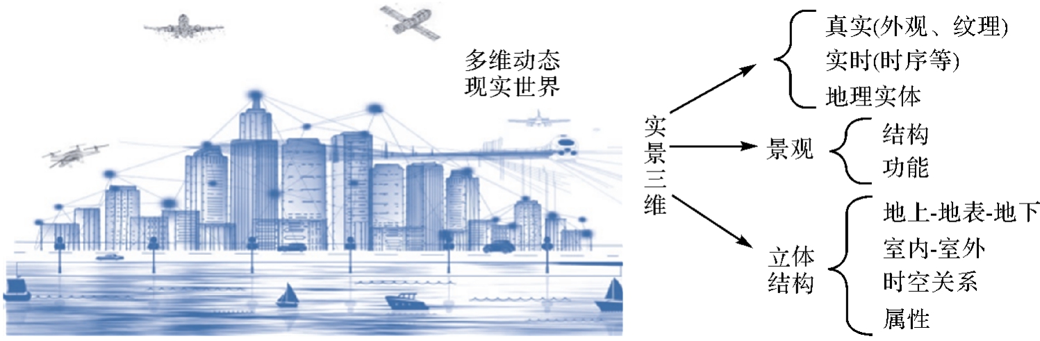

图2
实景三维中国的总体架构"
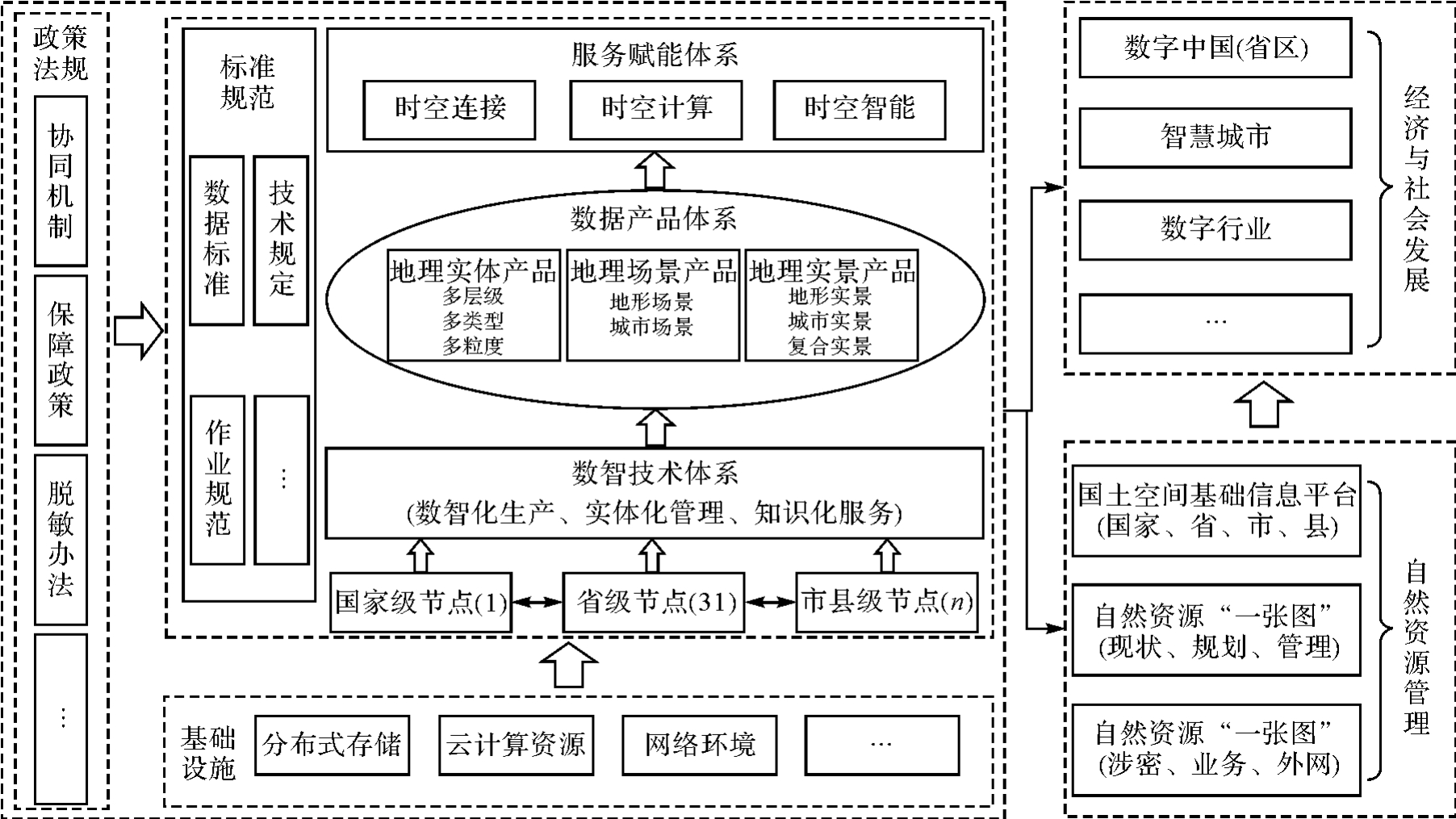
图3
实景三维数据产品体系"

图4
实景三维服务赋能体系"

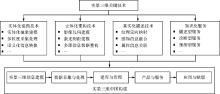
图5
实景三维中国的主体技术"

| [1] | 陈军, 王艳慧, 武昊, 等. 时空信息赋能高质量发展的基本问题与发展方向[J]. 时空信息学报, 2023, 30(1): 1-11. |
| CHEN Jun, WANG Yanhui, WU Hao, et al. Basic issues and development directions of high-quality development empowered by spatio-temporal information[J]. Journal of Spatio-Temporal Information, 2023, 30(1): 1-11. | |
| [2] |
宁津生, 王正涛. 从测绘学向地理空间信息学演变历程[J]. 测绘学报, 2017, 46(10): 1213-1218. DOI:.
doi: 10.11947/j.AGCS.2017.20170375 |
|
NING Jinsheng, WANG Zhengtao. Progresses from surveying and mapping to geomatics[J]. Acta Geodaetica et Cartographica Sinica, 2017, 46(10): 1213-1218. DOI:.
doi: 10.11947/j.AGCS.2017.20170375 |
|
| [3] | 中共中央 国务院印发《数字中国建设整体布局规划》[EB/OL]. [2024-02-03]. https://www.gov.cn/xinwen/2023-02/27/content_5743484.htm. |
| The Central Committee of the Communist Party of China and the State Council have issued the “overall layout plan for the construction of digital China”[EB/OL]. [2024-02-03]. https://www.gov.cn/xinwen/2023-02/27/content_5743484.htm. | |
| [4] | 陈军, 武昊, 张继贤, 等. 自然资源调查监测技术体系构建的方向与任务[J]. 地理学报, 2022, 77(5): 1041-1055. |
| CHEN Jun, WU Hao, ZHANG Jixian, et al. Building natural resources surveying and monitoring technological system: direction and research agenda[J]. Acta Geographica Sinica, 2022, 77(5): 1041-1055. | |
| [5] |
刘万增, 陈军, 翟曦, 等. 时空知识中心的研究进展与应用[J]. 测绘学报, 2021, 50(9): 1183-1193. DOI:.
doi: 10.11947/j.AGCS.2021.20210160 |
|
LIU Wanzeng, CHEN Jun, ZHAI Xi, et al. Research progress and application of spatiotemporal knowledge center[J]. Acta Geodaetica et Cartographica Sinica, 2021, 50(9): 1183-1193. DOI:.
doi: 10.11947/j.AGCS.2021.20210160 |
|
| [6] | 曹小曙. 基于人地耦合系统的国土空间重塑[J]. 自然资源学报, 2019, 34(10): 2051-2059. |
| CAO Xiaoshu. Geogovernance of national land use based on coupled human and natural systems[J]. Journal of Natural Resources, 2019, 34(10): 2051-2059. | |
| [7] | 甄峰, 张姗琪, 秦萧, 等. 从信息化赋能到综合赋能:智慧国土空间规划思路探索[J]. 自然资源学报, 2019, 34(10): 2060-2072. |
| ZHEN Feng, ZHANG Shanqi, QIN Xiao, et al. From informational empowerment to comprehensive empowerment: exploring the ideas of smart territorial spatial planning[J]. Journal of Natural Resources, 2019, 34(10): 2060-2072. | |
| [8] | O'SULLIVAN L, BOVET S, STREILEIN A. TLM—the swiss 3D topographic landscape model. International archives of the photogrammetry[J]. Remote Sensing and Spatial Information Sciences Proceedings, 2008; 37(1): 1715-9. |
| [9] | STOTER J E, STREILEIN A, PLA M, et al. Approaches of national 3D mapping: research results and standardisation in practice[J]. ISPRS Annals of Photogrammetry, Remote Sensing and Spatial Information Sciences, 2013, II2: 269-278. |
| [10] | WONG K, ELLUL C. User requirements gathering for a national 3D mapping product in the United Kingdom[J]. International Archives of the Photogrammetry, Remote Sensing and Spatial Information Sciences-ISPRS Archives, 2018, 4(4/W6): 89-96. |
| [11] | 华一新, 赵鑫科, 张江水. 地理信息系统研究新范式[J]. 地球信息科学学报, 2023, 25(1): 15-24. |
| HUA Yixin, ZHAO Xinke, ZHANG Jiangshui. New paradigm of geographic information systems research[J]. Journal of Geo-Information Science, 2023, 25(1): 15-24. | |
| [12] | 陈军, 刘建军, 田海波. 实景三维中国建设的基本定位与技术路径[J]. 武汉大学学报(信息科学版), 2022, 47(10): 1568-1575. |
| CHEN Jun, LIU Jianjun, TIAN Haibo. Basic directions and technological path for building 3D realistic geospatial scene in China[J]. Geomatics and Information Science of Wuhan University, 2022, 47(10): 1568-1575. | |
| [13] | 中华人民共和国自然资源部. 自然资源部办公厅关于全面推进实景三维中国建设的通知[EB/OL]. [2024-02-03]. http://gi.mnr.gov.cn/202202/t20220225_2729401.html. |
| Ministry of Natural Resources of the People's Republic of China. Notice from the General Office of the Ministry of Natural Resources on fully promoting the construction of realistic 3D China[EB/OL]. [2024-02-03]. http://gi.mnr.gov.cn/202202/t20220225_2729401.html. | |
| [14] | JIANG Jie, CHEN Jun. International sate-of-the-art of photogrammetry and remote sensing[J]. Geo-Matics World, 2003, 10(1): 16-9. |
| [15] | 杨凯. 国际摄影测量与遥感学会(ISPRS)第二十届大会情况[J]. 测绘工程, 2005, 14(1): 1-4. |
| YANG Kai. The 20th congress of the International Society for Photogrammetry and Remote Sensing (ISPRS)[J]. Engineering of Surveying and Mapping, 2005, 14(1): 1-4. | |
| [16] | HOLLAND D A, ALLAN L E. The digital national framework and digital photogrammetry at ordnance survey[J]. The Photogrammetric Record, 2001, 17(98): 291-301. |
| [17] | SOON K, KHOO V. CityGML modelling for Singapore 3D national mapping[J]. The International Archives of the Photogrammetry, Remote Sensing and Spatial Information Sciences, 2017, 42(1): 37-42. |
| [18] | 姚巍, 王谱佐. 实景三维技术发展态势——XXIV ISPRS Congress报告[J]. 时空信息学报, 2023, 30(2): 167-76. |
| YAO Wei, WANG Puzuo. The development trend of realistic 3D technology - report of XXIV ISPRS Congress[J]. Journal of Spatiotemporal Information, 2023, 30(2): 167-76. | |
| [19] |
朱庆, 张利国, 丁雨淋, 等. 从实景三维建模到数字孪生建模[J]. 测绘学报, 2022, 51(6): 1040-1049. DOI:.
doi: 10.11947/j.AGCS.2022.20210640 |
|
ZHU Qing, ZHANG Liguo, DING Yulin, et al. From real 3D modeling to digital twin modeling[J]. Acta Geodaetica et Cartographica Sinica, 2022, 51(6): 1040-1049. DOI:.
doi: 10.11947/j.AGCS.2022.20210640 |
|
| [20] |
单杰, 李志鑫, 张文元. 大规模三维城市建模进展[J]. 测绘学报, 2019, 48(12): 1523-1541. DOI:.
doi: 10.11947/j.AGCS.2019.20190471 |
|
SHAN Jie, LI Zhixin, ZHANG Wenyuan. Recent progress in large-scale 3D city modeling[J]. Acta Geodaetica et Cartographica Sinica, 2019, 48(12): 1523-1541. DOI:.
doi: 10.11947/j.AGCS.2019.20190471 |
|
| [21] | 陈军. 专家透析 数字中国大厦的空间框架[J]. 中国测绘, 2003(1): 18-19. |
| CHEN Jun. Expert analysis of the spatial framework of Digital China Tower[J]. China Surveying and Mapping, 2003(1): 18-19. | |
| [22] | 康志忠, 杨俊涛. 室内实景三维重建技术综述[J]. 时空信息学报, 2024, 31(1): 1-10. |
| KANG Zhizhong, YANG Juntao. Review of indoor real scene 3D reconstruction technology[J]. Journal of Spatio-Temporal Information, 2024, 31(1): 1-10. | |
| [23] | 林珲, 游兰, 胡传博, 等. 时空大数据时代的地理知识工程展望[J]. 武汉大学学报(信息科学版), 2018, 43(12): 2205-2211. |
| LIN Hui, YOU Lan, HU Chuanbo, et al. Prospect of geo-knowledge engineering in the era of spatio-temporal big data[J]. Geomatics and Information Science of Wuhan University, 2018, 43(12): 2205-2211. | |
| [24] | 刘瑜, 康朝贵, 王法辉. 大数据驱动的人类移动模式和模型研究[J]. 武汉大学学报(信息科学版), 2014, 39(6): 660-666. |
| LIU Yu, KANG Chaogui, WANG Fahui. Towards big data-driven human mobility patterns and models[J]. Geomatics and Information Science of Wuhan University, 2014, 39(6): 660-666. | |
| [25] |
陈军, 武昊, 刘万增, 等. 自然资源时空信息的技术内涵与研究方向[J]. 测绘学报, 2022, 51(7): 1130-1140. DOI:.
doi: 10.11947/j.AGCS.2022.20210643 |
|
CHEN Jun, WU Hao, LIU Wanzeng, et al. Technical connotation and research agenda of natural resources spatio-temporal information[J]. Acta Geodaetica et Cartographica Sinica, 2022, 51(7): 1130-1140. DOI:.
doi: 10.11947/j.AGCS.2022.20210643 |
|
| [26] | TOSTA N, DOMARATZ M. The US national spatial data infrastructure[J]. Geographic Information Research, 2020, 1: 19-27. |
| [27] | 陈军, 丁明柱, 蒋捷, 等. 从离线数据提供到在线地理信息服务[J]. 地理信息世界, 2009, 16(2): 6-9. |
| CHEN Jun, DING Mingzhu, JIANG Jie, et al. From off-line data provision to online geo-information service[J]. Geomatics World, 2009, 16(2): 6-9. | |
| [28] | 陈军, 蒋捷, 周旭, 等. 地理信息公共服务平台的总体技术设计研究[J]. 地理信息世界, 2009, 16(3): 7-11, 36. |
| CHEN Jun, JIANG Jie, ZHOU Xu, et al. Design of national geo-spatial information service platform: overall structure and key components[J]. Geomatics World, 2009, 16(3): 7-11, 36. | |
| [29] | 李然, 王海清, 刘万增, 等. 大规模地理信息资源目录集成服务的技术框架及系统应用[J]. 地理信息世界, 2020, 27(4): 46-51. |
| LI Ran, WANG Haiqing, LIU Wanzeng, et al. Technological framework and applications of the catalog service for large-scale geographic information resources[J]. Geomatics World, 2020, 27(4): 46-51. | |
| [30] | 高崟, 刘建军. 用三维时空数据建自然资源“一张图”[N]. 中国自然资源报, 2020-9-8: 7. |
| GAO Yin, LIU Jianjun. Building a “map” of natural resources with 3D spatiotemporal data[N]. China Natural Resources Journal, 2020-9-8: 7. | |
| [31] | 郭仁忠, 林浩嘉, 贺彪, 等. 面向智慧城市的GIS框架[J]. 武汉大学学报(信息科学版), 2020, 45(12): 1829-1835. |
| GUO Renzhong, LIN Haojia, HE Biao, et al. GIS framework for smart cities[J]. Geomatics and Information Science of Wuhan University, 2020, 45(12): 1829-1835. | |
| [32] |
龚健雅, 张翔, 向隆刚, 等. 智慧城市综合感知与智能决策的进展及应用[J]. 测绘学报, 2019, 48(12): 1482-1497. DOI:.
doi: 10.11947/j.AGCS.2019.20190464 |
|
GONG Jianya, ZHANG Xiang, XIANG Longgang, et al. Progress and applications for integrated sensing and intelligent decision in smart city[J]. Acta Geodaetica et Cartographica Sinica, 2019, 48(12): 1482-1497. DOI:.
doi: 10.11947/j.AGCS.2019.20190464 |
|
| [33] |
王家耀. 时空大数据时代的地图学[J]. 测绘学报, 2017, 46(10): 1226-1237. DOI:.
doi: 10.11947/j.AGCS.2017.20170308 |
|
WANG Jiayao. Cartography in the age of spatio-temporal big data[J]. Acta Geodaetica et Cartographica Sinica, 2017, 46(10): 1226-1237. DOI:.
doi: 10.11947/j.AGCS.2017.20170308 |
|
| [34] | 陈军. 论中国地理信息系统的发展方向[J]. 地理信息世界, 2003, 10(1): 6-11. |
| CHEN Jun. Directions of GIS development in China: an overview[J]. Research Soft-Science of Surveying and Mapping, 2003, 10(1): 6-11. | |
| [35] | 陈军, 武昊, 李松年, 等. 面向大数据时代的地表覆盖动态服务计算[J]. 测绘科学技术学报, 2013, 30(4): 369-374. |
| CHEN Jun, WU Hao, LI Songnian, et al. Services oriented dynamic computing for land cover big data[J]. Journal of Geomatics Science and Technology, 2013, 30(4): 369-374. | |
| [36] | 刘万增, 陈军. 时空信息的基本内涵与赋能机理[J]. 地理学报, 2024, 79(5): 1099-1114. |
| LIU Wanzeng, CHEN Jun. The basic connotation and empowerment mechanism of spatio-temporal information[J]. Acta Geographica Sinica, 2024, 79(5): 1099-1114. | |
| [37] | 乔朝飞, 陈常松, 徐坤, 等. 提高我国地理信息公共服务水平的若干思考[J]. 地理信息世界, 2022, 29(4): 1-4. |
| QIAO Chaofei, CHEN Changsong, XU Kun, et al. Thoughts on improving the geoinformation public service level in China[J]. Geomatics World, 2022, 29(4): 1-4. | |
| [38] |
陈军, 刘万增, 武昊, 等. 智能化测绘的基本问题与发展方向[J]. 测绘学报, 2021, 50(8): 995-1005. DOI:.
doi: 10.11947/j.AGCS.2021.20210235 |
|
CHEN Jun, LIU Wanzeng, WU Hao, et al. Smart surveying and mapping: fundamental issues and research agenda[J]. Acta Geodaetica et Cartographica Sinica, 2021, 50(8): 995-1005. DOI:.
doi: 10.11947/j.AGCS.2021.20210235 |
|
| [39] | 沈阳, 余梦珑. 元宇宙与大数据:时空智能中的数据洞察与价值连接[J]. 大数据, 2023, 9(1): 103-110. |
| SHEN Yang, YU Menglong. Metaverse and big data: data insight and value connection in spatio-temporal intelligence[J]. Big Data Research, 2023, 9(1): 103-110. | |
| [40] | 刘万增, 陈军, 任加新, 等. 基于混合智能的地图自动审核技术框架[J]. 武汉大学学报(信息科学版), 2022, 47(12): 2038-2046. |
| LIU Wanzeng, CHEN Jun, REN Jiaxin, et al. Hybrid intelligence-based framework for automatic map inspecting technology[J]. Geomatics and Information Science of Wuhan University, 2022, 47(12): 2038-2046. | |
| [41] | 李德仁, 龚健雅, 邵振峰. 从数字地球到智慧地球[J]. 武汉大学学报(信息科学版), 2010, 35(2): 127-132, 253-254. |
| LI Deren, GONG Jianya, SHAO Zhenfeng. From digital earth to smart earth[J]. Geomatics and Information Science of Wuhan University, 2010, 35(2): 127-132, 253-254. | |
| [42] | 郭仁忠, 罗婷文. 土地资源智能管控[J]. 科学通报, 2019, 64(21): 2166-2171. |
| GUO Renzhong, LUO Tingwen. Intelligent management and control for land resources[J]. Chinese Science Bulletin, 2019, 64(21): 2166-2171. | |
| [43] |
刘耀林, 刘启亮, 邓敏, 等. 地理大数据挖掘研究进展与挑战[J]. 测绘学报, 2022, 51(7): 1544-1560. DOI:.
doi: 10.11947/j.AGCS.2022.20220068 |
|
LIU Yaolin, LIU Qiliang, DENG Min, et al. Recent advance and challenge in geospatial big data mining[J]. Acta Geodaetica et Cartographica Sinica, 2022, 51(7): 1544-1560. DOI:.
doi: 10.11947/j.AGCS.2022.20220068 |
|
| [44] | CHEN Jun, LI Zhilin, LI Songnian, et al. From digitalized to intelligentized surveying and mapping: fundamental issues and research agenda[J]. Journal of Geodesy and Geoinformation Science, 2022, 5(2): 148-160. |
| [45] | 刘万增, 陈军, 赵勇, 等. 地理信息保密安全评估的基本问题与对策[J]. 时空信息学报, 2023, 30(4): 474-481. |
| LIU Wanzeng, CHEN Jun, ZHAO Yong, et al. Fundamental issues and countermeasures of geographic information security assessment[J]. Journal of Spatio-Temporal Information, 2023, 30(4): 474-481. | |
| [46] | 蒋捷, 黄蔚, 卢卫华, 等. 地理信息公共服务平台地理实体数据建模研究[J]. 地理信息世界, 2009, 16(4): 11-18. |
| JIANG Jie, HUANG Wei, LU Weihua, et al. Research on entity-based data modeling for national geo-spatial information service platform[J]. Geomatics World, 2009, 16(4): 11-18. | |
| [47] | 陈军, 王东华, 商瑶玲, 等. 国家1∶50 000数据库更新工程总体设计研究与技术创新[J]. 测绘学报, 2010, 39(1): 7-10. |
| CHEN Jun, WANG Donghua, SHANG Yaoling, et al. Master design and technical development for national 1∶50 000 topographic database updating engineering in China[J]. Acta Geodaetica et Cartographica Sinica, 2010, 39(1): 7-10. | |
| [48] | 国家市场监督管理总局, 国家标准化管理委员会. 基础地理信息要素分类与代码:GB/T 13923—2022[S]. 北京: 中国标准出版社, 2022. |
| State Administration for Market Regulation, National Standardization Administration. Classification and codes for fundamental geographic information feature: GB/T 13923—2022[S]. Beijing: Standards Press of China, 2022. | |
| [49] | 北京市市场监督管理局. 基础地理实体分类与代码:DB11/T 2254—2024[S]. 北京: 北京市市场监督管理局, 2024. |
| Basic geographic entity classification and code: DB11/T 2254—2024[S]. Beijing: Beijing Municipal Administration for Market Regulation, 2024. | |
| [50] | 肖乐斌, 钟耳顺, 刘纪远, 等. 三维GIS的基本问题探讨[J]. 中国图象图形学报, 2001, 6(9): 842-848. |
| XIAO Lebin, ZHONG Ershun, LIU Jiyuan, et al. A discussion on basic problems of 3D GIS[J]. Journal of Image and Graphics, 2001, 6(9): 842-848. | |
| [51] | 吴掠桅, 王芙蓉, 崔蓓, 等. 三维地理信息公共服务平台建设[J]. 测绘通报, 2016(5): 101-103, 115. |
| WU Luewei, WANG Furong, CUI Bei, et al. The construction of platform for three-dimensional geoinformation common services[J]. Bulletin of Surveying and Mapping, 2016(5): 101-103, 115. | |
| [52] | 简灿良. 三维地理信息公共服务平台建设关键技术研究[J]. 测绘科学, 2008, 1(): 431-435. |
| JIAN Canliang. Research on key technologies for the construction of 3D geographic information public service platform[J]. Surveying and Mapping Science, 2008, 1(): 431-435. | |
| [53] | 边馥苓, 杜江毅, 孟小亮. 时空大数据处理的需求、应用与挑战[J]. 测绘地理信息, 2016, 41(6): 1-4. |
| BIAN Fuling, DU Jiangyi, MENG Xiaoliang. Requirements, applications and challenges of spatio-temporal big data processing[J]. Journal of Geomatics, 2016, 41(6): 1-4. | |
| [54] | 武昊. 自然资源科技创新系列谈:加强时空信息技术创新 助力自然资源高质量发展[EB/OL]. [2025-01-15]. https://m.thepaper.cn/baijiahao_14665987. |
| WU Hao. Series of discussions on natural resource technology innovation: strengthening spatiotemporal information technology innovation to support high quality development of natural resources[EB/OL]. [2025-01-15]. https://m.thepaper.cn/baijiahao_14665987. | |
| [55] |
陈军, 武昊, 李松年. 全球地表覆盖领域服务计算的研究进展:以GlobeLand30为例[J]. 测绘学报, 2017, 46(10): 1526-1533. DOI:.
doi: 10.11947/j.AGCS.2017.20170411 |
|
CHEN Jun, WU Hao, LI Songnian. Research progress of global land domain service computing: take GlobeLand 30 as an example[J]. Acta Geodaetica et Cartographica Sinica, 2017, 46(10): 1526-1533. DOI:.
doi: 10.11947/j.AGCS.2017.20170411 |
|
| [56] | 钟耳顺. 地理控制与实况地理学:关于GIS发展的思考[J]. 地球信息科学学报, 2013, 15(6): 783-792. |
| ZHONG Ershun. GeoControl and live geography: some thoughts on the direction of GIS[J]. Journal of Geo-Information Science, 2013, 15(6): 783-792. | |
| [57] |
王家耀, 谢明霞. 地理国情与复杂系统[J]. 测绘学报, 2016, 45(1): 1-8. DOI:.
doi: 10.11947/j.AGCS.2016.20150350 |
|
WANG Jiayao, XIE Mingxia. Geographical national condition and complex system[J]. Acta Geodaetica et Cartographica Sinica, 2016, 45(1): 1-8. DOI:.
doi: 10.11947/j.AGCS.2016.20150350 |
|
| [58] |
李德仁. 从测绘学到地球空间信息智能服务科学[J]. 测绘学报, 2017, 46(10): 1207-1212. DOI:.
doi: 10.11947/j.AGCS.2017.20170263 |
|
LI Deren. From geomatics to geospatial intelligent service science[J]. Acta Geodaetica et Cartographica Sinica, 2017, 46(10): 1207-1212. DOI:.
doi: 10.11947/j.AGCS.2017.20170263 |
|
| [59] | 蒋文彪, 郭文华. 自然资源和国土空间大数据建设与应用[J]. 自然资源信息化, 2022(5): 1-6. |
| JIANG Wenbiao, GUO Wenhua. Construction and application of big data on natural resources and territorial space[J]. Natural Resources Informatization, 2022(5): 1-6. | |
| [60] | 华一新, 周成虎. 面向全空间信息系统的多粒度时空对象数据模型描述框架[J]. 地球信息科学学报, 2017, 19(9): 1142-1149. |
| HUA Yixin, ZHOU Chenghu. Description frame of data model of multi-granularity spatio-temporal object for pan-spatial information system[J]. Journal of Geo-Information Science, 2017, 19(9): 1142-1149. | |
| [61] | 季晓林. 地理实体的多态特征研究[J]. 测绘科学技术学报, 2014, 31(3): 310-314, 319. |
| JI Xiaolin. Research on polymorphism of geographic entity[J]. Journal of Geomatics Science and Technology, 2014, 31(3): 310-314, 319. | |
| [62] | 于天星, 李锐, 吴华意. 面向对象的地理实体时空位置多粒度表达[J]. 地球信息科学学报, 2017, 19(9): 1208-1216. |
| YU Tianxing, LI Rui, WU Huayi. An object-oriented representation method for multi-granularity for spatio-temporal position of geographical entities[J]. Journal of Geo-Information Science, 2017, 19(9): 1208-1216. | |
| [63] |
凌朝阳, 李锐, 吴华意, 等. 语义驱动的地理实体关联网络构建与知识服务[J]. 测绘学报, 2023, 52(3): 478-489. DOI:.
doi: 10.11947/j.AGCS.2023.20210349 |
|
LING Zhaoyang, LI Rui, WU Huayi, et al. Semantic-driven construction of geographic entity association network and knowledge service[J]. Acta Geodaetica et Cartographica Sinica, 2023, 52(3): 478-489. DOI:.
doi: 10.11947/j.AGCS.2023.20210349 |
|
| [64] | 唐新明, 张过, 祝小勇, 等. 资源三号测绘卫星三线阵成像几何模型构建与精度初步验证[J]. 测绘学报, 2012, 41(2): 191-198. |
| TANG Xinming, ZHANG Guo, ZHU Xiaoyong, et al. Triple linear-array imaging geometry model of Ziyuan-3 surveying satellite and its validation[J]. Acta Geodaetica et Cartographica Sinica, 2012, 41(2): 191-198. | |
| [65] | 伍阳, 程亮, 陈焱明, 等. 利用机载LiDAR数据重建大型复杂立交桥三维模型[J]. 地球信息科学学报, 2016, 18(9): 1249-1258. |
| WU Yang, CHENG Liang, CHEN Yanming, et al. Three-dimensional reconstruction of large multilayer overpass using airborne LiDAR data[J]. Journal of Geo-Information Science, 2016, 18(9): 1249-1258. | |
| [66] | 张政, 许殊, 章文毅, 等. 基于资源三号03星的立体像对核线重采样方法研究[J]. 地理信息世界, 2022, 29(6): 21-25. |
| ZHANG Zheng, XU Shu, ZHANG Wenyi, et al. Research on epipolar resampling method of stereo image based on ZY3-03 satellite[J]. Geomatics World, 2022, 29(6): 21-25. | |
| [67] | 刘志刚, 胡忠文, 黄乐平, 等. 面向对象的实景三维模型分层解译方法研究[J]. 地理信息世界, 2022, 29(1): 28-34. |
| LIU Zhigang, HU Zhongwen, HUANG Leping, et al. Hierarchical object-based classification of 3D textured meshes[J]. Geomatics World, 2022, 29(1): 28-34. | |
| [68] |
张春森, 张卫龙, 郭丙轩, 等. 倾斜影像的三维纹理快速重建[J]. 测绘学报, 2015, 44(7): 782-790. DOI:.
doi: 10.11947/j.AGCS.2015.20140341 |
|
ZHANG Chunsen, ZHANG Weilong, GUO Bingxuan, et al. Rapidly 3D texture reconstruction based on oblique photography[J]. Acta Geodaetica et Cartographica Sinica, 2015, 44(7): 782-790. DOI:.
doi: 10.11947/j.AGCS.2015.20140341 |
|
| [69] | 陈军, 刘万增, 武昊, 等. 基础地理知识服务的基本问题与研究方向[J]. 武汉大学学报(信息科学版), 2019, 44(1): 38-47. |
| CHEN Jun, LIU Wanzeng, WU Hao, et al. Basic issues and research agenda of geospatial knowledge service[J]. Geomatics and Information Science of Wuhan University, 2019, 44(1): 38-47. | |
| [70] | 吴杭彬, 韦朝旭, 陈茜茜, 等. 基于本体和知识图谱的城市空间数字底座架构及应用[J]. 时空信息学报, 2024, 31(02): 292-301. |
| WU Hangbin, WEI Chaoxu, CHEN Qianqian, et al. Architecture and application of urban spatial digital base based on ontology and knowledge graph[J]. Journal of Spatio-Temporal Information, 2024, 31(2): 292-301. | |
| [71] | 陆锋, 诸云强, 张雪英. 时空知识图谱研究进展与展望[J]. 地球信息科学学报, 2023, 25(6): 1091-1105. |
| LU Feng, ZHU Yunqiang, ZHANG Xueying. Spatiotemporal knowledge graph: advances and perspectives[J]. Journal of Geo-Information Science, 2023, 25(6): 1091-1105. | |
| [72] | 荆文君, 孙宝文. 数字经济促进经济高质量发展:一个理论分析框架[J]. 经济学家, 2019(2): 66-73. |
| JING Wenjun, SUN Baowen. Digital economy promotes high-quality economic development: a theoretical analysis framework[J]. Economist, 2019(2): 66-73. | |
| [73] | 蔡跃洲, 牛新星. 中国数字经济增加值规模测算及结构分析[J]. 中国社会科学, 2021(11): 4-30, 204. |
| CAI Yuezhou, NIU Xinxing. Scale measurement and structural analysis of the value-added of China's digital economy[J]. Social Sciences in China, 2021(11): 4-30, 204. | |
| [74] | 乔天宇, 李由君, 赵越, 等. 数字治理格局研判的理论与方法探索[J]. 中国科学院院刊, 2022, 37(10): 1365-1375. |
| QIAO Tianyu, LI Youjun, ZHAO Yue, et al. Exploration of theory and method of studying digital governance pattern[J]. Bulletin of Chinese Academy of Sciences, 2022, 37(10): 1365-1375. | |
| [75] | 郝跃, 陈凯华, 康瑾, 等. 数字技术赋能国家治理现代化建设[J]. 中国科学院院刊, 2022, 37(12): 1675-1685. |
| HAO Yue, CHEN Kaihua, KANG Jin, et al. Digital technology enables construction of national governance modernization[J]. Bulletin of Chinese Academy of Sciences, 2022, 37(12): 1675-1685. | |
| [76] | 刘新祥, 文双发. 城市数字生活设计与社会网络文化[J]. 华中科技大学学报(社会科学版), 2012, 26(5): 97-100, 105. |
| LIU Xinxiang, WEN Shuangfa. Urban digital life design and social networking culture[J]. Journal of Huazhong University of Science and Technology (Social Science Edition), 2012, 26(5): 97-100, 105. | |
| [77] | 赵鹏军, 罗佳, 胡昊宇. 基于大数据的生活圈范围与服务设施空间匹配研究:以北京为例[J]. 地理科学进展, 2021, 40(4): 541-553. |
| ZHAO Pengjun, LUO Jia, HU Haoyu. Spatial match between residents' daily life circle and public service facilities using big data analytics: a case of Beijing[J]. Progress in Geography, 2021, 40(4): 541-553. | |
| [78] | 王淼, 孙红蕾, 郑建明. 公共数字文化:概念解析与研究进展[J]. 现代情报, 2017, 37(7): 172-177. |
| WANG Miao, SUN Honglei, ZHENG Jianming. Public digital culture: an analysis of the concept and the research development[J]. Journal of Modern Information, 2017, 37(7): 172-177. | |
| [79] | 贺云翱. 文化遗产学初论[J]. 南京大学学报(哲学·人文科学·社会科学), 2007, 44(3): 127-139. |
| HE Yun'ao. On the studies of cultural heritage[J]. Journal of Nanjing University (Philosophy, Humanities and Social Sciences), 2007, 44(3): 127-139. | |
| [80] | 胡伟爔, 潘志庚, 刘喜作, 等. 虚拟世界自然文化遗产保护关键技术概述[J]. 系统仿真学报, 2003, 15(3): 315-318, 325. |
| HU Weixi, PAN Zhigeng, LIU Xizuo, et al. Digitized world heritage protection methods[J]. Acta Simulata Systematica Sinica, 2003, 15(3): 315-318, 325. | |
| [81] | 冯乃恩. 博物馆数字化建设理念与实践综述:以数字故宫社区为例[J]. 故宫博物院院刊, 2017(1): 108-123, 162. |
| FENG Naien. The idea and practice for digitalized museum construction: the case study of the Palace museum digital community[J]. Palace Museum Journal, 2017(1): 108-123, 162. | |
| [82] | 吴江, 曹喆, 陈佩, 等. 元宇宙视域下的用户信息行为:框架与展望[J]. 信息资源管理学报, 2022, 12(1): 4-20. |
| WU Jiang, CAO Zhe, CHEN Pei, et al. Users' information behavior from the perspective of metaverse: framework and prospect[J]. Journal of Information Resources Management, 2022, 12(1): 4-20. | |
| [83] | 赵星, 乔利利, 叶鹰. 元宇宙研究与应用综述[J]. 信息资源管理学报, 2022, 12(4): 12-23, 45. |
| ZHAO Xing, QIAO Lili, YE Ying. A review of metaverse research and applications[J]. Journal of Information Resources Management, 2022, 12(4): 12-23, 45. | |
| [84] | 陈伟雄, 李宝银, 杨婷. 数字技术赋能生态文明建设:理论基础、作用机理与实现路径[J]. 当代经济研究, 2023(9): 99-109. |
| CHEN Weixiong, LI Baoyin, YANG Ting. Digital technology enabling ecological civilization construction: theoretical basis, role mechanism and path of realization[J]. Contemporary Economic Research, 2023(9): 99-109. | |
| [85] | 谷树忠, 胡咏君, 周洪. 生态文明建设的科学内涵与基本路径[J]. 资源科学, 2013, 35(1): 2-13. |
| GU Shuzhong, HU Yongjun, ZHOU Hong. Ecological civilization construction: scientific connotation and basic paths[J]. Resources Science, 2013, 35(1): 2-13. | |
| [86] |
陈军, 彭舒, 赵学胜, 等. 顾及地理空间视角的区域SDGs综合评估方法与示范[J]. 测绘学报, 2019, 48(4): 473-479. DOI:.
doi: 10.11947/j.AGCS.2019.20180563 |
|
CHEN Jun, PENG Shu, ZHAO Xuesheng, et al. Measuring regional progress towards SDGs by combining geospatial and statistical information[J]. Acta Geodaetica et Cartographica Sinica, 2019, 48(4): 473-479. DOI:.
doi: 10.11947/j.AGCS.2019.20180563 |
|
| [87] | 陈军, 翟曦, 王艳慧, 等. 智慧国土的基本内涵与发展方向[J]. 时空信息学报, 2024, 31(2): 157-167. |
| CHEN Jun, ZHAI Xi, WANG Yanhui, et al. The basic connotation and development directions of smart territory[J]. Journal of Spatio-Temporal Information, 2024, 31(2): 157-167. | |
| [88] | 吴洪涛, 周宏文, 蒋正坤, 等. 智慧国土的概念演进、内涵解析和总体架构——以重庆市为例[J]. 时空信息学报, 2024; 31(1): 21-31. |
| WU Hongtao, ZHOU Hongwen, JIANG Zhengkun, et al. The evolution, connotation analysis, and general architecture of Smart Land with a case study of Chongqing[J]. Journal of Spatio-Temporal Information, 2024; 31(1): 21-31. |
| [1] | 叶晨鸣, 康志忠, 才谨豪, 左秉正, 邵帅, 李彦. 形态特征引导的月表地理实体实景三维建模方法[J]. 测绘学报, 2026, 55(3): 525-535. |
| [2] | 季顺平, 刘瑾, 高建, 龚健雅. 多视影像深度学习密集匹配三维重建智能框架[J]. 测绘学报, 2025, 54(9): 1633-1646. |
| [3] | 林浩嘉, 郭仁忠, 贺彪, 蒯希, 马丁, 李程鹏. 视觉感知导向的实景三维建筑场景LOD自适应可视化[J]. 测绘学报, 2025, 54(6): 1054-1070. |
| [4] | 王庆栋, 王腾飞, 张力. 面向实景三维的点云跨模态对比掩码自编码预训练方法[J]. 测绘学报, 2025, 54(4): 675-687. |
| [5] | 刘纪平, 周婷婷, 刘坡, 徐胜华, 王勇, 翟亮, 王琢璐, 祁俊杰, 马梦赫. 实景三维地理实体建模的思考与实践[J]. 测绘学报, 2025, 54(4): 650-660. |
| [6] | 赵学胜, 谢文澜, 孙文彬. 空间格网互操作的研究进展与关键问题[J]. 测绘学报, 2025, 54(10): 1727-1740. |
| [7] | 马威, 涂强, 潘建平, 赵立都, 涂伟, 李清泉. 桥梁实景三维高斯辐射场建模[J]. 测绘学报, 2024, 53(9): 1694-1705. |
| [8] | 魏东, 刘欣怡, 张永军. 多视影像三维线云重建技术及其智能化发展展望[J]. 测绘学报, 2024, 53(6): 1025-1036. |
| [9] | 肖腾, 王鑫, 梅熙, 叶志伟, 颜青松, 邓非. 摄影测量局部场景稳健合并的并行式运动恢复结构方法[J]. 测绘学报, 2024, 53(2): 332-343. |
| [10] | 亢孟军, 陈舒颖, 翁敏, 苏世亮, 杜清运, 王少一. 场景化电子地图设计概念框架及实践[J]. 测绘学报, 2024, 53(11): 2064-2074. |
| [11] | 张荣庭, 张广运, 尹继豪. 复杂城市动态图卷积网络三维场景语义分割法[J]. 测绘学报, 2023, 52(10): 1703-1713. |
| [12] | 李振洪, 朱武, 余琛, 张勤, 张成龙, 刘振江, 张雪松, 陈博, 杜建涛, 宋闯, 韩炳权, 周佳薇. 雷达影像地表形变干涉测量的机遇、挑战与展望[J]. 测绘学报, 2022, 51(7): 1485-1519. |
| [13] | 朱庆, 张利国, 丁雨淋, 胡翰, 葛旭明, 刘铭崴, 王玮. 从实景三维建模到数字孪生建模[J]. 测绘学报, 2022, 51(6): 1040-1049. |
| [14] | 李清泉, 黄惠, 姜三, 胡庆武, 于文率. 优视摄影测量方法及精度分析[J]. 测绘学报, 2022, 51(6): 996-1007. |
| [15] | 李德仁. 展望5G/6G时代的地球空间信息技术[J]. 测绘学报, 2019, 48(12): 1475-1481. |
| 阅读次数 | ||||||
|
全文 |
|
|||||
|
摘要 |
|
|||||