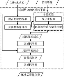
| [1] |
ZHU Bai, YE Yuanxin, ZHOU Liang, et al. Robust registration of aerial images and LiDAR data using spatial constraints and Gabor structural features[J]. ISPRS Journal of Photogrammetry and Remote Sensing, 2021, 181: 129-147.
|
| [2] |
JONASSEN V O, KJØRSVIK N S, GJEVESTAD J G O. Scalable hybrid adjustment of images and LiDAR point clouds[J]. ISPRS Journal of Photogrammetry and Remote Sensing, 2023, 202: 652-662.
|
| [3] |
ZHANG Yongjun, XIONG Xiaodong, WANG Mengqiu, et al. A fast aerial image matching method using airborne LiDAR point cloud and POS data[J]. Journal of Geodesy and Geoinformation Science, 2019, 2(1): 26-36.
|
| [4] |
ZHANG Yongjun, ZOU Siyuan, LIU Xinyi, et al. LiDAR-guided stereo matching with a spatial consistency constraint[J]. ISPRS Journal of Photogrammetry and Remote Sensing, 2022, 183: 164-177.
|
| [5] |
ZOU Siyuan, LIU Xinyi, HUANG Xu, et al. Edge-preserving stereo matching using LiDAR points and image line features[J]. IEEE Geoscience and Remote Sensing Letters, 2023, 20: 3239030.
|
| [6] |
ZHANG Lei, LI Xu, TANG Kaichen, et al. FS-Net: LiDAR-camera fusion with matched scale for 3D object detection in autonomous driving[J]. IEEE Transactions on Intelligent Transportation Systems, 2023, 24(11): 12154-12165.
|
| [7] |
ZHAO Lin, ZHOU Hui, ZHU Xinge, et al. LIF-seg: LiDAR and camera image fusion for 3D LiDAR semantic segmentation[J]. IEEE Transactions on Multimedia, 2024, 26: 1158-1168.
|
| [8] |
LI X, ZHANG X, NIU X, et al. Progress and achievements of multi-sensor fusion navigation in China during 2019—2023[J]. Journal of Geodesy and Geoinformation Science, 2023, 6(3): 102-114.
|
| [9] |
BALIC N, WEINACKER H, KOCH B. Generation of mosaiced digital true orthophotographs from multispectral and LiDAR data[J]. International Journal of Remote Sensing, 2007, 28(16): 3679-3688.
|
| [10] |
陈首彬. 激光LiDAR/视觉融合的SLAM(LV-SLAM)关键技术研究[J]. 测绘学报, 2023, 52(1): 169. DOI:.
doi: 10.11947/j.AGCS.2023.20210184
|
|
CHEN Shoubin. Research on SLAM based on LiDAR/visual fusion (LV-SLAM)[J]. Acta Geodaetica et Cartographica Sinica, 2023, 52(1): 169. DOI:.
doi: 10.11947/j.AGCS.2023.20210184
|
| [11] |
REN Siyu, ZENG Yiming, HOU Junhui, et al. CorrI2P: deep image-to-point cloud registration via dense correspondence[J]. IEEE Transactions on Circuits and Systems for Video Technology, 2023, 33(3): 1198-1208.
|
| [12] |
WANG Yanjun, LI Shaochun, WANG Mengjie, et al. A simple deep learning network for classification of 3D mobile LiDAR point clouds[J]. Journal of Geodesy and Geoinformation Science, 2021, 4(3): 49-59.
|
| [13] |
LI Jiaxin, HEE LEE G. DeepI2P: image-to-point cloud registration via deep classification[C]//Proceedings of 2021 IEEE/CVF Conference on Computer Vision and Pattern Recognition. Nashville: IEEE, 2021.
|
| [14] |
ESLAMI M, SAADATSERESHT M. A new tie plane-based method for fine registration of imagery and point cloud dataset[J]. Canadian Journal of Remote Sensing, 2020, 46(3): 295-312.
|
| [15] |
YANG Bisheng, CHEN Chi. Automatic registration of UAV-borne sequent images and LiDAR data[J]. ISPRS Journal of Photogrammetry and Remote Sensing, 2015, 101: 262-274.
|
| [16] |
PANDEY G, MCBRIDE J R, SAVARESE S, et al. Automatic extrinsic calibration of vision and LiDAR by maximizing mutual information[J]. Journal of Field Robotics, 2015, 32(5): 696-722.
|
| [17] |
SUN Shaohui, SAVALGGIO C. Complex building roof detection and strict description from LiDAR data and orthorectified aerial imagery[C]//Proceedings of 2012 IEEE International Geoscience and Remote Sensing Symposium. Munich: IEEE, 2012.
|
| [18] |
TEO T A, HUANG S H. Automatic co-registration of optical satellite images and airborne LiDAR data using relative and absolute orientations[J]. IEEE Journal of Selected Topics in Applied Earth Observations and Remote Sensing, 2013, 6(5): 2229-2237.
|
| [19] |
NAIMAEE R, SAADATSERESHT M, OMIDALIZARANDI M. Automatic extraction of control points from 3D LiDAR mobile mapping and UAV imagery for aerial triangulation[J]. ISPRS Annals of the Photogrammetry, Remote Sensing and Spatial Information Sciences, 2023,: 581-588.
|
| [20] |
BARSAI G, YILMAZ A, NAGARAJAN S, et al. Registration of images to LiDAR and GIS data without establishing explicit correspondences[J]. Photogrammetric Engineering & Remote Sensing, 2017, 83(10): 705-716.
|
| [21] |
ZITOVÁ B, FLUSSER J. Image registration methods: a survey[J]. Image and Vision Computing, 2003, 21(11): 977-1000.
|
| [22] |
WONG A, ORCHARD J. Efficient FFT-accelerated approach to invariant optical-LiDAR registration[J]. IEEE Transactions on Geoscience and Remote Sensing, 2008, 46(11): 3917-3925.
|
| [23] |
MASTIN A, KEPNER J, FISHER J. Automatic registration of LIDAR and optical images of urban scenes[C]//Proceedings of 2009 IEEE Conference on Computer Vision and Pattern Recognition. Miami: IEEE, 2009.
|
| [24] |
PARMEHR E G, FRASER C S, ZHANG C, et al. Automatic registration of optical imagery with 3D LiDAR data using statistical similarity[J]. ISPRS Journal of Photogrammetry and Remote Sensing, 2014, 88: 28-40.
|
| [25] |
BESL P J, MCKAY N D. Method for registration of 3D shapes[C]//Proceedings of 1992 Sensor Fusion IV: Control Paradigms and Data Structures. Boston: SPIE, 1992.
|
| [26] |
LI Jiayuan, HU Qingwu, AI Mingyao. RIFT: multi-modal image matching based on radiation-variation insensitive feature transform[J]. IEEE Transactions on Image Processing, 2020, 29: 3296-3310.
|
| [27] |
刘伟玉, 万一, 张永军, 等. 基于相位均匀卷积的LiDAR深度图与航空影像高效匹配方法[J]. 武汉大学学报(信息科学版), 2022, 47(8): 1309-1317.
|
|
LIU Weiyu, WAN Yi, ZHANG Yongjun, et al. An efficient matching method of LiDAR depth map and aerial image based on phase mean convolution[J]. Geomatics and Information Science of Wuhan University, 2022, 47(8): 1309-1317.
|
| [28] |
张永军, 洪玮辰, 万一. 利用距离变换模型进行卫星影像与激光点云精配准[J]. 武汉大学学报(信息科学版), 2023, 48(3): 339-348.
|
|
ZHANG Yongjun, HONG Weichen, WAN Yi. Precise registration of satellite images and laser point clouds using distance transformation model[J]. Geomatics and Information Science of Wuhan University, 2023, 48(3): 339-348.
|
| [29] |
WAN Y, ZHANG Y, WANG G, et al. Accurate registration of aerial images and als-point cloud via automated junction matching and planar constraints[J]. ISPRS Annals of the Photogrammetry, Remote Sensing and Spatial Information Sciences, 2020(2): 79-86.
|
| [30] |
HUANG Rongyong, ZHENG Shunyi, HU Kun. Registration of aerial optical images with LiDAR data using the closest point principle and collinearity equations[J]. Sensors, 2018, 18(6): 1770.
|
| [31] |
VON GIOI R G, JAKUBOWICZ J, MOREL J M, et al. LSD: a fast line segment detector with a false detection control[J]. IEEE Transactions on Pattern Analysis and Machine Intelligence, 2010, 32(4): 722-732.
|
| [32] |
张永军, 熊小东, 沈翔. 城区机载LiDAR数据与航空影像的自动配准[J]. 遥感学报, 2012, 16(3): 579-595.
|
|
ZHANG Yongjun, XIONG Xiaodong, SHEN Xiang. Automatic registration of urban aerial imagery with airborne LiDAR data[J]. Journal of Remote Sensing, 2012, 16(3): 579-595.
|
| [33] |
LI J, ZHANG Y, HU Q. Robust estimation in robot vision and photogrammetry: a new model and its applications[J]. ISPRS Annals of Photogrammetry, Remote Sensing and Spatial Information Sciences, 2021, 51(1): 137-144.
|


 ), 朱昌俊1, 邹思远1, 刘欣怡1, 毛庆洲1, 万一1,2(