


测绘学报 ›› 2026, Vol. 55 ›› Issue (2): 261-274.doi: 10.11947/j.AGCS.2026.20250363
路中1( ), 赵金奇1(), 牛玉芬2, 陈立权1, 樊茜佑1, 司锦钊3, 王子璇1, 高源1, 王帅1, 曲菲霏1, 时洪涛1, 闫世勇1, 师芸4, 赵争5
收稿日期:2025-09-04
修回日期:2025-12-09
出版日期:2026-03-13
发布日期:2026-03-13
通讯作者:
赵金奇
E-mail:zhonglu@cumt.edu.cn;masurq@cumt.edu.cn
作者简介:路中(1967—),男,教授,研究方向为SAR卫星传感器设计与论证、InSAR形变监测及地球物理解译。 E-mail:zhonglu@cumt.edu.cn
基金资助:
Zhong LU1(), Jinqi ZHAO1(), Yufen NIU2, Liquan CHEN1, Qianyou FAN1, Jinzhao SI3, Zixuan WANG1, Yuan GAO1, Shuai WANG1, Feifei QU1, Hongtao SHI1, Shiyong YAN1, Yun SHI4, Zheng ZHAO5
Received:2025-09-04
Revised:2025-12-09
Online:2026-03-13
Published:2026-03-13
Contact:
Jinqi ZHAO
E-mail:zhonglu@cumt.edu.cn;masurq@cumt.edu.cn
About author:LU Zhong (1967—), male, professor, majors in SAR satellite sensors development and verification, InSAR processing, deformation monitoring, and geophysical interpretation. E-mail: zhonglu@cumt.edu.cn
Supported by:摘要:
由美国国家航空航天局(NASA)与印度空间研究组织(ISRO)联合研制的合成孔径雷达(NISAR)卫星于2025年7月30日成功发射。凭借其大幅宽、高分辨率、左视成像与双频协同观测的优势,该卫星将显著增强固体地球、冰冻圈与生态系统等领域的观测能力;同时其开放的SAR/InSAR处理工具链与数据政策将大幅降低数据处理的专业门槛。为此,本文系统综述了NISAR卫星的特性,及其对全球地表形变观测任务的推动与创新:首先,解析NISAR卫星系统设计的理念;其次,详细阐述NISAR卫星对地观测的独特性,尤其是在形变监测方面的技术优势;最后,对不同类型地质灾害地表形变特征差异进行分析,总结NISAR卫星对各类灾害形变监测潜在的能力提升。
中图分类号:
路中, 赵金奇, 牛玉芬, 陈立权, 樊茜佑, 司锦钊, 王子璇, 高源, 王帅, 曲菲霏, 时洪涛, 闫世勇, 师芸, 赵争. NISAR卫星对地观测革新及其在地表形变监测中的应用[J]. 测绘学报, 2026, 55(2): 261-274.
Zhong LU, Jinqi ZHAO, Yufen NIU, Liquan CHEN, Qianyou FAN, Jinzhao SI, Zixuan WANG, Yuan GAO, Shuai WANG, Feifei QU, Hongtao SHI, Shiyong YAN, Yun SHI, Zheng ZHAO. The NISAR mission: innovations in earth observation and applications in surface deformation monitoring[J]. Acta Geodaetica et Cartographica Sinica, 2026, 55(2): 261-274.
表1
NISAR与Sentinel-1、Biomass卫星主要参数对比"
| 卫星 | 工作波段 | 极化方式 | 空间分辨率(距离向×方位向) | 幅宽 | 重访周期 | 轨道控制精度 | 设计寿命 | 成像视角 | 数据开放 | 数据产品 |
|---|---|---|---|---|---|---|---|---|---|---|
| NISAR | L波段(23.8 cm)、S波段(9.4 cm) | 单/双/全极化 | 3/6/12 m×7 m | 120~240 km | 12 d | 350 m | 3 a | 左视 | 是 | RSLC、RIFG、RUNW、GSLC、GUNW、GOFF |
| Sentinel-1 | C波段(5.6 cm) | 单/双极化 | 5 m×5 m(SM)、5 m×20 m(IW)、20 m×40 m(EW) | 80 km(SM)、250 km(IW)、400 km(EW) | 12 d(单星)、6 d(双星) | 60 m | >7 a | 右视 | 是 | SLC、GRD、NRB、ETAD |
| Biomass | P波段(约70 cm) | 全极化 | 50 m×8 m | 约50 km×3 | ≥3 d | — | 5 a | 右视 | 是 | SCS、DGM、STA |
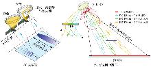
图1
SweepSAR工作模式"
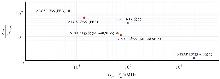
图2
电离层相位标准差与子频相位标准差的比值同子频中心频率之差关系"
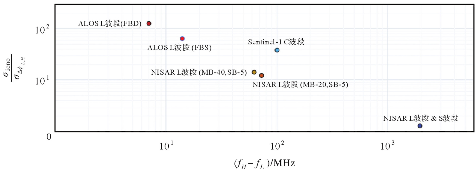
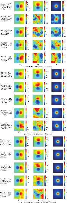
图3
左视与右视成像几何的InSAR LOS向观测组合用于推导地表三维形变场"

表2
不同InSAR LOS向观测组合所推导地表三维形变场与Mogi模型正演三维形变场在不同噪声水平下的均方根误差统计"
| LOS向 | Sentinel-1 | (升轨)+Sentinel-1(降轨)+ALOS-2(升轨) | Sentinel-1(升轨)+Sentinel-1(降轨)+NISAR(升轨) | Sentinel-1(升轨)+Sentinel-1(降轨)+NISAR(升轨)+NISAR(降轨) | ||||||||
|---|---|---|---|---|---|---|---|---|---|---|---|---|
| 1/20 | 1/10 | 1/5 | 1/3 | 1/20 | 1/10 | 1/5 | 1/3 | 1/20 | 1/10 | 1/5 | 1/3 | |
| EW | 0.3 | 0.7 | 1.2 | 1.5 | 0.3 | 0.6 | 1.3 | 1.6 | 0.2 | 0.5 | 0.7 | 1.5 |
| NS | 21.2 | 34.7 | 118.9 | 158.5 | 1.1 | 3.3 | 5.8 | 11.7 | 0.9 | 1.3 | 3.4 | 7.1 |
| U | 3.5 | 5.7 | 19.2 | 26.2 | 0.3 | 0.5 | 0.7 | 1.3 | 0.1 | 0.4 | 0.8 | 0.8 |
表3
不同灾害监测特点及NISAR的重要作用"
| 灾害类型 | 形变特性与InSAR监测挑战 | NISAR卫星的优势和作用 |
|---|---|---|
| 滑坡 | (1)空间尺度跨度大,既需要对单体滑坡进行精细表征,也要求对区域滑坡群开展系统性识别与评估。 (2)形变速率范围宽,每年数毫米的缓慢蠕变至每日米级剧滑。 (3)环境复杂,常受地形几何畸变、茂密植被影响,失相干严重。 (4)三维形变演变过程复杂。 | (1)兼顾大幅宽与高空间分辨率,能够同步实现区域尺度滑坡群的普查与重点区域单体滑坡的精细监测。 (2)长期稳定的时序观测数据,适用于缓慢蠕变到中等速率位移的形变监测;大梯度形变容纳能力,结合高时空分辨率,可显著增强对突发性滑坡和剧滑过程的捕捉能力。 (3)较强穿透能力,可有效减弱植被覆盖区域的失相干现象;电离层相位的高精度校正,能够减弱大气误差的干扰。 (4)联合其他右视SAR卫星构建观测网,可有效校正几何畸变;通过融合不同视角数据,可精确解算三维形变。 |
| 火山 | (1)演化过程时间长,通常经历岩浆补给、运移、喷发及喷后调整等多个阶段。 (2)环境复杂,常受地形几何畸变、茂密植被和季节性积雪覆盖等多源误差影响。 | (1)长期稳定的高时空分辨率观测数据,适用于捕捉火山完整的动态演化过程。 (2)较强穿透能力,能够有效减弱植被覆盖和季节性积雪引起的失相干现象;左视观测的补充,减少地形畸变影响;整体上,有利于精细捕捉非稳态形变信号。 |
| 构造 | (1)演化过程时间长,形变量级小。通常表现为长期、缓慢且持续的地壳形变,其活动速率低至毫米/年。 (2)影响范围常跨越数百甚至上千千米,呈现明显的区域尺度特征。 | (1)长期稳定的高时空分辨率观测数据,有助于揭示震间长期微弱的形变规律。 (2)大幅宽与高时间分辨率特性,能够高效获取广域的微小形变信号。 |
| 地震 | (1)同震形变场空间分布广,且近场形变梯度大。 (2)震后延伸至数年甚至数十年的震后松弛与震间应力积累,形成跨越从毫米级的微震前兆到米级的同震错动。 | (1)高空间分辨率和大梯度形变容纳能力,有利于获取更精确完整的近场大位移信号。 (2)长期稳定的高时间分辨率多星观测网络,能够快速捕捉震后瞬态演变及震间微小形变,有助于揭示地震多阶段、多机制耦合的复杂时空演化。 |
| 地面沉降 | (1)长期缓慢且持续的形变演化过程。 (2)影响范围多呈现区域性或更大空间尺度分布。 (3)环境复杂,大气误差影响严重,且众多区域受植被限制,监测点密度不足。 | (1)长期稳定的高时空分辨率观测数据,能够持续获取地面沉降演变特征。 (2)大宽幅与高空间分辨率特性,可同时满足广域和重点区域监测需求。 (3)更精确的电离层改正,可有效减弱大气误差的影响;较强的植被穿透能力与高空间分辨率,能够显著提高相干点的密度,有助于清晰刻画沉降边界与内部细节。 |
| 开采沉陷 | (1)空间范围小,形变梯度大,且形变场不连续;时间尺度变化剧烈,月尺度累积形变量可达米级。 (2)三维形变明显,最大水平位移可达沉降量的1/3左右。 | (1)高空间分辨率和大梯度形变容纳能力,可有效减弱相位解缠难度;高时间分辨率有助于提高沉陷盆地动态变化监测的可靠性,揭示开采扰动的传播机制与时空演化规律。 (2)结合现有SAR传感器,可通过多轨道、多角度协同观测解算三维形变场。 |
| 冻土 | (1)积雪及土壤湿度变化剧烈,造成相位观测散射机理复杂。 (2)热喀斯特地貌发育受到土壤湿度以及温度等多种因素约束,时空演化特征不一,要求高时空分辨率数据观测与建模。 | (1)较强的穿透能力,能够显著抑制干雪层对雷达信号的干扰,提升冻融形变提取的可靠性。 (2)高空间分辨率观测能够结合局部排水条件对不同热喀斯特地貌进行精细化监测,理解其与外部环境之间的耦合关系。 (3)进一步结合现有SAR传感器,可实现高重访观测,进而构建更先进的形变模型,有助于深入解译冻融过程的水-热-力学变化过程。 |
| 冰川 | (1)移动速度较快,常超出InSAR可监测范围。 (2)环境复杂,高山常受地形几何畸变、大气延迟、积雪覆盖影响,失相干严重。 (3)数据成本及时空分辨率限制,影响冰川物质变化估算的准确性。 (4)全球观测数据不全,尤其高纬度地区的冰川研究受限。 | (1)长波信号有助于提升InSAR技术用于快速形变场的监测能力。 (2)较强穿透力,能够有效减弱积雪引起的失相干现象。 (3)高分辨率全极化L、S观测数据融合,有效提升地形、地物刻画精细程度,提高冰川区获取地形动态变化的潜力与可靠性。 (4)左视成像能缓解地形畸变现象,并补足当前在轨SAR观测系统在南极及其他高纬度区域的观测盲区。 |
| [1] | 邓云凯, 禹卫东, 张衡, 等. 未来星载SAR技术发展趋势[J]. 雷达学报, 2020, 9(1): 1-33. |
| DENG Yunkai, YU Weidong, ZHANG Heng, et al. Forthcoming spaceborne SAR development[J]. Journal of Radars, 2020, 9(1): 1-33. | |
| [2] |
李振洪, 朱武, 余琛, 等. 影像大地测量学发展现状与趋势[J]. 测绘学报, 2023, 52(11): 1805-1834. DOI: .
doi: 10.11947/j.AGCS.2023.20230003 |
|
LI Zhenhong, ZHU Wu, YU Chen, et al. Development status and trends of imaging geodesy[J]. Acta Geodaetica et Cartographica Sinica, 2023, 52(11): 1805-1834. DOI: .
doi: 10.11947/j.AGCS.2023.20230003 |
|
| [3] |
朱建军, 李志伟, 胡俊. InSAR变形监测方法与研究进展[J]. 测绘学报, 2017, 46(10): 1717-1733. DOI: .
doi: 10.11947/j.AGCS.2017.20170350 |
|
ZHU Jianjun, LI Zhiwei, HU Jun. Research progress and methods of InSAR for deformation monitoring[J]. Acta Geodaetica et Cartographica Sinica, 2017, 46(10): 1717-1733. DOI: .
doi: 10.11947/j.AGCS.2017.20170350 |
|
| [4] | TSOKAS A, RYSZ M, PARDALOS P M, et al. SAR data applications in earth observation: an overview[J]. Expert Systems with Applications, 2022, 205: 117342. |
| [5] | TORRES R, SNOEIJ P, GEUDTNER D, et al. GMES Sentinel-1 mission[J]. Remote Sensing of Environment, 2012, 120: 9-24. |
| [6] | SHIMADA M, ITOH T, MOTOOKA T, et al. New global forest/non-forest maps from ALOS PALSAR data (2007—2010)[J]. Remote Sensing of Environment, 2014, 155: 13-31. |
| [7] | 杨元喜, 王建荣, 楼良盛, 等. 航天测绘发展现状与展望[J]. 中国空间科学技术, 2022, 42(3): 1-9. |
| YANG Yuanxi, WANG Jianrong, LOU Liangsheng, et al. Development status and prospect of satellite-based surveying[J]. Chinese Space Science and Technology, 2022, 42(3): 1-9. | |
| [8] |
张庆君. 高分三号卫星总体设计与关键技术[J]. 测绘学报, 2017, 46(3): 269-277. DOI: .
doi: 10.11947/j.AGCS.2017.20170049 |
|
ZHANG Qingjun. System design and key technologies of the GF-3 satellite[J]. Acta Geodaetica et Cartographica Sinica, 2017, 46(3): 269-277. DOI: .
doi: 10.11947/j.AGCS.2017.20170049 |
|
| [9] |
宋鑫友, 张磊, 李涛, 等. 陆探一号干涉SAR在轨测试阶段基线精化与DEM精度分析[J]. 测绘学报, 2024, 53(10): 1920-1929. DOI: .
doi: 10.11947/j.AGCS.2024.20230540 |
|
SONG Xinyou, ZHANG Lei, LI Tao, et al. Baseline refinement and DEM accuracy analysis during the in-orbit test phase of LT-1 SAR[J]. Acta Geodaetica et Cartographica Sinica, 2024, 53(10): 1920-1929. DOI: .
doi: 10.11947/j.AGCS.2024.20230540 |
|
| [10] | ZHAO Jinqi, ZHANG Ming, ZHOU Zhonghuai, et al. CFFormer: a cross-fusion transformer framework for the semantic segmentation of multisource remote sensing images[J]. IEEE Transactions on Geoscience and Remote Sensing, 2025, 63: 1-17. |
| [11] | ZHU Xiaoxiang, MONTAZERI S, ALI M, et al. Deep learning meets SAR: concepts, models, pitfalls, and perspectives[J]. IEEE Geoscience and Remote Sensing Magazine, 2021, 9(4): 143-172. |
| [12] | QUEGAN S, LE TOAN T, CHAVE J, et al. The European Space Agency BIOMASS mission: measuring forest above-ground biomass from space[J]. Remote Sensing of Environment, 2019, 227: 44-60. |
| [13] | NASA. NASA-ISRO satellite lifts off to track earth's changing surfaces[EB/OL]. [2025-09-01]. https://www.nasa.gov/news-release/nasa-isro-satellite-lifts-off-to-track-earths-changing-surfaces/. |
| [14] | NASA Jet Propulsion Laboratory. NASA-ISRO SAR (NISAR) mission science users' handbook[EB/OL]. [2025-09-02]. https://nisar.jpl.nasa.gov/system/documents/files/26_NISAR_FINAL_9-6-19.pdf. |
| [15] | CUMMING I G, WONG F H. Digital processing of synthetic aperture radar data: algorithms and implementation[J]. Artech House, 2005, 1(3): 108-110. |
| [16] | HOFFMAN J P, VEILLEUX L, PERKOVIC D, et al. Digital calibration of TR modules for real-time digital beamforming SweepSAR architectures[C]//Proceedings of 2012 IEEE Aerospace Conference. Big Sky: IEEE, 2012: 1-8. |
| [17] | SHARMA S, TRIPATHI S, RAY A, et al. Establishment of SAR calibration site at Antarctica: Pre-NISAR calibration activity[J]. Advances in Space Research, 2022, 69(4): 1715-1725. |
| [18] | ROSEN P A, BAWDEN G W, BARELA P, et al. The NASA-ISRO SAR mission: a summary[J]. IEEE Geoscience and Remote Sensing Magazine, 2025, 13(2): 8-34. |
| [19] | HU Jun, LI Zhiwei, DING Xiaoli, et al. Resolving three-dimensional surface displacements from InSAR measurements: a review[J]. Earth-Science Reviews, 2014, 133: 1-17. |
| [20] | ISCE-framework. ISCE2: InSAR scientific computing environment[EB/OL]. [2025-09-01]. https://github.com/isce-framework/isce2. |
| [21] | ASF. HyP3: hybrid pluggable processing pipeline[EB/OL]. [2025-09-01]. https://github.com/ASFHyP3. |
| [22] |
李振洪, 朱武, 余琛, 等. 雷达影像地表形变干涉测量的机遇、挑战与展望[J]. 测绘学报, 2022, 51(7): 1485-1519. DOI: .
doi: 10.11947/j.AGCS.2022.20220224 |
|
LI Zhenhong, ZHU Wu, YU Chen, et al. Interferometric synthetic aperture radar for deformation mapping: opportunities, challenges and the outlook[J]. Acta Geodaetica et Cartographica Sinica, 2022, 51(7): 1485-1519. DOI: .
doi: 10.11947/j.AGCS.2022.20220224 |
|
| [23] | LÜ Zongsen, ZHANG Zhimin, FAN Huaitao, et al. A two-stage approach for TSNB and ITWB RFI mitigation in P-and L-band SAR data[J]. IEEE Transactions on Aerospace and Electronic Systems, 2024, 60(2): 1450-1470. |
| [24] | LU Zhong, WICKS C, KWOUN O, et al. Surface deformation associated with the March 1996 earthquake swarm at Akutan Island, Alaska, revealed by C-band ERS and L-band JERS radar interferometry[J]. Canadian Journal of Remote Sensing, 2005, 31(1): 7-20. |
| [25] | LU Zhong, DZURISIN D. InSAR imaging of Aleutian volcanoes[M]. Berlin: Springer, 2014: 87-345. |
| [26] | HANSSEN R F. Radar interferometry: data interpretation and error analysis[M]. Dordrecht: Springer Netherlands, 2001. |
| [27] | FATTAHI H, SIMONS M, AGRAM P. InSAR time-series estimation of the ionospheric phase delay: an extension of the split range-spectrum technique[J]. IEEE Transactions on Geoscience and Remote Sensing, 2017, 55(10): 5984-5996. |
| [28] | SAMSONOV S, DILLE A, DEWITTE O, et al. Satellite interferometry for mapping surface deformation time series in one, two and three dimensions: a new method illustrated on a slow-moving landslide[J]. Engineering Geology, 2020, 266: 105471. |
| [29] |
何秀凤, 高壮, 肖儒雅, 等. InSAR与北斗/GNSS综合方法监测地表形变研究现状与展望[J]. 测绘学报, 2022, 51(7): 1338-1355. DOI: .
doi: 10.11947/j.AGCS.2022.20220132 |
|
HE Xiufeng, GAO Zhuang, XIAO Ruya, et al. Application and prospect of the integration of InSAR and BDS/GNSS for land surface deformation monitoring[J]. Acta Geodaetica et Cartographica Sinica, 2022, 51(7): 1338-1355. DOI: .
doi: 10.11947/j.AGCS.2022.20220132 |
|
| [30] | WANG Chisheng, CHANG Ling, WANG Xiangsheng, et al. Interferometric synthetic aperture radar statistical inference in deformation measurement and geophysical inversion: a review[J]. IEEE Geoscience and Remote Sensing Magazine, 2024, 12(1): 8-35. |
| [31] |
张勤, 赵超英, 陈雪蓉. 多源遥感地质灾害早期识别技术进展与发展趋势[J]. 测绘学报, 2022, 51(6): 885-896. DOI: .
doi: 10.11947/j.AGCS.2022.20220132 |
|
ZHANG Qin, ZHAO Chaoying, CHEN Xuerong. Technical progress and development trend of geological hazards early identification with multi-source remote sensing[J]. Acta Geodaetica et Cartographica Sinica, 2022, 51(6): 885-896. DOI: .
doi: 10.11947/j.AGCS.2022.20220132 |
|
| [32] | 葛大庆, 戴可人, 郭兆成, 等. 重大地质灾害隐患早期识别中综合遥感应用的思考与建议[J]. 武汉大学学报(信息科学版), 2019, 44(7): 949-956. |
| GE Daqing, DAI Keren, GUO Zhaocheng, et al. Early identification of serious geological hazards with integrated remote sensing technologies: thoughts and recommendations[J]. Geomatics and Information Science of Wuhan University, 2019, 44(7): 949-956. | |
| [33] | CASAGLI N, INTRIERI E, TOFANI V, et al. Landslide detection, monitoring and prediction with remote-sensing techniques[J]. Nature Reviews Earth & Environment, 2023, 4(1): 51-64. |
| [34] | MA Peifeng, CHEN Li, YU Chang, et al. Dynamic landslide susceptibility mapping over last three decades to uncover variations in landslide causation in subtropical urban mountainous areas[J]. Remote Sensing of Environment, 2025, 326: 114800. |
| [35] | HU Xie, BÜRGMANN R, LU Zhong, et al. Mobility, thickness, and hydraulic diffusivity of the slow-moving Monroe landslide in California revealed by L-band satellite radar interferometry[J]. Journal of Geophysical Research: Solid Earth, 2019, 124(7): 7504-7518. |
| [36] | KIM J, COE J A, LU Zhong, et al. Spaceborne InSAR mapping of landslides and subsidence in rapidly deglaciating terrain, Glacier Bay National Park and Preserve and vicinity, Alaska and British Columbia[J]. Remote Sensing of Environment, 2022, 281: 113231. |
| [37] | 许强, 郭朋瑜. 滑坡变形机理与特征研究[J]. 中国科学:技术科学, 2025, 55(7): 1222-1234. |
| XU Qiang, GUO Pengyu. Mechanisms and characteristics of landslide deformation[J]. Scientia Sinica (Technologica), 2025, 55(7): 1222-1234. | |
| [38] | 廖明生, 董杰, 李梦华, 等. 雷达遥感滑坡隐患识别与形变监测[J]. 遥感学报, 2021, 25(1): 332-341. |
| LIAO Mingsheng, DONG Jie, LI Menghua, et al. Radar remote sensing for potential landslides detection and deformation monitoring[J]. Journal of Remote Sensing, 2021, 25(1): 332-341. | |
| [39] | ZHANG Shuangcheng, JU Ziheng, NIU Yufen, et al. Multi-source SAR-based surface deformation analysis of edgecumbe volcano, Alaska, and its relationship with earthquakes[J]. Remote Sensing, 2025, 17(7): 1307. |
| [40] | 许文斌, 罗兴军, 朱建军, 等. InSAR火山形变监测与参数反演研究进展[J]. 武汉大学学报(信息科学版), 2023, 48(10): 1632-1642. |
| XU Wenbin, LUO Xingjun, ZHU Jianjun, et al. Review of volcano deformation monitoring and modeling with InSAR[J]. Geomatics and Information Science of Wuhan University, 2023, 48(10): 1632-1642. | |
| [41] | PENG Mimi, MOTAGH M, LU Zhong, et al. Characterization and prediction of InSAR-derived ground motion with ICA-assisted LSTM model[J]. Remote Sensing of Environment, 2024, 301: 113923. |
| [42] | ZHANG Lei, DING Xiaoli, LU Zhong. Ground settlement monitoring based on temporarily coherent points between two SAR acquisitions[J]. ISPRS Journal of Photogrammetry and Remote Sensing, 2011, 66(1): 146-152. |
| [43] | COSTANTINI M, FERRETTI A, MINATI F, et al. Analysis of surface deformations over the whole Italian territory by interferometric processing of ERS, Envisat and COSMO-SkyMed radar data[J]. Remote Sensing of Environment, 2017, 202: 250-275. |
| [44] | QU Feifei, LU Zhong, KIM J, et al. Mapping and characterizing land deformation during 2007—2011 over the Gulf Coast by L-band InSAR[J]. Remote Sensing of Environment, 2023, 284: 113342. |
| [45] | BAI Lin, JIANG Liming, ZHAO Yong, et al. Quantifying the influence of long-term overexploitation on deep groundwater resources across Cangzhou in the North China Plain using InSAR measurements[J]. Journal of Hydrology, 2022, 605: 127368. |
| [46] | 刘传金, 季灵运, 朱良玉, 等. 联合InSAR和GNSS构建青藏高原千米分辨率三维地壳形变场[J]. 中国科学:地球科学, 2024, 54(6): 1845-1862. |
| LIU Chuanjin, JI Lingyun, ZHU Liangyu, et al. Kilometer-resolution three-dimensional crustal deformation of Qinghai-Xizang Plateau from InSAR and GNSS[J]. Science China Earth Sciences, 2024, 54(6): 1845-1862. | |
| [47] | 许才军, 王宇飞, 贺克锋. 川滇地区地壳形变动力学模式数值模拟研究综述[J]. 武汉大学学报(信息科学版), 2024, 49(11): 2003-2015. |
| XU Caijun, WANG Yufei, HE Kefeng. Review on the study of numerical simulation of crustal deformation dynamic models in Sichuan-Yunnan region[J]. Geomatics and Information Science of Wuhan University, 2024, 49(11): 2003-2015. | |
| [48] | ZHAO Dezheng, QU Chunyan, SHAN Xinjian, et al. An updated fault coupling model along major block-bounding faults on the eastern and northeastern Tibetan Plateau from a stress-constrained inversion of GPS and InSAR data[J]. Journal of Geophysical Research: Solid Earth, 2024, 129(4): e2023JB028483. |
| [49] | LI Yanchuan, SHAN Xinjian, QU Chunyan, et al. Earthquake potential across the North-South seismic belt of China[J]. Science Bulletin, 2024, 69(2): 179-182. |
| [50] | YANG Jiuyuan, XU Caijun, WEN Yangmao, et al. Complex coseismic and postseismic faulting during the 2021 northern Thessaly (Greece) earthquake sequence illuminated by InSAR observations[J]. Geophysical Research Letters, 2022, 49(8): e2022GL098545. |
| [51] | 何国清, 杨伦, 凌赓娣, 等. 矿山开采沉陷学[M]. 徐州: 中国矿业大学出版社, 1991. |
| HE Guoqing, YANG Lun, LING Gengdi, et al. Mine subsidence science[M]. Xuzhou: China University of Mining and Technology Press, 1991. | |
| [52] |
汪云甲. 矿区生态扰动监测研究进展与展望[J]. 测绘学报, 2017, 46(10): 1705-1716. DOI: .
doi: 10.11947/j.AGCS.2017.20170358 |
|
WANG Yunjia. Research progress and prospect on ecological disturbance monitoring in mining area[J]. Acta Geodaetica et Cartographica Sinica, 2017, 46(10): 1705-1716. DOI: .
doi: 10.11947/j.AGCS.2017.20170358 |
|
| [53] | YANG Zefa, LI Zhiwei, ZHU Jianjun, et al. Use of SAR/InSAR in mining deformation monitoring, parameter inversion, and forward predictions: a review[J]. IEEE Geoscience and Remote Sensing Magazine, 2020, 8(1): 71-90. |
| [54] | 张廷军. 全球多年冻土与气候变化研究进展[J]. 第四纪研究, 2012, 32(1): 27-38. |
| ZHANG Tingjun. Progress in global permafrost and climate change studies[J]. Quaternary Sciences, 2012, 32(1): 27-38. | |
| [55] | SI Jinzhao, ZHANG Shuangcheng, NIU Yufen, et al. The surface deformation of permafrost and active layer thickness in the upper reaches of the Black River basin, revealed by InSAR observations and independent component analysis[J]. Science ofthe Total Environment, 2024, 951: 175667. |
| [56] | CHEN Jie, WU Tonghua, ZOU Defu, et al. Magnitudes and patterns of large-scale permafrost ground deformation revealed by Sentinel-1 InSAR on the central Qinghai-Tibet Plateau[J]. Remote Sensing of Environment, 2022, 268: 112778. |
| [57] | 秦大河. 冰冻圈科学概论[M]. 北京: 科学出版社, 2017. |
| QIN Dahe. Introduction to cryosphere science[M]. Beijing: Science Press, 2017. | |
| [58] | YI Shuhua, WANG Xiaoyun, QIN Yu, et al. Responses of Alpine grassland on Qinghai-Tibetan Plateau to climate warming and permafrost degradation: a modeling perspective[J]. Environmental Research Letters, 2014, 9(7): 074014. |
| [59] |
吴立新, 李佳, 苗则朗, 等. 冰川流域孕灾环境及灾害的天空地协同智能监测模式与方向[J]. 测绘学报, 2021, 50(8): 1109-1121. DOI: .
doi: 10.11947/j.AGCS.2021.20210107 |
|
WU Lixin, LI Jia, MIAO Zelang, et al. Pattern and directions of spaceborne-airborne-ground collaborated intelligent monitoring on the geo-hazards developing environment and disasters in glacial basin[J]. Acta Geodaetica et Cartographica Sinica, 2021, 50(8): 1109-1121. DOI: .
doi: 10.11947/j.AGCS.2021.20210107 |
|
| [60] | ZHOU Yushan, LI Xin, ZHENG Donghai, et al. Evolution of geodetic mass balance over the largest lake-terminating glacier in the Tibetan Plateau with a revised radar penetration depth based on multi-source high-resolution satellite data[J]. Remote Sensing of Environment, 2022, 275: 113029. |
| [61] | YANG Liye, LU Zhong, ZHAO Chaoying, et al. Studying mass movement sources and potential glacial lake outburst flood at Jiongpu Co, southeastern Tibet, using multiple remote sensing methods and HEC-RAS model[J]. Journal of Geophysical Research: Earth Surface, 2025, 130(7): e2024JF008067. |
| [62] | 刘国祥, 张波, 张瑞, 等. 联合卫星SAR和地基SAR的海螺沟冰川动态变化及次生滑坡灾害监测[J]. 武汉大学学报(信息科学版), 2019, 44(7): 980-995. |
| LIU Guoxiang, ZHANG Bo, ZHANG Rui, et al. Monitoring dynamics of Hailuogou glacier and the secondary landslide disasters based on combination of satellite SAR and ground-based SAR[J]. Geomatics and Information Science of Wuhan University, 2019, 44(7): 980-995. | |
| [63] | JIANG Mi, HOOPER A, TIAN Xin, et al. Delineation of built-up land change from SAR stack by analysing the coefficient of variation[J]. ISPRS Journal of Photogrammetry and Remote Sensing, 2020, 169: 93-108. |
| [64] | FAN Wenzhi, WANG Teng, BARBOT S, et al. Weak asthenosphere beneath the Eurasian interior inferred from Aral Sea desiccation[J]. Nature Geoscience, 2025, 18(4): 351-357. |
| [65] | XIONG Zhiqiang, FENG Guangcai, YANG Zefa, et al. Nationwide mapping and characterization of land subsidence in the United States using InSAR[J]. Remote Sensing of Environment, 2026, 333: 115134. |
| [66] | DAI Keren, CHEN Youdong, XU Qiang, et al. A functional model for determining maximum detectable deformation gradients of InSAR considering the topography in mountainous areas[J]. IEEE Transactions on Geoscience and Remote Sensing, 2023, 61: 5211211. |
| [67] | QU Feifei, ZHANG Qin, NIU Yufen, et al. Mapping the recent vertical crustal deformation of the Weihe Basin (China) using Sentinel-1 and ALOS-2 ScanSAR imagery[J]. Remote Sensing, 2022, 14(13): 3182. |
| [68] | CHEN Liquan, ZHAO Chaoying, LI Bin, et al. Deformation monitoring and failure mode research of mining-induced Jianshanying landslide in karst mountain area, China with ALOS/PALSAR-2 images[J]. Landslides, 2021, 18(8): 2739-2750. |
| [69] | 许强, 董秀军, 李为乐. 基于天-空-地一体化的重大地质灾害隐患早期识别与监测预警[J]. 武汉大学学报(信息科学版), 2019, 44(7): 957-966. |
| XU Qiang, DONG Xiujun, LI Weile. Integrated space-air-ground early detection, monitoring and warning system for potential catastrophic geohazards[J]. Geomatics and Information Science of Wuhan University, 2019, 44(7): 957-966. | |
| [70] | 崔鹏, 贾洋, 苏凤环, 等. 青藏高原自然灾害发育现状与未来关注的科学问题[J]. 中国科学院院刊, 2017, 32(9): 985-992. |
| CUI Peng, JIA Yang, SU Fenghuan, et al. Natural hazards in Tibetan Plateau and key issue for feature research[J]. Bulletin of Chinese Academy of Sciences, 2017, 32(9): 985-992. | |
| [71] | GAO Zhuang, HE Xiufeng, MA Zhangfeng, et al. Distributed scatterer interferometry for fast decorrelation scenarios based on sparsity regularization[J]. IEEE Transactions on Geoscience and Remote Sensing, 2024, 62: 5209614. |
| [72] | 戴可人, 许强, 邓晋, 等. 滑坡隐患InSAR广域识别研究综述[J]. 武汉大学学报(信息科学版), 2025, 50(8): 1469-1482. |
| DAI Keren, XU Qiang, DENG Jin, et al. Review on large-scale identification of potential landslides with InSAR[J]. Geomatics and Information Science of Wuhan University, 2025, 50(8): 1469-1482. | |
| [73] | SHAO Yi, JIANG Liming, YANG Bo, et al. A sparse convolution method to reduce the atmospheric phase screen of SAR interferometry in the coastal region[J]. IEEE Transactions on Geoscience and Remote Sensing, 2024, 62: 5223317. |
| [1] | 李鹏, 白建博, 李振洪, 王厚杰. 融合多轨道TS-InSAR的广域海岸带地面沉降监测及成因解析——以山东省为例[J]. 测绘学报, 2025, 54(7): 1178-1191. |
| [2] | 杜钊锋, 李国鹏, 刘站科, 尚夏明, 康胜军, 王晓强. 国家重点沉降区域多监测手段综合分析[J]. 测绘学报, 2025, 54(3): 481-492. |
| [3] | 陈海禄, 沈云中. GNSS辅助下的InSAR对流层延迟垂直分层与湍流分量联合改正模型[J]. 测绘学报, 2025, 54(10): 1786-1797. |
| [4] | 江利明, 邵益, 周志伟, 马培峰, 王腾. 智能化InSAR数据处理研究进展、挑战与展望[J]. 测绘学报, 2024, 53(6): 1037-1056. |
| [5] | 周苍海, 田镇, 石震, 托坎哈衣那尔·. 时序InSAR与GNSS联合约束下的亚东-谷露断裂运动特征[J]. 测绘学报, 2024, 53(5): 933-945. |
| [6] | 朱珺, 彭葳, 付海强, 欧蔓, 雷缮诚, 张石平. 观测信息不足条件下TanDEM-X InSAR的大范围林下地形反演[J]. 测绘学报, 2024, 53(5): 959-966. |
| [7] | 高延东, 贾义琨, 李世金, 陈宇, 李怀展, 郑南山, 张书毕. InSAR相位解缠最大流/最小割权值改进算法[J]. 测绘学报, 2024, 53(4): 644-652. |
| [8] | 何毅, 杨旺, 朱庆. 基于R2AU-Net的InSAR相位解缠方法[J]. 测绘学报, 2024, 53(3): 435-449. |
| [9] | 王媛, 徐华平, 李春升, 曾国兵, 刘爱芳, 葛仕奇. 星载分布式SAR双频乒乓模式测高精度分析[J]. 测绘学报, 2024, 53(3): 463-472. |
| [10] | 岳佳伟, 黄其欢, 刘辉, 马张烽. 离散优化框架下的多基线InSAR相位解缠方法[J]. 测绘学报, 2024, 53(3): 473-481. |
| [11] | 宋鑫友, 张磊, 李涛, 雷宝成, 宋瑞庆. 陆探一号干涉SAR在轨测试阶段基线精化与DEM精度分析[J]. 测绘学报, 2024, 53(10): 1920-1929. |
| [12] | 许兵, 朱焱, 李志伟, 易辉伟, 胡妙文, 陈琦, 韩焜, 杜洵. 国产卫星时序InSAR形变监测精度分析[J]. 测绘学报, 2024, 53(10): 1930-1941. |
| [13] | 林东方, 姚宜斌, 郑敦勇, 廖孟光, 谢建. 利用均方误差相对变化规律确定正则化参数及其在PolInSAR测量反演中的应用[J]. 测绘学报, 2023, 52(9): 1480-1491. |
| [14] | 李涛, 李超, 沈翔, 江利明, 汪汉胜, 李刚, 林珲. 双站InSAR和ICESat-2测高相结合的西昆仑山近20年冰川物质平衡变化监测[J]. 测绘学报, 2023, 52(6): 917-931. |
| [15] | 张玉鹏, 张永红, 吴宏安, 刘青豪, 魏钜杰, 康永辉. 融合卫星与地面数据研究京津冀地区弹性骨架储水系数[J]. 测绘学报, 2023, 52(4): 660-669. |
| 阅读次数 | ||||||
|
全文 |
|
|||||
|
摘要 |
|
|||||