


测绘学报 ›› 2025, Vol. 54 ›› Issue (10): 1786-1797.doi: 10.11947/j.AGCS.2025.20250124
陈海禄( ), 沈云中()
收稿日期:2025-03-28
修回日期:2025-07-09
出版日期:2025-11-14
发布日期:2025-11-14
通讯作者:
沈云中
E-mail:2210929@tongji.edu.cn;yzshen@tongji.edu.cn
作者简介:陈海禄(1996—),男,博士生,研究方向为InSAR数据处理。E-mail:2210929@tongji.edu.cn
基金资助:
Hailu CHEN(), Yunzhong SHEN()
Received:2025-03-28
Revised:2025-07-09
Online:2025-11-14
Published:2025-11-14
Contact:
Yunzhong SHEN
E-mail:2210929@tongji.edu.cn;yzshen@tongji.edu.cn
About author:CHEN Hailu (1996—), male, PhD candidate, majors in InSAR data processing. E-mail: 2210929@tongji.edu.cn
Supported by:摘要:
GNSS基准站观测的对流层延迟量常用于改正InSAR对流层延迟误差,其实质是将GNSS点位观测到的延迟量推估(内插)至未测点位。传统方法只考虑湍流分量的空间相关特性,通过函数模型或随机模型建立干涉图误差改正模型,忽略垂直分层影响。本文提出兼顾垂直分层与湍流影响的InSAR干涉图误差联合改正模型,分别采用高程相关函数模型和随机模型建模垂直分层与湍流,并通过最小二乘配置同时估计确定性垂直分层模型参数与GNSS观测点位处的湍流分量,最后将二者推估至干涉图其他未测点位。应用本文方法处理美国南加州地区71景Sentinel-1数据,结果表明,本文方法可将70幅最短时间基线干涉图的平均标准差从4.7 rad降低至1.4 rad,改正效果优于GACOS(平均标准差下降至2.7 rad)、线性模型(平均标准差下降至4.1 rad)、GInSAR(平均标准差下降至2.9 rad)和LSC-GInSAR方法(平均标准差下降至1.8 rad)。此外,获得的线性形变速率揭示出试验区长波形变特征,与GNSS观测吻合良好(相关系数为0.67),验证了本文方法可有效改正InSAR干涉图的中长波长对流层延迟,适用于提取大尺度地表形变信号。
中图分类号:
陈海禄, 沈云中. GNSS辅助下的InSAR对流层延迟垂直分层与湍流分量联合改正模型[J]. 测绘学报, 2025, 54(10): 1786-1797.
Hailu CHEN, Yunzhong SHEN. GNSS-assisted InSAR tropospheric delay correction model incorporating vertical stratification and turbulent components[J]. Acta Geodaetica et Cartographica Sinica, 2025, 54(10): 1786-1797.
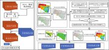
图1
本文方法流程和干涉图改正量计算"


图2
研究区域与数据覆盖情况"

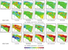
图3
两幅干涉图对流层延迟改正前后比较"


图4
70幅短时间基线干涉图改正前后标准差比较"
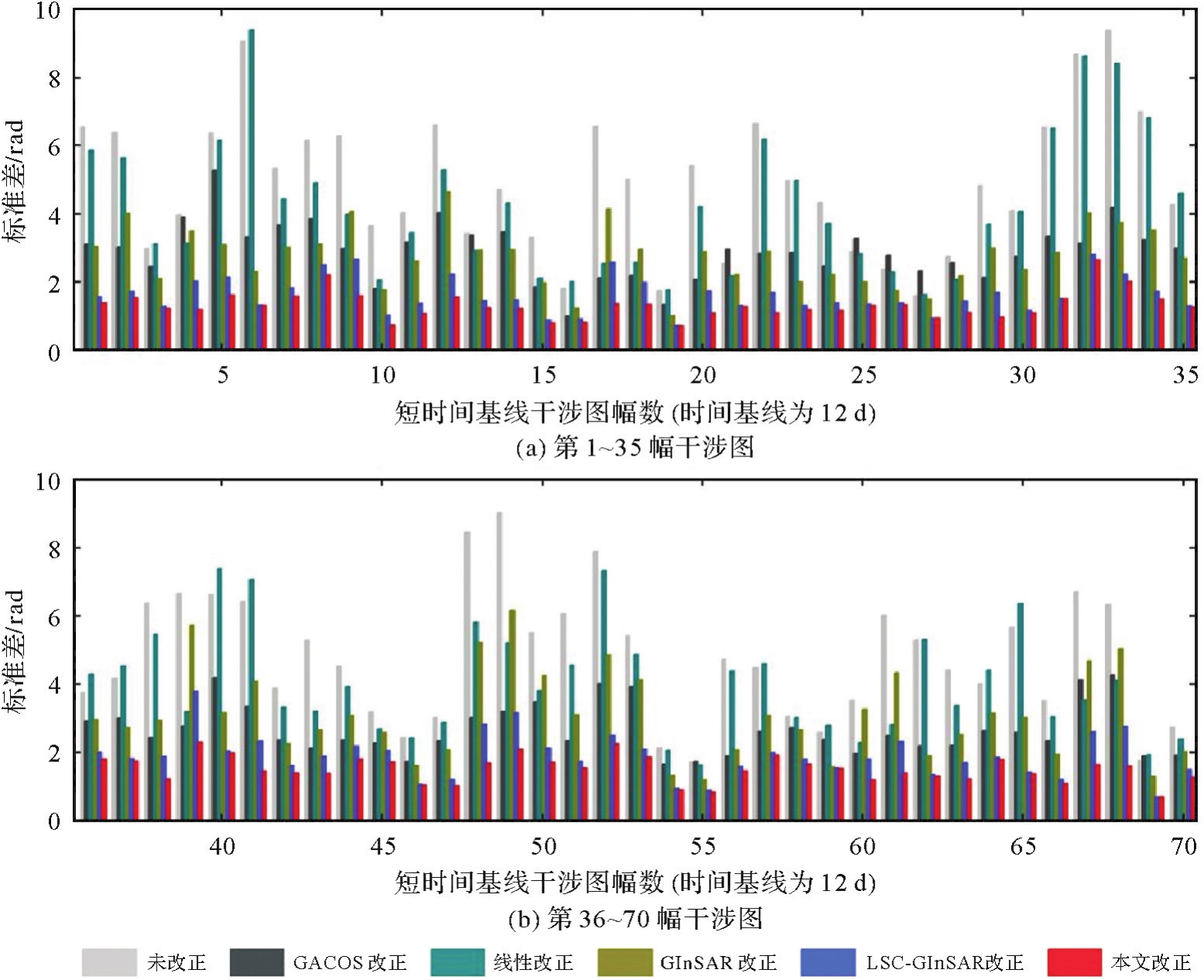

图5
改正前后线性形变速率(圆圈表示GNSS观测)"
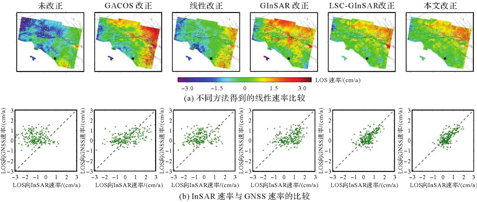

图6
改正前后线性形变速率标准差"
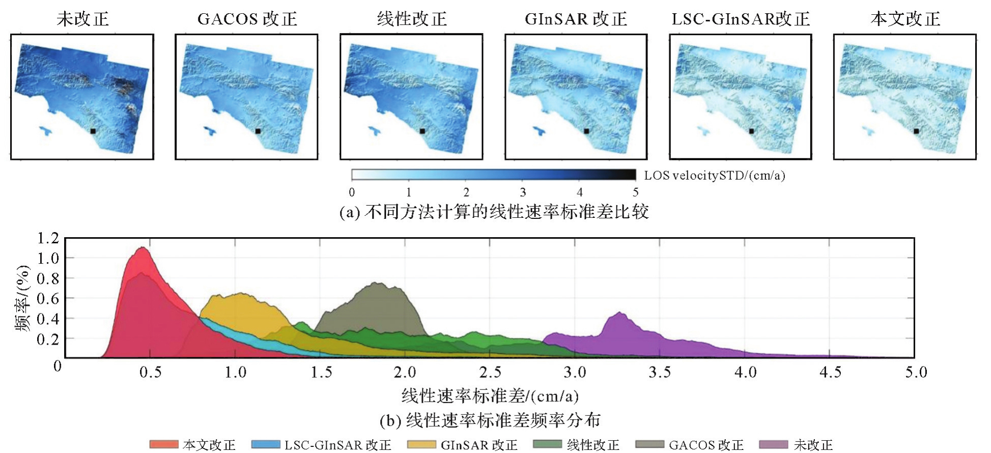
表1
基于海拔高度的GNSS站点分组"
| 高度/m | 类型 |
|---|---|
| [0,200) | 低海拔 |
| [200,800) | 中海拔 |
| [800,∞) | 高海拔 |
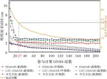
图7
不同GNSS站点参与计算的改正效果"

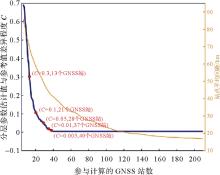
图8
不同GNSS站点参与计算垂直分层参数与参考值差异程度"
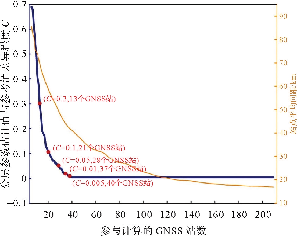
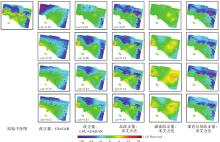
图9
使用不同数量GNSS站估计对流层延迟"


图10
图9中未参与计算的GNSS检核站观测值与估计值的残差"
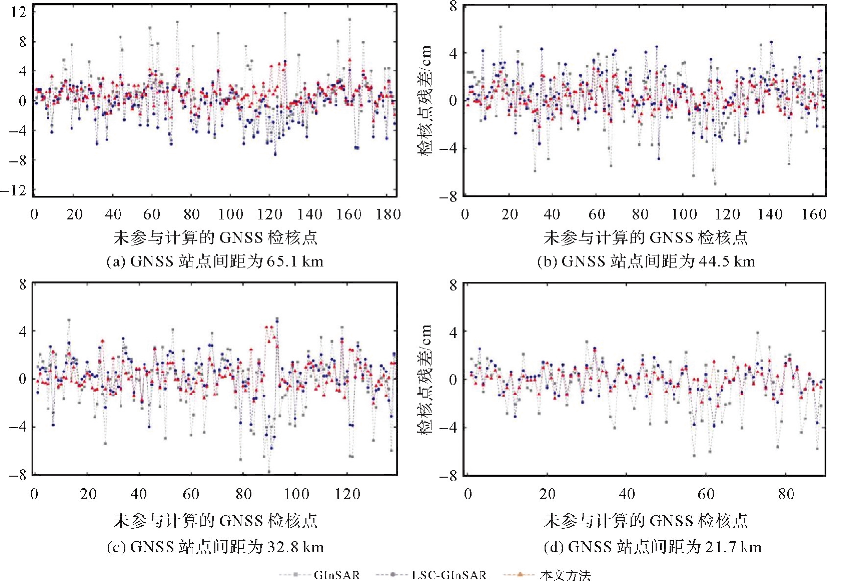
表2
图9中未参与计算的GNSS检核站残差RMSE"
| GNSS站点间距/km | GInSAR/cm | LSC-GInSAR/cm | 本文方法/cm |
|---|---|---|---|
| 65.1 | 3.4 | 2.5 | 1.7 |
| 44.5 | 2.3 | 1.9 | 1.3 |
| 32.8 | 2.5 | 1.8 | 1.1 |
| 21.7 | 2.3 | 1.3 | 0.7 |
| [1] | 李振洪, 宋闯, 余琛, 等. 卫星雷达遥感在滑坡灾害探测和监测中的应用:挑战与对策[J]. 武汉大学学报(信息科学版), 2019, 44(7): 967-979. |
| LI Zhenhong, SONG Chuang, YU Chen, et al. Application of satellite radar remote sensing to landslide detection and monitoring: challenges and solutions[J]. Geomatics and Information Science of Wuhan University, 2019, 44(7): 967-979. | |
| [2] | LI Zhenhong, YU Chen, XIAO Ruya, et al. Entering a new era of InSAR: advanced techniques and emerging applications[J]. Journal of Geodesy and Geoinformation Science, 2022, 5(1): 168-172. |
| [3] |
刘计洪, 胡俊, 李志伟, 等. InSAR三维同震地表形变监测:窗口优化的SM-VCE算法[J]. 测绘学报, 2021, 50(9): 1222-1239. DOI: .
doi: 10.11947/j.AGCS.2021.20200610 |
|
LIU Jihong, HU Jun, LI Zhiwei, et al. Estimation of 3D coseismic deformation with InSAR: an improved SM-VCE method by window optimization[J]. Acta Geodaetica et Cartographica Sinica, 2021, 50(9): 1222-1239. DOI: .
doi: 10.11947/j.AGCS.2021.20200610 |
|
| [4] |
朱建军, 杨泽发, 李志伟. InSAR矿区地表三维形变监测与预计研究进展[J]. 测绘学报, 2019, 48(2): 135-144. DOI: .
doi: 10.11947/j.AGCS.2019.20180188 |
|
ZHU Jianjun, YANG Zefa, LI Zhiwei. Recent progress in retrieving and predicting mining-induced 3D displace-ments using InSAR[J]. Acta Geodaetica et Cartographica Sinica, 2019, 48(2): 135-144. DOI: .
doi: 10.11947/j.AGCS.2019.20180188 |
|
| [5] | ZHANG Lei, LU Zhong, DING Xiaoli, et al. Mapping ground surface deformation using temporarily coherent point SAR interferometry: application to Los Angeles basin[J]. Remote Sensing of Environment, 2012, 117: 429-439. |
| [6] | ZHAO Chaoying, LU Zhong, ZHANG Qin, et al. Large-area landslide detection and monitoring with ALOS/PALSAR imagery data over Northern California and Southern Oregon, USA[J]. Remote Sensing of Environment, 2012, 124: 348-359. |
| [7] | LI Zhiwei, CAO Yunmeng, WEI Jianchao, et al. Time-series InSAR ground deformation monitoring: atmospheric delay modeling and estimating[J]. Earth-Science Reviews, 2019, 192: 258-284. |
| [8] | DOIN M P, LASSERRE C, PELTZER G, et al. Corrections of stratified tropospheric delays in SAR interferometry: validation with global atmospheric models[J]. Journal of Applied Geophysics, 2009, 69(1): 35-50. |
| [9] | JOLIVET R, AGRAM P S, LIN N Y, et al. Improving InSAR geodesy using global atmospheric models[J]. Journal of Geophysical Research: Solid Earth, 2014, 119(3): 2324-2341. |
| [10] | YU Chen, LI Zhenhong, PENNA N T, et al. Generic atmospheric correction model for interferometric synthetic aperture radar observations[J]. Journal of Geophysical Research: Solid Earth, 2018, 123(10): 9202-9222. |
| [11] | HANSSEN R F. Radar Interferometry: data interpretation and error analysis[M]. London: Springer Science & Business Media, 2001. |
| [12] | CHEN Hailu, SHEN Yunzhong. LSC-GInSAR: a GNSS-enhanced InSAR approach by using least squares collocation open access[J]. Geophysical Journal International, 2023, 236(1): 49-61. |
| [13] | ZHANG Xuesong, LI Zhenhong, LIU Zhenjiang. Reduction of atmospheric effects on InSAR observations through incorporation of GACOS and PCA into small baseline subset InSAR[J]. IEEE Transactions on Geoscience and Remote Sensing, 2023, 61: 5209115. |
| [14] | LOHMAN R B, SIMONS M. Some thoughts on the use of InSAR data to constrain models of surface deformation: noise structure and data downsampling[J]. Geochemistry, Geophysics, Geosystems, 2005, 6: Q01007. |
| [15] | BEKAERT D P S, HOOPER A, WRIGHT T J. A spatially variable power law tropospheric correction technique for InSAR data[J]. Journal of Geophysical Research: Solid Earth, 2015, 120(2): 1345-1356. |
| [16] | LIANG Hongyu, ZHANG Lei, DING Xiaoli, et al. Toward mitigating stratified tropospheric delays in multitemporal InSAR: a quadtree aided joint model[J]. IEEE Transactions on Geoscience and Remote Sensing, 2019, 57(1): 291-303. |
| [17] | HOOPER A. A multi-temporal InSAR method incorporating both persistent scatterer and small baseline approaches[J]. Geophysical Research Letters, 2008, 35: L16302. |
| [18] | LIANG Hongyu, ZHANG Lei, LU Zhong, et al. Correction of spatially varying stratified atmospheric delays in multitemporal InSAR[J]. Remote Sensing of Environment, 2023, 285: 113382. |
| [19] | WANG Shuai, LU Zhong, WANG Bin, et al. A phase-based InSAR tropospheric correction method for interseismic deformation based on short-period interferograms[J]. IEEE Transactions on Geoscience and Remote Sensing, 2023, 61: 5212318. |
| [20] | LIU Jihong, HU Jun, BÜRGMANN R, et al. Mitigating atmospheric delays in InSAR time series: the DetrendInSAR method and its validation[J]. Journal of Geophysical Research: Solid Earth, 2024, 129(5): e2024JB028920. |
| [21] | CHEN Hailu, SHEN Yunzhong, ZHANG Lei, et al. Mitigation of tropospheric turbulent delays in InSAR time series by incorporating a stochastic process[J]. ISPRS Journal of Photogrammetry and Remote Sensing, 2025, 222: 186-203. |
| [22] | LI Z W, XU W B, FENG G C, et al. Correcting atmospheric effects on InSAR with MERIS water vapour data and elevation-dependent interpolation model[J]. Geophysical Journal International, 2012, 189(2): 898-910. |
| [23] | LI Zhenhong, MULLER J P, CROSS P, et al. Interferometric synthetic aperture radar (InSAR) atmospheric correction: GPS, moderate resolution imaging spectroradiometer (MODIS), and InSAR integration[J]. Journal of Geophysical Research: Solid Earth, 2005, 110(B3): B03410. |
| [24] | CAO Yunmeng, JÓNSSON S, LI Zhiwei. Advanced InSAR tropospheric corrections from global atmospheric models that incorporate spatial stochastic properties of the troposphere[J]. Journal of Geophysical Research: Solid Earth, 2021, 126(5): e2020JB020952. |
| [25] | YU Chen, PENNA N T, LI Zhenhong. Generation of real-time mode high-resolution water vapor fields from GPS observations[J]. Journal of Geophysical Research: Atmospheres, 2017, 122(3): 2008-2025. |
| [26] | NEELY W R, BORSA A A, SILVERII F. GInSAR: a cGPS correction for enhanced InSAR time series[J]. IEEE Transactions on Geoscience and Remote Sensing, 2020, 58(1): 136-146. |
| [27] | LIU Yuhao, WANG Guoquan, YU Xiao, et al. Sentinel-1 InSAR and GPS-integrated long-term and seasonal subsidence monitoring in Houston, Texas, USA[J]. Remote Sensing, 2022, 14(23): 6184. |
| [28] | GUNS K, XU Xiaohua, BOCK Y, et al. GNSS-corrected InSAR displacement time-series spanning the 2019 Ridgecrest, CA earthquakes[J]. Geophysical Journal International, 2022, 230(2): 1358-1373. |
| [29] | LIU Ning, DAI Wujiao, SANTERRE R, et al. High spatio-temporal resolution deformation time series with the fusion of InSAR and GNSS data using spatio-temporal random effect model[J]. IEEE Transactions on Geoscience and Remote Sensing, 2019, 57(1): 364-380. |
| [30] | GE L, HAN S, RIZOS C. The double interpolation and double prediction (DIDP) approach for InSAR and GPS integration[J]. International Archives of Photogrammetry and Remote Sensing, 2000, 33(B2): 205-212. |
| [31] | 占文俊, 李志伟, 韦建超, 等. 一种InSAR大气相位建模与估计方法[J]. 地球物理学报, 2015, 58(7): 2320-2329. |
| ZHAN Wenjun, LI Zhiwei, WEI Jianchao, et al. A strategy for modeling and estimating atmospheric phase of SAR interferogram[J]. Chinese Journal of Geophysics, 2015, 58(7): 2320-2329. | |
| [32] | KRAUP T A. Contribution to the mathematical foundation of physical geodesy[M]//mathematical foundation of geodesy. Berlin: Springer, 2006: 29-90. |
| [33] | YANG Y, ZENG A, ZHANG J. Adaptive collocation with application in height system transformation[J]. Journal of Geodesy, 2009, 83(5): 403-410. |
| [34] | ROSEN P A, GURROLA E M, SACCO G F, et al. The InSAR scientific computing environment[C]//Proceedings of 2012 European Conference on Synthetic Aperture Radar. Hangzhou: IEEE, 2012. |
| [35] | GOLDSTEIN R M, WERNER C L. Radar interferogram filtering for geophysical applications[J]. Geophysical Research Letters, 1998, 25(21): 4035-4038. |
| [36] | CHEN C W, ZEBKER H A. Two-dimensional phase unwrapping with use of statistical models for cost functions in nonlinear optimization[J]. Journal of the Optical Society of America, 2001, 18(2): 338. |
| [37] | FATTAHI H, AMELUNG F. DEM error correction in InSAR time series[J]. IEEE Transactions on Geoscience and Remote Sensing, 2013, 51(7): 4249-4259. |
| [38] |
宋鑫友, 张磊, 李涛, 等. 陆探一号干涉SAR在轨测试阶段基线精化与DEM精度分析[J]. 测绘学报, 2024, 53(10): 1920-1929. DOI: .
doi: 10.11947/j.AGCS.2024.20230540 |
|
SONG Xinyou, ZHANG Lei, LI Tao, et al. Baseline refinement and DEM accuracy analysis during the in-orbit test phase of LT-1SAR[J]. Acta Geodaetica et Cartographica Sinica, 2024, 53(10): 1920-1929. DOI: .
doi: 10.11947/j.AGCS.2024.20230540 |
|
| [39] | ZHANG Yunjun, FATTAHI H, AMELUNG F. Small baseline InSAR time series analysis: unwrapping error correction and noise reduction[J]. Computers & Geosciences, 2019, 133: 104331. |
| [40] | MILBERT D. Solid: solid earth tide[EB/OL]. [2024-10-15]. http://geodesyworld.github.io/SOFTS/solid.html. |
| [41] | DABBERDT W F, SHELLHORN R A. On the optimal spatial sampling of atmospheric data[J]. Journal of Applied Meteorology, 1973, 12(1), 34-44. |
| [1] | 路中, 赵金奇, 牛玉芬, 陈立权, 樊茜佑, 司锦钊, 王子璇, 高源, 王帅, 曲菲霏, 时洪涛, 闫世勇, 师芸, 赵争. NISAR卫星对地观测革新及其在地表形变监测中的应用[J]. 测绘学报, 2026, 55(2): 261-274. |
| [2] | 李鹏, 白建博, 李振洪, 王厚杰. 融合多轨道TS-InSAR的广域海岸带地面沉降监测及成因解析——以山东省为例[J]. 测绘学报, 2025, 54(7): 1178-1191. |
| [3] | 赵庆志, 常璐璐, 姚宜斌, 李浩杰. 一种联合GNSS和气象数据的水文干旱指数构建方法[J]. 测绘学报, 2025, 54(7): 1192-1205. |
| [4] | 赵庆志, 蒋朵朵, 郭宏武, 李祖锋, 刘晨, 姚宜斌. GNSS水汽层析关键参量普适性确定方法[J]. 测绘学报, 2025, 54(3): 410-421. |
| [5] | 杜钊锋, 李国鹏, 刘站科, 尚夏明, 康胜军, 王晓强. 国家重点沉降区域多监测手段综合分析[J]. 测绘学报, 2025, 54(3): 481-492. |
| [6] | 江利明, 邵益, 周志伟, 马培峰, 王腾. 智能化InSAR数据处理研究进展、挑战与展望[J]. 测绘学报, 2024, 53(6): 1037-1056. |
| [7] | 周苍海, 田镇, 石震, 托坎哈衣那尔·. 时序InSAR与GNSS联合约束下的亚东-谷露断裂运动特征[J]. 测绘学报, 2024, 53(5): 933-945. |
| [8] | 朱珺, 彭葳, 付海强, 欧蔓, 雷缮诚, 张石平. 观测信息不足条件下TanDEM-X InSAR的大范围林下地形反演[J]. 测绘学报, 2024, 53(5): 959-966. |
| [9] | 罗亦泳, 吴大卫. 基于GPS TEC的2022年1月15日汤加火山喷发激起的电离层行扰分析[J]. 测绘学报, 2024, 53(4): 629-643. |
| [10] | 高延东, 贾义琨, 李世金, 陈宇, 李怀展, 郑南山, 张书毕. InSAR相位解缠最大流/最小割权值改进算法[J]. 测绘学报, 2024, 53(4): 644-652. |
| [11] | 何毅, 杨旺, 朱庆. 基于R2AU-Net的InSAR相位解缠方法[J]. 测绘学报, 2024, 53(3): 435-449. |
| [12] | 王媛, 徐华平, 李春升, 曾国兵, 刘爱芳, 葛仕奇. 星载分布式SAR双频乒乓模式测高精度分析[J]. 测绘学报, 2024, 53(3): 463-472. |
| [13] | 岳佳伟, 黄其欢, 刘辉, 马张烽. 离散优化框架下的多基线InSAR相位解缠方法[J]. 测绘学报, 2024, 53(3): 473-481. |
| [14] | 杨玲, 朱金成, 孙楠, 喻杨康, 沈云中, 李博峰. GNSS高级接收机自主完好性监测随机模型精化[J]. 测绘学报, 2024, 53(2): 286-295. |
| [15] | 宋鑫友, 张磊, 李涛, 雷宝成, 宋瑞庆. 陆探一号干涉SAR在轨测试阶段基线精化与DEM精度分析[J]. 测绘学报, 2024, 53(10): 1920-1929. |
| 阅读次数 | ||||||
|
全文 |
|
|||||
|
摘要 |
|
|||||