| [1] |
LECUN Y, BENGIO Y, HINTON G. Deep learning[J]. Nature, 2015, 521(7553): 436-444.
|
| [2] |
HINTON G E, SALAKHUTDINOV R R. Reducing the dimensionality of data with neural networks[J]. Science, 2006, 313(5786): 504-507.
|
| [3] |
LIU Li, OUYANG Wanli, WANG Xiaogang, et al. Deep learning for generic object detection: a survey[J]. International Journal of Computer Vision, 2020, 128(2): 261-318.
|
| [4] |
张兵, 高连如, 李嘉鑫, 等. 高/多光谱遥感图像超分辨率融合研究进展与展望[J]. 测绘学报, 2023, 52(7): 1074-1089. DOI: .
doi: 10.11947/j.AGCS.2023.20220499
|
|
ZHANG Bing, GAO Lianru, LI Jiaxin, et al. Advances and prospects in hyperspectral and multispectral remote sensing image super-resolution fusion[J]. Acta Geodaetica et Cartographica Sinica, 2023, 52(7): 1074-1089. DOI: .
doi: 10.11947/j.AGCS.2023.20220499
|
| [5] |
李德仁, 张良培, 夏桂松. 遥感大数据自动分析与数据挖掘[J]. 测绘学报, 2014, 43(12): 1211-1216.
|
|
LI Deren, ZHANG Liangpei, XIA Guisong. Automatic analysis and mining of remote sensing big data[J]. Acta Geodaetica et Cartographica Sinica, 2014, 43(12): 1211-1216.
|
| [6] |
BLASCHKE T. Object based image analysis for remote sensing[J]. ISPRS Journal of Photogrammetry and Remote Sensing, 2010, 65(1): 2-16.
|
| [7] |
陈军, 赵仁亮. GIS空间关系的基本问题与研究进展[J]. 测绘学报, 1999, 28(2): 95-102.
|
|
CHEN Jun, ZHAO Renliang. Spatial relations in GIS: a survey on its key issues and research progress[J]. Acta Geodaetica et Cartographic Sinica, 1999, 28(2): 95-102.
|
| [8] |
尤淑撑, 刘顺喜, 李小文, 等. 基于空间约束关系的土地利用/覆被遥感分类方法研究[J]. 农业工程学报, 2005, 21(9): 51-55.
|
|
YOU Shucheng, LIU Shunxi, LI Xiaowen, et al. Land-use/land-cover classification method under spatial constraint[J]. Transactions of the Chinese Society of Agricultural Engineering, 2005, 21(9): 51-55.
|
| [9] |
赵红蕊, 阎广建, 邓小炼, 等. 一种简单加入空间关系的实用图像分类方法[J]. 遥感学报, 2003, 7(5): 358-363.
|
|
ZHAO Hongrui, YAN Guangjian, DENG Xiaolian, et al. A classification method based on spatial information[J]. Journal of Remote Sensing, 2003, 7(5): 358-363.
|
| [10] |
舒宁. 关于遥感影像处理分析的理论与方法之若干问题[J]. 武汉大学学报(信息科学版), 2007, 32(11): 1007-1010, 1015.
|
|
SHU Ning. Aspects of the theories and methodologies for remote sensed image processing and analysis[J]. Geomatics and Information Science of Wuhan University, 2007, 32(11): 1007-1010, 1015.
|
| [11] |
胡圣武, 王宏涛. 空间关系的研究进展[J]. 测绘科学, 2007, 32(1): 153-156, 159, 166.
|
|
HU Shengwu, WANG Hongtao. Recent research of spatial relation[J]. Science of Surveying and Mapping, 2007, 32(1): 153-156, 159, 166.
|
| [12] |
吕可枫, 张永生, 于英, 等. 语义信息与地理配准相结合的实例目标定位[J]. 测绘学报, 2023, 52(8): 1375-1386. DOI: .
doi: 10.11947/j.AGCS.2023.20220008
|
|
LÜ Kefeng, ZHANG Yongsheng, YU Ying, et al. Instance object localization based on semantic information and geo-registration[J]. Acta Geodaetica et Cartographica Sinica, 2023, 52(8): 1375-1386. DOI: .
doi: 10.11947/j.AGCS.2023.20220008
|
| [13] |
CUI Wei, WANG Fei, HE Xin, et al. Multi-scale semantic segmentation and spatial relationship recognition of remote sensing images based on an attention model[J]. Remote Sensing, 2019, 11(9): 1044.
|
| [14] |
王骁, 钱海忠, 何海威, 等. 顾及邻域居民地群组相似性的道路网匹配方法[J]. 测绘学报, 2016, 45(1): 103-111. DOI: .
doi: 10.11947/j.AGCS.2016.20140588
|
|
WANG Xiao, QIAN Haizhong, HE Haiwei, et al. Matching method for road networks considering the similarity of the neighborhood habitation cluster[J]. Acta Geodaetica et Cartographica Sinica, 2016, 45(1): 103-111. DOI: .
doi: 10.11947/j.AGCS.2016.20140588
|
| [15] |
MUFFORD J T, HILL D J, FLOOD N J, et al. Use of unmanned aerial vehicles (UAVs) and photogrammetric image analysis to quantify spatial proximity in beef cattle[J]. Journal of Unmanned Vehicle Systems, 2019, 7(3): 194-206.
|
| [16] |
ZHENG Z, ZHONG Y, WANG J, et al. Foreground-aware relation network for geospatial object segmentation in high spatial resolution remote sensing imagery[C]//Proceedings of 2020 IEEE/CVF Conference on Computer Vision and Pattern Recognition. Berlin: IEEE, 2020.
|
| [17] |
刘万增, 陈杭, 任加新, 等. 基于混合智能的街景影像知识提取方法[J]. 测绘学报, 2024, 53(9): 1817-1828. DOI: .
doi: 10.11947/j.AGCS.2024.20220720
|
|
LIU Wanzeng, CHEN Hang, REN Jiaxin, et al. Research on knowledge extraction from street scene images based on hybrid intelligence[J]. Acta Geodaetica et Cartographica Sinica, 2024, 53(9): 1817-1828. DOI: .
doi: 10.11947/j.AGCS.2024.20220720
|
| [18] |
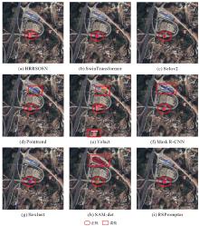
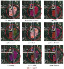
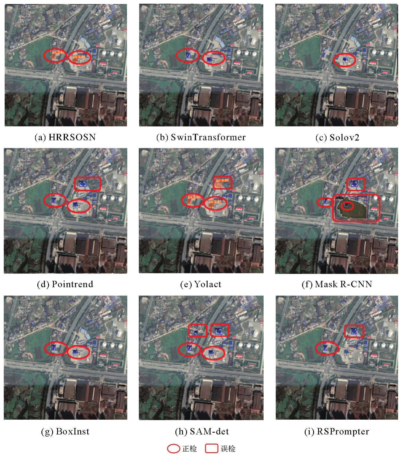
XIA Liegang, SU Yishao, LIU Ruiyan, et al. HRRSODN: high-resolution remote sensing object detection network fusion of road-adjacent relationships[J]. Geocarto International, 2023, 38(1): 213-221.
|
| [19] |
LI Ke, WAN Gang, CHENG Gong, et al. Object detection in optical remote sensing images: a survey and a new benchmark[J]. ISPRS Journal of Photogrammetry and Remote Sensing, 2020, 159: 296-307.
|
| [20] |
HE K, GKIOXARI G, DOLLÁR P, et al. Mask R-CNN[C]//Proceedings of 2017 IEEE International Conference on Computer Vision. Berlin: Springer, 2017.
|
| [21] |
BOLYA D, ZHOU Chong, XIAO Fanyi, et al. YOLACT: real-time instance segmentation[C]//Proceedings of 2019 IEEE/CVF International Conference on Computer Vision. Seoul: IEEE, 2019: 9156-9165.
|
| [22] |
WANG X, ZHANG R, KONG T, et al. Solov2: dynamic and fast instance segmentation[J]. Advances in Neural Information Processing Systems, 2020, 33: 17721-17732.
|
| [23] |
TIAN Zhi, SHEN Chunhua, WANG Xinlong, et al. BoxInst: high-performance instance segmentation with box annotations[C]//Proceedings of 2021 IEEE/CVF Conference on Computer Vision and Pattern Recognition. Nashville: IEEE, 2021: 5439-5448.
|
| [24] |
KIRILLOV A, WU Y, HE K, GIRSHICK R. Pointrend: image segmentation as rendering[C]//Proceedings of 2020 IEEE/CVF Conference on Computer Vision and Pattern Recognition. New York: IEEE, 2020.
|
| [25] |
VASWANI A, SHAZEER N, PARMAR N, et al. Attention is all you need[J]. Advances in Neural Information Processing Systems, 2017, 30: 657-661.
|
| [26] |
LIU Z, LIN Y, CAO Y, et al. SwinTransformer: hierarchical vision transformer using shifted windows[C]//Proceedings of 2021 IEEE/CVF International Conference on Computer Vision. New York: IEEE, 2021.
|
| [27] |
CHEN Keyan, LIU Chenyang, CHEN Hao, et al. RSPrompter: learning to prompt for remote sensing instance segmentation based on visual foundation model[J]. IEEE Transactions on Geoscience and Remote Sensing, 2024, 62: 1-17.
|


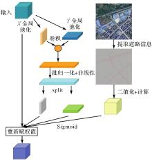
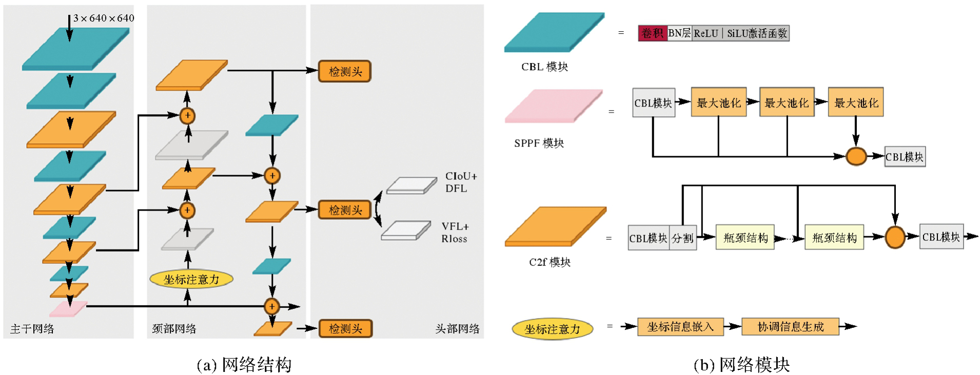
 ), 苏一少1, 骆剑承2,3, 胡晓东4, 夏列钢1,5(