


测绘学报 ›› 2026, Vol. 55 ›› Issue (4): 632-646.doi: 10.11947/j.AGCS.2026.20250412
高二涛1,2,3( ), 刘静1, 李淑瑾4, 周国清1,2(), 付波霖1,2,3, 李淑娴1
收稿日期:2025-10-19
修回日期:2026-03-25
出版日期:2026-05-11
发布日期:2026-05-11
通讯作者:
周国清
E-mail:gaoertao@glut.edu.cn;gzhou@glut.edu.cn
作者简介:高二涛(1991—),男,博士,副教授,研究方向为海岸带湿地遥感。 E-mail:gaoertao@glut.edu.cn
基金资助:
Ertao GAO1,2,3(), Jing LIU1, Shujin LI4, Guoqing ZHOU1,2(), Bolin FU1,2,3, Shuxian LI1
Received:2025-10-19
Revised:2026-03-25
Online:2026-05-11
Published:2026-05-11
Contact:
Guoqing ZHOU
E-mail:gaoertao@glut.edu.cn;gzhou@glut.edu.cn
About author:GAO Ertao (1991—), male, PhD, associate professor, majors in coastal wetland remote sensing. E-mail: gaoertao@glut.edu.cn
Supported by:摘要:
潮滩地处海陆交互作用的过渡地带,在维持海岸生态系统健康、蓝碳固存等方面发挥着不可替代的作用。在全球海平面上升、人类活动加剧等背景下,潮滩的时空分布、地表形变等亟须得到有效的监测及分析。本文以我国北部湾茅尾海海岸带为研究区,综合利用2015—2023年的Sentine-l2影像、低潮位Sentine-l1影像,结合海平面变化、降水量、水文变化等多源数据,开展了以下研究:①基于Google Earth Engine(GEE)云平台,利用时序Sentine-l2影像,结合最大光谱指数合成算法(MSIC)和大津算法(OTSU),构建了一种潮滩识别方法,准确提取了研究区潮滩的分布。结果发现,茅尾海地区潮滩面积由2016年的19.98 km2减少到2023年的15.80 km2,减少幅度为20.9%,土地利用的类型由潮滩向红树林、建设用地等转换。②构建了一种利用部分永久稳定散射体(PS)参与小基线集干涉测量技术(SBAS-InSAR)的“PS+SBAS-InSAR”形变提取方法,监测了潮滩的形变信息。结果发现,2015—2023年间,潮滩地表形变速率介于-54.72~41.71 mm/a之间。最大沉降地区位于红树湾,累计达-308.21 mm,最大抬升地区位于康熙岭,累计达到311.90 mm。茅尾海潮滩呈现不均匀形变变化,整体以微弱的抬升为主。其中,尖山河道两岸和红树湾呈现沉降,而康熙岭和尖山西北部呈现抬升,龙门七十二径东西两岸呈现不规则抬升和沉降。③综合多源数据分析发现,降水量、水文运动、海平面上升、红树林变化是潮滩地表形变的主导因子,且海平面上升与潮滩地表形变呈负相关。其中降水量、极端天气的影响具有季节性,而红树林、海平面上升和近海养殖的影响是长期的。
中图分类号:
高二涛, 刘静, 李淑瑾, 周国清, 付波霖, 李淑娴. 光学遥感与SAR协同的茅尾海潮滩多维时空演变监测与分析[J]. 测绘学报, 2026, 55(4): 632-646.
Ertao GAO, Jing LIU, Shujin LI, Guoqing ZHOU, Bolin FU, Shuxian LI. Multi-dimensional spatiotemporal monitoring and analysis of tidal flats in the Maowei Sea using integrated optical remote sensing and SAR[J]. Acta Geodaetica et Cartographica Sinica, 2026, 55(4): 632-646.
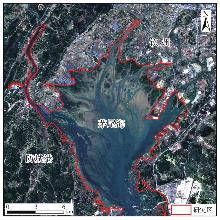
图1
研究区位置"
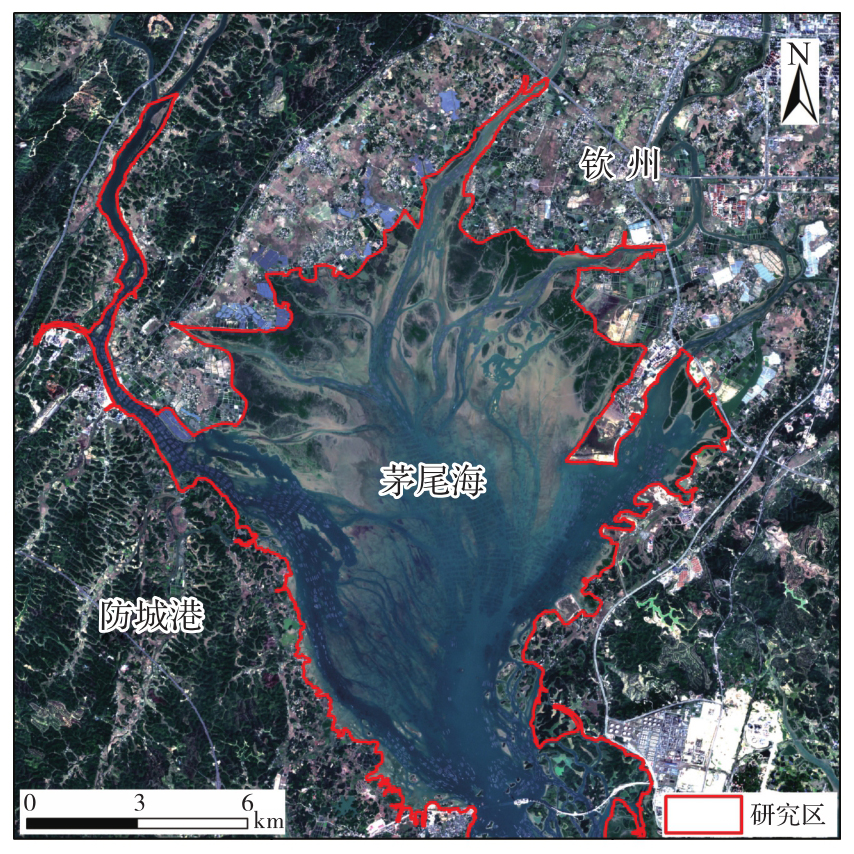
表1
Sentinel-1/Sentinel-2影像获取信息"
| 卫星 | 影像类型 | 获取年份 | 数量 | |
|---|---|---|---|---|
| Sentinel-1 | Sentinel-2 | |||
| Sentinel-1/Sentinel-2 | SAR/多光谱 | 2015 | 5 | 0 |
| 2016 | 8 | 7 | ||
| 2017 | 12 | 8 | ||
| 2018 | 12 | 14 | ||
| 2019 | 12 | 12 | ||
| 2020 | 12 | 13 | ||
| 2021 | 12 | 14 | ||
| 2022 | 11 | 17 | ||
| 2023 | 11 | 11 | ||
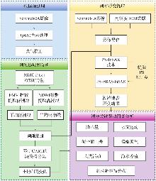
图2
技术流程"
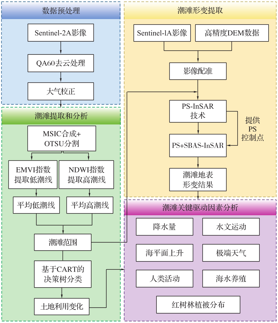
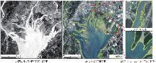
图3
EMVI计算的低潮结果"

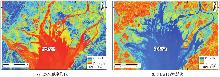
图4
基于MSIC算法最大值合成影像"
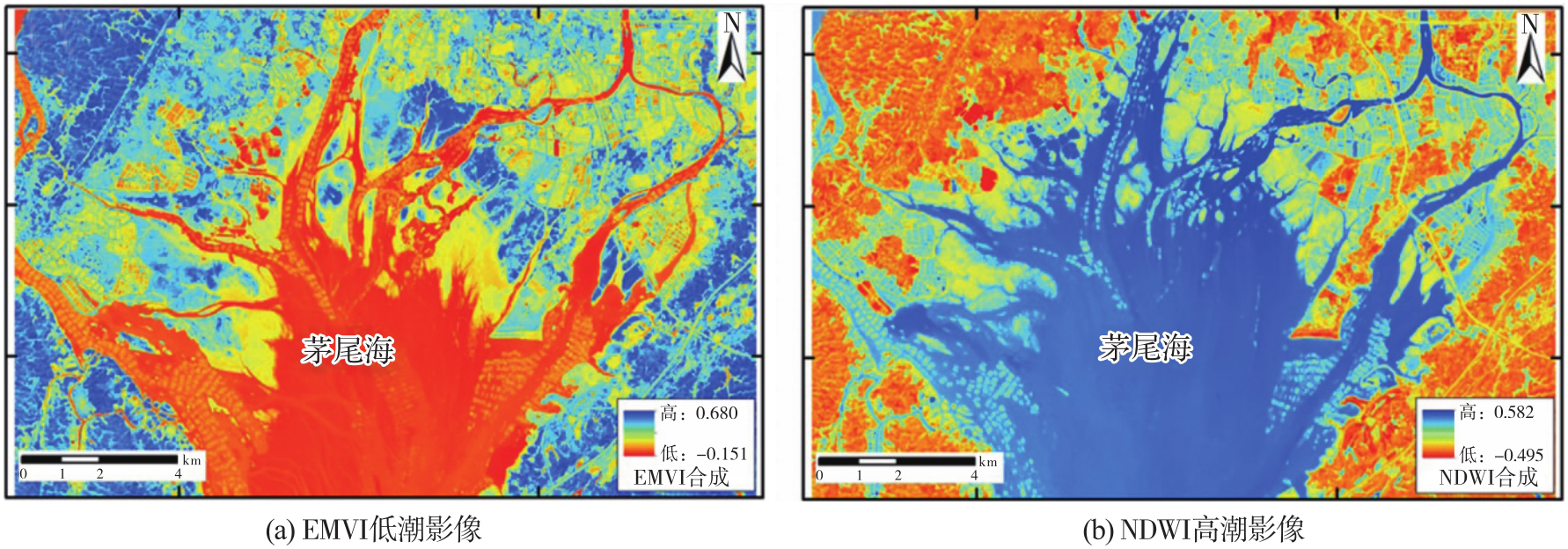
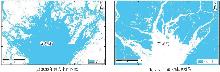
图5
二值化后水体和陆地分布"
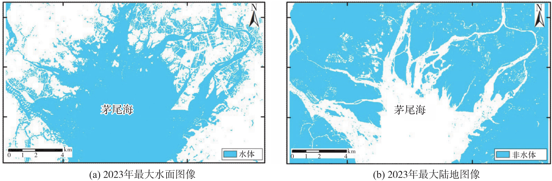
图6
时空基线连接图和空间基线连接图"
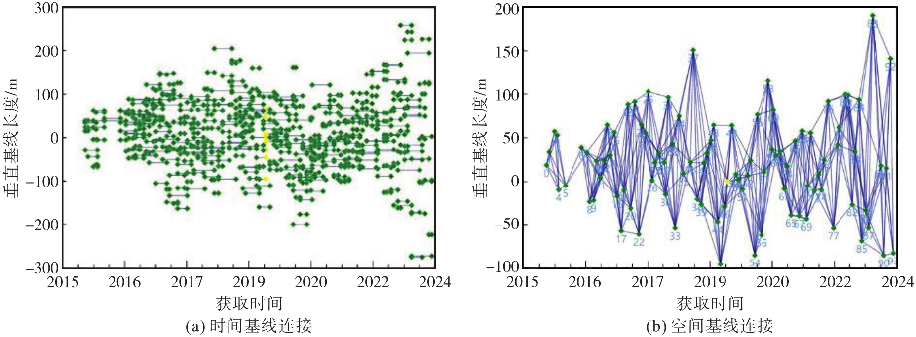
图7
茅尾海地区潮滩时序形变过程"
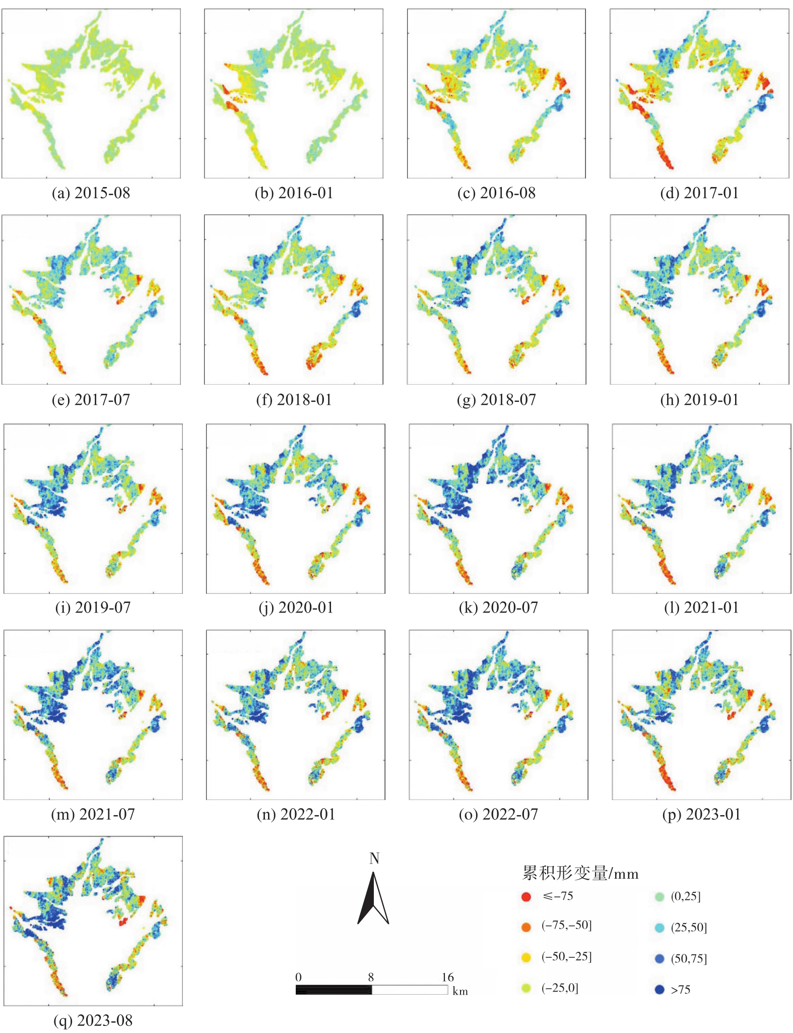
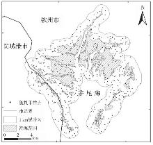
图8
采样点与缓冲区分布"
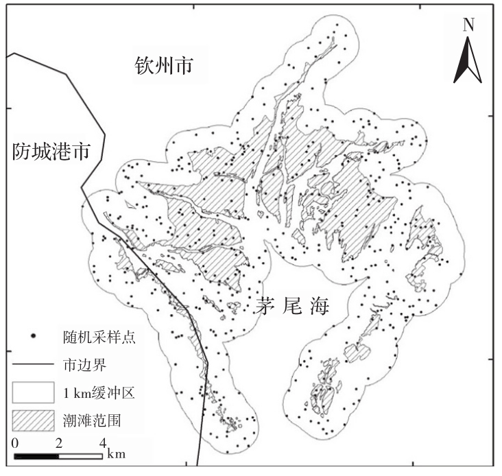
表2
潮滩提取精度评价混淆矩阵"
| 提取类型 | 地物类别 | 用户精度 | ||
|---|---|---|---|---|
| 潮滩 | 其他 | 行总计 | ||
| 潮滩 | 143 | 6 | 149 | 95.97% |
| 其他 | 11 | 340 | 351 | 96.87% |
| 列总计 | 154 | 346 | 500 | — |
| 制图精度 | 92.86% | 98.27% | — | — |
| 总体分类精度:96.60% | Kappa系数:0.92 | |||
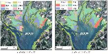
图9
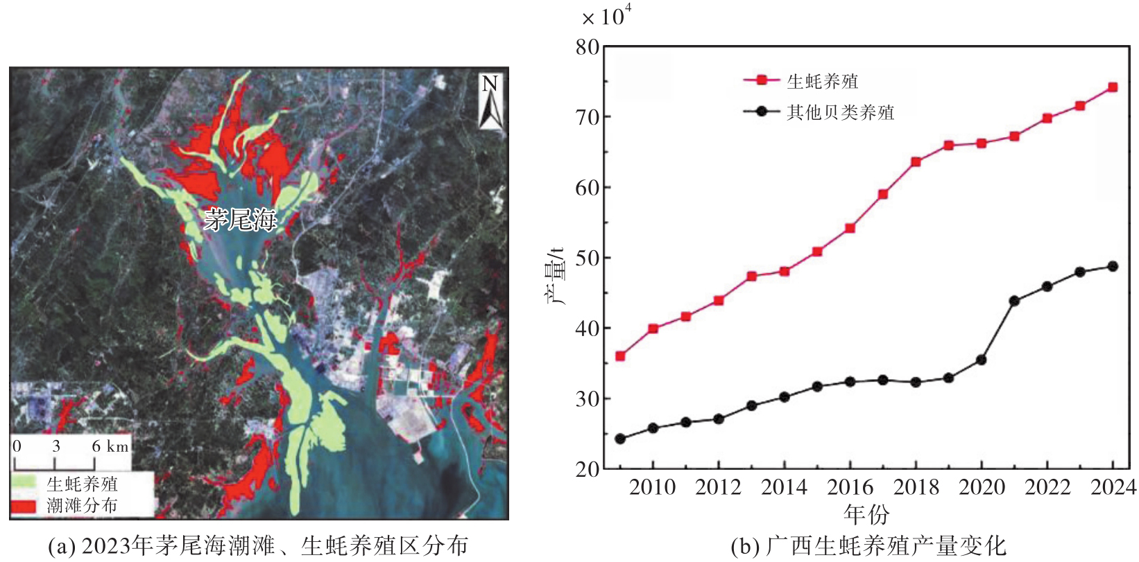
茅尾海潮滩土地利用变化"
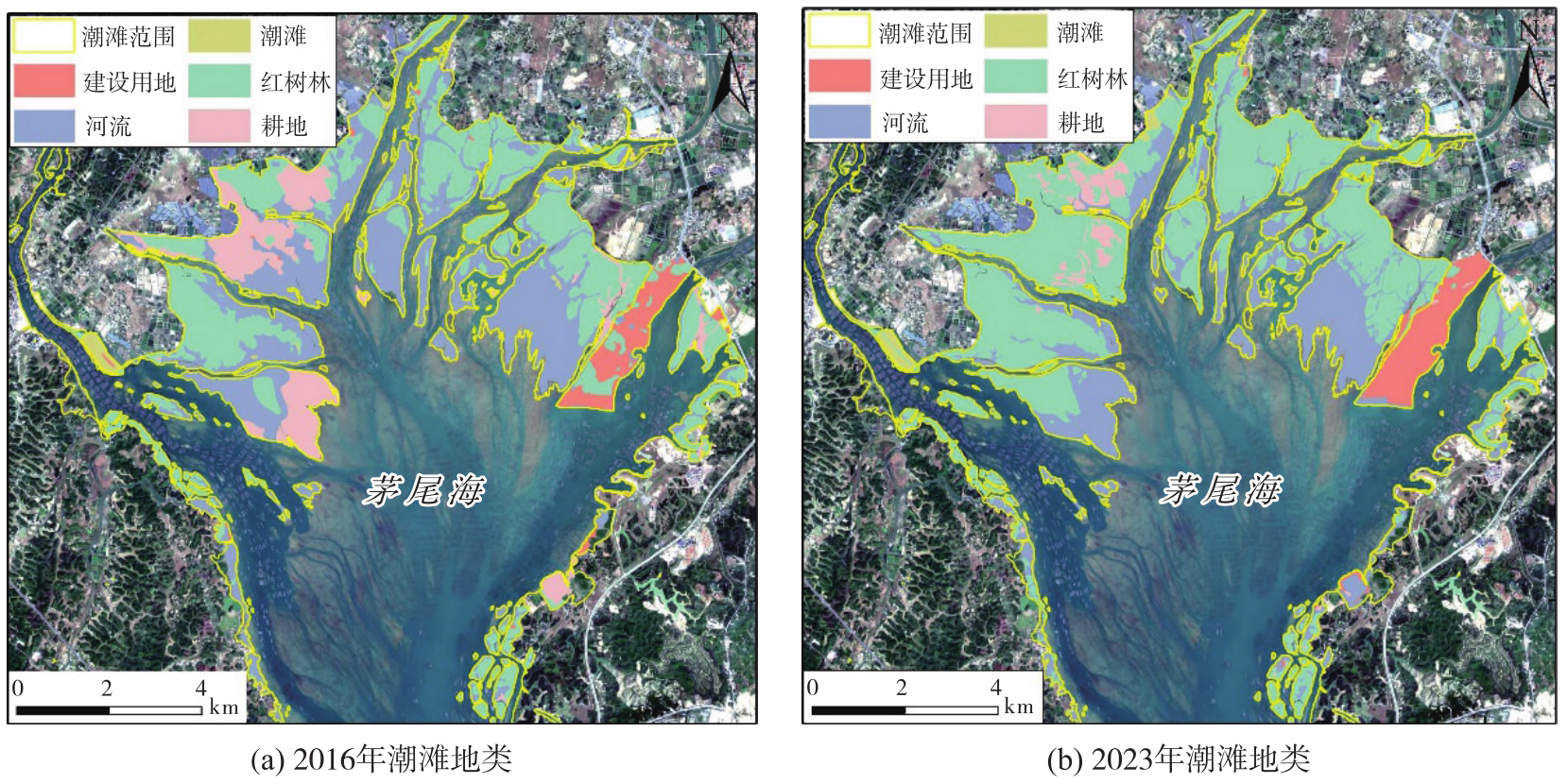
图10
PS+SBAS-InSAR技术获取的形变结果"
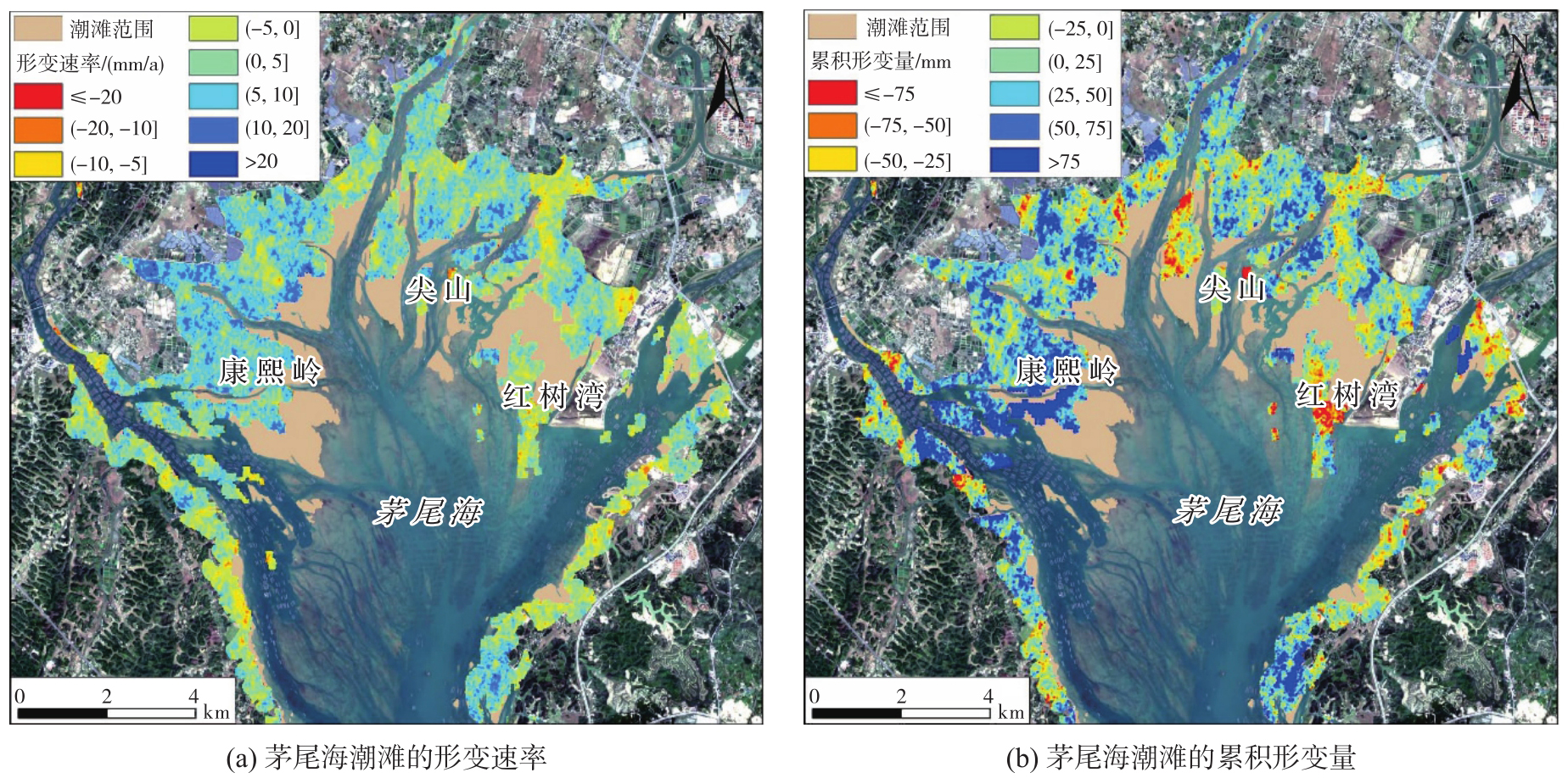
图11
PS-InSAR技术获取的形变结果"
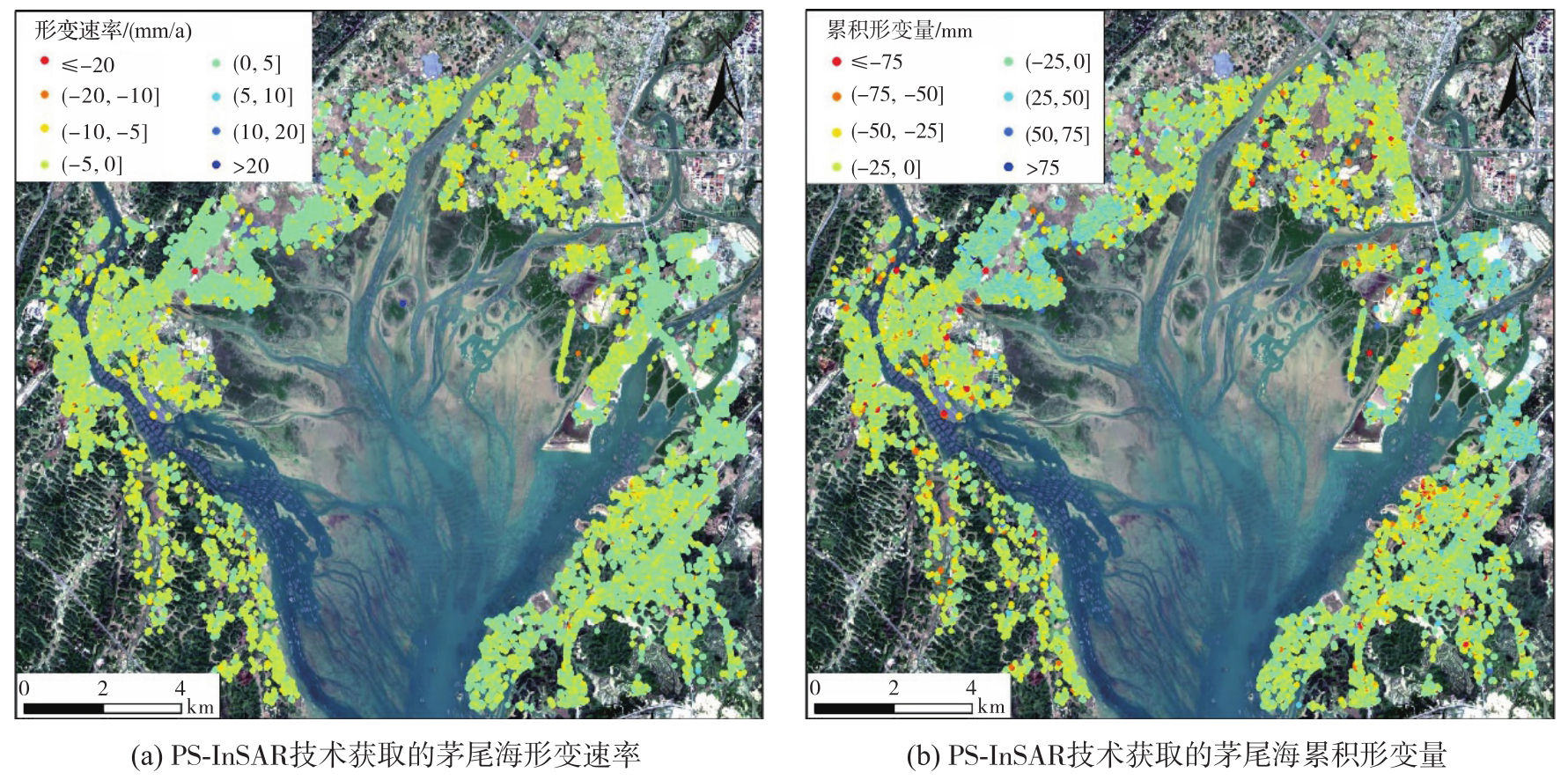
表3
形变速率分布统计"
| 速率范围 | 相干点数量 | 所占比例/(%) |
|---|---|---|
| 速率≤-20 | 876 | 0.26 |
| -20<速率≤-10 | 16 929 | 4.98 |
| -10<速率≤-5 | 44 330 | 13.04 |
| -5<速率≤0 | 87 536 | 25.74 |
| 0<速率≤5 | 96 187 | 28.28 |
| 5<速率≤10 | 59 724 | 17.56 |
| 10<速率≤20 | 31 171 | 9.17 |
| 速率>20 | 3312 | 0.97 |
| 总计 | 340 065 | 100 |
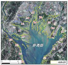
图12
研究区特征点分布"
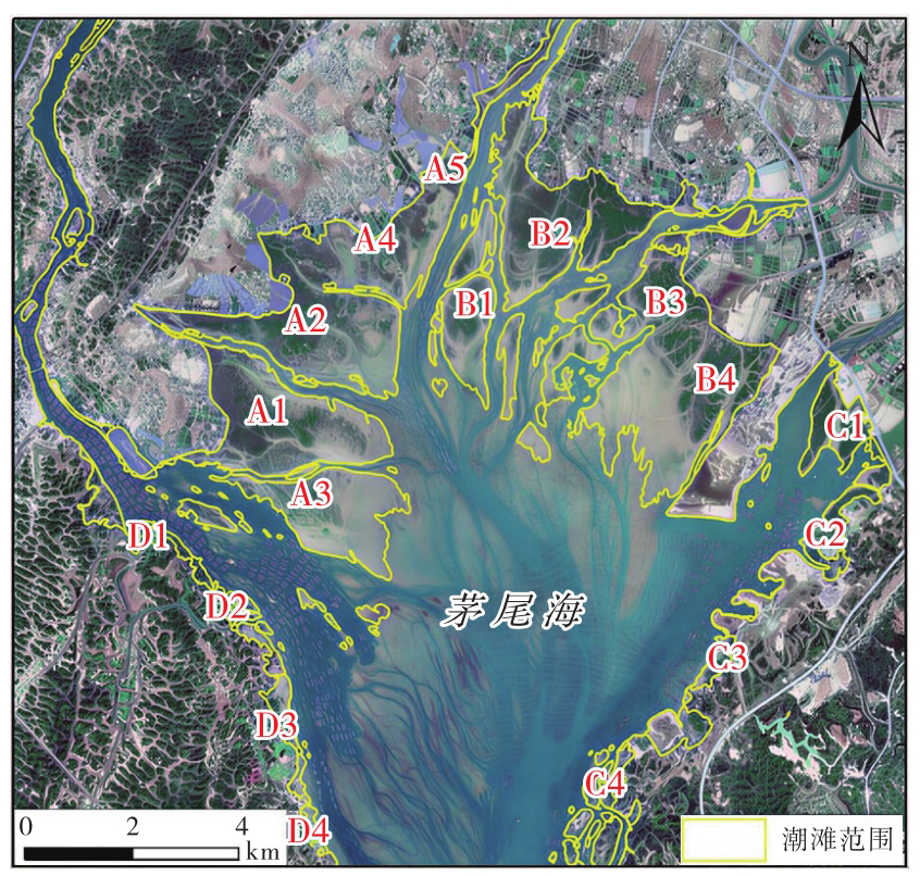

图13
研究区各子区域特征点时序形变"
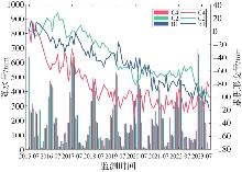
图14
不同特征点的时序形变与降水量的关系"
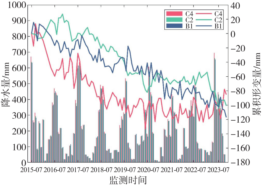
图15
钦江和茅岭江河口潮滩累积形变量"
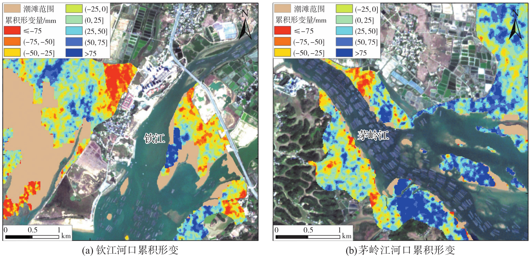
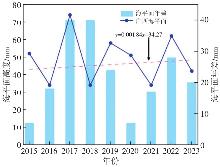
图16
北部湾2015—2023平均海平面变化趋势"
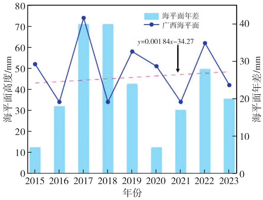
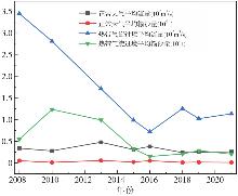
图17
钦江热带气旋和正常天气的平均流量与平均输沙量"
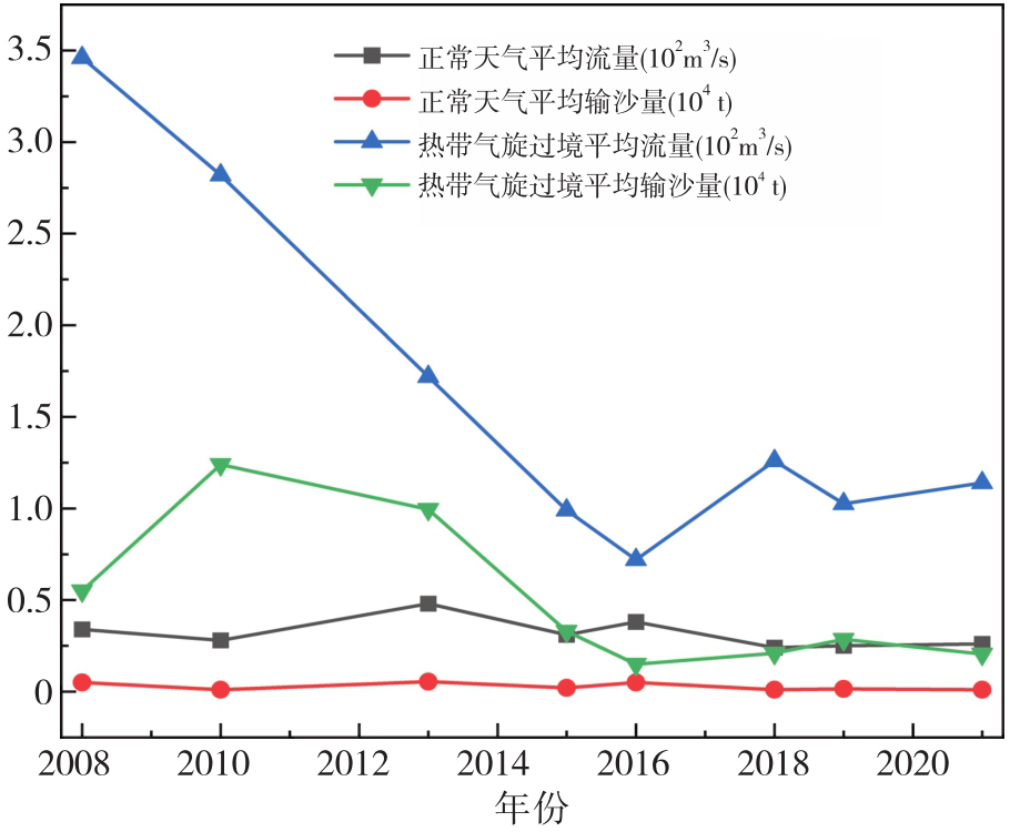
图18
2009—2024年广西生蚝养殖产量变化"
| [1] | HE Qiang, LI Zu'ang, DALEO P, et al. Coastal wetland resilience through local, regional and global conservation[J]. Nature Reviews Biodiversity, 2025, 1(1): 50-67. |
| [2] | GAO Ertao, ZHOU Guoqing, LI Shuxian, et al. Spatio-temporal evolution monitoring and analysis of tidal flats in Beibu Gulf from 1987 to 2021 using multisource remote sensing[J]. IEEE Journal of Selected Topics in Applied Earth Observations and Remote Sensing, 2024, 17: 6099-6114. |
| [3] | WU Wenting, ZHANG Min, CHEN Chunpeng, et al. Coastal reclamation shaped narrower and steeper tidal flats in Fujian, China: evidence from time-series satellite data[J]. Ocean & Coastal Management, 2024, 247: 106933. |
| [4] | TANG Pengfei, GUO Shanchuan, ZHANG Peng, et al. A highly efficient index for robust mapping of tidal flats from sentinel-2 images directly[J]. ISPRS Journal of Photogrammetry and Remote Sensing, 2024, 218: 742-760. |
| [5] | TSAI Y S, TSENG K H. Monitoring multidecadal coastline change and reconstructing tidal flat topography[J]. International Journal of Applied Earth Observation and Geoinformation, 2023, 118: 103260. |
| [6] |
邓开元, 任超. 多光谱光学遥感影像水体提取模型[J]. 测绘学报, 2021, 50(10): 1370-1379. DOI: .
doi: 10.11947/j.AGCS.2021.20200482 |
|
DENG Kaiyuan, REN Chao. Water extraction model of multispectral optical remote sensing image[J]. Acta Geodaetica et Cartographica Sinica, 2021, 50(10): 1370-1379. DOI: .
doi: 10.11947/j.AGCS.2021.20200482 |
|
| [7] | ZHANG Xuhui, ZUO Liqin, LU Yongjun, et al. An improved approach for retrieval of tidal flat elevation based on inundation frequency[J]. Estuarine, Coastal and Shelf Science, 2025, 313: 109061. |
| [8] | MURRAY N J, PHINN S R, DEWITT M, et al. The global distribution and trajectory of tidal flats[J]. Nature, 2019, 565(7738): 222-225. |
| [9] | GORELICK N, HANCHER M, DIXON M, et al. Google Earth Engine: planetary-scale geospatial analysis for everyone[J]. Remote Sensing of Environment, 2017, 202: 18-27. |
| [10] | MURRAY N J, PHINN S P, FULLER R A, et al. High-resolution global maps of tidal flat ecosystems from 1984 to 2019[J]. Scientific Data, 2022, 9: 542. |
| [11] | WANG Xinxin, XIAO Xiangming, ZOU Zhenhua, et al. Tracking annual changes of coastal tidal flats in China during 1986-2016 through analyses of Landsat images with Google Earth Engine[J]. Remote Sensing of Environment, 2020, 238: 110987. |
| [12] | JIA Mingming, WANG Zongming, MAO Dehua, et al. Rapid, robust, and automated mapping of tidal flats in China using time series Sentinel-2 images and Google Earth Engine[J]. Remote Sensing of Environment, 2021, 255: 112285. |
| [13] | 仇传银, 李行, 刘淑安, 等. 长江三角洲滩涂信息的遥感提取及时空变化[J]. 地球信息科学学报, 2019, 21(2): 269-278. |
| QIU Chuanyin, LI Xing, LIU Shu'an, et al. Monitoring tidal flats in the Yangtze River delta using landsat images[J]. Journal of Geo-Information Science, 2019, 21(2): 269-278. | |
| [14] |
王霞迎. InSAR在地表形变监测中的关键技术及应用[J]. 测绘学报, 2022, 51(10): 2244. DOI: .
doi: 10.11947/j.AGCS.2022.20220001 |
|
WANG Xiaying. Key techniques and their application of InSAR in ground deformation monitoring[J]. Acta Geodaetica et Cartographica Sinica, 2022, 51(10): 2244. DOI: .
doi: 10.11947/j.AGCS.2022.20220001 |
|
| [15] |
刘媛媛. 不同尺度综合地表形变InSAR时序监测与机理分析[J]. 测绘学报, 2020, 49(7): 935-935. DOI: .
doi: 10.11947/j.AGCS.2020.20190339 |
|
LIU Yuanyuan. Research on the monitoring and inversion of different-scale complex surface deformation with multi-temporal InSAR[J]. Acta Geodaetica et Cartographica Sinica, 2020, 49(7): 935-935. DOI: .
doi: 10.11947/j.AGCS.2020.20190339 |
|
| [16] | XIONG Jiacheng, HE Xiufeng, Alfred STEIN, et al. Deformation monitoring of the embankments using multi-temporal InSAR: a case study of the Kangshan embankment[J]. Journal of Geodesy and Geoinformation Science, 2025, 8(1): 12-29. |
| [17] | FERRETTI A, PRATI C, ROCCA F. Permanent scatterers in SAR interferometry[J]. IEEE Transactions on Geoscience and Remote Sensing, 2001, 39(1): 8-20. |
| [18] | BERARDINO P, FORNARO G, LANARI R, et al. A new algorithm for surface deformation monitoring based on small baseline differential SAR interferograms[J]. IEEE Transactions on Geoscience and Remote Sensing, 2002, 40(11): 2375-2383. |
| [19] |
朱建军, 李志伟, 胡俊. InSAR变形监测方法与研究进展[J]. 测绘学报, 2017, 46(10): 1717-1733. DOI: .
doi: 10.11947/j.AGCS.2017.20170350 |
|
ZHU Jianjun, LI Zhiwei, HU Jun. Research progress and methods of InSAR for deformation monitoring[J]. Acta Geodaetica et Cartographica Sinica, 2017, 46(10): 1717-1733. DOI: .
doi: 10.11947/j.AGCS.2017.20170350 |
|
| [20] | ZHOU LÜ, ZHAO Yizhan, ZHU Zilin, et al. Spatial and temporal evolution of surface subsidence in Tianjin from 2015 to 2020 based on SBAS-InSAR technology[J]. Journal of Geodesy and Geoinformation Science, 2022, 5(1): 60-72. |
| [21] | LIU Guang, PERSKI Z, SALVI S, et al. Land surface displacement geohazards monitoring using multi-temporal InSAR techniques[J]. Journal of Geodesy and Geoinformation Science, 2021, 4(1): 77-87. |
| [22] | 明小勇, 田义超, 张强, 等. 基于哨兵主被动遥感的茅尾海潮滩地表形变监测与分析[J]. 遥感学报, 2024, 28(9): 2306-2319. |
| MING Xiaoyong, TIAN Yichao, ZHANG Qiang, et al. Monitoring and analysis of surface deformation of tidal flat in Maowei Sea on the basis of Sentinel active and passive remote sensing[J]. National Remote Sensing Bulletin, 2024, 28(9): 2306-2319. | |
| [23] |
李鹏, 白建博, 李振洪, 等. 融合多轨道TS-InSAR的广域海岸带地面沉降监测及成因解析:以山东省为例[J]. 测绘学报, 2025, 54(7): 1178-1191. DOI: .
doi: 10.11947/j.AGCS.2025.20250061 |
|
LI Peng, BAI Jianbo, LI Zhenhong, et al. Wide area coastal subsidence monitoring and driver analysis with multi tracks of TS-InSAR: a case study of Shandong province[J]. Acta Geodaeticaet Cartographica Sinica, 2025, 54(7): 1178-1191. DOI: .
doi: 10.11947/j.AGCS.2025.20250061 |
|
| [24] | 朱武, 张勤, 丁晓利. 多参考点的PS-InSAR变形监测数据处理[J]. 测绘学报, 2012, 41(6): 886-890, 903. |
| ZHU Wu, ZHANG Qin, DING Xiaoli. PS-InSAR deformation monitoring data processing based on multi-reference points[J]. Acta Geodaetica et Cartographica Sinica, 2012, 41(6): 886-890, 903. | |
| [25] | YANG Gang, HUANG Ke, SUN Weiwei, et al. Enhanced mangrove vegetation index based on hyperspectral images for mapping mangrove[J]. ISPRS Journal of Photogrammetry and Remote Sensing, 2022, 189: 236-254. |
| [26] | TALUKDAR S, PAL S. Effects of damming on the hydrological regime of Punarbhaba river basin wetlands[J]. Ecological Engineering, 2019, 135: 61-74. |
| [27] | GAO Bocai. NDWI: a normalized difference water index for remote sensing of vegetation liquid water from space[J]. Remote Sensing of Environment, 1996, 58(3): 257-266. |
| [28] | 陆双龙. 月尺度下的茅尾海营养盐与环境因子的时空变化及空间自相关特征研究[D]. 南宁: 南宁师范大学, 2021. |
| LU Shuanglong. Spatiotemporal variation and spatial autocorrelation of nutrient and environmental factors in Maowei Sea at monthly scale[D]. Nanning: Nanning Normal University, 2021. | |
| [29] | 黎树式, 黄鹄. 近50年钦江水沙变化研究[J]. 广西科学, 2018, 25(4): 409-417. |
| LI Shushi, HUANG Hu. Variations of runoff and sediment in Qinjiang River in the past 50 years[J]. Guangxi Sciences, 2018, 25(4): 409-417. | |
| [30] | LEUVEN J R F W, PIERIK H J, VAN DER VEGT M, et al. Sea-level-rise-induced threats depend on the size of tide-influenced estuaries worldwide[J]. Nature Climate Change, 2019, 9(12): 986-992. |
| [31] | 罗新正, 孟宪伟. 基于相对海平面变化的广西茅尾海红树林面积稳定性评估[J]. 海洋环境科学, 2022, 41(6): 881-887. |
| LUO Xinzheng, MENG Xianwei. Assessment of mangrove area stability based on relative sea level change in Maowei Sea, Guangxi[J]. Marine Environmental Science, 2022, 41(6): 881-887. | |
| [32] | 许珊珊, 杨夏玲, 黎树式, 等. 北部湾钦江响应极端天气的水沙变化过程[J]. 热带地理, 2023, 43(11): 2135-2145. |
| XU Shanshan, YANG Xialing, LI Shushi, et al. Variations in the characteristics of water and sediment in response to extreme weather conditions in the Qinjiang River of the Beibu Gulf[J]. Tropical Geography, 2023, 43(11): 2135-2145. | |
| [33] | 江锐捷, 程鹏, 高建华, 等. 红树林对潮流底边界层动力过程的影响[J]. 海洋地质前沿, 2020, 36(4): 37-44. |
| JIANG Ruijie, CHENG Peng, GAO Jianhua, et al. Impacts of mangrove on the dynamic process of bottom boundary layer[J]. Marine Geology Frontiers, 2020, 36(4): 37-44. | |
| [34] | 王日明, 苏金恒, 戴志军, 等. 钦州湾茅岭江河口红树林湿地动态变化过程[J]. 热带海洋学报, 2025, 44(6): 143-154. |
| WANG Riming, SU Jinheng, DAI Zhijun, et al. Dynamic changes in mangrove wetland of the Maolingjiang Estuary, Qinzhou Gulf[J]. Journal of Tropical Oceanography, 2025, 44(6): 143-154. | |
| [35] | 焦海峰, 郑丹, 严巧娜, 等. 温度、盐度及交互作用对僧帽牡蛎(Saccostrea cucullata)呼吸排泄的影响[J]. 生态学报, 2017, 37(2): 692-699. |
| JIAO Haifeng, ZHENG Dan, YAN Qiaona, et al. Effects of water temperature and salinity on oxygen consumption rate and ammonia excretion rate of Saccostrea cucullata[J]. Acta Ecologica Sinica, 2017, 37(2): 692-699. |
| [1] | 李鹏, 张家涵, 汪志翰, 王厚杰, 李振洪. 潮间带地形重建方法综述:现状、挑战与趋势[J]. 测绘学报, 2026, 55(4): 571-587. |
| [2] | 吴岚昕, 彭江涛, 孙伟伟, 杨冰. 面向海岸带湿地高光谱遥感的欧拉映射与互补特征建模变化检测方法[J]. 测绘学报, 2026, 55(4): 618-631. |
| [3] | 叶晨鸣, 康志忠, 才谨豪, 左秉正, 邵帅, 李彦. 形态特征引导的月表地理实体实景三维建模方法[J]. 测绘学报, 2026, 55(3): 525-535. |
| [4] | 季顺平, 刘瑾, 高建, 龚健雅. 多视影像深度学习密集匹配三维重建智能框架[J]. 测绘学报, 2025, 54(9): 1633-1646. |
| [5] | 闫凯, 徐健明, 王桥. 地表异常遥感探测轻量化大模型方法[J]. 测绘学报, 2025, 54(9): 1664-1676. |
| [6] | 吴田军, 李曼嘉, 骆剑承, 李子琪, 胡晓东, 郜丽静, 沈占锋. 耦合空间分布模式的复杂山区地块作物遥感分类方法[J]. 测绘学报, 2025, 54(7): 1215-1229. |
| [7] | 谢亚坤, 赵耀纪, 涂佳星, 夏瑞丰, 冯德俊, 刘苏凝, 陈虹宇, 朱军. 融合边缘与全局特征的遥感影像显著性目标检测方法[J]. 测绘学报, 2025, 54(7): 1265-1279. |
| [8] | 董子博, 王竞雪, 卜丽静, 房琳, 许峥辉. MAFNet:基于多尺度空洞融合网络的遥感影像建筑物提取方法[J]. 测绘学报, 2025, 54(6): 1094-1106. |
| [9] | 李海峰, 郭旺, 吴梦伟, 彭程里, 朱庆, 刘瑜, 陶超. 视觉-语言联合的遥感地物概念表达与智能解译:原理、挑战与机遇[J]. 测绘学报, 2025, 54(5): 853-872. |
| [10] | 王超, 陈天宇, 张同, AhmedTanvir, 纪立强, 谢涛, 杨佳俊, 王帅. 基于全局差分增强模块和平衡惩罚损失的多源光学遥感影像变化检测[J]. 测绘学报, 2025, 54(5): 873-887. |
| [11] | 赵一鸣, 胡克林, 涂可龙, 卿雅娴, 杨超, 祁昆仑, 吴华意. 基于SAR与光学遥感影像融合的多标签场景分类方法[J]. 测绘学报, 2025, 54(5): 911-923. |
| [12] | 张新长, 齐霁, 陶超, 傅思扬, 郭明宁, 阮永检. 光学遥感影像去云研究进展、挑战与趋势[J]. 测绘学报, 2025, 54(4): 603-620. |
| [13] | 高永刚, 刘雨婷, 徐涵秋. 基于Landsat长时间序列影像的城市生态品质时空演变及驱动因素分析[J]. 测绘学报, 2025, 54(3): 510-522. |
| [14] | 侯昭阳, 闫浩文, 张黎明, 马荣娟, 屈睿涛. 基于耦合神经P系统与区块链的遥感影像零水印版权保护方法[J]. 测绘学报, 2025, 54(12): 2247-2261. |
| [15] | 武昊, 侯东阳, 张俊, 张平, 刘玉轩, 杜磊, 康路, 程滔, 陈军. 动态服务计算支持的自然资源遥感监测监管平台关键技术研究[J]. 测绘学报, 2025, 54(11): 1992-2008. |
| 阅读次数 | ||||||
|
全文 |
|
|||||
|
摘要 |
|
|||||